Petrography, modal composition and tectonic provenance of some selected sandstones from the Molteno, Elliot and Clarens Formations, Karoo Supergroup, in the Eastern Cape Province, South Africa
-
 ,
,

Abstract
The Late Triassic - Early Jurassic non marine clastic sediments of the Molteno, Elliot and Clarens Formations were studied to deduce their mineralogy and tectonic provenance. The study is based on road-cut exposures of the formations in the Eastern Cape Province of South Africa. Petrographic studies based on quantitative analysis of the detrital minerals shows that the clastic sediments (mostly sandstones) are predominantly made up of quartz, feldspars, and metamorphic and igneous rock fragments. Among the main detrital framework grains, quartz constitutes about 62-91%, feldspar 6-24% and 3-19% of lithic fragments. The sandstones can be classified as both sublitharenite and subarkose. Although, most of the sandstones (> 70 %) plotted in the sub-litharenite field. Petrographic and XRD analyses revealed that the sandstones originated from granitic and metamorphic rock sources. The QFL (Quartz-feldspar-lithic fragments) ternary diagrams indicate that the sandstones were derived from recycled or quartzose source rocks reflecting a craton interior or transitional continental setting which probably came from the Cape Fold Belt. This possibly revealed that most of the sandstones might have been derived as a result of weathering and erosion of igneous and metamorphic rocks in the Cape Supergroup. The study has revealed the depositional environments, and provide a basis for the description and interpretation of the sedimentology of the Molteno, Elliot and Clarens Formations.
1 Introduction
Sedimentary rocks, particularly sandstones, are commonly used to construe provenance and to identify ancient tectonic settings since clastic detrital components preserve detailed information on the provenance, sediments transportion and the interaction of physical and chemical processes [1, 2]. Petrography of sandstones reveal more on the provenance of the detritus despite the fact that their original compositions are influenced by processes such as weathering, transportation and diagenesis [3]. [4] documented that other factors like source area characteristics, orogenesis, multicycling, storage pathways and/or leaching also contribute to the formation of clastic sediments. Provenance analysis is done to determine the parent source rock constituencies of sediments as well as palaeogeographic conditions under which the sediments were formed. [5] highlighted that provenance encompasses all factors that facilitate the production of sediments. As documented by [3], tectonic setting of the sedimentary basin is believed to have an overall control on the composition of sedimentary rocks. Owing to the fact that, different tectonic environments have specific mineral composition characteristics which are unique to a particular sedimentary processes. Provenance studies enable the determination of sediment characteristics which are derived from measurements of compositional and textural properties and can then be supplemented by information from other investigations ([6] in [7]). With the aid of petrographic analysis, it becomes possible to understand and reconstruct the palaeodepositional history of sedimentary rocks.
The Karoo is a semi-desert region of southern Africa with vast distribution of sedimentary rocks. The sedimentary part of the Karoo Basin fill consists of the Dwyka (Westphalian-Early Permian), Ecca (Permian), Beaufort (Permo-Triassic) and Stormberg Groups (Late Triassic-Early Jurassic) (Figure 1; Table 1). Recent basinal investigations have shown differences in the stratigraphic sequence, palaeocurrent direction, sedimentary structures, petrographic composition, depositional setting during the basin formation and developmental processes [7, 8]. Geographically, the Molteno, Elliot and Clarens Formations covers an area of approximately 25,000 km2 and forms an oval shaped basin that extends from the Northern-Eastern Cape Province of South Africa into Lesotho, KwaZulu Natal and Free State in South Africa [9]. In the Eastern Cape Province, the Upper Triassic/Lower Jurassic succession from the Molteno Formation up to Clarens Formation reveals a gradual aridification trend from braided rivers to semi-arid fluvial/playa, and subsequently aeolian dune conditions [10]. Based on the palaeogeographic condition and basin tectonic structure, the Eastern Cape Province of South Africa is believed to have the thickest and most completed succession of the Molteno, Elliot and Clarens Formations sediments of the Karoo Basin [11]. In the study area, the Molteno, Elliot and Clarens Formations are considered to represent a transition from humid to arid climate and from cratonic sedimentation to active volcanic eruption [11]. These formations recorded the developmental history of the Karoo Basin and the breakup processes of the Gondwana continent. Previously, there have not been much detailed studies to examine the petrography, modal composition, tectonic provenance and depositional history of these formations in relation to the basin development. Hence, till date, the mineralogical composition, classifcation and source(s) of sandstones of the Molteno, Elliot and Clarens Formations are still not-well understood. This study was undertaken to interpret the sandstones petrography in order to characterize the sandstones of the Molteno, Elliot and Clarens Formations and to infer their provenance in the southeastern Karoo Basin of South Africa.
Lithostratigraphy of the Karoo Supergroup in the Eastern Cape Province as compiled by the Council for Geoscience [11].
|

![Figure 1 Geological map of the preserved Karoo Basin showing the outcrop distribution of the main lithostratigraphic units of the Karoo Supergroup and location of the study area (After [8]). The cross-section transect in the upper map connects the proximal (south) to the distal (north-east) facies. The profile (A-B) connects the proximal (south) to the distal (north-east) facies in the area studied by [8] and depicted in Figure 2.](/document/doi/10.1515/geo-2018-0064/asset/graphic/j_geo-2018-0064_fig_001.jpg)
Geological map of the preserved Karoo Basin showing the outcrop distribution of the main lithostratigraphic units of the Karoo Supergroup and location of the study area (After [8]). The cross-section transect in the upper map connects the proximal (south) to the distal (north-east) facies. The profile (A-B) connects the proximal (south) to the distal (north-east) facies in the area studied by [8] and depicted in Figure 2.
2 Generalized Geology and Stratigraphy
The word “Karoo” was coined from the Main Karoo Basin of South Africa to describe sedimentary fill of all basins of akin age across Gondwana. The Main Karoo Basin is a large sedimentary depository lying north of the Cape Fold Belt in South Africa. The bulk of the Karoo strata occurs in the Main Karoo Basin, with maximum preserved thickness of about 12 km along the southern margin of the basin [8, 11]. The basin developed within the continental interior of southwest Gondwana and covers up to 700, 000 km2 [12, 13]. But it was much more extensive during the Permian [14] and represents about 117 Ma of sedimentation spanning from 300 Ma to 183 Ma [15]. In addition, the basin is underlain by a stable basement comprising the Kaapvaal Craton in the north [8, 16], the Namaqua-Natal Metamorphic Belt (NNMB) in the south [17] and the Cape Fold Belt (CFB) along its southern margin [11]. The Main Karoo Basin is a unique type of basin of all the Karoo basins in southern Africa because it contains the thickest and stratigraphically most complete mega-sequence of several depositories of the Permo-Carboniferous to Jurassic age sediments in southwestern Gondwana continent [8].
![Figure 2 Stratigraphic cross-section of the Karoo Supergroup along the profile shown in Figure 1 [8].](/document/doi/10.1515/geo-2018-0064/asset/graphic/j_geo-2018-0064_fig_002.jpg)
The Karoo depositional cycle and palaeoenvironments commenced with Late Carboniferous glacial deposits of the Dwyka Group, followed by the Permian Ecca Group which contains significant hydrocarbon deposits associated with the deltaic and lacustrine environments [11]. The Middle Permian-Middle Triassic Beaufort Group lies above the Ecca Group, and it is composed of fluvio-lacustrine rocks [11]. The Late Triassic Molteno Formation overlies the Beaufort Group, and it was deposited under warm to humid conditions in broad perennial braided river systems [18, 19]. The argillaceous Elliot Formation that overlies the Molteno Formation was deposited by high and low sinuosity fluvial systems under semi-arid climatic conditions [19]. Progressive aridification led to the deposition of the aeolian dune complexes of the Clarens Formation on the Elliot Formation [11, 20]. The end of the Karoo sedimentation was brought about by the continental flood basalts of the Drakensberg Group which marked the initiation of the Gondwana breakup [20]. [8, 21] are of the view that the Karoo sediments were accumulated within an intracratonic retro-arc foreland basin and a number of processes influenced the depositional settings through different climatic regimes. The tectonic activities that took place were in response to the subduction of the Paleo-Pacific plate beneath the Gondwanan plate, and this triggered basinal subsidence which facilitated the building of the adjacent Cape Fold Belt that served as the provenance for the basin sediments [20]. The glaciers that covered the Karoo Basin during the Late Carboniferous-Middle Permian Period started retreating resulting in high sedimentation which filled the basin in a deep-water environment [8]. As the glaciation process stopped, climate gradually became warmer, the basin began to shallow (thins northward, producing a highly asymmetrical basin) as shown on the cross sectional view (Figure 2) and sedimentation continued as fluvial-lacustrine and then aeolian deposits [8].
The Stormberg Group is an informal stratigraphic division name, which is collectively made up of three formations, namely, Molteno, Elliot and Clarens Formations. The South African Committee for Stratigraphy [22] highlighted that there are no unifying lithological features in the various units of the Stormberg Group which distinguishes them from all the geological groups of the Karoo Basin. The Committee further suggested discontinued use of “Stormberg” as a group title to formally describe the lithostratigraphy of the Molteno, Elliot and Clarens Formations [23]. [24] is of the opinion that the Stormberg Group sediments form a unique tectono-sedimentary sequence which lies between the Beaufort and Drakensberg Groups and was deposited north of the Cape Fold Belt as a direct result of the sediment production by the Cape Fold Belt. The Molteno Formation was deposited within braided river channels and resulted in the formation of conglomerate, sandstone, shale and mudstone as well as coal seams [10, 25]. [26] divided the Molteno Formation into 3 members; the basal Boesmanhoek Member, the Indwe Sandstone Member and the upper the Kramberg Member. [27], in his studies of the Molteno Formation considered the Indwe Sandstone to be a regionally extensive unit and this view was supported by [25] when he identified the Indwe Sandstone Member as a lithostratigraphic marker horizon of regional importance, and it is the only unit which has been formally defined by the South African Committee for Stratigraphy [22]. The overlying Elliot Formation is typical red bed, and was deposited through floodplain – playa sedimentation. The semi-arid climate and high salinity of these floodplain/playa resulted in the formation of red-brownish mudstone and sandstone [28]. Analysis of the Elliot sandstones revealed two contrasting geometries resulting from different fluvial depositional styles. The lower parts of the formation was be interpreted as deposits of meandering river systems and the upper parts deposited through ephemeral fluvial processes [29]. The Clarens Formation that overlies the Elliot Formation represents the final stage of the aridification process. It consists of sandstones and sandy siltstones formed from aeolian processes [8, 10]. The Clarens Formation contains a central zone that indicates a true desert condition which is dominated by an aeolian dune environment and the westerly wind transported the sand [28]. [30] documented that towards the final stage of deposition of the Clarens Formation, the climate became fairly moderate and wet desert processes of stream and sheet flood became more dominant [8]. The Clarens Formation is overlain by the basaltic lavas of the Drakensberg that forms the top of the Karoo sequence, and is believed to have terminated sedimentation within the basin in the Middle Jurassic [11].
3 Material and Methods
A total of ninety (90) sandstones samples were collected from outcrops of the Molteno, Elliot and Clarens Formations within the Eastern Cape Province (Figure 1). Fifteen (15) representative thin sections of different types of sandstones were prepared and studied under optical microscope and applied to modal composition analysis. The selected sandstones (four samples from the Molteno Formation, six samples from the Elliot Formation and five samples from the Clarens Formation) were labelled with prefixes M, E and C to represent samples from the Molteno, Elliot and Clarens Formations respectively. Four to six samples for each formation might look not sufficient to adequately characterize each of these formations due to heterogeneity of sedimentary sequences. Nevertheless, an attempt was made to collect reasonably representative samples to represent the geologic deposit that is the object of study. Samples for each formation was collected at different locations (Figure 1) and in each of these areas, at least one sample was selected and thin section prepared. The selected 15 representative thin sections of different types of sandstone were chosen based on difference or variation in lithology, grain-size distribution, textural characteristics, sedimentary facies, and petrographic composition (mineralogy). For example, at least one thin section was selected to represent a particular facies and the sample size was large enough to represent adequately the finest and coarsest component under consideration. The representative samples possess many of the same characteristics as the targeted formation such that data generated from the sample will represent more than just the sample from which they were obtained, but extended to the entire formation in the study area. The comparative abundance of the main mineral components was determined by counting a minimum of 400 points in each thin section based on the Gazzi-Dickinson’s method and the nomenclature suggested by [31]. The modal composition analysis (point-counting) was carried out using an Olympus BX51 microscope equipped with an Olympus DP72 digital camera. An evenly spaced counting grid was employed to traverse the thin section, and mineral grains under the grid nodes were counted. The grids were equally spaced in such a way that each grid exceeds the average grain size in order to avoid counting an individual grain more than once. Framework constituents were determined using the nomenclature proposed by [1, 3, 32]. Mineral constituents of the sandstones were categorized into monocrystalline quartz, polycrystalline quartz, K-feldspar, plagioclase, lithic fragments, accessory minerals and matrix. Quartz, K-feldspar, Ca-feldspar, lithic fragments, mica and heavy minerals were all accounted for and used for modal analysis, while the matrix, cement, and other authigenic accessory minerals were only counted but excluded for modal analysis. So as to classify the sandstones, framework detrital modes of the sandstones were recalculated to 100 % and Q-F-L (Quartz-feldspar-lithic fragments) ternary diagrams were plotted. In this study, the Q-F-L ternary diagrams proposed by [33, 34] were used to classify the sandstones as well as infer their provenance(s). In addition, mineralogical composition of the sandstones was determined by X-ray diffraction (XRD) and used to confirm or support the petrographic framework.
4 Results
4.1 Sandstone petrography
4.1.1 Quartz
The most dominant mineral which constitutes large percentage of the detrital grains in the sandstones is quartz.
Framework parameters of detrital modes (After [3]).
| A | Quartzose | (Qt = Qm + Qp) |
| Grains | Qt = Total quartz grain | |
| Qm = Monocrystalline quartz grain | ||
| Qp = Polycrystalline quartz grain | ||
| B | Feldspar | F = (P+K) |
| Grains | F = Total feldspar grain | |
| P = Plagioclase feldspar grain | ||
| K = Potassium feldspar grain | ||
| C | Unstable | L = Lv + Ls, Lithics |
| Lithic | Lv = Volcanic / meta-volcanic lithic fragment | |
| Fragments | Ls = Sedimentary/metasedimentary lithic fragment | |
| D | Total Lithic | Lt = (L+ Qp), Total lithics |
| Fragments | Lc = Extra basinal detrital lime-clasts (not included in L or Lt) |
The total quartz content in the sandstones of the Molteno, Elliot and Clarens Formations range between 72-86%, 70-87% and 66-90% respectively. Both monocrystalline and polycrystalline quartz grains are present in the sandstones, with the monocrystalline quartz, averaging 75%, 78%, and 74% in the Molteno, Elliot and Clarens Formations respectively. Some of the monocrystalline grains tend to show undulose extinction. The monocrystalline quartz grains mostly have sub-rounded to sub-angular shape (Figure 3a). The quartz grains occasionally have secondary overgrowths that precipitated around the original detrital grain boundary (Figure 3b). Recrystallized quartz mostly from metamorphic origin occurs mainly as polycrystalline, composite grains of sub-equant to equant shape while stretched metamorphic 2 quartz is mostly platy to elongate. [40] concluded that quartz grains with nonundulatory extinction most likely originated from non-metamorphic rocks, whereas the grains with undulatory extinction came from metamorphic rock source. On the other hand, significance The individual grain shows almost sub-parallel to parallel orientation and sutured boundaries (Figures 3c and 3d). The polycrystalline quartz grains also show sub-rounded to sub-angular nature with moderate sphericity. As documented by [35], “Strongly undulose and finely polycrystalline quartz grains are indicative of metamorphic source rocks, but quartz grains of plutonic and volcanic origin are characteristically strain free”.
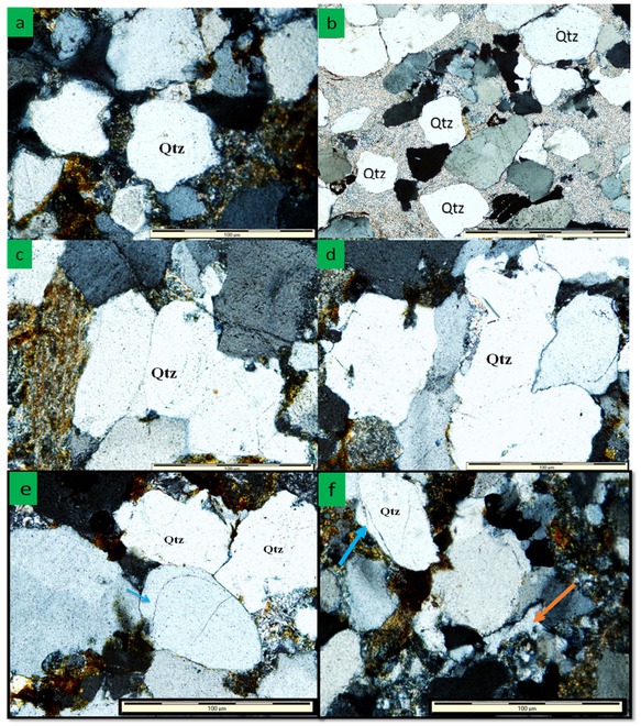
Photomicrograph of quartz grains showing: (a) Subangular quartz grains from the Clarens Formation; (b) Sub-rounded quartz grains with overgrowth (arrow) from the Elliot Formation; (c) Polycrystalline quartz grain from the Elliot Formation; (d) Polycrystalline quartz grain with sutured boundaries from the Molteno Formation; (e) quartz overgrowth (blue arrow) within a sandstone from Molteno Formation; (f) Quartz cement (orange arrow) and quartz overgrowth (blue arrow) within a sandstone of Clarens Formation.
4.1.2 Feldspar
Alkali feldspar (orthoclase and microcline) and plagioclase feldspar (albite) are the feldspar minerals present in the sandstones (Figure 4), with plagioclase feldspar being the most dominant. On the average, the feldspar minerals in the Molteno, Elliot and Clarens Formations are 13.6%, 11.1% and 14.2% respectively. Monocrystalline and polycrystalline feldspar grains are both present in the sandstones. The feldspar grains are texturally sub-rounded to sub-angular and medium to coarse grained in size. Some of the feldspar grains are partially changed to sericite. Ocassionally, they are changed to kaolinite, illite, muscovite or replaced by calcite. Albite and orthoclase are the dominant feldspar minerals occurring in both twinned and untwinned forms. Most of the plagioclase shows twinning, while others appear to be untwinned. Microcline only occurs in minor quantities and are totally absent in some samples. Albite grains are generally elongated and shows parallel twinning, while the microcline exhibits cross-hatch twinning. The orthoclase grains are usally cloudy in colour. Nonetheless, they ocassionally have simple twinning with perthite texture.
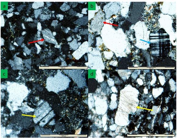
Photomicrograph of feldspar grains showing: (a) K-feldspar grain in the sandstone of the Clarens Formation (red arrow); (b) Microcline (blue arrow) and K-feldspar (red arrow) in the sandstone of the Elliot Formation; (c) Plagioclase (arrow) in the sandstone of the Molteno Formation; (d) K-feldspar grain partially albitized in the sandstone of the Clarens Formation.
4.1.3 Lithic fragments
Lithic fragments constitute only a small fraction as compared to quartz and feldspars. The lithic fragments are made up of metamorphic, sedimentary and igneous rock clasts (Figure 5) and they have an average percentage of 7.9%, 6.73% and 7.9% in the sandstones of the Molteno, Elliot and Clarens Formations respectively. Metamorphic and igneous clasts constitute a larger percentage than volcanic and sedimentary clasts. Metamorphic clasts are mainly shale schist, chert and quartzite, whereas igneous clasts include granitic and granodioritic rock types. Sedimentary rock fragments of sandstone, siltstone and shale constituting a small percentage of the total lithic fragments. These pieces of rocks have been eroded down to sand size and are now sand grains in the sedimentary rock. In addition, The igneous lithic fragments consist mainly of quartz, feldspar and minor alkali minerals that have previously undergone alteration due to auto-hydrothermal reaction. The rock fragments tend to break into their constituent minerals or grains, while argillaceous grains can be squashed, deformed and moulded about the more competent grains.
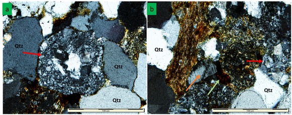
Photomicrograph showing: (a) Metamorphic lithic (red arrow) in sandstone of the Molteno Formation; (b) Igneous lithic (red arrow) in sandstone of the Elliot Formation. Figure 5b also shows partial albitization of clay matrix (orange arrow) and hematite cement (green arrow).
4.1.4 Clay matrix and cement
The detrital framework grains in the sandstone of Molteno, Elliot and Clarens Formations are bound by matrix of clay minerals, quartz, hematite and calcite (Figure 6a-c). The abundant quartz overgrowths make up much of the quartz cement that precipitate within the pore space between original detrital grains. Clay minerals include smectite, kaolinite, sericite and illite. Recrystallization of the clay matrix is a common phenomenon in the sandstones; for example, smectite gradually changes to illite, then to sericite and finally muscovite. Hematite cement is also common cement type in the sandstones. This cement tends to fill up the pore spaces within the sandstone grains.
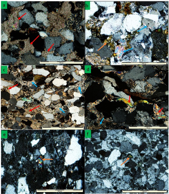
Photomicrograph showing: (a) calcite cement (red arrow) in sandstones of the Molteno Formation; (b) recrystallization of clay minerals into muscovite (blue arrow) and sericite (yellow crystals, orange arrow) in sandstone of the Elliot Formation; (c) calcite cement (red arrows) and clay matrix (blue arrows) in sandstone of the Clarens Formation; (d) detrital muscovite flakes (red arrows) and recrystallized clay matrix to muscovite (blue arrow) in sandstone of the Elliot Formation; (e) detrital muscovite in sandstone of the Molteno Formation; (f) weathered heavy mineral rutile (arrow) in the sandstone of the Clarens Formation.
4.1.5 Mica and accessory minerals
Mica grains occur as random tiny fragments or elongated flakes (Figure 6d and 6e) ranging between 2% to 6%. Muscovite and biotite are the mica in the sandstones and their average percentage composition reaches up to 4%. Muscovite is chemically more stable than biotite and thus is commonly much more abundant in sandstones. Some of the muscovite grains are stained or invaded by chlorite. The detrital muscovite grains are distinguished by their tabular appearance with individual crystals bent through compaction and deformation around quartz grains. Garnet, rutile, zircon, and magnetite are the accessory (heavy) minerals in the sandstones (Figure 6f). These minerals have long been used in sedimentary petrology to deduce the composition of the source rocks of sediments. The presence of a particular heavy minerals is diagnostic of the certain type of source area or provenance, for example, the presence of garnet, rutile and magnetite would imply derivation from igneous source area, whereas the would imply derivation from igneous source area, possibly reworked sediments. It is possible that a sediment to have been sourced or derived from more than one type of source area.
4.2 Mineralogy and modal composition
The summary of the mineralogical composition of the sandstones as detected using XRD analysis is presented in Table 3. Prefixes M, E, and C were used to identify samples from the Molteno, Elliot and Clarens Formations respectively. The most abundant minerals are quartz (72-91%) and plagioclase (8-17%). The mica range between 1-11%, while the heavy minerals like rutile, garnet and zircon only occurred in traces. The modal compositions of the sandstones are presented in Table 4.
X-ray diffraction percentage mineralogical abundances (%) in the sandstones of the Molteno, Elliot and Clarens Formations.
| Formation | Sample label | Sample location | Quartz | Plagioclase | K-feldspar | Mica | Calcite | Kaolinite/Chorite | Laumontite | Smectite | Rutile | Garnet | Zircon | I/S Interstratification |
|---|---|---|---|---|---|---|---|---|---|---|---|---|---|---|
| Clarens | C9 | BE | 76 | 15 | 5 | 3 | - | - | - | - | - | tc | tc | - |
| C11 | BE | 76 | 13 | 5 | 2 | - | - | 4 | - | - | tc | - | - | |
| C18 | BE | 91 | 5 | - | 3 | - | - | - | 2 | tc | tc | tc | - | |
| Cd5 | NE | 74 | 14 | 8 | 2 | - | - | 1 | - | tc | tc | - | - | |
| Cd6b | NE | 62 | 7 | 4 | 1 | - | - | 24 | 2 | tc | - | tc | - | |
| Elliot | E6b | ET | 74 | 10 | - | 12 | - | 4 | - | - | tc | - | tc | - |
| E6c | ET | 88 | 5 | - | 6 | - | 6 | - | - | - | tc | tc | - | |
| E7 | RO | 72 | 17 | - | 11 | - | - | - | - | tc | tc | - | - | |
| E17a | RO | 75 | 16 | 4 | 1 | - | - | - | - | - | - | tc | 5 | |
| E17b | RO | 82 | 12 | - | 6 | - | - | - | - | tc | tc | tc | - | |
| Molteno | M3b | NC | 90 | - | - | 7 | - | 3 | - | - | tc | tc | - | - |
| M4 | ID | 73 | 10 | - | 7 | 1 | 8 | - | - | tc | - | - | - | |
| Md9 | NC | 75 | 11 | - | 9 | 2 | 3 | - | - | tc | tc | tc | - | |
| M14a | NC | 71 | 8 | - | 9 | 3 | - | - | - | tc | - | 8 | ||
| M14b | NC | 75 | 11 | - | 5 | 5 | - | - | tc | tc | tc | 6 |
Note: tc: trace, - : not detected, BE: Barkly East, NE; Near Elliot, ET: Elliot town, RO: Rossouw, NC: Near Cala, and ID: Indwe.
Modal compositions of sandstones from the Molteno, Elliot and Clarens Formations.
| Formation | Sample label | Sample location | Normalised (100%) | |||||
|---|---|---|---|---|---|---|---|---|
| Qt | Qm | Qp | F | L | Lt = (L + Qp) | |||
| Clarens | C9 | Barkly East (S 31° 10.525’, E27° 46.888’) | 75.22 | 73.12 | 2.10 | 19.64 | 5.14 | 7.24 |
| C11 | Barkly East (S 31° 10.525’, E27° 46.888’) | 79.24 | 75.54 | 3.70 | 16.42 | 4.34 | 8.04 | |
| C18 | Barkly East (S 31° 13.504’, E27° 50.9423’) | 90.43 | 85.63 | 4.80 | 6.05 | 3.52 | 8.32 | |
| Cd5 | Near Elliot town | 77.63 | 73.33 | 4.30 | 19.92 | 2.45 | 6.75 | |
| Cd6b | Near Elliot town | 66.42 | 62.82 | 3.60 | 9.20 | 24.38 | 27.98 | |
| Elliot | E6a | Elliot town (S 31° 15.202’, E27° 49.579’) | 85.81 | 81.11 | 4.70 | 8.11 | 6.08 | 10.78 |
| E6c | Elliot town (S 31° 14.411’, E27° 49.277’) | 86.68 | 83.18 | 3.50 | 4.12 | 9.20 | 12.70 | |
| E6d | Elliot town (S 31° 10.950’, E27° 17.636’) | 76.28 | 73.58 | 2.70 | 20.66 | 3.06 | 5.76 | |
| E7 | Rossouw (S 31° 10.950’, E27° 17.636’) | 70.90 | 66.80 | 4.10 | 15.45 | 13.65 | 17.75 | |
| E17b | Rossouw (S 31° 13.539’, E27° 17.232’) | 85.68 | 81.28 | 4.40 | 10.32 | 4.00 | 8.40 | |
| E17c | Rossouw (S 31° 10.950’, E27° 17.636’) | 87.57 | 84.37 | 3.20 | 8.02 | 4.41 | 7.61 | |
| Molteno | M1 | Indwe (S 31° 27.196’, E27° 22.338’) | 82.09 | 78.79 | 3.30 | 12.94 | 4.97 | 8.27 |
| M2c | Near Cala (S 31° 36.928’, E27° 27.932’) | 86.71 | 82.41 | 4.30 | 8.54 | 4.75 | 9.05 | |
| M4 | Indwe (S 31° 36.548’, E27° 30.974’) | 72.42 | 69.72 | 2.70 | 8.86 | 18.72 | 21.42 | |
| Md1 | Indwe (S 31° 36.548’, E27° 30.974’) | 72.52 | 69.52 | 3.00 | 24.00 | 3.48 | 6.48 | |
5 Interpretation and Discussion
5.1 Sandstone petrography and mineralogy
Mineralogical compositions and textural characteristics of the detrital sediments are determined by their parent
rocks and diagenetic processes that exist at the time of sediment deposition and post-depositional processes after transportation of sediments from their source area to the point of deposition. As the sediments are continuously reworked, some exist as lithic fragments and some become distinctive minerals which assist in identification of parent rock. Physical, chemical, and biologic processes subsequently play important roles in determining the variation in mineralogical 4 composition between parent rock and final sedimentary product. Minerals that are less resistant to physical and chemical effects are either altered or they recrystallize into other minerals, whilst the more resistant minerals end up becoming the more dominant minerals. Distance of transportation overall determines the sediment size, shape, sorting and degree of sorting. The sandstones from Clarens and Elliot Formations are mostly fine to medium grained ranging from moderately well sorted to well sorted, while the Molteno Formation sandstones are mostly medium to coarse grained and moderately well sorted. Bulk detritus of the sandstones from the Molteno, Elliot and Clarens Formations is composed of abundant quartz and lesser amounts of feldspars and lithic fragments. [38] pointed out that given an instance whereby quartz is the abundant mineral in a sample compared to the amounts of feldspar, micas and matrix, this scenario gives an indication of how mature the sediments are in relation to the weathering and transportation. The sandstones showed high quartz content, low content of feldspar, sub-rounded and moderately well sorted grains, perhaps indicate relatively long transport distance from the source area. The unstable mineral of feldspar can not survive long distance as it will be affected (destroyed) by both weathering and erosion. Both quartz and feldspar minerals have polycrystalline and monocrystalline grains, indicating that they were not fully separated by the long transportation. The characteristics of the quartz and feldspar grains in the sandstones shows igneous, metamorphic and pre-existing sedimentary rock sources. [37] reported that the dominance of monocrystalline quartz grains indicate that the sediments are mostly derived from a granitic source. [38] suggested that most monocrystalline quartz grains are as a result of the disaggregation of original polycrystalline quartz (quartzite or vein quartz) during high energy or long distance transportation especially from magmatic and metamorphic sources. Considering the genetic and empirical classification of the quartz types as proposed by [39], monocrystalline quartz grains are primarily plutonic, hydrothermal and recycled sedimentary sourced, whereas polycrystalline quartz grains are recrystallized and stretched metamorphic types. The dominance of monocrystalline quartz grains in the sandstones show that the sandstones were mostly derived from a granitic source [37]. The monocrystalline and polycrystalline quartz grains often shows undulatory extinction and exhibit intercrystalline suturing, which indicate metamorphic source(s) area for the sandstones. In support of this, [40] concluded that quartz grains with non-undulatory extinction are mostly sourced from non-metamorphic rocks, whereas the grains with undulatory extinction came from metamorphic rock source. In few cases, some of the polycrystalline quartz grains have three or more crystals with straight to slightly curved intercrystalline boundaries, and as reported by [39, 41], such quartz grains possibly indicate that they were sourced from metamorphic and plutonic igneous rocks.
[37] documented that pure fragments of feldspar grains in sandstones indicate igneous source area, while altered or stained feldspar grains are mostly of metamorphic source area. Both weathered (altered) and a few pure feldspar grains are observed in the sandstones, indicating that the sandstones are probably sourced from igneous and metamorphic source area. Based on sedimentological, geochemical and paleontological (fossil assemblage) evidences, [42] reported thatthe presence of feldspar in the Molteno Formation implies erosion under cold climatic conditions in an area of high relief. This study as well as [29] highlighted that the detrital feldspars in the sandstones of the Molteno, Elliot and Clarens Formations are mostly plagioclase with very few microcline. The plagioclase grains are commonly twinned on the albite law, while the microcline displays tartan (cross-hatched) twins. The existence of few microcline in the sandstones indicates that the source rock is of low grade metamorphic terrain and alkali-rich granites. The sandstones of the Clarens Formation have higher feldspar content than those of the Molteno and Elliot Formations. This is an indication that the sandstones of the Clarens Formation are less mature than the sandstones of the other two formations, probably due to the presence or existence of dry climate and thus feldspar survived as there was less chemical weathering. These sandstones are mostly dominated by quartz and calcite cements as well as a clay matrix which mostly lines the boundary of grains. This reflected the characteristics of dry and arid climatic conditions during and after the deposition of the Clarens Formation sandstones. [6] documented that micas are mostly sourced from metamorphic and igneous rocks. The relative abundance of muscovite and biotite in the studied sandstones show that the source rock is micaceous in nature, perhaps of felsic igneous rocks or metamorphic rocks. The occurence (in traces) of heavy minerals like rutile, garnet and zircon in the sandsones possibly shows that the sandstones are derived from metamorphic, igneous and sedimentary sources.
The identified clay minerals (kaolinite, smectite, calcite and chlorite) possibly exist in the rock either as detrital grains or diagenetic minerals. The sample (Cd6b) from the Clarens Formation is of much interest as a result of the high laumontite content (about 24%). Laumontite is a secondary mineral formed from alteration of zeolite group minerals. Zeolites occur in lavas and clastic volcanics. It is of hydrothermal origin, lining cavities in igneous rocks [43]. Thick sedimentary beds rich in laumontite are said to have formed by decomposition of analcime or metamorphism of plagioclase [44]. In most cases, laumontite occurs as an authigenic mineral, cementing sandstones. It forms together with calcite, chlorite after albitization of plagioclase. Since the Clarens Formation caps the sedimentary succession of the Karoo Basin and is also in contact with the volcalnic Drakensberg Group (contains basalt), there is a possibility that the basaltic lava flows that was present during the Triassic time had an effect on the sedimentary beds of the Clarens Formation. Thus, it is inferred that the formation of authigenic laumontite in the sedimentary sequence represents the hydrogenous catagenetic mineralization related to the circulation of heterogeneous alkaline groundwaters within the sedimentary sequence. The heated circulating groundwater that was released during the volcanic eruptions probably mixed with the hydrothermal solution fluids and reacted chemically with plagioclase to form laumontite. Likewise, excessive calcium may also react with silica to produce laumontite, which fills the cracks or fractures (acted as fracture filling fluids). Laumontite has also been found in Archean metamorphic rocks and their coarse detrital reworking products, as well as in basalts and their tuffs [45]. [45] further states that in some areas, laumontite containing sedimentary sequences were accumulated before or after the intrusive or effusive volcanic activity and the processes were almost synchronous in other places.
5.2 Sandstone classification
The most commonly used and effective methods for sandstone classification integrate both textural characteristics and mineralogy [1, 7, 33, 34, 39]. The Folk’s classification scheme unravel important information about provenance with the rock’s name showing details of its composition as reported by [46]. The QFL ternary diagrams have been effective in deducing the relationship between plate tectonic settings and sandstone compositions. [3] supported the use of ternary diagrams as a way of providing effective discrimination for different plate tectonic settings, thus enabling tectonic reconstruction of terrigenous deposits. [36] pointed out that given an instance whereby quartz is the abundant mineral in a sample, compared to the amounts of feldspar, micas and matrix, this scenario gives an indication of how mature the sediments are in relation to the weathering and transportation. Based on the classification scheme proposed by [33], the sandstones of the Molteno, Elliot and Clarens Formations can be classified as both sub-litharenite and subarkose (Figure 7). Most of the sandstones (>70 %) plotted in the sub-litharenite field. The QFL ternary diagram proposed by [34] also shows that about 70% of the sandstones plotted in the sub-litharenite field, while the remaining 30% plotted in the lithic arkose, lithic subarkose, and lithic arenite (Figure 8).
![Figure 7 Q-F-L ternary plot of data presented in Table 4 showing classification of sandstones from the Molteno, Elliot and Clarens Formations (After [33]).](/document/doi/10.1515/geo-2018-0064/asset/graphic/j_geo-2018-0064_fig_007.jpg)
![Figure 8 Q-F-L ternary plot of data presented in Table 4 showing classification of sandstones from the Molteno, Elliot and Clarens Formations (After [34]).](/document/doi/10.1515/geo-2018-0064/asset/graphic/j_geo-2018-0064_fig_008.jpg)
5.3 Provenance and tectonic setting
Provenance studies of sandstone are generally founded on the notion that different tectonic environments have distinguishing or unique characteristic rock types [3]. Several researchers like [1, 2, 7, 33, 34, 47] have associated detrital compositions of sandstones to different provenance types (i.e. stable cratons, basement uplifts, magmatic arcs and recycled orogens) using the QFL ternary diagrams. [32] in [7] reported that the average compositions of sandstone suites sourced from different tectonic settings/environments controlled provenance terranes tend to plot within distinct and separate fields on QFL diagrams. The QFL ternary plots proposed by [33, 34] have also been attempted for sandstones from the Molteno, Elliot and Clarens Formations in order to unravel their tectonic settings.
In the Qt-F-L ternary diagram (Figure 9), the sandstones of the Molteno, Elliot and Clarens Formations plotted in the recycled orogen field. This is an indication that the sediments’ sources were derived from recycled orogeny. Sandstones derived from subduction complexes or fold thrust belts are mostly associated with recycled orogen [1]. In addition, recycled orogens indicate increasing maturity in mineralogy. As documented by [1, 32], within recycled orogens, sediment sources are mostly sedimentary with minor volcanic rocks, partly metamorphosed and uncovered or exposed to erosion by orogenic uplifted foldbelts. The Qm-F-Lt plot (Figure 10) shows that the sandstones falls within the craton interior, quartzose recycled, transitional continental and mixed zone. Most of the sandstones from the Elliot Formation plotted within the craton interior zone which is mostly associated with quartz arenites. A descriptive table summarizing the results of this study is depicted in Table 5.
![Figure 9 Qt-F-Lt ternary plot of data presented in Table 4 showing provenance of sandstones from the Molteno, Elliot and Clarens Formations (After [33]).](/document/doi/10.1515/geo-2018-0064/asset/graphic/j_geo-2018-0064_fig_009.jpg)
![Figure 10 Qm-F-Lt ternary plot of data presented in Table 4 showing provenance of sandstones from the Molteno, Elliot and Clarens Formations (After [34]).](/document/doi/10.1515/geo-2018-0064/asset/graphic/j_geo-2018-0064_fig_010.jpg)
Descriptive table summarizing the results of this study.
| Molteno Formation | Elliot Formation | Clarens Formation | |
|---|---|---|---|
| Lithology | Greyish sandstones, mudstone and greyish-black shale | Reddish mudstones and sandstones | White and cream coloured sandstone and minor greyish mudstones with layered calcareous nodules |
| Sedimentary structure | Sandstones are mostly massive and structureless | Sandstones often display cross bedding, ripple marks and scour and fill structures | Sandstones are mostly massive with large – scale planar cross-beds |
| Thickness of beds | Sandstone beds are often thicker than the mudstones beds | Mudstone beds are much thicker than the sandstone beds | Sandstone beds are often thicker than the mudstones beds |
| Cyclotherms | Sandstone beds have an erosional surface beneath them thus marking the beginning of each vertical cyclotherms | Sandstone beds have an erosional surface beneath them thus marking the beginning of each vertical cyclotherms | Sandstone beds have an erosional surface beneath them thus marking the beginning of each vertical cyclotherms |
| Depositional conditional | Black mudstone and shales are highly rich organic (reducing condition) | Red mudstone and shales are oxidized, giving the reddish-brown colour (oxidizing condition) | Greyish mudstones have low organic content (reducingoxidizing condition) |
| Quartz content | 72-86% | 70-87% | 66-90% |
| Feldspar content | 8-24% | 5-20% | 5-22% |
| Lithics content | 3-18% | 4-13% | 2-24% |
| Mica | 1-3% | 1-12% | 1-9% |
| Grain size | Medium to coarse | Fine to medium | Fine to coarse |
| Sorting | Moderately well sorted | Moderate to well sorted | Moderate to well sorted |
| Sandstone classification | Felspathic litharenite, sub-arkose | Felspathic litharenite, sub-arkose | Litharenite, quartz arenite |
| Depositional environment | Mostly braided river (fluvial) deposits | Mostly alluvial fan channel (fluvio-lacustrine) deposits | Possibly ripple and aeolian (ephemeral streams/dune) deposits |
| Provenance | Recycled orogen (mostly in quartzose recycled) | Recycled orogen (mostly in craton interior zone) | Recycled orogen (mostly in quartzose recycled) |
Several studies including those of [8, 24, 48, 49] have suggested that sediments of the Molteno, Elliot and Clarens Formations were deposited in the Late Triassic-Early Jurassic Period. The deposition occurred after the terminal listric thrusting and epeirogenic uplift of the Cape Fold Belt. During the time of unloading, the Cape sediments were transported into the distal sector which later resulted in the deposition of the Molteno, Elliot and Clarens Formations [50]. The high quartz content of the sandstones is associated with the thrusting and upliftment of the Cape Fold Belt. [51] as well as this study, found out that the rock fragments in the Molteno Formation comprised quartzite and polycrystalline quartz , and are probably derived from metamorphic rocks. The volcanic and plutonic fragments are an indication of magmatic source area. Small tectonic events such as the P7 final phase at ~223 Ma and P8 final phase at ~215 Ma in the Cape Fold Belt also acted as sources of sediments [8, 52, 53]. Much of these events occurred within the Molteno Formation and at the base of the Elliot Formation thereby resulting in forebulge uplift and two subaerial unconformities [50]. [19] reported how the recycled orogen produced the sublitharenites and quartzo-feldspathic sandstones of the Elliot Formation, which also occurred within the transitional continental and craton interior sources. [54, 55] proposed that the Archaean granite source, from which the Beaufort Group sediments were derived, also acted as a renewed source area for sediments of the Elliot Formation. The increasing aridity in the transition from the Triassic to Jurassic period most likely contributed to decreased supply of detritus from the Gondwana Orogeny [11]. The observed fine grained sandstones with better sorting were due to increased aridity which promotes the preservation of finer grained sediments thereby reducing the amount of fluvial input. The slightly high feldspar content in the sandstones has a climatic significance which is more closely related to an arid climate where chemical weathering is more restricted [19]. [56] observed that the palaeowind directions for the Clarens Formation indicated that the source regions for the sediments were towards the west, northwest and southwest of the depocentre. Much of the Clarens Formation sediments coincide in age with the end of magmatic activity associated with the Karoo Igneous Province [57]. [58] is of the view that some of the Clarens Formation sediments could have been sourced from the basaltic lavas representing early phases of igneous activity. A large proportion of zircon grains of Pan African age suggest that the rocks formed during the Pan-African Orogeny were the main source area for the sediments of the Clarens Formation [59].
6 Conclusion
The petrographic and mineralogical studies of the sandstones from the Molteno, Elliot and Clarens Formations have revealed that they can be classified as sub-litharenite and subarkose. The aeolian and fluvial sediments appeared to be composed of relatively similar mineral compositions. The absence of major petrographically distinctive compositional variations in the sandstones perhaps suggest a similar sediment source area. The sandstones have high content of quartz (62-91%) and low percentages of feldspar (<15%), thus it is inferred that the sandstones have passed through relatively long transportation distance from the source area. The fairly high feldspar content observed in the sandstones of the Clarens Formation as compared to the Molteno and Elliot Formations indicate dry climatic conditions which supported less chemical weathering and preserved less stable minerals. Petrographic and XRD analyses both revealed that the sandstones were mostly derived from granitic and metamorphic rock sources. The provenance analysis indicates that the sandstones were derived from recycled or quartzose source rocks reflecting a craton interior or transitional continental setting which probably came from the Cape Fold Belt.
Acknowledgement
The authors thank the DST-NRF Centre of Excellence for Intergrated Mineral and Energy Resource Analysis (CIMERA) and Govan Mbeki Research and Development Centre (GMRDC) of the University of Fort Hare for financial support.
References
[1] Dickinson, W.R., Beard, L.S., Brakenridge, G.R., Erjavec, J.L., Ferguson, R.C., Inman, K.F., Knepp, R.A., Lindberg, F.A., Ryberg, P.T., Provenance of North American Phanerozoic sandstones in relation to tectonic setting. Geological Society of American Bulletin, 1983, 94, 222-235.10.1130/0016-7606(1983)94<222:PONAPS>2.0.CO;2Search in Google Scholar
[2] Dickinson, W.R., Provenance and sediment dispersal in relation to paleotectonics and paleogeography of sedimentary basins. In: Kleinspehn, K.L., Poala, C. (Eds.). New prespectives in basin analysis. Springer-Verlag, New York, 1988, 2-25.10.1007/978-1-4612-3788-4_1Search in Google Scholar
[3] Dickinson, W.R., Interpreting provenance relations from detrital modes of sandstones. In: Zuffa, G.G. (Ed.), Provenance of Arenites. D. Reidel Publishing Company, 1985, 333-363.10.1007/978-94-017-2809-6_15Search in Google Scholar
[4] Ingersoll, R.V., Suczek, C.A., Petrology and Provenance of Neogene sand from Nicobar and Bengal fans, DSDP sites 211 and 218: Journal of Sedimentary Petrology, 1979, 49, 1217-1228.10.1306/212F78F1-2B24-11D7-8648000102C1865DSearch in Google Scholar
[5] Weltje, G.J., von Eyhatten, H., Quantitative provenance analysis of sediments: review and outlook. Sedimentary Geology, 2004, 171, 1-11.10.1016/j.sedgeo.2004.05.007Search in Google Scholar
[6] Pettijohn, F.J., Potter, P.E., Siever, R., Sand and sandstone (2nd Edition). Springer-Verlag, 1987, 533pp.10.1007/978-1-4612-1066-5Search in Google Scholar
[7] Baiyegunhi, C., Liu, K., Gwavava, O., Modal composition and tectonic provenance of the sandstones of Ecca Group, Karoo Supergroup in the Eastern Cape Province, South Africa. Open Geo-sciences, 2017, 9, 491-508.10.1515/geo-2017-0038Search in Google Scholar
[8] Catuneanu, O., Hancox, P.J. Rubidge, B.S., Reciprocal flexural behaviour and contrasting stratigraphies: a new basin development model for the Karoo retroarc foreland system, South Africa. Basin Research, 1998, 10, 417-439.10.1046/j.1365-2117.1998.00078.xSearch in Google Scholar
[9] Turner, B.R., Braid plain deposition of the Upper Triassic Molteno Formation in the main Karoo (Gondwana) Basin, South Africa. Sedimentology, 1983, 30, 77-89.10.1111/j.1365-3091.1983.tb00651.xSearch in Google Scholar
[10] Johnson, M.R., Stratigraphy and Sedimentology of the Cape and Karoo Sequences in the Eastern Cape Province. PhD Thesis (Unpublished), Rhodes University, South Africa, 1976, 366pp.Search in Google Scholar
[11] Johnson, M.R., van Vuuren C.J., Visser, J.N.J., Cole, D.I., Wickens H. de V., Christie, A.D.M., Roberts, D.L., Brandl, G., Sedimentary Rocks of the Karoo Supergroup. In: Johnson, M.R., Anhaeusser, C.R. and Thomas, R.L. (Eds.). The Geology of South Africa. Geological Society of South Africa, Johannesburg/Council for Geo-science, Pretoria, 2006, 461-499.Search in Google Scholar
[12] Milani, E.J., de Wit M.J., Correlations between the classic Paraná and Cape Karoo sequences of South America and southern Africa and their basin infills flanking the Gondwanides: du Toit revisited. In: R.J. Pankurst, R.A.J. Trouw, B.B. Brito Neves, and M.J. de Wit (Eds.). West Gondwana: Pre-Cenozoic Correlations across the South Atlantic Region. Geological Society of London Special Publications, 2008, 294, 319-342.Search in Google Scholar
[13] Linol, B., de Wit, M.J., Barton, E., Guillocheau, F., de Wit, M.J.C., Colin J.P., Chapter 7a: Paleogeography and tectono-stratigraphy of Carboniferous-Permian and Triassic ‘Karoo-like’ sequences of the Congo Basin. In: de Wit, M.J., Guillocheau, F., de Wit, M.J.C. (Eds.). The Geology and Resource Potential of the Congo Basin, Regional Geology Reviews, Springer-Verlag, 2015, 111-134.Search in Google Scholar
[14] Aarnes, I., Svensen, H., Conolly, J.A.D., Podladchikov, Y.Y., How contact metamorphism can trigger global climate changes: Modeling gas generation around igneous sills in sedimentary basins. Geochimica et Cosmochimica Acta, 2010, 74, 7179-7195.10.1016/j.gca.2010.09.011Search in Google Scholar
[15] Catuneanu, O., Wopfner, H., Eriksson, P.G., Cairncross B., Rubidge B.S., Smith R.M.H., Hancox, P.J., The Karoo Basins of South-Central Africa. Journal of African Earth Sciences, 2005, 43, 211–253.10.1016/j.jafrearsci.2005.07.007Search in Google Scholar
[16] James, D.E., Niu, F., Rokosky, J., Crustal structure of the Kaapvaal craton and its significance for early crustal evolution. Lithos, 2003, 71, 413-429.10.1016/j.lithos.2003.07.009Search in Google Scholar
[17] Cornell, D.H., Thomas, R.J., Moen, H.F.G., Reid, D.L., Moore, J.M., Gibson, R.L., The Namaqua-Natal Province. In: M.R. Johnson, C.R. Anhaeusser, and R.J. Thomas (Eds.). The Geology of South Africa. Geological Society of South Africa and Council for Geoscience, 2006, 325-379.Search in Google Scholar
[18] Hancox, P.J., The Continental Triassic of South Africa. Zentralblatt für Geologie und Paläontologie. Teil, 2000, 3, 1285-1324.Search in Google Scholar
[19] Bordy E.M., Hancox P.J., Rubidge B.S., The contact of the Molteno and Elliot Formations through the main Karoo Basin, South Africa: a second-order sequence boundary. South African Journal of Geology, 2005, 108, 349-362.10.2113/108.3.351Search in Google Scholar
[20] Smith, R.M.H., Eriksson P.G., Botha W.J., A review of the stratigraphy and sedimentary environments of the Karoo-aged basins of Southern Africa. Journal of African Sciences, 1993, 16, 143-169.10.1016/0899-5362(93)90164-LSearch in Google Scholar
[21] Rubidge, B.S., Biostratigraphy of the Beaufort Group (Karoo Supergroup). South African Committee for Stratigraphy, Geological Survey of South Africa Biostratigraphic Series, 1995, 1, 46.Search in Google Scholar
[22] South African Committee for stratigraphy., Stratigraphy of South Africa. Part I (Compiler L.E. Kent), Lithostratigraphy of the Republic of South Africa, South West-Africa/Namibia, and the Republics of Bophuthatswana, Transkei, and Venda. Geological Survey South Africa Handbook, 1980, 8, 690.Search in Google Scholar
[23] Kent, L.E., Hugo, P.J., Aspects of the revised South Africa stratigraphic classification: a proposal for the chronostratigraphic subdivision of the Precambrian. Amer. Assoc. Petrol. Geol., Studies in Geology, 1978, 6, 367-379.10.1306/St6398C30Search in Google Scholar
[24] Dingle, R.V., Giesser, W.G., Newton, A.R., Mesozoic and Tertiary Geology of Southern Africa. A.A. Balkema, Rotterdam, 1983, 36pp.Search in Google Scholar
[25] Turner, B.R., The stratigraphy and sedimentary history of the Molteno Formation in the Main Karoo Basin of South Africa and Lesotho. PhD thesis (Unpublished), University of Witwatersrand, 1975, 314pp.Search in Google Scholar
[26] Robinson, D.N., Beer, H. M., Nutsch, F.M., Trumpelmen, F., The geology and oil potential of the Stormberg Group. (Unpublished) Report, Soekor, Johannesburg. 1969.Search in Google Scholar
[27] Du Toit, A.L., Geological Survey of Elliot, Xalanga, and Tembuland. Ann. Rep. G.C., C.G.H., 1903, 169-205.Search in Google Scholar
[28] Johnson, M.R., van Vuuren, C.J., Hegenberger, W.F., Key, R., Shoko, U., Stratigraphy of the Karoo Supergroup in southern Africa: an overview. Journal of African Earth Sciences, 1996, 23, 3-15.10.1016/S0899-5362(96)00048-6Search in Google Scholar
[29] Bordy, E.M., Hancox, P.J., Rubidge, B.S.,Basin development during the deposition of the Elliot Formation (Late Triassic - Early Jurassic), Karoo Supergroup, South Africa. South African Journal of Geology, 2004b, 107, 395-410.10.2113/107.3.397Search in Google Scholar
[30] Smith, R.M.H., A review of the stratigraphy and sedimentary environments of the Karoo basin of South Africa. Journal of African Sciences, 1990, 10, 117–137.10.1016/0899-5362(90)90050-OSearch in Google Scholar
[31] Ingersoll, R.V., Bulard, T.F., Ford, R.L., Grimn, J.P., Pickle, J.P., Sares, S.W., The effect of grain size on detrital modes: a text of the Gazzi-Dickinson Point Counting method. Journal of Sedimentary Petrology, 1984, 54, 103-116.10.1306/212F83B9-2B24-11D7-8648000102C1865DSearch in Google Scholar
[32] Dickinson, W.R., Suczek, C.A., Plate tectonics and sandstone compositions. American Association Petroleum Geologist Bulletin, 1979, 63, 2164-2182.10.1306/2F9188FB-16CE-11D7-8645000102C1865DSearch in Google Scholar
[33] Pettijohn, F.J., Sedimentary Rocks, (3rd Edition). Harper and Row, New York, 1975, 628pp.Search in Google Scholar
[34] Folk, R.L., Petrology of Sedimentary Rocks. Hemphill Publishing, Austin, TX, 1980, 184pp.Search in Google Scholar
[35] Basu, A., A perspective on quantitative provenance analysis, in Valloni, R., Basu, A. (Eds.), Quantitative Provenance Studies in Italy: Memorie Descrittive Della Carta Geologica dell’Italia, 2003, 61, 11-22.Search in Google Scholar
[36] Johnsson, M.J., Stallard, R.F., Meade, R.H., First-cycle quartz arenites in the Orinoco River basin, Venezuela and Colombia. Journal of Geology, 1988, 96, 263-277.10.1086/629219Search in Google Scholar
[37] Basu, A., Young, S.W., Suttner, L.J., James, W.C., Mack, G.H., Re-evaluation of the use of undulatory extinction and polycrystallinity in detrital quartz for provenance interpretation. Journal of Sedimentary Petrology, 1975, 45, 873-882.10.1306/212F6E6F-2B24-11D7-8648000102C1865DSearch in Google Scholar
[38] Dabbagh, M.E, Rogers, J.W., Depositional environments and tectonic significance of the Wajid Sandstone of southern Saudi Arabia. Journal of African Earth Sciences, 1983, 1, 47-57.10.1016/0899-5362(83)90031-3Search in Google Scholar
[39] Folk, R.L., Petrology of Sedimentary Rocks. Hemphill Austin, TX, 1974, 124pp.Search in Google Scholar
[40] Blatt, H., Christie, J.M., Undulatory extinction in quartz of igneous and metamorphic rocks and its significance in provenance studies of sedimentary rocks. Journal of Sedimentary Petrology, 1963, 33, 559-579.10.1306/74D70EBB-2B21-11D7-8648000102C1865DSearch in Google Scholar
[41] Blatt, H., Middleton, G., Murray, R., Origin of Sedimentary Rocks. Prentice-Hall, New Jersey, 1980, 782pp.Search in Google Scholar
[42] Reynolds, J.A., Geochemical and mineralogical aspects of the Molteno Formation, South Africa. MSc thesis, Rhodes University, 1979, 1-124.Search in Google Scholar
[43] Blatt, H., Provenance determinations and recycling of sediments. Journal of Sedimentary Petrology, 1967, 37, 1031-1044.10.1306/74D71825-2B21-11D7-8648000102C1865DSearch in Google Scholar
[44] Krynine, P.D., The tourmaline group in sediments. Journal of Geology, 1946, 54, 65-87.10.1086/625323Search in Google Scholar
[45] Koporulin, V.I., Types of secondary alterations in the sandygravelly rocks from the coaliferous sequence of the Irkutsk Basin and their possible link with groundwaters, Izv. Akad. Nauk SSSR, Ser. Geology, 1962, 3, 72–87.Search in Google Scholar
[46] Raymond, L.A., The study of igneous, sedimentary and metamorphic rocks. Wm.C. Brown Communication Inc., United States of America, 1995, 264-388.Search in Google Scholar
[47] Yerino, L.N., Maynard, J.B., Petrography of modern marine sands from the Peru-Chile Trench and adjacent areas. Sedimentology, 1984, 31, 83-89.10.1111/j.1365-3091.1984.tb00724.xSearch in Google Scholar
[48] Turner, B.R., Palaeo-hydraulics of clast transport during deposition of the Upper Triassic Molteno Formation in the main Karoo Basin of South Africa. South Africa Journal of Science, 1978,74, 171-174.Search in Google Scholar
[49] Johnson, M.R., Sandstone petrography, provenance and plate tectonic setting in Gondwana context of the south-eastern Cape-Karoo Basin. South African Journal of Geology, 1991,94, 137-154.Search in Google Scholar
[50] Bordy, E.M., Hancox, J.P., Rubidge, B.S., Provenance study of the Late Triassic – Early Jurassic Elliot Formation, main Karoo Basin, South Africa. South African Journal of Geology, 2004a, 107, 587602.10.2113/gssajg.107.4.587Search in Google Scholar
[51] Turner, B.R., Fluviatile cross-bedding patterns in the Upper Triassic Molteno Formation of the Karoo (Gondwana) Supergroup in South Africa and Lesotho. Transition Geology of South Africa, 1977, 80, 241-252.Search in Google Scholar
[52] Hälbich I.W., A tectonogenesis of the Cape Fold Belt (CFB). In: Söhnge, A.P.G., Hälbich, I.W. (Eds). Geodynamics of the Cape Fold Belt. Geological Society of South Africa, Special Publication, 1983, 12, 165–175.10.1029/GD010p0021Search in Google Scholar
[53] Gresse, P.G., Theron, J.N., Fitch, F.J., Miller, J.A., Tectonic inversion and radiometric resetting of the basement in the Cape Fold Belt. In: M.J. de Wit and I.G.D. Ransome (Eds.). Inversion Tectonics of the Cape Fold Belt, Karoo and Cretaceous Basins of Southern Africa, 1992, 217-228.Search in Google Scholar
[54] Theron, J.C., Sedimentological evidence for the extension of the African continent southwards during the Late Permian-Early Triassic times. In: K.S.W Campbell (Editor), Gondwana Geology. Australian National University Press, Canberra, 1975, 61-71.Search in Google Scholar
[55] Cole, D.I., Evolution and development of the Karoo Basin. In: De Wit, M.J., Ransome, I.G.D. (Eds.), Inversion Tectonics of the Cape Fold Belt. Karoo and Cretaceous Basins of Southern Africa. A.A. Balkema, Rotterdam, 1992, 87-99.Search in Google Scholar
[56] Beukes. N.J., Stratigraphy and Sedimentology of the Cave Sandstone Stage, Karoo System. Proc. Second lit. Gondwana Symposium. South Africa, 1970, 321-328.Search in Google Scholar
[57] Jourdan, F., Féraud G., Bertrand, H., Watkeys, M. K., From flood basalts to the inception of oceanization: Example from the 40Ar/39Ar high-resolution picture of the Karoo large igneous province, Geochem. Geophysics Geosystems, 2007, 8pp.10.1029/2006GC001392Search in Google Scholar
[58] Duncan, R.A., Hooper, P.R., Rehacek, J., Marsh, J.S., Duncan, A.R., The timing and duration of the Karoo igneous event, southern Gondwana: Journal of Geophysical Research, 1997, 102, 18127-18138.10.1029/97JB00972Search in Google Scholar
[59] Bowden, L.L., A comparative study of detrital zircon ages from river sediment and rocks of the Karoo Supergroup (Late Carboniferous to Jurassic), Eastern Cape Province, South Africa: Implications for the tectono-sedimentary evolution of Gondwanaland’s southern continental margin. M.Sc. thesis (Unpublished). University of Johannesburg, 2013, 321pp.Search in Google Scholar
© 2018 Priscilla Chima et al., published by De Gruyter
This work is licensed under the Creative Commons Attribution-NonCommercial-NoDerivatives 4.0 License.
Articles in the same Issue
- Regular Articles
- Spatio-temporal monitoring of vegetation phenology in the dry sub-humid region of Nigeria using time series of AVHRR NDVI and TAMSAT datasets
- Water Quality, Sediment Characteristics and Benthic Status of the Razim-Sinoie Lagoon System, Romania
- Provenance analysis of the Late Triassic Yichuan Basin: constraints from zircon U-Pb geochronology
- Historical Delineation of Landscape Units Using Physical Geographic Characteristics and Land Use/Cover Change
- ‘Hardcastle Hollows’ in loess landforms: Closed depressions in aeolian landscapes – in a geoheritage context
- Geostatistical screening of flood events in the groundwater levels of the diverted inner delta of the Danube River: implications for river bed clogging
- Utilizing Integrated Prediction Error Filter Analysis (INPEFA) to divide base-level cycle of fan-deltas: A case study of the Triassic Baikouquan Formation in Mabei Slope Area, Mahu Depression, Junggar Basin, China
- Architecture and reservoir quality of low-permeable Eocene lacustrine turbidite sandstone from the Dongying Depression, East China
- Flow units classification for geostatisitical three-dimensional modeling of a non-marine sandstone reservoir: A case study from the Paleocene Funing Formation of the Gaoji Oilfield, east China
- Umbrisols at Lower Altitudes, Case Study from Borská lowland (Slovakia)
- Modelling habitats in karst landscape by integrating remote sensing and topography data
- Mineral Constituents and Kaolinite Crystallinity of the <2 μm Fraction of Cretaceous-Paleogene/Neogene Kaolins from Eastern Dahomey and Niger Delta Basins, Nigeria
- Construction of a dynamic arrival time coverage map for emergency medical services
- Characterizing Seismo-stratigraphic and Structural Framework of Late Cretaceous-Recent succession of offshore Indus Pakistan
- Geosite Assessment Using Three Different Methods; a Comparative Study of the Krupaja and the Žagubica Springs – Hydrological Heritage of Serbia
- Use of discriminated nondimensionalization in the search of universal solutions for 2-D rectangular and cylindrical consolidation problems
- Trying to underline geotourist profile of National park visitors: Case study of NP Fruška Gora, Serbia (Typology of potential geotourists at NP Fruška Gora)
- Fluid-rock interaction and dissolution of feldspar in the Upper Triassic Xujiahe tight sandstone, western Sichuan Basin, China
- Calcified microorganisms bloom in Furongian of the North China Platform: Evidence from Microbialitic-Bioherm in Qijiayu Section, Hebei
- Spatial predictive modeling of prehistoric sites in the Bohemian-Moravian Highlands based on graph similarity analysis
- Geotourism starts with accessible information: the Internet as a promotional tool for the georesources of Lower Silesia
- Models for evaluating craters morphology, relation of indentation hardness and uniaxial compressive strength via a flat-end indenter
- Geotourism in an urban space?
- The first loess map and related topics: contributions by twenty significant women loess scholars
- Modeling of stringer deformation and displacement in Ara salt after the end of salt tectonics
- A multi-criteria decision analysis with special reference to loess and archaeological sites in Serbia (Could geosciences and archaeology cohabitate?)
- Speleotourism in Slovenia: balancing between mass tourism and geoheritage protection
- Attractiveness of protected areas for geotourism purposes from the perspective of visitors: the example of Babiogórski National Park (Poland)
- Implementation of Heat Maps in Geographical Information System – Exploratory Study on Traffic Accident Data
- Mapping War Geoheritage: Recognising Geomorphological Traces of War
- Numerical limitations of the attainment of the orientation of geological planes
- Assessment of runoff nitrogen load reduction measures for agricultural catchments
- Awheel Along Europe’s Rivers: Geoarchaeological Trails for Cycling Geotourists
- Simulation of Carbon Isotope Excursion Events at the Permian-Triassic Boundary Based on GEOCARB
- Morphometry of lunette dunes in the Tirari Desert, South Australia
- Multi-spectral and Topographic Fusion for Automated Road Extraction
- Ground-motion prediction equation and site effect characterization for the central area of the Main Syncline, Upper Silesia Coal Basin, Poland
- Dilatancy as a measure of fracturing development in the process of rock damage
- Error-bounded and Number-bounded Approximate Spatial Query for Interactive Visualization
- The Significance of Megalithic Monuments in the Process of Place Identity Creation and in Tourism Development
- Analysis of landslide effects along a road located in the Carpathian flysch
- Lithological mapping of East Tianshan area using integrated data fused by Chinese GF-1 PAN and ASTER multi-spectral data
- Evaluating the CBM reservoirs using NMR logging data
- The trends in the main thalweg path of selected reaches of the Middle Vistula River, and their relationships to the geological structure of river channel zone
- Lithostratigraphic Classification Method Combining Optimal Texture Window Size Selection and Test Sample Purification Using Landsat 8 OLI Data
- Effect of the hydrothermal activity in the Lower Yangtze region on marine shale gas enrichment: A case study of Lower Cambrian and Upper Ordovician-Lower Silurian shales in Jiangye-1 well
- Modified flash flood potential index in order to estimate areas with predisposition to water accumulation
- Quantifying the scales of spatial variation in gravel beds using terrestrial and airborne laser scanning data
- The evaluation of geosites in the territory of National park „Kopaonik“(Serbia)
- Combining multi-proxy palaeoecology with natural and manipulative experiments — XLII International Moor Excursion to Northern Poland
- Dynamic Reclamation Methods for Subsidence Land in the Mining Area with High Underground Water Level
- Loess documentary sites and their potential for geotourism in Lower Silesia (Poland)
- Equipment selection based on two different fuzzy multi criteria decision making methods: Fuzzy TOPSIS and fuzzy VIKOR
- Land deformation associated with exploitation of groundwater in Changzhou City measured by COSMO-SkyMed and Sentinel-1A SAR data
- Gas Desorption of Low-Maturity Lacustrine Shales, Trassic Yanchang Formation, Ordos Basin, China
- Feasibility of applying viscous remanent magnetization (VRM) orientation in the study of palaeowind direction by loess magnetic fabric
- Sensitivity evaluation of Krakowiec clay based on time-dependent behavior
- Effect of limestone and dolomite tailings’ particle size on potentially toxic elements adsorption
- Diagenesis and rock properties of sandstones from the Stormberg Group, Karoo Supergroup in the Eastern Cape Province of South Africa
- Using cluster analysis methods for multivariate mapping of traffic accidents
- Geographic Process Modeling Based on Geographic Ontology
- Soil Disintegration Characteristics of Collapsed Walls and Influencing Factors in Southern China
- Evaluation of aquifer hydraulic characteristics using geoelectrical sounding, pumping and laboratory tests: A case study of Lokoja and Patti Formations, Southern Bida Basin, Nigeria
- Petrography, modal composition and tectonic provenance of some selected sandstones from the Molteno, Elliot and Clarens Formations, Karoo Supergroup, in the Eastern Cape Province, South Africa
- Deformation and Subsidence prediction on Surface of Yuzhou mined-out areas along Middle Route Project of South-to-North Water Diversion, China
- Abnormal open-hole natural gamma ray (GR) log in Baikouquan Formation of Xiazijie Fan-delta, Mahu Depression, Junggar Basin, China
- GIS based approach to analyze soil liquefaction and amplification: A case study in Eskisehir, Turkey
- Analysis of the Factors that Influence Diagenesis in the Terminal Fan Reservoir of Fuyu Oil Layer in the Southern Songliao Basin, Northeast China
- Gravity Structure around Mt. Pandan, Madiun, East Java, Indonesia and Its Relationship to 2016 Seismic Activity
- Simulation of cement raw material deposits using plurigaussian technique
- Application of the nanoindentation technique for the characterization of varved clay
- Verification of compressibility and consolidation parameters of varved clays from Radzymin (Central Poland) based on direct observations of settlements of road embankment
- An enthusiasm for loess: Leonard Horner in Bonn and Liu Tungsheng in Beijing
- Limit Support Pressure of Tunnel Face in Multi-Layer Soils Below River Considering Water Pressure
- Spatial-temporal variability of the fluctuation of water level in Poyang Lake basin, China
- Modeling of IDF curves for stormwater design in Makkah Al Mukarramah region, The Kingdom of Saudi Arabia