Loess documentary sites and their potential for geotourism in Lower Silesia (Poland)
-
 ,
,

Abstract
The presented article fits into the subject of using the geotourist potential in the development of tourism in the region on the example of Lower Silesia voivodship. The main purpose of the article is actually the presentation of the potential of documentary sites, one of the abiotic forms of nature protection functioning in Poland, in the context of geoprotection and as geotourist attraction. Using the method of sightseeing inventory, a review of forms of nature protection has been carried out. Although “Soft” Rock Geosites are not excessively popular and appreciated, they are significant element of Quaternary palaeoclimatic and palaeoenvironmental archive and can provide interpretative facilities and services not only for geoscientists but also for constantly expanding group of conscious tourists. As a consequence of lithological and chronological research, two Late Pleistocene loess-soil sequences from Lower Silesia have been chosen: "Loess of Vine Mountain" - documentary site established in 2016 in Trzebnica and loess-soil sequence in Biały Kościół. After a detailed presentation of the sections, educational values were indicated, which should be promoted. Cultural values occurring in the vicinity of documentation sites are also presented. Taking into account the threats to the proper development of documentation sites, which were indicated in the article, solutions were proposed that would allow the sustainable development of geotourist resources of the loess.
1 Introduction
Geotourism is a relatively new concept in abiotic nature based tourism. The first was defined by Hose in 1995 [1, 2, 3] as tourism that sustains or enhances the geographical character of a place, its environment, culture, aesthetics and heritage. This type of tourism refers not only to purely geological and geomorphologically-focused sustainable tourism, but also direct geoprotection (geoconservation) and promotion of geosites.
Geoconservation is an activity of importance to all geologists: it is a vital support to the prosecution of geological research, education and training. However, geoconservation is a key element in conservation as a whole, and the geomorphological and geological natural wonders of the globe deserve just as much recognition as other elements [4]. Contemporary trends in nature protection and tourism activities within nature-based tourism destinations have recently shown an improved appreciation of the non-living, or abiotic, natural resource elements [5]. This diversity of abiotic natural resources is termed geodiversity and is defined by Gray [6] as the range of soil, geomorphological and geological features. The components of geodiversity that have scientific educational, aesthetic and other human-accepted values could be proclaimed as geoheritage [7] and are identified as having conservation significance [6, 8]. The most efficient way to conserve geodiversity is to raise public awareness on its values through promotion and popular interpretation of geotourism [1, 9] Conservation of the geoheritage or geoconservation is a dynamic approach to the preservation and maintenance of geosites [10] whose main purpose is to address concerns over their damage or destruction, whilst at the same time recognising the need to ensure through promotion and interpretation their availability and access to a wider audience of casual as well as dedicated geotourists [11]. As such it encompasses both traditional geosites and museums and visitor centres. It also, as a mean to engage the interest of especially casual geotourists [12], includes historical and cultural elements such as the lives and publications of Earth scientists and the part played by particular geosites in the development of geology and geomorphology. A key element of geotourism is an interpretative provision that seeks to both inform geotourists about, and to engender their empathy for, a particular geosite in order to promote geoconservation [13].
In the early years, the geotourism focussed especially on “hard-rock” geosites. In recent years, the “soft-rock” geomorphosites has been recognised as an equally major issue [9, 14, 15, 16]. Loess and other related periglacial deposits and structures can be simply join to very important kind of “soft-rock” geosites, as an important element of geodiversity. The loess-palaeosoil sequences in southwestern Poland appear as one of the most significant element of Quaternary palaeoclimatic and palaeoenvironmental archive. The aim of this study is to present one of the abiotic protection forms in Poland, which may be an important element of geoprotection and tourism development in the future - loess documentary sites. Documentary sites are scientifically and didactically important places of occurrence of geological formations, accumulations of fossils or mineral formations, caves or sub-lodges along with mud blocks as well as fragments of exploited or inactive surface and underground excavations [17].
1.1 Overview of nature protection forms and history of documentary sites in Lower Silesia voivodship
According to the Act of 16 April 2004 on The Protection of Nature several forms of nature protection can be distinguished in Poland (Table 1).
The forms of nature protection in Poland and Lower Silesia voivodship and their number.
| No. | The form of protection | Poland | Lower Silesia |
|---|---|---|---|
| (number of objects) | (number of objects) | ||
| 1. | National parks | 23 | 2 |
| 2. | Nature reserves | 1497 | 67 |
| 3. | Landscape parks | 122 | 12 |
| 4. | Protected landscape areas | 404 | 24 |
| 5. | Natura 2000: | ||
| a) Special Bird Protection Areas | 145 | 11 | |
| b) Design Special Habitat Conservation | 849 | 90 | |
| Areas | |||
| 6. | Natural monuments | 31111 | 2408 |
| 7. | Documentary sites | 177 | 3 |
| 8. | Ecological grounds | 7626 | 190 |
| 9. | Nature and landscape complexes | 260 | 16 |
Source: Based on Central Register of Nature Conservation Forms (http://crfop.gdos.gov.pl April 2018)
The last form of nature protection in Poland is the species protection. There were 715 species of plants, 322 species of fungi and 799 species of animals under protection in 2015 (http://www.gdos.govpl).
Each form plays a different role in the Polish system of nature conservation and they have different purposes, different regime of protection and thus, different restrictions on use. In Lower Silesia voivodship there are all types of nature protection (Table 1). The documentary sites are specific elements of protection network, which can partly be combined with the international concept of “hard-and soft-rock” geosites. Before the year 2004 there were no documentary sites in Poland. They were created after the recommendation of The Committee of Ministers of the Council of Europe (CE) on the basis of document: “Recommendation on conservation of the geological heritage and areas of special geological interest” [5].
The Documentary sites are usually not distinguishable on the surface. They often include natural or artificial rock exposure with interesting geological and mineral formations, fossil accumulations and caves, scientifically and teachingly important. There are 177 documentary sites in the entire country, but only 3 in Lower Silesian Voivodship (Table 1).
First documentary site in the Lower Silesia was established in 2010 as “Adit No. 18 in the Underground Tourist and Educational Route in the Old Uranium Mine in Kletno”. The uranium mine is located on the northern slope of Żmijowiec in the Śnieżnik Massif. After World War II it was active in the years 1948-1953, using several medieval tunnels in which iron, silver and copper mining were carried out in the past. The mine consisted of 20 drifts, three shafts, and the accumulated length of all mining excavations was over 37 km. In total, 20 tons of uranium were extracted here [18].
The second documentary site was created in Trzebnica in 2016 and it is known as “Loess of Vine Mountain”. This is an example of soft rock geosite because it contains dust deposits (loess and loess-derived sediments) with a thickness of approx. 6 m. The loess sequence is located in the southern, vertical wall of the excavation with a length of approx. 50 m. It covers a stony pavement of variable thickness (0.0 – 0.7 m), where the Lower Palaeolithic artefacts were found [19, 20].
The third one “Limestone Adit in Ciechanowice” was established in 2017. It is a former, small mine of crystalline limestone. It includes adits with a total length of about 90 m and an exploitation chamber. The width of the tunnel is about 1.8 m and the height oscillates between 1.5 - 2.3 m. The chamber’s width reaches 8 m and its height exceeds 5 m. In addition to geological and biological values, the object is an important element of the history of the mining industry, due to the preserved traces of the use of old mining techniques [21].
2 Loess in Lower Silesia and its potential for geotourism development
Loess in Lower Silesia is a part of Northern European Loess Belt. The northern boundary of this belt clearly refers to the ranges of Pleistocene glaciation, which confirms the widely accepted hypothesis that European loess was formed in the periglacial zone of the Pleistocene glaciations [22, 23, 24].
Loess in Lower Silesia occurs in several isolated patches Figure 1. The main loess areas are characterized by specific morphology - so called loess relief [13, 25, 26, 27, 28, 29, 30], represented by considerable denivelation, dense net of dry valleys and the occurrence of gullies and closed depressions. The average thickness of loess covers is 4 to 6 m (max. 12 m). The best developed loess sections are located mainly on Trzebnica Hills and Niemcza-Strzelin Hills and they contain valid record of Late Pleistocene environmental and climatic changes in Lower Silesia [30, 31].
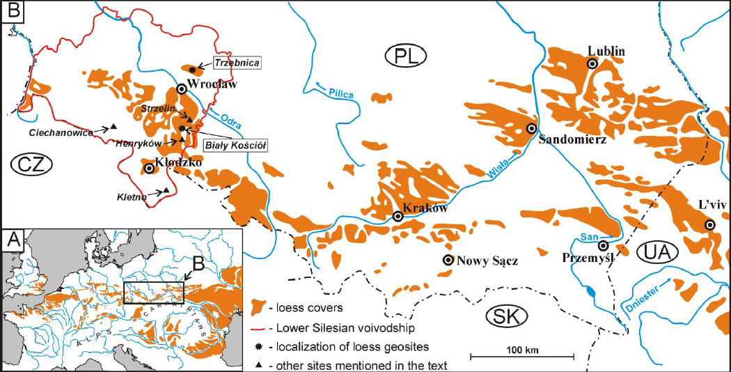
A – Map of loess distribution in Europe; B - Location of all Lower Silesian loess geosites and other sites mentioned in the text on the background of loess distribution in Poland (acc. 31 - modified).
Although the most important loess sections have been described in recent scientific literature [30, 31, 32, 33, 34, 35], the Lower Silesian loess issue and loess areas are still not popular and appreciated by geotourists [13, 29]. The question is: could they provide interpretative facilities and services not only for geoscientists and students but also for conscious tourists? Would the loess documentary sites have an impact on the development of tourism potential of loess areas?
We chose these sections because they are well described in the geological literature and are still available to further research, presentation and discussions.
Both presented below loess-soil sections were investigated using advanced lithological methods. Grain size, low-field magnetic susceptibility (MS), carbonate content (CC) and total organic carbon analyses were conducted. The chronology of the sections was established by OSL and radiocarbon methods.
2.1 The documentary site "Loess of Vine Mountain" in Trzebnica
Already existing documentary site "Loess of Vine Mountain" (51∘18’44.45 N, 17∘4’14.68 E, 192.5 m a.s.l.) was established 23rd of December 2016. It is located in an old clay pit in NE part of the Trzebnica city, ca. 25 km north of Wrocław (Figure 2). Geosite is located in the area of Trzebnica Hills, which is a mesoregion of Silesian Rampart [36].
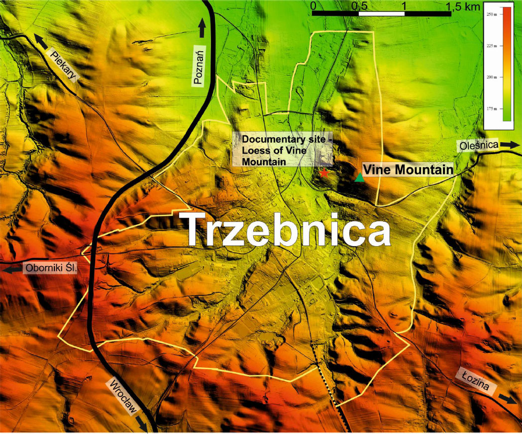
Location of documentary site "Loess of Vine Mountain" in Trzebnica on the background of digital elevation model.
The protected vertical loess wall is situated in the southern portion of the quarry. The Late Pleistocene loess sequence is 6 m high and 50 m long (Figure 3). The loess and loess derived sediments cover stony pavement, where Lower Palaeolithic artefacts have been found in 1980s [19, 37, 38]. In some parts of the exposure loess was deposited directly on Pliocene clay.
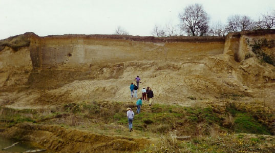
Southern loess wall within the excavation of the Trzebnica brickyard in the 90s of the last century –the place of the present documentary site "Loess of Vine Mountain" (photo: Z. Jary).
The main goal of establishing this documentary site is to preserve the sequence of sedimentary rocks of several
geological formations and environments occurring in the superposition [20, 39]:
– Neogene (Pliocene) clay deposited in alluviallacustrine environment, deformed in the upper part
![Figure 4 The contact zone between loess and Neogene clay in the southern wall of Trzebnica quarry [20]. 1- Neogene clay; 2- sandy layers; 3- gravelly layers; 4- big gravel bodies; 5- single big stones; 6- till; 7- massif loess; 8- laminated loess; 9- clay laminas; 10- flow structures in loess; 11- sandy laminas in loess; 12- iron structures.](/document/doi/10.1515/geo-2018-0052/asset/graphic/j_geo-2018-0052_fig_004.jpg) Figure 4
Figure 4The contact zone between loess and Neogene clay in the southern wall of Trzebnica quarry [20]. 1- Neogene clay; 2- sandy layers; 3- gravelly layers; 4- big gravel bodies; 5- single big stones; 6- till; 7- massif loess; 8- laminated loess; 9- clay laminas; 10- flow structures in loess; 11- sandy laminas in loess; 12- iron structures.
– residual Mesopleistocene morainic pavement with Scandinavian erratics strongly deformed mainly in periglacial environment;
– Pleniweichselian loess sequence with initial tundragley soils, roots horizons and ice wedge casts
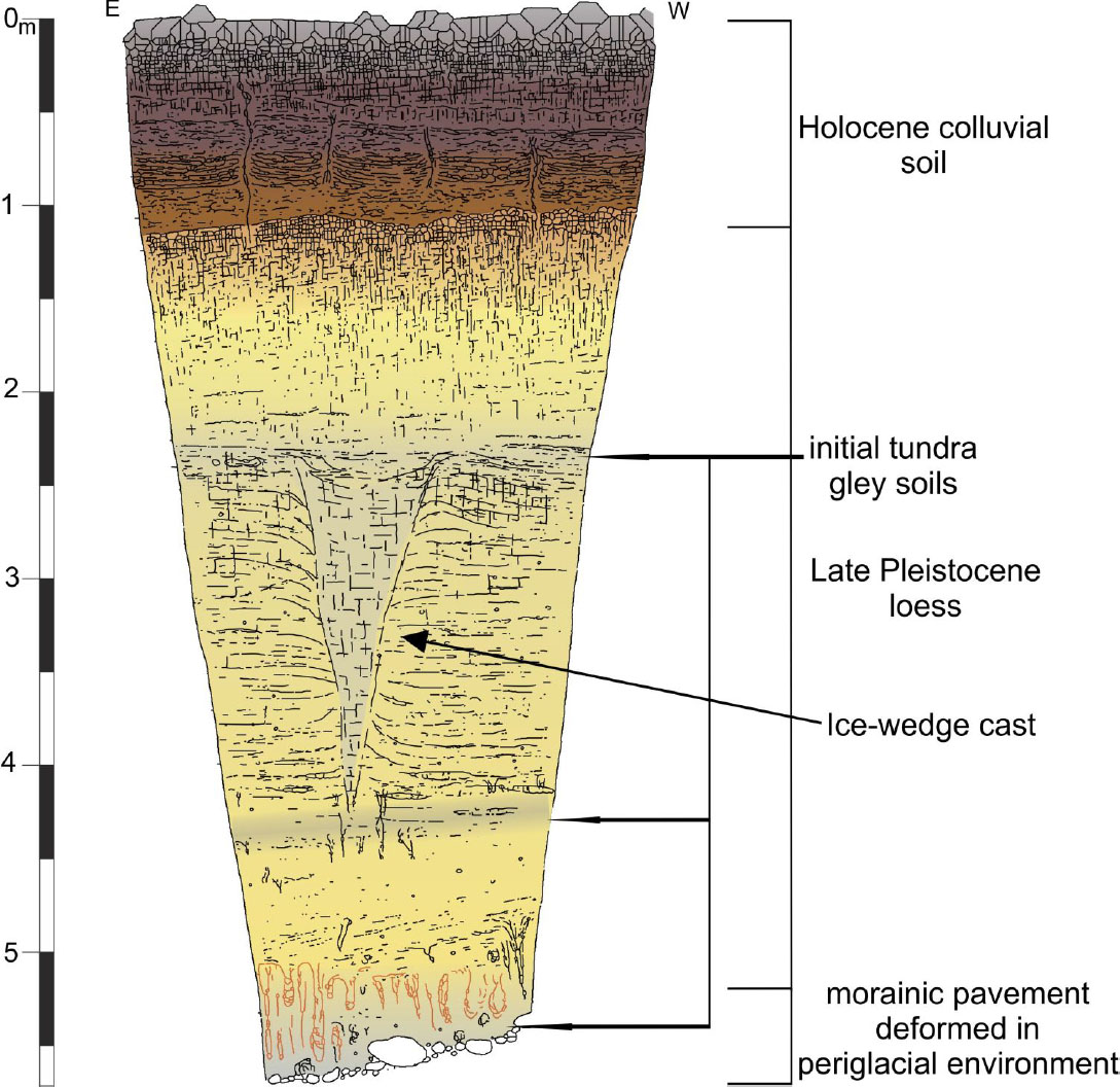 Figure 5
Late Pleistocene loess sequence in Trzebnica quarry (central part of wall shown on figure 3) with initial tundra-gley soils, roots horizons and ice wedge cast. Pleistocene morainic pavement in the floor and colluvial soils in the upper part (20 - modified).
– Holocene colluvial soils.
There are no doubts that this site is of great importance due to its scientific and didactic qualities. However, its special attractiveness for geotourism purposes should be primarily exposed. Taking into account aesthetic and educational values as a principal for potential geotourists the following geo-features of the documentary site "Loess of Vine Mountain" could be offered (Table 2).
Geotourist attractiveness of the documentary site "Loess of Vine Mountain".
| Geotourist elements | Educational value to promote |
|---|---|
| Sequence of different-age sedimentary rocks,lithologically and genetically diverse: Neogene clay, Pleistocene morainic pavement with artefacts, Late Pleistocene loess, Holocene colluvial soils | Geological time-scale; global and regional climate changes; Ice Age - evidence of former glaciations; artefacts; lithological differentiation; Loess – aeolian quartz silt deposited in periglacial zone; soil erosion caused by agriculture |
| Ice-wedge cast | Global and regional short-term, abrupt climate changes – the proof of former occurrence and disappearance of permafrost |
| Tundra-gley and boggy soils within Late Pleistocene loess | Global and regional short-term climate changes – stable and unstable periods of soil development |
In this excavation periglacial structures left after former ice wedges which are the effect of global climate changes deserve special attention – they are proof of the occurrence and disappearance of permafrost in this area. In that time the annual mean temperature were 10-15 °C lower than nowadays [32, 33].
2.2 “Loess-soil sequence in Biały Kościół” – planned loess documentary site in Strzelin Hills
The loess-soil section Biały Kościół is located in an old clay pit, several meters from the road connecting Strzelin and Henryków (λ = 17∘01’30”E, φ = 50∘43’30”N;(Figure 6).The loess profile is placed on the west slope of the Oława valley at an altitude of approximately 185 m.a.s.l. Site is located in the area of Strzelin Hills. The profile location itself is a great asset for planned documentary site. The sequence is situated only 50 m from the voivodship road No. 395. So, reaching this geosite should not be a problem for the potential tourists.

Location of loess-soil section in Biały Kościół on the background of a digital elevation model.
The loess cover in the Strzelin Hills was previously described by Raczkowski [14, 40]. The thickness of loess cover is considerable but very differentiated - from 0 to 15 m. There are typical forms of loess relief: gredas, dry valleys, gullies and closed depressions.
Due to its unique succession, comparable to the typical Late Pleistocene sequences of European Loess Belt, the section in Biały Kościół was presented during several consecutive Loess Seminars organized by the University of Wroclaw [42, 43, 44, 45, 46].
Biały Kościół loess-soil sequence (9 m high) consists of five basic lithopedostratigraphic units (Figure 7) developed during the Late Pleistocene and Holocene: two polygenetic fossil pedocomplexes, two calcareous loess units and modern soil in the top.
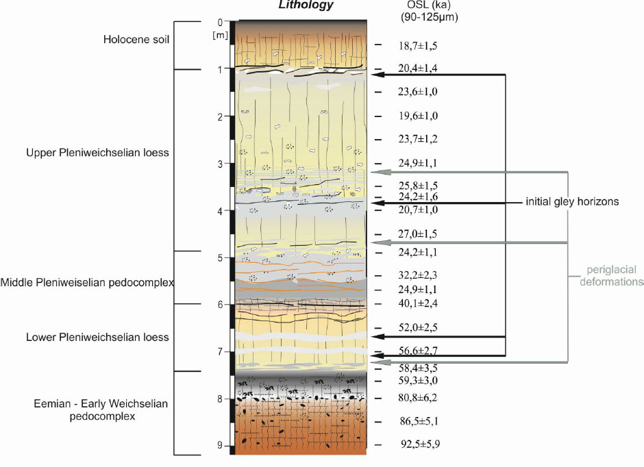
Late Pleistocene loess–palaeosol profile in Biały Kościół with OSL (Optically Stimulated Luminescence) dating results obtained for coarse quartz grain (90-125 μm; after 35).
The most important scientific value of the Biały Kościół loess sequence (Figure 7 and 8A,B,C) is very well preserved pedosedimentary record of Late Pleistocene climate changes occurring in the superposition within vertical wall of 9 m high [34, 35, 43, 44, 45, 46, 47]:
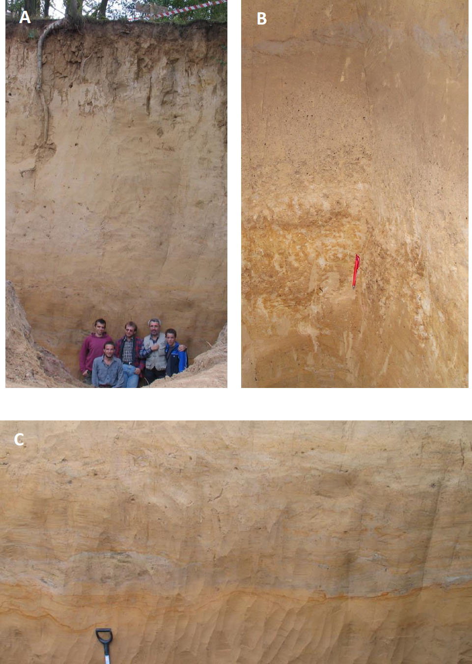
Loess section in Biały Kościół. A – The Upper Pleniweichselian loess with Holocene brown soil in the upper part; B - Eemian and Early Weichselian pedocomplex; C - Middle Pleniweichselian pedocomplex (photos: Z. Jary).
– Eemian and Early Weichselian set of fossil forest soils (pedocomplex) gleyed and deformed by gelifluction in the upper part (Figure 8B;
– Lower Pleniweichselian carbonate loess with initial gley horizons;
– Middle Pleniweichselian set of tundra-gley soils (pedocomplex) with permafrost features, deformed by gelifluction and frost heave (Figure 8C);
– Upper Pleniweichselian carbonate loess with initial gley horizons (Figure 8A);
– Holocene brown soil (Figure 8A)
From the point of view of potential geotourists and taking into account the aesthetic and educational values of Biały Kościół loess site the following geo-features of this site could be highlighted (Table 3):
Geotourist attractiveness of the planned documentary site “Loess-soil sequence in Biały Kościół”.
| Geotourist elements | Educational value to promote |
|---|---|
| Sequence of the Late Pleistocene loess and soil horizons | Climate changes during the last Interglacial-Glacial cycle. Loess – aeolian quartz silt deposited in periglacial zone |
| Frost heave and gelifluction structures | Regional short-term, abrupt climate changes – the proof of stable and unstable climate |
| Interglacial and interstadial pedocomplexes, initial gley soils within Late Pleistocene loess | Global and regional climate changes of varying intensity and duration |
Biały Kościół loess profile is situated relatively far from Strzelin city (7 km) in the middle of agriculturally used field thus difficult to control and preserved. But this may change in the near future. There is still a lot to be done in order to prepare Biały Kościół site to become a proper documentary site but with help of local authorities and scientists it seems to be possible. Same as in the other cases well exposed loess profiles may become an interesting offer for the new generation of geotourists [e.g. 15, 16, 48]. There is a constantly expanding group of tourists who willingly discovery the mysteries of the Quaternary epoch recorded at the loess sequences. Of course, it requires a special ways of presentation. The most important thing is to “translate” the scientific results into the language of ordinary recipients using the latest techniques.
3 Tourist potential and risk of loess documentary sites
The tourist potential of the described region, although the loess forms are unique, is relatively unappreciated. It is rather difficult to say that tourist traffic would be significant. However, if you take into account the wider context - the situation could change. Both documentary sites, the existing and the proposed one, are situated in an interesting and culturally attractive environment. Presented below are cultural attractions of national and even international rank that generate tourism. Documentary sites can be an important and attractive complementary element, enriching the tourist offer of the region. In this context, the relation to the cultural heritage elements is an opportunity for the existence of loess (with its educational richness) in the consciousness of tourists, even those who are not necessarily knowledgeable of the abiotic environment. In addition to the opportunity of the cultural environment it should also be pointed to threats that may be associated with the functioning of documentary sites in the tourist region. The most important ones were also presented and commented on.
3.1 Cultural heritage and its influence on tourist movement in the vicinity of loess documentary sites
Loess areas in the Lower Silesia are usually accompanied by the rich cultural heritage. They are associated not only with historical times but also with prehistory. The archeological sites represent different cultures throughout the history of human activity, although their potential for tourism development is almost unused. The Lower Paleolithic settlement, the oldest traces of human occupation in Poland, was found on the western slope of Vine Mountain in Trzebnica [19, 37]. Rich in archaeological sites is also an area in the vicinity of Biały Kościół loess site.Among the numerous sites, the open-air site in Henryków dating back on the Early Gravettian age (28.5 - 31.5 ka BP) deserves attention [49]. However, the greatest value, from the tourism development point of view, of this area there are the historical monuments. The documentary sites in Trzebnica and Biały Kościół could be an excellent complement for tourists visiting well-known medieval monasteries [50]. Around 8 km south of the Biały Kościół loess site the Cistercian Monastery in Henryków is located (Figure 9A) It was mentioned for the first time in documents from 1222, when the Duke Henry I the Bearded gave his permission to found a branch of the Cistercian here. The abbey is also important for Polish history [51]. A Latin chronicle „The Book of Henryków” compiled at Henryków abbey in the 13th century contains the first known sentence written in Polish language [52]. The very precious Cistercian complex, both historically and architecturally, compresses: the Church of the Assumption of the Blessed Virgin Mary and the St. John the Baptist Church, dating back to the 13th century, the monastery, the farm buildings and surrounding park with centuries-old trees [53]. Just 7 kilometers north of the Biały Kościół there is Strzelin. Although the city was largely destroyed during World War II, some high-class monuments have been preserved. One of them is Romanesque St. Godehard’s Rotunda founded in the 11th century and rebuilt in the 13th century [53] (Figure 9B)
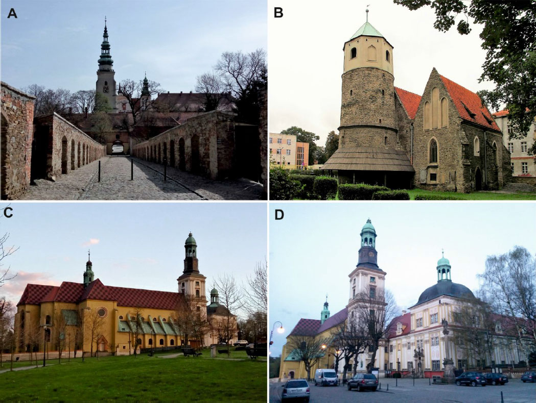
Cultural heritage located near the loess documentary sites: A - Cistercian Monastery in Henryków; B - Romanesque St. Godehard’s Rotunda in Strzelin; C,D - Sanctuary of St. Jadwiga in Trzebnica (photos: Z. Jary, P. Owczarek, W. Jary).
Trzebnica is also a town rich in historical monuments. In the proximity to the Trzebnica loess documentary site an important pilgrimage center is located. In 1202 the Silesian Piast duke Henry I the Bearded and his wife Saint Hedwig of Andechs founded here a Cistercian convent - the first in Poland, which is contemporary the Sanctuary of St. Jadwiga in Trzebnica (Figure 9C,D) The vast monastery complex consists of abbey church and residential buildings [54]. The church was built in the late Romanesque and Gothic style, to which baroque additions were made from 1741 [55]. The abbey also became a mausoleum of many rulers of the Lower Silesia. Currently, there are no information about loess documentary sites near these historic buildings, which are numerously visited by tourist and pilgrims. The authors see great potential in the geotourist development in these areas, among others, through comprehensive approaches and couplings of cultural tourism with geotourism.
However, the documentary site is potentially an excellent geotourist resource, but it is necessary to indicate the risks that may be brought by the tourist usage [48]. First of all, it should be emphasized its relatively low resistance to degradation compared to typical geotourist values. Soft rocks are easily damaged by erosion and the impact of mass movements (earthslide, mudslide) if they are not properly secured and used. Surface runoff, connected with rainfall or snowmelt, can affects the destruction of exposure by draining the top layer, which is not protected. Another element that may limit the development of tourism based on the discussed value is its temporary availability. The specificity of soft rocks makes it difficult to keep the loess wall constantly unchanged. Over time, its readability is blurred, and the outlay should be refreshed from time to time, which is associated with additional costs and the need for constant monitoring of the value. Another threat is the uncontrolled development of vegetation and destructive influence of roots. As a result, after some time the value will be illegible to the potential tourist, eventually it may also be destroyed. Another issue is the dangers arising from the incorrect use of land unveiling by the local community. It happens that the place situated on the sidelines of the locality becomes a place of illegal storage of garbage. This results not only in a significant decrease in the attractiveness of the asset, but even its destruction. A specific threat to this type of asset may also be the low level of awareness of the importance of this type of heritage for general knowledge about climate change over time. This may change, but it is associated with changes in the education process, especially for young people, which in the future may change the situation.
4 Conclusion
Documentary sites play an important role in many fields. First of all, they enable conducting field research and at the same time are a perfect presentation of their results. They also contribute to keeping the geological heritage unchanged. This is the case with the sites described above in Trzebnickie and Strzelińskie Hills, that are Quaternary palaeoclimatic and palaeoenvironmental archive. Both have a chance to become an important element, together with cultural heritage, on which to base the promotion of regions emphasizing their value for the development of geotourism. All this leads to an obvious conclusion: documentary sites are increasingly an important geotourist value. The increase in the popularity of geotourism among tourists can contribute to this, but without concrete actions the opportunity may remain unused. In order to achieve this, it is necessary to take action on at least three levels: education, management of assets by local authorities and technical adjustment for the tourist movement reception. In the first case, attention should be paid to presenting knowledge about the region among primary and secondary school students. Attention should be paid to the role of inanimate nature heritage in the development of the region, as well as its didactic and aesthetic attractiveness. A well-educated conscious inhabitant of the region or tourist will be an important element that will contribute to the popularization and protection of geotourist resources, including documentary sites. In the case of resource management, it is important to make the local decision-makers aware of the importance of the heritage presented in the documentary sites for the environment. Coordinated action of the scientific community and local associations should lead to emphasizing the role of an inanimate environment in planning documents, such as the tourism development strategy in the region. This should initiate a whole range of activities aimed at preserving and promoting the geological heritage. The technical side of adjusting the value to be perceived by tourists is also important. Described documentary sites, both in the case of Trzebnickie and Strzelińskie Hills are relatively sensitive to the pressure of tourist movement, hence the need for their appropriate adaptation. It should be equipped with the appropriate infrastructure such as:
– a marked trail leading to the value,
– protection against undesirable interference,
– systematic cleaning of plants,
– proper presentation of information related to the asset in the form of text, figures and photographs.
This way the attractiveness of this kind of resources for all tourists should increase. It is also very important to protect the loess documentary sites against the influence of weather conditions, like rainfall or snowmelt.
Summing up, it should be stated that also soft rocks can and should constitute an important element of the geotourist offer of the region, especially so rich in information related to the development of climate and environment in the Quaternary, as it is in the case of Lower Silesia. So far, three documentary sites are definitely not enough in relation to the potential presented by this one of the most important geotourist regions of the country.
References
[1] Hose T. A., Selling the Story of Britain’s Stone. Environmental Interpretation, 1995, 10-2, 16-17Search in Google Scholar
[2] Hose T. A., Towards a history of Geotourism: definitions, antecedents and the future. Geological Society, London, Special Publications, 2008, 300, 37-6010.1144/SP300.5Search in Google Scholar
[3] Hose T. A., 3G’s for Modern Geotourism. Geoheritage Journal, 2012, 4, 7-2410.1007/s12371-011-0052-ySearch in Google Scholar
[4] Wimbledon W. A. P., National site selection, a stop on the way to a European Geosite list. Geologica Balcanica, 1996, 26, 15-27Search in Google Scholar
[5] Council of Europe, Recommendation Rec (2004)3 on Conservation of the Geological Heritage and Areas of Special Geological Interest (adopted 5 May 2004). Committee of Ministers, Council of Europe, Strasbourg, 2004Search in Google Scholar
[6] Gray M., Geodiversity: Valuing and Conserving Abiotic Nature. John Wiley & Sons, Chichester, 2004Search in Google Scholar
[7] Dixon G., Geoconservation: an International Review and Strategy for Tasmania. Parks and Wildlife Service, Hobart, 1996Search in Google Scholar
[8] Erikstad L., History of Geoconservation in Europe. Geological Society, London, Special Publications, 2008, 300, 249-25610.1144/SP300.19Search in Google Scholar
[9] Hose T.A., The English Origins of Geotourism (as a Vehicle for Geoconservation) and Their Relevance to Current Studies. Acta Geographica Slovenica, 2011, 51-2, 343-36010.3986/AGS51302Search in Google Scholar
[10] Hose T. A., Geotourism in England: A Two-Region Case Study Analysis. Ph.D. thesis, University of Birmingham. Birmingham, 2003Search in Google Scholar
[11] Hose T. A., Geotourism: Appreciating the deep time of landscapes. In: Novelli M. (Ed.), Niche tourism; contemporary issues, trends and cases. Oxford: Elsevier Butterworth-Heinemann, 27-3710.1016/B978-0-7506-6133-1.50010-XSearch in Google Scholar
[12] Hose T.A., European Geotourism – Geological Interpretation and Geoconservation Promotion for Tourists. In: Barretino D., Wimbledon W.P., Gallego E. (Eds.), Geological heritage: its conservation and management. Instituto Tecnologico Geominero de Espana, Madrid, 127–146Search in Google Scholar
[13] Solarska A., Hose T.A., Vasiljević Dj.A., Mroczek P., Jary Z., Marković S.B., Widawski K., Geodiversity of the loess regions in Poland: Inventory, geoconservation issues, and geotourism potential. Quaternary International, 2013, 296, 68-8110.1016/j.quaint.2012.08.2057Search in Google Scholar
[14] Hose T.A., Presenting loess geotourism in the future: some considerations drawn from previous approaches to ‘hard’ and ‘soft’ rock geosites. In: Mimica-Dukić N. (Ed.), 1st International Conference on Geoheritage & Geotourism Research GEOTRENDS 2010, Novi Sad, Serbia. 73-74Search in Google Scholar
[15] Vasiljević D.A., Marković S.B., Hose T.A., Smalley I., O’Hara-Dhand K., Basarin B., Lukić T., Vujičić M.D., Loess Towards (Geo) Tourism – Proposed Application On Loess In Vojvodina Region (North Serbia). Acta Geographica Slovenica, 2011, 51-2, 390–40610.3986/AGS51305Search in Google Scholar
[16] Vasiljević D.A., Marković S.B., Hose T.A., Smalley I., Basarin B., Lazić L., Jović, G., The Introduction to Geoconservation of loess-palaeosol sequences in the Vojvodina region: Significant geoheritage of Serbia. Quaternary International, 2011, 240, 108-11610.1016/j.quaint.2010.07.008Search in Google Scholar
[17] The Act Of 16 April 2004 On The Protection Of Nature. Issued by the Sejm of Republic of Poland 16 April 2004, adopted 1 May 2004 by The Council of Ministers, Minister of the Environment and Minister of Finance,2004, Dz.U. no. 92, 880Search in Google Scholar
[18] Jahn A., Kozłowski S., Wiszniowska T., Jaskinia Niedźwiedzia w Kletnie. Badania i udostępnianie. [Niedźwiedzia Cave in Kletno. Research and sharing]. Ossolineum, Wrocław-Warszawa-Kraków-Gdańsk-Łodź, 1989 (in Polish)Search in Google Scholar
[19] Burdukiewicz J.M., Wyniki badań stanowiska dolnopaleolitycznego Trzebnica 2, woj. wrocławskie. [Research results of the Lower Paleolithic site Trzebnica 2, province Wrocław]. Śląskie Sprawozdania Archeologiczne, 1990, 31, 7-24 (in Polish)Search in Google Scholar
[20] Jary Z., Krzyszkowski D., Stratigraphy, properties and origin of loess in Trzebnica Brickyard, Southwestern Poland. Acta Universitatis Wratislaviensis, 1994, 1702, 63-83Search in Google Scholar
[21] Madziarz M., „Cuprifodina in Montibus” O historii i pozostałościach dawnych robót górniczych w rejonie Miedzianki – miasta zrodzonego i unicestwionego przez górnictwo ["Cuprifodina in Montibus" Old mining works history and relics near Miedzianka – city, which was created and destroyed by mining]. In: Zagożdżon P.P., Madziarz M, (Eds.), Dzieje górnictwa – element europejskiego dziedzictwa kultury, vol. 3, Wrocław, 2010 (in Polish)Search in Google Scholar
[22] Geikie J., The tundras and steppes of prehistoric Europe. Scot. Geogr. Mag. 1898, 14, 281-294, 346-35710.1080/00369229808733003Search in Google Scholar
[23] Tutkovsky P.A., K woprosu o sposobje obrazovanija lossa [The question of loess origin]. Zemlevedenie, 1899, 1-2, 213-311Search in Google Scholar
[24] Jahn A., Less, jego pochodzenie i związek z klimatem epoki lodowej [Loess, its origin and connection with the climate of the glacial epoch]. Acta Geologica Polonica, 1950, I(3), 257-310 (in Polish with English summary)Search in Google Scholar
[25] Maruszczak H., Charakterystyczne formy rzeźby obszarów lessowych Wyżyny Lubelskiej [Characteristic forms of relief on loess areas of the Lublin Upland]. Czasopismo Geograficzne, 1958, 29, 335-354 (in Polish)Search in Google Scholar
[26] Jary Z., Erozja wąwozowa na Wysoczyźnie Głubczyckiej [Gully erosion on Głubczyce Plateau]. Acta Univ. Wratisl.,1991, 1237, 131-151 (in Polish with English summary)Search in Google Scholar
[27] Leger M., Loess landforms. Quaternary International, 1990, 7, 53-6110.1016/1040-6182(90)90038-6Search in Google Scholar
[28] Kida J., Niektóre cechy rzeźby lessowej Opolszczyzny [Some features of the loess relief on the Opole region]. Acta Universitatis Wratislaviensis, 1996, 1808, 43-61 (in Polish with English summary)Search in Google Scholar
[29] Solarska A., Jary Z., Geoheritage and Geotourism Potential of the Strzelin Hills [Sudety Foreland, SW Poland], Geographica Pannonica, 2010, 14, 118–12510.5937/GeoPan1004118SSearch in Google Scholar
[30] Jary Z., Kida J., Śnihur M., Lessy i osady lessopochodne w południowo-zachodniej Polsce [Loess and loess-derived sediments in SW Poland]. Czasopismo Geograficzne, 2002, 73 (1-2), 63-100 (in Polish with English summary)Search in Google Scholar
[31] Jary Z., Zapis zmian klimatu w górnoplejstoceńskich sekwencjach lessowo-glebowych w Polsce i w zachodniej części Ukrainy [Record of Climate Changes in Upper Pleistocene loess-soil sequences in Poland and western part of Ukraine]. Treatise of the Institute of Geography and Regional Development of the University of Wrocław 1, 2007 (in Polish with English summary)Search in Google Scholar
[32] Jary Z., Periglacial markers within the Late Pleistocene loess-palaeosol sequences in Poland and western part of Ukraine. Quaternary International, 2009, 198, 124–13510.1016/j.quaint.2008.01.008Search in Google Scholar
[33] Jary Z., Loess-soil sequences as a source of climatic proxies: an example from SW Poland. Geologija, 2010, 52, 1-4 (69-72), 40-4510.2478/v10056-010-0004-2Search in Google Scholar
[34] Moska P., Adamiec G., Jary Z., OSL Dating and lithological characteristics of Loess deposits from Biały Kościół. Geochronometria, 2011, 38(2), 162–17110.2478/s13386-011-0013-xSearch in Google Scholar
[35] Moska P., Adamiec G., Jary Z., High resolution dating of loess profile from Biały Kościół, southwest Poland. Quaternary Geochronology, 2012, 10, 87–9310.1016/j.quageo.2012.04.003Search in Google Scholar
[36] Migoń P., Regiony fizycznogeograficzne [Physico-geographical regions]. In: Fabiszewski J. (Ed.), Przyroda Dolnego Śląska [Nature of Lower Silesia]. PAN, Wrocław, 2005 (in Polish)Search in Google Scholar
[37] Burdukiewicz J.M., Badania osadnictwa dolnopaleolitycznego w Trzebnicy [The investigations of the Lower Paleolithic settlement in Trzebnica], Śląskie Sprawozdania Archeologiczne, 1991, 32, 7-20 (in Polish)Search in Google Scholar
[38] Burdukiewicz J.M., Lower Palaeolithic sites with small artefacts in Poland. In: Burdukiewicz J.M., Ronen A., (Eds.), Lower palaeolithic small tools in Europe and the Levant. BAR S1115, 2003, 65-9210.30861/9781841714936Search in Google Scholar
[39] Krzyszkowski D., Pleistocene stratigraphy near Trzebnica, Silesian Rampart, Southwestern Poland. Bull. Pol. Acad. Sc. Earth, 1992, 40. 235–249Search in Google Scholar
[40] Raczkowski W., Less w okolicach Henrykowa na Dolnym Śląsku [Loess in the vicinity of Henryków in Lower Silesia]. Biuletyn Peryglacjalny, 1960, 7, 95-111 (in Polish with English summary)Search in Google Scholar
[41] Raczkowski W., Niektóre problemy genezy lessów Przedgórza Sudeckiego [Some problems of the origin of the Sudetic Foreland Loesses]. Biuletyn Instytutu Geologicznego, 1976, 297, 329-343 (in Polish with English summary)Search in Google Scholar
[42] Ciszek D., Jary Z., Kida J., Karamański P., Profil lessowy w Białym Kościele (Wzgórza Niemczańsko-Strzelińskie) [Loess profile in Biały Kościół (Niemcza-Strzelin Hills)]. In: Jary, Z. Kida, J. (Eds.), Pleistocene deposits of the Sudety foreland, XI Seminar „The stratigraphic correlation of loess and glacial deposits of Poland and Ukraine", Wrocław, 2001, 58–60 (in Polish)Search in Google Scholar
[43] Jary Z., Ciszek D., Kida J., Odsłonięcie lessów w Białym Kościele koło Strzelina [The loess-soil sequence at Biały Kościół]. In: Jary, Z. (Ed.), Record of climatic changes in loess successions. 4th Loess Seminar, Institute of Geography and Regional Development, University of Wrocław, 2004, 97–101 (in Polish with English summary)Search in Google Scholar
[44] Jary Z., Ciszek D., Kida J., Karamański P., Późnoplejstoceńska sekwencja lessowo-glebowa w Białym Kościele [Late Pleistocene loess sequence in the Biały Kościół]. In: Jary, Z. (Ed.), 5th Loess Seminar, XV Polish-Ukrainian Seminar, Record of environmental changes in Late Pleistocene loess- soil sequences. Wrocław, 2008, 2008, 35-36 (in Polish)Search in Google Scholar
[45] Jary Z., Ciszek D., Karamański P., Kida J., The loess-soil sequence at Biały Kościół – Niemcza-Strzelin Hills. In: Jary, Z. (Ed.), Closing the gap – North Carpathian loess traverse in the Eurasian loess belt, International Workshop, 6th Loess Seminar in Wrocław, Institute of Geography and Regional Development, University of Wrocław, 2011, 53–55Search in Google Scholar
[46] Jary Z., Ciszek D., Raczyk J., Moska P., Karamański P., Kida J., Korabiewski B., Biały Kościół: the key loess section of the Niemcza-Strzelin Hills. In: Jary, Z. &Mroczek, P. (Eds.): Kukla LOESSFEST ’14 - 7th Loess Seminar in Wrocław, International Conference on Loess Research in memoriam of George Kukla, Institute of Geography and Regional Development, University of Wrocław, 2014, 43–46Search in Google Scholar
[47] Skurzyński J., Jary Z., Raczyk J., Moska P., Krawczyk M., Stratigraphic and spatial aspects of the diversity of chemical composition of late Pleistocene loess-soil sequences in Poland: examples of profiles in Tyszowce and Biały Kościół, Acta Geographica Lodziensia, 2017, 106, 87-103 (in Polish with English summary)Search in Google Scholar
[48] Dong H., Song Y., Chen T., Zhao J., Yu L., Geoconservation and geotourism in Luochuan Loess National Geopark, China. Quaternary International 2014, 334–335, 40-5110.1016/j.quaint.2013.10.023Search in Google Scholar
[49] Wiśniewski A., Płonka T., Jary Z., Lisa L., Traczyk A., Kufel-Diakowska B., Raczyk J., Bajer A., The early Gravettian in a marginal area: New evidence from SW Poland. Quaternary International, 2015, 359–360, 131-15210.1016/j.quaint.2014.10.003Search in Google Scholar
[50] Rosik S., Najdawniejsze dzieje Dolnego Śląska (do roku 1138) [The earliest history of Lower Silesia (until 1138)], In: WrzesińskiW., (Ed.), Lower Silesia. Historical monograph, University of Wrocław, Wrocław, 2006, 15–54 (in Polish)Search in Google Scholar
[51] Wójcik M., Dolny Śląsk w latach 1138-1326 [Lower Silesia in the years 1138 – 1326], In: Wrzesiński W., (Ed.) Lower Silesia. Historical monograph. University of Wrocław, Wrocław, 2006, 55 – 105 (in Polish)Search in Google Scholar
[52] Wałkówski A., Sacred scripture of scriptoria of Cistercian monasteries in Lubiąż and Henryków until the end of the 13th century. In: Wyrwa, A.M., Dobosz J. (Eds.), Cistercians in the society of Central Europe. Poznań, 2000, 378–390 (in Polish)Search in Google Scholar
[53] Staffa M. (Ed.), Dictionary of tourist geography of Sudety, vol. 21, part1-2: Niemcza-Strzelin Hills, Paczkowskie Foreland, Wrocław, 2008 (in Polish)Search in Google Scholar
[54] Rozpędowski J., Abbey of the Cistercian ladies in Trzebnica, In: Strzelczyk J. (Ed.), History and culture of Cistercians in former Poland and their European relationships, Science Publishing UAM, Poznań, 1987, 263–281 (in Polish)Search in Google Scholar
[55] Stelmach B., Continuation of the history of Cistercian monastery in Trzebnica. In: Wyrwa A.M., Kiełbasa, A., Swastek J., (Eds.),Cistercians in the history and culture of Polish lands, the former Polish-Lithuanian Commonwealth and Central Europe, Poznań Publishing, 2004, 540–550 (in Polish)Search in Google Scholar
© 2018 Z. Jary et al., published by De Gruyter
This work is licensed under the Creative Commons Attribution-NonCommercial-NoDerivatives 4.0 License.
Articles in the same Issue
- Regular Articles
- Spatio-temporal monitoring of vegetation phenology in the dry sub-humid region of Nigeria using time series of AVHRR NDVI and TAMSAT datasets
- Water Quality, Sediment Characteristics and Benthic Status of the Razim-Sinoie Lagoon System, Romania
- Provenance analysis of the Late Triassic Yichuan Basin: constraints from zircon U-Pb geochronology
- Historical Delineation of Landscape Units Using Physical Geographic Characteristics and Land Use/Cover Change
- ‘Hardcastle Hollows’ in loess landforms: Closed depressions in aeolian landscapes – in a geoheritage context
- Geostatistical screening of flood events in the groundwater levels of the diverted inner delta of the Danube River: implications for river bed clogging
- Utilizing Integrated Prediction Error Filter Analysis (INPEFA) to divide base-level cycle of fan-deltas: A case study of the Triassic Baikouquan Formation in Mabei Slope Area, Mahu Depression, Junggar Basin, China
- Architecture and reservoir quality of low-permeable Eocene lacustrine turbidite sandstone from the Dongying Depression, East China
- Flow units classification for geostatisitical three-dimensional modeling of a non-marine sandstone reservoir: A case study from the Paleocene Funing Formation of the Gaoji Oilfield, east China
- Umbrisols at Lower Altitudes, Case Study from Borská lowland (Slovakia)
- Modelling habitats in karst landscape by integrating remote sensing and topography data
- Mineral Constituents and Kaolinite Crystallinity of the <2 μm Fraction of Cretaceous-Paleogene/Neogene Kaolins from Eastern Dahomey and Niger Delta Basins, Nigeria
- Construction of a dynamic arrival time coverage map for emergency medical services
- Characterizing Seismo-stratigraphic and Structural Framework of Late Cretaceous-Recent succession of offshore Indus Pakistan
- Geosite Assessment Using Three Different Methods; a Comparative Study of the Krupaja and the Žagubica Springs – Hydrological Heritage of Serbia
- Use of discriminated nondimensionalization in the search of universal solutions for 2-D rectangular and cylindrical consolidation problems
- Trying to underline geotourist profile of National park visitors: Case study of NP Fruška Gora, Serbia (Typology of potential geotourists at NP Fruška Gora)
- Fluid-rock interaction and dissolution of feldspar in the Upper Triassic Xujiahe tight sandstone, western Sichuan Basin, China
- Calcified microorganisms bloom in Furongian of the North China Platform: Evidence from Microbialitic-Bioherm in Qijiayu Section, Hebei
- Spatial predictive modeling of prehistoric sites in the Bohemian-Moravian Highlands based on graph similarity analysis
- Geotourism starts with accessible information: the Internet as a promotional tool for the georesources of Lower Silesia
- Models for evaluating craters morphology, relation of indentation hardness and uniaxial compressive strength via a flat-end indenter
- Geotourism in an urban space?
- The first loess map and related topics: contributions by twenty significant women loess scholars
- Modeling of stringer deformation and displacement in Ara salt after the end of salt tectonics
- A multi-criteria decision analysis with special reference to loess and archaeological sites in Serbia (Could geosciences and archaeology cohabitate?)
- Speleotourism in Slovenia: balancing between mass tourism and geoheritage protection
- Attractiveness of protected areas for geotourism purposes from the perspective of visitors: the example of Babiogórski National Park (Poland)
- Implementation of Heat Maps in Geographical Information System – Exploratory Study on Traffic Accident Data
- Mapping War Geoheritage: Recognising Geomorphological Traces of War
- Numerical limitations of the attainment of the orientation of geological planes
- Assessment of runoff nitrogen load reduction measures for agricultural catchments
- Awheel Along Europe’s Rivers: Geoarchaeological Trails for Cycling Geotourists
- Simulation of Carbon Isotope Excursion Events at the Permian-Triassic Boundary Based on GEOCARB
- Morphometry of lunette dunes in the Tirari Desert, South Australia
- Multi-spectral and Topographic Fusion for Automated Road Extraction
- Ground-motion prediction equation and site effect characterization for the central area of the Main Syncline, Upper Silesia Coal Basin, Poland
- Dilatancy as a measure of fracturing development in the process of rock damage
- Error-bounded and Number-bounded Approximate Spatial Query for Interactive Visualization
- The Significance of Megalithic Monuments in the Process of Place Identity Creation and in Tourism Development
- Analysis of landslide effects along a road located in the Carpathian flysch
- Lithological mapping of East Tianshan area using integrated data fused by Chinese GF-1 PAN and ASTER multi-spectral data
- Evaluating the CBM reservoirs using NMR logging data
- The trends in the main thalweg path of selected reaches of the Middle Vistula River, and their relationships to the geological structure of river channel zone
- Lithostratigraphic Classification Method Combining Optimal Texture Window Size Selection and Test Sample Purification Using Landsat 8 OLI Data
- Effect of the hydrothermal activity in the Lower Yangtze region on marine shale gas enrichment: A case study of Lower Cambrian and Upper Ordovician-Lower Silurian shales in Jiangye-1 well
- Modified flash flood potential index in order to estimate areas with predisposition to water accumulation
- Quantifying the scales of spatial variation in gravel beds using terrestrial and airborne laser scanning data
- The evaluation of geosites in the territory of National park „Kopaonik“(Serbia)
- Combining multi-proxy palaeoecology with natural and manipulative experiments — XLII International Moor Excursion to Northern Poland
- Dynamic Reclamation Methods for Subsidence Land in the Mining Area with High Underground Water Level
- Loess documentary sites and their potential for geotourism in Lower Silesia (Poland)
- Equipment selection based on two different fuzzy multi criteria decision making methods: Fuzzy TOPSIS and fuzzy VIKOR
- Land deformation associated with exploitation of groundwater in Changzhou City measured by COSMO-SkyMed and Sentinel-1A SAR data
- Gas Desorption of Low-Maturity Lacustrine Shales, Trassic Yanchang Formation, Ordos Basin, China
- Feasibility of applying viscous remanent magnetization (VRM) orientation in the study of palaeowind direction by loess magnetic fabric
- Sensitivity evaluation of Krakowiec clay based on time-dependent behavior
- Effect of limestone and dolomite tailings’ particle size on potentially toxic elements adsorption
- Diagenesis and rock properties of sandstones from the Stormberg Group, Karoo Supergroup in the Eastern Cape Province of South Africa
- Using cluster analysis methods for multivariate mapping of traffic accidents
- Geographic Process Modeling Based on Geographic Ontology
- Soil Disintegration Characteristics of Collapsed Walls and Influencing Factors in Southern China
- Evaluation of aquifer hydraulic characteristics using geoelectrical sounding, pumping and laboratory tests: A case study of Lokoja and Patti Formations, Southern Bida Basin, Nigeria
- Petrography, modal composition and tectonic provenance of some selected sandstones from the Molteno, Elliot and Clarens Formations, Karoo Supergroup, in the Eastern Cape Province, South Africa
- Deformation and Subsidence prediction on Surface of Yuzhou mined-out areas along Middle Route Project of South-to-North Water Diversion, China
- Abnormal open-hole natural gamma ray (GR) log in Baikouquan Formation of Xiazijie Fan-delta, Mahu Depression, Junggar Basin, China
- GIS based approach to analyze soil liquefaction and amplification: A case study in Eskisehir, Turkey
- Analysis of the Factors that Influence Diagenesis in the Terminal Fan Reservoir of Fuyu Oil Layer in the Southern Songliao Basin, Northeast China
- Gravity Structure around Mt. Pandan, Madiun, East Java, Indonesia and Its Relationship to 2016 Seismic Activity
- Simulation of cement raw material deposits using plurigaussian technique
- Application of the nanoindentation technique for the characterization of varved clay
- Verification of compressibility and consolidation parameters of varved clays from Radzymin (Central Poland) based on direct observations of settlements of road embankment
- An enthusiasm for loess: Leonard Horner in Bonn and Liu Tungsheng in Beijing
- Limit Support Pressure of Tunnel Face in Multi-Layer Soils Below River Considering Water Pressure
- Spatial-temporal variability of the fluctuation of water level in Poyang Lake basin, China
- Modeling of IDF curves for stormwater design in Makkah Al Mukarramah region, The Kingdom of Saudi Arabia