Attractiveness of protected areas for geotourism purposes from the perspective of visitors: the example of Babiogórski National Park (Poland)
-
Krzysztof Widawski
 ,
Zdzisław Jary
,
Zdzisław Jary

Abstract
This article examines the tourist role of protected areas important for their unanimated nature potential. In Poland the highest form of legal protection is a national park. Babiogórski National Parks is one of 23 national parks in Poland. The aim of this article is to present its tourist attraction based on its geotourist potential considered by tourists who visit this park. At the beginning a brief history of protection of Babia Góra is presented. Based on stock-taking sightseeing method an analysis of the most important tourist attractiveness elements (like infrastructure or tourist values) is done. The focus on the values of unanimated nature is made grouping them into four main categories. As the result of research on infrastructure the most important accommodation units were indicated present at the surroundings of this National Park which is vital for its tourist capacity. For the correct functioning of tourist movement at the protected area the supporting infrastructure is important bearing a lot of functions. The function of channeling of the tourist movement as well as the didactic function are the most important for protection and correct use of geotourist values. Among the many elements of the supporting infrastructure the most important ones are tourist and didactic routes (their course and themes are presented). The most important part of the article is the presentation of the participants of the tourist movement opinions on the Babiogórski National Park tourist attractiveness. A survey was conducted and then analysed on 308 respondents in 2011. They were asked to judge both the quality of infrastructure as well as attraction of geotourist values together with their adaptation to reception by the tourist movement. The results analysis served as a base to appraise the state and perspectives for the geotourism development in Babiogórski National Park from the point of view of the receivers of tourist product i.e. the protected area.
1 Introduction
It is not surprising that protected areas and tourism combines a long tradition of the mutual coexistence [1]. The region that protects the nature, also inanimate nature, is at the same time a set of tourist resources unique in its character. This can also serve as a base for the creation of the tourist product attractive both didactically and aesthetically. This value has been noticed long ago and in the last two decades it has significantly increased. For years the natural environment had its privileged position in the ecotourism or green tourism. It grows out of the sustainable development concept – a wider idea where nature is the main element to which all others like tourist infrastructure and accessibility is subordinated. The role of tourism in the natural heritage protection is emphasized by many authors [1, 2, 3, 4, 5, 6] although at the same time the threats resulting from the human presence in the protected areas are stressed [7]. Two further issues are considered: resilience of the natural resources and knowledge combined with appropriate education. The interaction between these two factors reinforces the security of the natural resources [8]. It is important that the effects of ecological education, necessary to preserve nature in its unchanged form, were visible in many fields. It is not just the increased awareness of tourists and the local community, which is underlined by Bookbinder [9] or Valentine [10].
The specific activities related to the organization of tourist flow on the protected areas are also crucial. Ayoo [11] points out the importance of the appropriate attitude of the local community in using the resources of inanimate nature. If they develop the need to protect the natural resources and use them in a sustainable way they can use them for long [12]. It is often emphasized that success in tourism with the use of natural resources is also based on the appropriate level of services, high quality of the environment [13, 14] and the proper protection of its resources. The role of transport should also be pointed [15] together with the accommodation and other facilities for the persons visiting the protected areas [16]. Each element can affect the interest of tourists [17]. However, poorly planned infrastructure could stop the spread of tourism and, what is worse, it can destroy the natural resources thus the entire region may lose [18]. The sustainable approach in tourism in the protected areas is the subject of many studies conducted in the world [19, 20]. Conducting such research would help to maintain better control over the tourist activity and its development and all parties using this in the region [21]. Cooperation with the local community is perceived as an indispensable element of preserving nature in the unchanged form [22, 23]. Guyer and Pollard [24] emphasize that tourism in the protected areas should be managed with the help of the local actors from the region, with particular emphasis on the local community including people living in marginal areas for whom the tourism is a real chance to change the fate.
The development of tourism in the protected areas along with an increase in the ecological awareness and the specialization of the tourist’s preferences must have brought a new, dynamic and growing form of tourism – geotourism. One of the very first definitions then developed has been proposed by Hose [4, 25, 26, 27, 28] pointing that this form of tourism is “the provision of interpretive and service facilities enabling tourists to acquire knowledge and understanding of the geology and geomorphology of a site (including its contribution to the development of the Earth sciences) beyond the level of mere aesthetic appreciation”. Newsome and Dowling [29] define geotourism as a kind of sustainable tourism, which focuses on the experience of the geological elements of the Earth on a way that helps to appreciate its environmental value together with appreciation of the need to protect on one hand and the economic need of the local community on the other hand. Geotourism is followed by its flagship product: geopark – defined by UNESCO [30] ”as a nationally protected area that contains a number of geological heritage sites of particular importance, rarity or aesthetic appeal, and is one element in an integrated concept of protection, education and sustainable development.”
Protected areas like national parks (often achieving the status of a geopark) have been a special attraction for tourists for a long time. With the increase of mobility, education and leisure, their tourism usage has dramatically increased in the last two decades [31]. The majority of the protected areas deal on the one hand with conservation of the natural resources and on the other hand provide the opportunities for the development of recreation and tourism. To meet the need the national park managers are looking for information about the visitors and the type of experience they seek. It is important that (armed with this knowledge) they can maintain high quality of the resource - interesting and thus providing income for areas that need to be protected [7].
The postulate of the research on tourism needs in connection with tourism resources and regions is not new [7, 24, 32]. Such knowledge is helpful when creating a suitable product that takes into account the requirements of both parties: the tourists and the nature of the protected area [33, 34]. It is worth asking the question of how the protected area is prepared for the reception of the tourist flow and how the tourist product is perceived by tourists using it. This article is based on the data collected from visitors to the Babiogórski National Park.
2 Aims and methodology
The hypothesis in this article boils down to the statement that protected areas with their proper development, are attractive for tourists visiting them. In order to check this the analysis of the tourist attractiveness elements like infrastructure or tourist resources has to be done. For this purpose stock-taking sightseeing method was used. The next step is to examine the opinions on the tourist attractiveness of geotourists visiting the Babiogórski National Park. For this article the analysis was made of those elements that refer directly to the Park (both resources and infrastructure), which affect the tourist attractiveness. The survey was conducted on 308 respondents in the tourist season of 2011. The research was carried out in four periods that are usually characterized by increased tourist traffic:
The first long weekend (a long weekend is an accumulation of holidays associated with public holidays on working days and weekends): in 2011 it fell between April 28 and May 5. During that period the tourist traffic is usually increased but despite 9 free days only 66 surveys were collected. Such a low turnout was the result of adverse weather conditions - snow and rain, fog and a relatively strong wind made it difficult to visit, thanks to which few tourists, staying in the vicinity of the Park, decided to go on a mountain trip.
Mid-June (weekend 11 – 12 June) - the pre-holiday period; the majority of visitors are young people and school groups. Thanks to excellent weather conditions, 72 questionnaires were correctly completed.
Long weekend from 15 to 17 August. Thanks to good weather conditions and the accumulation of long-term tourist traffic and weekend trips, 30% of all surveys (94) were obtained.
The first half of September (5 – 7.09.2011), mainly individual tourists, usually university students as it was still free-of-studies time for them.
Each time tourists or visitors were asked to judge both the quality of infrastructure as well as attractiveness of geotourist values together with their adaptation to reception by the tourist movement.
3 Discussion and results
3.1 Babiogórski National Park – geomorphological approach
Babiogórski National Park is located within the Western Beskids (Outer Western Carpathians) forming the westernmost part of the Carpathian arch. It covers the highest elevation of this part of the mountains with Babia Góra peak (1725 m. a.s.l.) Babia Góra is built from flysch of the Cretaceous and Paleogene ages [35]. The flysch creates a complex of conglomerates, sandstones, siltstones and claystones of variable thickness, which sedimentation took place from the Upper Cretaceous to the Early Miocene [36]. The folding and uplift of this formation occurred in the Neogene during alpine orogeny. Tectonic movements in this part of the Carpathians gave rise to large tectonic units – nappes, which were overthrust from the south to the north [37, 36]. The largest and innermost unit of the Outer Carpathians is the Magura nappe. In addition to this unit, it can also be distinguished: Fore-Magura-Dukla group, Silesian, Sub-Silesian, Skole and Boryslav-Pokuttya nappes [35]. Rock complexes building the culmination of Babia Góra belong to the Magura nappe, which is mainly coarse sandstones. Babia Góra is a highly elevated range of about 10 km, elevated almost 1000 m above the surrounding valleys. It has a clearly asymmetric shape. The northern slopes are precipitous, with numerous rock outcrops, slips and landslide landslides, while the southern slopes are gently sloping, referring to the fall of the Magura sandstones. In the relief of Babia Góra, a number of elements can be distinguished, which make it unique in the scale of entire Western Carpathians. Within the narrow ridge parts there are extensive rock debris formed during the cold periods of the Pleistocene. Within the ridge of the northern slopes at an altitude of 1350 – 1700 m, there are different-shaped landslide forms modeled by rubble runoffs [38]. Glacial forms have been fragmentarily preserved being a result of local glaciation or the influence of the patches of long-lasting snow [39, 40]. The depressions of landslide niches often fill the so-called waters “little pounds” (e.g. Wet Little Pound). These steep northern slopes pass into gentle slopes of the main ridge cut by numerous V-shaped valleys.
In terms of climate, the Western Carpathians belong to the Carpathian region of temperate, transitional climate [41]. Here, there is a spatial diversity of climatic relations characteristic for mountain areas mainly related to the height above the sea level [42]. The amount of precipitation depends on the height above sea level and location in the Carpathian chain. Babia Góra receives approx. 1475 mm [43]. In the course of the year the maximum rainfall falls on the summer half-year. The snow cover appears in mid-October and thaws from the end of March till the end of May [44, 43, 41]. At Babia Góra it is best in the Western Beskids to develop climatic floors which in height are convergent with plant levels. The original vegetation of the low-lying floor (about 550 - 1150 m above sea level) is Carpathian beech forest (Fagetum carpaticum) and in places spruce or fir-spruce forests [45]. The upper rack extends from 1150 to 1390 m above sea level. The dominant collection here is the Carpathian spruce forest (Piceetum excelse carpaticum). Above the forest border stretches the mountain pine (Pinetum mughi carpaticum)(1360 – 1650 m a.s.l.) and Alpine floor (1650 – 1725 m a.s.l.) [46]. Currently forest complexes especially the lower floors are replaced by artificial spruce cultures or through hay meadows, pastures and arable.
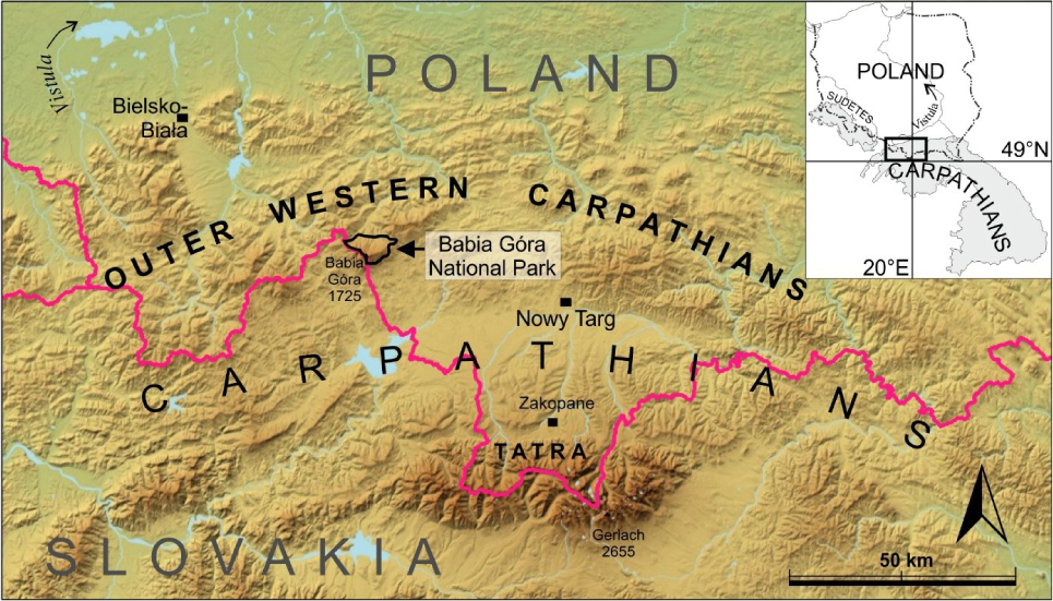
Location of the Babiogórski National Park within the Carpathian arch
3.2 Babiogórski National Park as a protected area
The necessity to protect the nature including its inanimate form has been noticed in Poland long time ago already. It is expressed in a multitude of forms of protection. Among the surface forms of the environmental protection one can enumerate: nature reserves, landscape parks, protected landscape area, nature 2000 area – implementing the policy of the protecting the areas in European Union, or finally – national parks, the most important form of the surface protection of the nature in the country. Its functioning is regulated by the highest (next to the constitution) legal act – National Protection Act – number 92, from 16 April 2004. National Park according to the above mentioned Act is defined as an area distinguished by its natural, scientific, social, cultural and educational values of the surface up to 1000 hectares where all the nature and landscape values are protected. The National Park is created “to preserve the biodiversity, resources, the components of inanimate nature and landscape values and to restore the proper state of the resources and components of nature…”. The crucial in the context of sustainable use of the protected area resources is the article number 12 introduced in 2012 which emphasizes the fact that “the area of the national park can be available in a way that will not adversely affect nature in the national park [47]”.
The current state of protection clearly indicates the need for such management of the unique resources so that they can remain attractive also for the future generations. Although it is obvious now the awareness of the need to protect the inanimate nature in this area was present almost a century ago. The first postulates and specific actions appeared in the second decade of 20th century. As a result a reserve in the higher part of the massive in 1928 was created. Until 1933 the protected area covered 1045 hectares of land of the high-mountain, sub-alpine and alpine level. After the WWII the idea of enlargement of the protected area re-appeared. In 1954, October 30 the Babiogórski National Park was created (Dz. U. Nr 4, poz. 24 and 25). In 1997 park was enlarged again and now (together with the buffer zone) it occupies 11828.55 hectares. In the justification to the establishing of the National Park elements the following elements were considered among others: the significance of the relief (its relative altitude exceeds within the Park 1050 m.) and is one of the highest in the Polish mountains, landslide pounds (unique in the Beskidy Mountain Range) and finally the endemic plants. It is worth mentioning the rank of the park – in 1977 Babiogórski National Park got the status of the UNESCO Biosphere Reserve as one of the first of its kind in Poland.
Natural resources of Babiogórski National Park
| Kind of resource | Resource |
|---|---|
| Water resources | Mokry Stawek, Głodna Woda |
| Rocks | Borsucze Skały, Diablak, Piarżysty Żleb, Świstowe Rocks, Wołowe Rocks |
| Viewpoints | Diablak, Wołowe Skałki, Kepa, Mała Babia Góra, Sokolica |
| Others | Gruba Jodła, Babiogórski region plant’s garden |
3.3 Development of tourism and tourist resources of Babiogórski National Park
Although located far from the most popular tourist routes like for example Tatra Mountain Range, Babia Góra massif was also a destination for the tourist trips starting from the 18th century. The result of the increasing popularity was the visit of Archduke Józef Habsburg in 1806 [48]. The first tourist routes appeared in the last decade of the 19th century. Ten years later a need for a permanent accommodation base appeared so two shelters were built [49]. An impetus in the development of tourism was the new communication accessibility in 1968 of the Lipnicka Pass which significantly shortened the time of entering the peak.
The Tourist attractiveness of the region mainly depends on the natural tourist resources. Among the most attractive ones it is mentioned: Mokry Pound or “Głodna Woda” sources, rocks and the rock complexes, viewpoints or the elements of the animate nature.
Among the inanimate nature resources the noteworthy are the rocks made of Masurian granite found in the highest parts of the massif. The largest cluster is located around the peak. Smaller fragments of rocks form vast rocky debris around the peak like in case of Piarżysty couloir, Treasure Hunters’ Couloir or The Wide Couloir.
The quite interesting offer that promotes the uniqueness of the regions’ nature is the museum of Babiogórski National Park and the Babia Góra massif plants garden. The museum also functions as an educational center of the park.
3.4 Tourist infrastructure of Babiogórski National Park
Within the park there is only one accommodation unit – shelter in the clearing Markowe Szczawiany. After two years of renovation it was re-opened in 2009 and it offers 38 places in two, three, five and seven-bed rooms. Restrictions of the capacity of the accommodation units in the park are justified since according to the postulate presented in the Polish literature [50] within the national park there shouldn’t be any facilities including accommodation, gastronomy nor communication bases outside the tourist routes, and only exceptionally (where it is justified with the real needs of tourism) individual shelters can be located inside the park.
Accommodation base which makes easy to explore the national park is concentrated in the neighbouring communities. In total the capacity of the three communities: Zawoja, Jabłonka and Lipnica Wielka reaches 3776 beds. Most of the places belong to houses (agritourism or guest rooms) and holiday resorts (together 1501 beds). It is worth emphasizing the upward trend of the development of a small-scale accommodation base among which the most important is agritourism. In 80 units 1109 tourists can be accommodated. Such trend is very important in the context of sustainable development of tourism: a scattered, small-scale accommodation base harms the natural environment in the least possible way.
The key to the proper functioning of tourism in the area of the National Park is the complementary base for tourist flow. Its role cannot be overestimated both in the correct implementation of the educational process (which is one of the important goals that are set for the park management) as well as in the correct channeling of tourist flow so as to minimize the changes in the park’s biotopes.
It is worth paying attention to the fact that in the park area there are only the necessary elements of the tourist infrastructure including the tourist information points. All of them are located at the entrance to the park. They are available all season long from May to October. The same applies to the rain shelters and parking lots. The cohesion of the park infrastructure and the needs related to the protection of valuable natural resources is also indicated in the development strategy. Arcikiewicz [51] emphasizes that Babiogórski National Park has sufficient infrastructure to handle tourist flow, hence no further expansion is planned but only modernization (taking into account the need to eliminate the negative impact on Babia Góra massif nature which is the priority).
Complementary base in Babiogórski National Park
| Elements of the complementary base | Quantity; ubication, |
|---|---|
| Rain shelters | 11 |
| Tourist information points | 3; Zawoja Markowa, Lipnicka Pass, Przywarówka |
| Focal and educational circles | 3; Zawoja M., Policzne, Przywarówka |
| Viewpoints | 2; II serpentyna, Sokolica |
| Parking | 3; Zawoja Markowa, Lipnicka Pass, II serpentyna |
| Seasonal wc in the summer | 3; Zawoja Markowa, Policzne, Lipnicka Pass |
| Garbage containers in the summer | 3; Zawoja M., Policzne, Przełęcz Lipnicka |
The appropriately arranged tourist routes are important for the proper distribution of the tourists in the area of the park. The total length of these routes is almost 53 km which is 1.56 km of the routes per 1 km2 of the park surface. They are not evenly distributed and as the consequence the tourist flow is not distributed evenly as well. In total within the park there are 17 tourist routes of the length of 200 km. The most common are hiking trails – 12. There are also three ski runs with the length from 1.5 km to 3 km, one horse trail – from Ochlipów to Przywarówka of the length of 2 km and finally one bike trail – from Zawoja Policzone to Rajsztag – 8 km long. There are only three separated cross country ski routes of a total length of 6.8 km. The horse trail enters the park boundaries only at the length of 2 km and most of it falls on the buffer zone. The same refers to the bike trail which was led around the outskirts of the park, along the provincial road 957, so it has a negligible impact on the Babia Góra massif nature.
One of the most important tools for raising the environmental awareness and the respect for the valuable natural resources are the educational paths – commonly used in the educational tourism. This is one of the simpler and at the same time the most effective and attractive way of bringing closer the meaning of establishing and functioning of the protected areas. Babiogórski National Park offers eight different educational paths each of which has a separate theme.
The vast majority of educational paths are devoted to the nature conservation (also inanimate). This especially applies to Rybi Potok valley where next to the presentations of the plants and animals of the area it is recommended to familiarize with the relief and the geological structure and the water phenomena of Babia Góra massif.
Educational paths in Babiogórski National Park
| Path’s name | Route | Leading theme | Number of stops | Length (km) |
|---|---|---|---|---|
| In the footsteps of Wawrzyniec Szkolnik | Zawoja Czatorża – Education center of BNP | Traditions of Babia Góra highlanders, costumes, art, traditional constructions | 5 | 2 |
| Echo of the primeval Carpathian wilderness | Loop starting from Zawoja Czatorża | Plant communities in the primeval Carpathian forest | 10 | 2.4 |
| How we protect Babia Góra nature | Loop starting from Zawoja Markowa | Ways and forms of nature conservation in BNP | 8 | 4.5 |
| Rybi Potok valley | Ryzowana – Rybna | Fauna and flora of Babia Góra massif | 8 | 2.9 |
| In the lower mountain zone of BNP | Rybna – Policzne | Plant communities of the lower mountain zone | 5 | 2 |
| At the source of Black Sea | Polana Krowiarki – Zubrzyca Górna | Hydrography of the area, shepherding and forest management, traditional constructions | 9 | 7 |
| From Zawoja through Diablak to Lipnica | Zawoja – Lipnica Wielka | Altitudional zonation of the vegetation of Babia Góra massif | 19 | 25 |
| Babia Góra with no boundaries | Markowe Szczawiny – Slana Voda | Nature and the shape of the slopes of Babia Góra massif | 15 | 12 |
The total length of these paths is 58 km and a significant number of the thematic stops allows tourists to get to know diverse elements of the local nature and culture practically every few hundred meters. It serves well both individual visitors and school groups which study during the field lessons the nature and its protection. At the same time it is worth emphasizing the course of these routes. Almost all of them were led along the edge of the National Park and its buffer zone. This is a deliberate procedure which is designed to relieve the center of the park from tourist traffic partly drained in this way on its outskirts contributing also to the protection of the park’s most valuable natural areas.
3.5 Natural resources and tourist services of Babiogórski National Park in the opinion of tourists
The first decade of 21st century shows an upward trend in the volume of the tourist flow. Between 2000 and 2011 the number of tourists has increased from 50.000 up to 75.000 visitors.
It is worth taking a look at the opinions of the tourists using the tourist offer of Babiogórski National Park. The survey conducted during the season 2011 indicates a growing awareness of the need to protect the nature. Among 308 respondents the vast majority (96%) were young people between 16 and 25 years old (32.5%) or of working age up to 65 years old (63.6%). More than half - 58.4% - were people of higher education usually more aware of the nature protection and sustainable development of the region than the rest of the community.
The main purpose of visit in Babiogórski National Park for the vast majority was a trip to the mountains that usually combines the need for active rest, aesthetic and cognitive experiences, which usually includes learning about nature both animate and inanimate of mountainous areas. Moreover, for the majority of people (87%) Babia Góra massif was the biggest attraction and was a leading cause of the tourist migration. Slightly more than 10% indicated the peak as a secondary target while visiting the region. It is worth noting the seemingly unimportant question about the assessment of the price of the park entrance ticket. In the case of this question the price itself does not matter so much (although it is equivalent to 1.20 euro) but the approach to the idea of an admission fee for the legally protected area is interesting. The majority – 84% - of the respondents found it adequate since they accept the need for financial support of the park authorities’ action aimed at nature conservation. This way they also support the development of the infrastructure accompanying the tourist flow which will finally lead to the optimization of the traffic reception with the protection mentioned above. This fact is very significant as the recognition of the need to co-finance by tourists of such park activities is an expression of increased awareness of the need to participate in the protection. Until the 90s of the 20th century it was not so obvious and the proposal of admission fees met resistance.
It is worthy to know the opinion about the elements of the tourist infrastructure such as the trails which channels the tourist flow in a valuable natural area. These elements are extremely important for maintaining the ecosystem in an unchanged state.
Again the majority of the respondents – 95.1% - highlights the fact that the trails are marked well or very well. This is important because trails are only possible ways to move around the protected area of the Park. Almost 90% of the respondents consider the proposed trails to be safe or rather safe. Just one person among 308 respondents thought the trails were definitely dangerous and four persons considered them rather dangerous (which makes 1.6% of the total number of respondents). There is no such unanimity as to the level of difficulty of the trails. For one-fifth of respondents they are very difficult or rather difficult. This share probably refers to the so called “Akademicka perć” - a trail that overcomes relative altitude of 500 m over a distance of 2.5 km. However already for almost half of the surveyed (45.8%) the routes are not difficult, which probably has an impact on the increase in the attractiveness of the tourist offer of the area in the group of people who treat hiking in mountain areas rather amateurishly.
The density and length of the trails were assessed very positively. 82.5% of people questioned on the trial considered this to be sufficient in this shape and 3.6% was of the opposite opinion, which confirms the right decision taken by the managers of the National Park to optimize access to the most important natural resources. The cleanliness of the trails was rated high – 85% of respondents were satisfied with the state of the routes, while 8.5% were dissatisfied with the functioning of this element of the tourist infrastructure.
An important aspect of tourist attractiveness is the tourists’ perception of natural values like rocks, water objects, views and panoramas or other elements encountered by them on the tourist trails. Of the total of 501 responses 60.3% found views and panoramas as the most attractive element which should not be surprising considering the mountainous landscape - one of the most attractive for tourist flow [52]. Every third answer pointed to rocks, especially rocks on Diablak peak and partly on “Akademicka Perć” trial. Less than 8% indicated water element. Among other responses, vegetation was indicated, however this resource was significant for less than 2% of responders.
It is also worth mentioning which elements of the tourist infrastructure are missing on the tourist trails. The most indications (50%) concerned the lack of garbage bins, which brings the problem of littering of the trails - not an easy one to be solved. In national parks garbage bins are usually avoided because it causes a problem of their successive emptying. In addition, they should be adequately protected from wild animals living in the park. The education of tourists to be responsible for their own trash is necessary here.
Every third answer postulated an increase in the number of places for resting (33.1%) especially in the central and dorsal zone of the park. Nevertheless, it would be difficult to fulfill because too much had to be interfered with the vegetation of the Alpine floor. However, it should be considered which would be more beneficial: the total absence of the recreation benches or wild campsites that possibly harm the vulnerable ecosystem. It is a postulate currently present in tourism and it refers to sustainable development, i.e. finding the right balance between nature and humans using natural resources.
4 Conclusions
Babiogórski National Park is one of the most valuable natural areas of Poland. It has valuable inanimate resources which are used for sightseeing or educational tourism. It is important to ensure proper tourist development of this protected area. All the activities should take into account the need for sustainable development. On the other hand resources should be made available in a limited way so that they would serve both the local community and the region’s visitors during the next decades. Hence specific infrastructure in the park: a dispersed accommodation base with limited capacity located outside the protected area and even more dispersed in the buffer zone. Complementary infrastructure that facilitates tourist the penetration of the Park is primarily tourist trails, viewpoints and car parks. The managers of the Park emphasized the educational nature of the Park’s resources by offering didactic paths that provide the most important geotouristic potential of the region. All these activities were fully appreciated by geotourists. They understand the need to protect and support the nature, appreciate geotouristic values and the way they are displayed. All this means that Babiogórski National Park can be considered an attractive geotourism area in the opinion of recipients of the offer and prospects for the development of geotourism in the Babia Góra massif in the context of sustainable development are promising.
References
[1] Bushell, R., Staiff, R., Eagles, P.F.J., 2007, ‘Tourism and protected areas: Benefits beyond boundaries’, in R. Bushell & P.J.F. Eagles (eds.), Tourism and protected area: Benefits beyond boundaries, pp. 1–11, CAB International, Wallingford10.1079/9780851990224.0001Search in Google Scholar
[2] Dowling RK, Newsome D., 2006, Geotourism: sustainability, impacts and management. Elsevier, Oxford10.4324/9780080455334Search in Google Scholar
[3] Honey M., 2008, Ecotourism and sustainable development: who own paradise? (2nd edn.). Island Press, Washington, DCSearch in Google Scholar
[4] Hose T. A., 1995, Selling the story of Britain’s stone. Environmental Interpretation 10:16–17Search in Google Scholar
[5] Panizza M., 2001, Geomorphosites: concepts, methods and example of geomorphological survey. Chinese Science Bulletin 46(Suppl.Bd.):4–610.1007/BF03187227Search in Google Scholar
[6] Słomka T, Kicińska-Świderska A (2004) Geoturystyka–podstawowe pojęcia. Geoturystyka 1:5–7Search in Google Scholar
[7] McCool, S.F., 2009, ‘Constructing partnerships for protected area tourism planning in an era of change and messiness’, Journal of Sustainable Tourism17(2), 133–148.10.1080/09669580802495733Search in Google Scholar
[8] Garavaglia V., G. Diolaiuti G., Smiraglia C., Pasquale V., Pelfini M., 2012, Evaluating Tourist Perception of Environmental Changes as a Contribution to Managing Natural Resources in Glacierized Areas: A Case Study of the Forni Glacier (Stelvio National Park, Italian Alps), Environmental Management 2012, 50: 1125 – 113810.1007/s00267-012-9948-9Search in Google Scholar
[9] Bookbinder MP, Dinerstein E, Rijal A, and Cauley H. Ecotourism’s support of biodiversity conservation. Conservation Biology 1998, 12:1399-1404.10.1111/j.1523-1739.1998.97229.xSearch in Google Scholar
[10] Valentine PS., 1992, Review: nature-based tourism. In: B. Weiler and C.M. Hall, editors. Special interest tourism, London: Belhaven Press; 1992, p.105-27Search in Google Scholar
[11] Ayoo C., Community-based natural resource management in Kenya, Management of Environmental Quality: An International Journal 2007, 18:531-41.10.1108/14777830710778292Search in Google Scholar
[12] Tonge J., Moore S., Importance-satisfaction analysis for marine-park hinterlands: A Western Australian case study, Tourism Management, 28, 2007, 768 – 77610.1016/j.tourman.2006.05.007Search in Google Scholar
[13] Bushell, B. Global Issues for Protected Areas and Nature-based tourism: Case studies of partnership in Australia addressing some of these issues. In: L. Gunling, H. Korn, and R. Specht, editors. International workshop: Case studies on sustainable tourism and biological diversity. German Federal Agency for Nature Conservation, November 11-14, 1999. 2000, p.93-114.Search in Google Scholar
[14] Eagles PFJ. International trends in park tourism: The emerging role of finance, The George Wright Forum 2003, 20:25-57.Search in Google Scholar
[15] Buckley R. Pickering, C. and Weaver, DB. Nature-based tourism, environment and land management, Oxon: CABI Publishing.; 200310.1079/9780851997322.0000Search in Google Scholar
[16] Priskin J. Assessment of natural resources for nature-based tourism: The case of the Central Coast Region of Western Australia. Tourism Management 2001, 22:637-4810.1016/S0261-5177(01)00039-5Search in Google Scholar
[17] Sandwith T., 2000, Nature-based tourism: a key strategy for sustaining biodiversity in KwaZulu-Natal, South Africa, [in:] L. Gunling, H. Korn, and R. Specht, editors. International Workshop: Case Studies on Sustainable Tourism and Biological Diversity, German Federal Agency for Nature Conservation, November 11-14; 1999, p.23-43Search in Google Scholar
[18] Graterol BM. Preserving biodiversity through environmental impactassessment on tourism infrastructure: The case of wildlife. In: L. Gunling, H. Korn, and R. Specht, editor. International Workshop: Case Studies on Sustainable Tourism and Biological Diversity, German Federal Agency for Nature Conservation, November 11-14, 1999, 2000, p.60-80Search in Google Scholar
[19] McIntosh, R.W., Goeldner, C.R., Ritchie, J.R.B., 1995. Tourism: Principles, Practices, Philosophies. John Wiley and Sons Inc, Wiley New York Chichester Brisbane Toronto Singapore.Search in Google Scholar
[20] German Federal Agency for Nature Conservation (GFANC) (Ed.), 1997. Biodiversity and Tourism: Conflicts on the World’s Seacoasts and Strategies for their Solution. Springer, Berlin, Heidelberg, Germany.Search in Google Scholar
[21] Ceballos-Lascurain, H., 1996. Tourism Ecotourism and Protected Areas: the state of Nature-based Tourism Around the World and Guidelines for its Development. IUCN, Gland and Cambridge England10.2305/IUCN.CH.1996.7.enSearch in Google Scholar
[22] Walpole, M.J., 2001, Feeding dragons in Komodo National Park: a tourism tool with conservation complications. Animal Conservation 4, 67–7310.1017/S136794300100107XSearch in Google Scholar
[23] Walpole, M.J., Goodwin, H.J., 2001, Local attitudes towards conservation and tourism around Komodo National Park, Indonesia. Environmental Conservation 28 (2), 160–16610.1017/S0376892901000169Search in Google Scholar
[24] Guyer, C., Pollard, J., 1997. Cruise visitor impressions of the environment of the Shannon-Erne waterways system. Journal of Environmental Management 51, 199–21510.1006/jema.1997.0148Search in Google Scholar
[25] Hose, T. A., 1997, Geotourism – selling the Earth to Europe. Engineering Geology and the Environment. RotterdamSearch in Google Scholar
[26] Hose, T. A., 2000, European Geotourism – Geological Interpretation and Geoconservation Promotion for Tourists. Geological Heritage: Its Conservation and Management. MadridSearch in Google Scholar
[27] Hose T. A., 2005, Geo-tourism – appreciating the deep time of landscapes. Niche Tourism: contemporary issues, trends and cases. London10.1016/B978-0-7506-6133-1.50010-XSearch in Google Scholar
[28] Hose, T. A., 2011, The English Origins of Geotourism (as a Vehicle for Geoconservation) and their relevance to current studies. Acta Geographica Slovenica 51-2. Ljubljana10.3986/AGS51302Search in Google Scholar
[29] Newsome D, Dowling RK, 2010, Geotourism: the tourism of geology and landscape. Goodfellow, Oxford10.23912/978-1-906884-09-3-21Search in Google Scholar
[30] UNESCO (2006) Global Geoparks Network. Accessed 7 April 2012 at: http://unesdoc.unesco.org/images/0015/001500/150007e.pdfSearch in Google Scholar
[31] Newsome, D., Moore, S. A., & Dowling, R. K., 2002, Natural Area Tourism: Ecology, impacts and management. Clevedon, England: Channel View Publications.Search in Google Scholar
[32] Panizza M, Piacente S., 2003, Geomorfologia culturale Pitagora Editrice, BolognaSearch in Google Scholar
[33] Bramwell, B., Lane B. 1993. Interpretation and sustainable tourism. Journal of Sustainable Tourism 1(2):71–8010.1080/09669589309450706Search in Google Scholar
[34] Burger, J. 1998. Attitudes about recreation, environmental problems, and estuarine health along the New Jersey shore, USA. Environmental Management 22(6):869–87610.1007/s002679900154Search in Google Scholar PubMed
[35] Książkiewicz M., 1972, Karpaty [in:] W. Pożaryski (Ed.) Budowa Geologiczna Polski, T. 4. Wydawnictwo Geologiczne, Warszawa, pp. 3 – 228.Search in Google Scholar
[36] Oszczypko N., Oszczypko-Clowes M., 2012. Stages of development in the Polish Carpathian Foredeep basin. Central European Journal of Geosciences, 4 (1): 138–16210.2478/s13533-011-0044-0Search in Google Scholar
[37] Malata T., 2008, Development of Polish Flysch Carpathians revealed in outcrops and landscape. Przegląd Geologiczny, 56, 688-691.Search in Google Scholar
[38] Aleksandrowicz, S., W., 1978, The northern slope of Babia Góra Mt. As a huge rock slump. Studia Geomorphologica Carpatho-Balcanica, 12: 133-145.Search in Google Scholar
[39] Łajczak A., 2005, Przyrodna nieożywiona, [in:] D. Ptaszycka-Jackowska (Ed.), Światy Babiej Góry, Babiogórski Park Narodowy, Zawoja, pp. 15 – 39.Search in Google Scholar
[40] Łajczak A., 2014, Relief development of the Babia Góra massif, Western Carpathian Mountains, Quaestiones Geographicae, 33, 1, Bogucki Wydawnictwo Naukowe, Poznań,10.2478/quageo-2014-0006Search in Google Scholar
[41] Obrębska-Starklowa B., 2004, Klimat masywu Babiej Góry, [in:] B.W. Wołoszyn, A. Jaworski, J. Szwagrzyk (Ed.), Babiogórski Park Narodowy - monografia przyrodnicza, Komitet Ochrony Przyrody PAN, Babiogórski Park Narodowy, Kraków, pp. 137-151.Search in Google Scholar
[42] Hess M., 1965: Piętra klimatyczne w Polskich Karpatach Zachodnich. Prace Geograficzne IG UJ., 1- 267.Search in Google Scholar
[43] Paszyński J., Niedzwiedź T., 1999. Klimat. [in:] L. Starkel (Ed.) Geografia Polski – Środowisko Przyrodnicze. Warszawa PWN, 288 – 343. pp. 89-106.Search in Google Scholar
[44] Obrębska-Starklowa B., Hess M., Olecki Z., Trepińska J., Kowanetz L., 1995: Klimat. [in:] J. Waroszyńska (Ed.) Karpaty Polskie. Wydawnictwo Uniwersytetu Jagiellońskiego, Kraków, pp. 31-47.Search in Google Scholar
[45] Pawłowski B. 1977: Szata roślinna gór polskich. [in:] W. Szafer, K. Zarzycki (Ed.) Szata Roślinna Polski, T. 2. Warszawa PWN, pp. 189 – 252.Search in Google Scholar
[46] Holeksa J., Szwagrzyk J., 2005: Szata roślinna. [in:] D. Ptaszycka-Jackowska (Ed.), Światy Babiej Góry, Babiogórski Park Narodowy, Zawoja, pp. 43 – 93.Search in Google Scholar
[47] Ustawa o ochronie przyrody Dz.U. z 2009 r. Nr 151, poz. 1220, Nr 157, poz. 1241 (https://www.nid.pl/upload/iblock/54c/54c7bc915f57027c5434c0622ee4c09b.pdf)Search in Google Scholar
[48] Płaza J., 2004b, Turystyka w Babiogórskim Parku Narodowym, [in:] Wołoszyn B.W., Jaworski A., Szwagrzyk J., (Ed.) Babiogórski Park Narodowy. Monografia przyrodnicza, Komitet Ochrony Przyrody PAN, Babiogórski Park Narodowy, KrakówSearch in Google Scholar
[49] Płaza J., 2004a, Turystyka w Babiogórskim Parku Narodowym, [in:] Rocznik Babiogórski 2004, vol. 6, Stowarzyszenie Gmin Babiogórskich, Babiogórski Park Narodowy, Kraków-ZawojaSearch in Google Scholar
[50] Ptaszycka-Jackowska D., Baranowska-Janota M., 1989, Zasady korzystania z przyrodniczych obszarów chronionych, Wydawnictwa Geologiczne, WarszawaSearch in Google Scholar
[51] Arcikiewicz A., 2009, Turystyka w Babiogórskim Parku Narodowym, [in:] Rocznik Babiogórski 2009, vol. 11, Stowarzyszenie Gmin Babiogórskich, Kraków-ZawojaSearch in Google Scholar
[52] Wyrzykowski, Lijewski, Mikułowski, 2008, Geografia turystyczna Polski, PWE, V-th edition, WarszawaSearch in Google Scholar
© 2018 Krzysztof Widawski et al., published by De Gruyter
This work is licensed under the Creative Commons Attribution-NonCommercial-NoDerivatives 4.0 License.
Articles in the same Issue
- Regular Articles
- Spatio-temporal monitoring of vegetation phenology in the dry sub-humid region of Nigeria using time series of AVHRR NDVI and TAMSAT datasets
- Water Quality, Sediment Characteristics and Benthic Status of the Razim-Sinoie Lagoon System, Romania
- Provenance analysis of the Late Triassic Yichuan Basin: constraints from zircon U-Pb geochronology
- Historical Delineation of Landscape Units Using Physical Geographic Characteristics and Land Use/Cover Change
- ‘Hardcastle Hollows’ in loess landforms: Closed depressions in aeolian landscapes – in a geoheritage context
- Geostatistical screening of flood events in the groundwater levels of the diverted inner delta of the Danube River: implications for river bed clogging
- Utilizing Integrated Prediction Error Filter Analysis (INPEFA) to divide base-level cycle of fan-deltas: A case study of the Triassic Baikouquan Formation in Mabei Slope Area, Mahu Depression, Junggar Basin, China
- Architecture and reservoir quality of low-permeable Eocene lacustrine turbidite sandstone from the Dongying Depression, East China
- Flow units classification for geostatisitical three-dimensional modeling of a non-marine sandstone reservoir: A case study from the Paleocene Funing Formation of the Gaoji Oilfield, east China
- Umbrisols at Lower Altitudes, Case Study from Borská lowland (Slovakia)
- Modelling habitats in karst landscape by integrating remote sensing and topography data
- Mineral Constituents and Kaolinite Crystallinity of the <2 μm Fraction of Cretaceous-Paleogene/Neogene Kaolins from Eastern Dahomey and Niger Delta Basins, Nigeria
- Construction of a dynamic arrival time coverage map for emergency medical services
- Characterizing Seismo-stratigraphic and Structural Framework of Late Cretaceous-Recent succession of offshore Indus Pakistan
- Geosite Assessment Using Three Different Methods; a Comparative Study of the Krupaja and the Žagubica Springs – Hydrological Heritage of Serbia
- Use of discriminated nondimensionalization in the search of universal solutions for 2-D rectangular and cylindrical consolidation problems
- Trying to underline geotourist profile of National park visitors: Case study of NP Fruška Gora, Serbia (Typology of potential geotourists at NP Fruška Gora)
- Fluid-rock interaction and dissolution of feldspar in the Upper Triassic Xujiahe tight sandstone, western Sichuan Basin, China
- Calcified microorganisms bloom in Furongian of the North China Platform: Evidence from Microbialitic-Bioherm in Qijiayu Section, Hebei
- Spatial predictive modeling of prehistoric sites in the Bohemian-Moravian Highlands based on graph similarity analysis
- Geotourism starts with accessible information: the Internet as a promotional tool for the georesources of Lower Silesia
- Models for evaluating craters morphology, relation of indentation hardness and uniaxial compressive strength via a flat-end indenter
- Geotourism in an urban space?
- The first loess map and related topics: contributions by twenty significant women loess scholars
- Modeling of stringer deformation and displacement in Ara salt after the end of salt tectonics
- A multi-criteria decision analysis with special reference to loess and archaeological sites in Serbia (Could geosciences and archaeology cohabitate?)
- Speleotourism in Slovenia: balancing between mass tourism and geoheritage protection
- Attractiveness of protected areas for geotourism purposes from the perspective of visitors: the example of Babiogórski National Park (Poland)
- Implementation of Heat Maps in Geographical Information System – Exploratory Study on Traffic Accident Data
- Mapping War Geoheritage: Recognising Geomorphological Traces of War
- Numerical limitations of the attainment of the orientation of geological planes
- Assessment of runoff nitrogen load reduction measures for agricultural catchments
- Awheel Along Europe’s Rivers: Geoarchaeological Trails for Cycling Geotourists
- Simulation of Carbon Isotope Excursion Events at the Permian-Triassic Boundary Based on GEOCARB
- Morphometry of lunette dunes in the Tirari Desert, South Australia
- Multi-spectral and Topographic Fusion for Automated Road Extraction
- Ground-motion prediction equation and site effect characterization for the central area of the Main Syncline, Upper Silesia Coal Basin, Poland
- Dilatancy as a measure of fracturing development in the process of rock damage
- Error-bounded and Number-bounded Approximate Spatial Query for Interactive Visualization
- The Significance of Megalithic Monuments in the Process of Place Identity Creation and in Tourism Development
- Analysis of landslide effects along a road located in the Carpathian flysch
- Lithological mapping of East Tianshan area using integrated data fused by Chinese GF-1 PAN and ASTER multi-spectral data
- Evaluating the CBM reservoirs using NMR logging data
- The trends in the main thalweg path of selected reaches of the Middle Vistula River, and their relationships to the geological structure of river channel zone
- Lithostratigraphic Classification Method Combining Optimal Texture Window Size Selection and Test Sample Purification Using Landsat 8 OLI Data
- Effect of the hydrothermal activity in the Lower Yangtze region on marine shale gas enrichment: A case study of Lower Cambrian and Upper Ordovician-Lower Silurian shales in Jiangye-1 well
- Modified flash flood potential index in order to estimate areas with predisposition to water accumulation
- Quantifying the scales of spatial variation in gravel beds using terrestrial and airborne laser scanning data
- The evaluation of geosites in the territory of National park „Kopaonik“(Serbia)
- Combining multi-proxy palaeoecology with natural and manipulative experiments — XLII International Moor Excursion to Northern Poland
- Dynamic Reclamation Methods for Subsidence Land in the Mining Area with High Underground Water Level
- Loess documentary sites and their potential for geotourism in Lower Silesia (Poland)
- Equipment selection based on two different fuzzy multi criteria decision making methods: Fuzzy TOPSIS and fuzzy VIKOR
- Land deformation associated with exploitation of groundwater in Changzhou City measured by COSMO-SkyMed and Sentinel-1A SAR data
- Gas Desorption of Low-Maturity Lacustrine Shales, Trassic Yanchang Formation, Ordos Basin, China
- Feasibility of applying viscous remanent magnetization (VRM) orientation in the study of palaeowind direction by loess magnetic fabric
- Sensitivity evaluation of Krakowiec clay based on time-dependent behavior
- Effect of limestone and dolomite tailings’ particle size on potentially toxic elements adsorption
- Diagenesis and rock properties of sandstones from the Stormberg Group, Karoo Supergroup in the Eastern Cape Province of South Africa
- Using cluster analysis methods for multivariate mapping of traffic accidents
- Geographic Process Modeling Based on Geographic Ontology
- Soil Disintegration Characteristics of Collapsed Walls and Influencing Factors in Southern China
- Evaluation of aquifer hydraulic characteristics using geoelectrical sounding, pumping and laboratory tests: A case study of Lokoja and Patti Formations, Southern Bida Basin, Nigeria
- Petrography, modal composition and tectonic provenance of some selected sandstones from the Molteno, Elliot and Clarens Formations, Karoo Supergroup, in the Eastern Cape Province, South Africa
- Deformation and Subsidence prediction on Surface of Yuzhou mined-out areas along Middle Route Project of South-to-North Water Diversion, China
- Abnormal open-hole natural gamma ray (GR) log in Baikouquan Formation of Xiazijie Fan-delta, Mahu Depression, Junggar Basin, China
- GIS based approach to analyze soil liquefaction and amplification: A case study in Eskisehir, Turkey
- Analysis of the Factors that Influence Diagenesis in the Terminal Fan Reservoir of Fuyu Oil Layer in the Southern Songliao Basin, Northeast China
- Gravity Structure around Mt. Pandan, Madiun, East Java, Indonesia and Its Relationship to 2016 Seismic Activity
- Simulation of cement raw material deposits using plurigaussian technique
- Application of the nanoindentation technique for the characterization of varved clay
- Verification of compressibility and consolidation parameters of varved clays from Radzymin (Central Poland) based on direct observations of settlements of road embankment
- An enthusiasm for loess: Leonard Horner in Bonn and Liu Tungsheng in Beijing
- Limit Support Pressure of Tunnel Face in Multi-Layer Soils Below River Considering Water Pressure
- Spatial-temporal variability of the fluctuation of water level in Poyang Lake basin, China
- Modeling of IDF curves for stormwater design in Makkah Al Mukarramah region, The Kingdom of Saudi Arabia