Study on rainfall early warning model for Xiangmi Lake slope based on unsaturated soil mechanics
-
 ,
,

Abstract
Urban expansion caused numerous geological hazards, particularly in the mountainous areas. In this article, the unsaturated soil mechanics combined with a numerical method is applied to build the rainfall thresholds for the Xiangmi Lake slope in early warning. The drainage mechanism in soil slope under different rainfall conditions has been studied. Then, the actual rainfall data collected in the rainy season are taken as the rainfall condition to simulate the actual rainfall situation. The corresponding safety factor of the slope under the rainfall has been calculated and compared with the improved deformation tangential angle criterion for the slope safety prediction. The tangent angle can be used as the judgment basis to classify the early warning levels of a rainstorm, which helps to establish the early warning model of slope rainfall and guide the landslide early warning.
1 Introduction
In recent years, combined with the great economic growth, mountainous areas in China have been deeply affected by geological disasters. According to the announcement of the National Geological Hazard Bulletin issued by the Ministry of Natural Resources, 2,966 geological disasters occurred in 2018, causing 105 deaths and direct economic losses of 1.47 billion yuan. Particularly during the high-speed urban sprawl, e.g., Shenzhen in Guangdong province, more and more buildings are constructed on the hillsides. However, some large-scale projects were built after the slope cutting, causing a large amount of steep man-made slopes. Under extreme rainstorm conditions, slope instability and damage are prone to occur, which will lead to heavy casualties and economic losses. For instance, the sudden instability slope in Guangming district of Shenzhen on December 20, 2015, buried dozens of buildings and killed more than 70 people [1]. In the Southeast part of China, the south subtropical maritime monsoon climate and abundant rainfall frequently trigger catastrophic landslides. Therefore, it is necessary to establish a comprehensive rainfall and landslide warning model to prevent and mitigate landslide losses.
The initial conditions of rainfall simulation have a significant impact on the authenticity of the calculation results. Due to the influence of different rainfall, lithology and groundwater levels in a specific region, the corresponding initial conditions should be selected for different simulations. The official guide of Geostudio software points out that the errors caused by excessive pore water pressure in the calculation process can be avoided by setting a flow boundary imposed on the slope surface [2]. Liangtong et al. used the numerical simulation method to calculate the slope stability during rainfall conditions, and the calculation result is more accurate [3]. Hongming made a slope unsaturated seepage analysis and found that the initial conditions of the slope had a great impact on the calculation results. Then, it is recommended that the actual monitoring data be used as a reference for the calculation results to be more realistic [4]. Dong et al. considered the effect of previous rainfall on the slope stability and found through a large number of numerical calculations that the steady-state seepage field was calculated by using the average rainfall as the boundary was used as the initial condition, and the transient analysis results were more ideal [5]. In landslide early warning, the rainfall thresholds, e.g., precipitation intensity–duration thresholds [6,7], daily precipitation and antecedent effective rainfall [8], cumulative precipitation-duration thresholds [9] and cumulative precipitation-average rainfall intensity thresholds [10].
In this article, the average rainfall results are used as the initial conditions in the presented model, combined with the actual continuous 18-day rainfall in July. The actual rainfall during the 18th day and the simulated heavy rain in 1 day are used to determine the rainfall threshold in the case of heavy rain during the rainy season.
2 Methodology
The mechanism of landslides triggered by rainfall lies in the rainfall infiltration on the slope, which increases the pore water content of the soil [11]. The results are going to decrease the matric suction and increase the weight of the slope. The slope’s stability has been reduced. When the groundwater level is above the potential sliding surface, the rise of the groundwater level will generate hydrodynamic forces. That is, unloading is applied to the slope which reduces the stability of the slope. When the groundwater level is below the potential sliding surface, especially near the sliding surface, the upper seepage field and stress field change significantly with the groundwater rising, which has a greater impact on the slope.
The rock and soil of the building slope are mostly clay after the rock is fully differentiated. The interior is rich in swelling minerals, which are easy to soften in contact with water, resulting in a decrease in strength. There have been many disasters caused by clay weakening induced by rainfall, which has attracted the attention of engineering and academia. When studying the characteristics of this type of unsaturated soil, the study of soil shear strength is generally regarded as important content during the practice of unsaturated soil mechanics. The analysis of the incentives of several clay-related slope instability cases found that rainfall is the most important incentive, and the matrix suction exists in the unsaturated soil. The clay also changes significantly after absorbing water, which affects the shear strength. On the other hand, matrix suction is also an important factor reflecting the characteristics of clay. Thus, researchers take it as a variable factor in the strength theory. At present, many scholars have studied the effect of matrix suction against shear strength and have obtained the relationship between them, which is mainly derived from the continuous development of the Mohr–Coulomb strength formula. Richards [12] combined the study of unsaturated strength theory to get the function relationship between the permeability coefficient and the mechanism adsorption force in the soil. Bishop combined the effective stress principle and put forward a formula for calculating the shear strength of single stress. While the single stress is not enough to describe the stress–strain relationship of unsaturated soil. Fredlund subsequently proposed a dual stress model after the introduction of the matrix suction into the shear strength analysis [13]. The parameters in the formula have clear physical meanings and are widely accepted and applied. The friction angle related to the suction of the matrix is usually obtained through experimental data. Vanapalli and Fredlund [14], based on Escario et al.’s [15] results, proposed to use friction angle and soil water content to replace the friction angle related to matrix suction, which increased the practicability of the formula.
The slice method used for the analysis of slope stability has been improved from the circular arc method to a universal strip distribution based on the sliding surface of arbitrary shapes. The relationship between matric suction and soil shear strength obtained by the above-mentioned methods can be applied to the universal limit equilibrium method to analyze slope stability. The slope force state is shown in Figure 1.

Stress state of soil strip under the generalized procedure of slice method.
2.1 Case application
The slope is located on the northwest side of Beihongxin Garden, Xianmihu Street, Futian District, Shenzhen city (Figure 2). The upper layer of the slope is cohesive soil, and the middle layer is sandy cohesive soil, plastic to soft, with low mechanical strength. The lower layer is weathered granite with a good overall structure and high strength (Figure 3). The investigation found that there have a large number of cracks on the top of the slope, which are determined to be caused by differential settlement. The retaining wall is bulging and there are obvious cracks 3.5 m long and 2–20 cm wide (Figure 4). The retaining wall is 60 m long, 5 m height and 30 cm thickness, constructed by the rubble wall of mortar-masonry. If the retaining wall collapses, the slope is easy to lose stability and causes damage and pose a great threat to nearby buildings (Figure 2).

Example of slope engineering.

Engineering geologic section.

Sketch of retaining wall cracks.
2.2 Model building
This numerical simulation is aimed at the main Sections 4–4′ of the slope. After the model is established, the grid is divided according to the specific situation. The material parameters are assigned and reasonable boundary conditions are applied, and the Geostudio built-in module can be used to simulate and analyze different rainfall conditions [16]. The modelling steps are as follows:
Establish and correct geological models based on engineering geological section maps and site survey reports (see Figure 3).
In grid dividing: Different objects are divided into different grids. The comprehensive analysis found that the stress, strain and seepage characteristics of the mixed fill on the slope vary greatly. Because the potential sliding surface is included, the grid is denser with a unit length of 0.3 m. As the lower layer and the earth, buildings are not the study focus and the impact is small; thus, the adopted length unit is set to be 0.6 m.
Model materials: The upper yellow area is miscellaneous fill, the lower green area is sandy clay and the red line is the retaining wall. See Figure 5 for the model sketch.
Boundary conditions: The left and bottom boundaries of the model are impervious boundaries, and the right boundary is permeable. The upper boundary is applied with rainfall, and two drainage holes are set on the retaining wall. Indirect building loads and direct building loads are applied according to the actual situation. See the model sketch for specific settings (Figure 5).

Sketch of the calculation model.
2.3 Parameters setting
The geotechnical physical and mechanical parameters (see Table 1) are selected in considering the existing historical data and geological survey report data [17,18].
Parameter value table
| Lithology | Miscellaneous fill | Silty sandstone | Retaining wall |
|---|---|---|---|
| Soil weight (n m−3) | 18.3 | 17.8 | / |
| Effective cohesion (kPa) | 18.2 | 12 | / |
| Effective friction angle (°) | 12.95 | 14.84 | / |
| Saturation K (M D−1) | 0.3 | 0.17 | / |
| Saturated water content (%) | 0.379 | 0.453 | / |
| Elastic modulus (MPa) | 0.6 | 0.35 | 8 |
| Poisson’s ratio | 0.25 | 0.3 | / |
2.4 Simulation verification
Through the analysis of measured data, the overall groundwater level shows a downward trend. Given the impact of rainfall and evaporation on the groundwater level, the simulation only has values under the drainage boundary conditions. The numerical simulation results are converted to the same absolute elevation as the measured results, and the groundwater level data in mid-to-late December are compared and verified (see Figure 6).

Sketch of groundwater level comparison verification.
3 Early warning model establishment
3.1 Analysis of the change of volumetric water content caused by rainfall
Figures 7–9 show the simulation results of the volumetric water content of the slope on the 1st and 10th day and extreme rainstorm conditions. It can be concluded from these figures. Due to the early rainfall infiltration, the drainage hole plays a great role in the drainage when groundwater infiltrates the upper drainage hole. The groundwater tends to drain, and the groundwater level on the left is higher than that on the right. In the middle of the rainfall, the high saturation area rises to the lower drainage hole, which starts to drain water. There is a hysteresis phenomenon in rainwater replenishment to groundwater. At the beginning of rainfall, the rainwater infiltration rate is fast. The volumetric water content increases but temporarily fails to infiltrate to the groundwater level, which will not cause the water level to rise. In the mid-term rainfall, due to the large volumetric water content in the soil, the infiltration rate of rainwater slows down. The groundwater is initially replenished with the water level rising, but the rising speed is slow. In the late stage of rainfall, the infiltration rate of rainwater is stable, and the groundwater is recharged, combined with a fast water level rising.
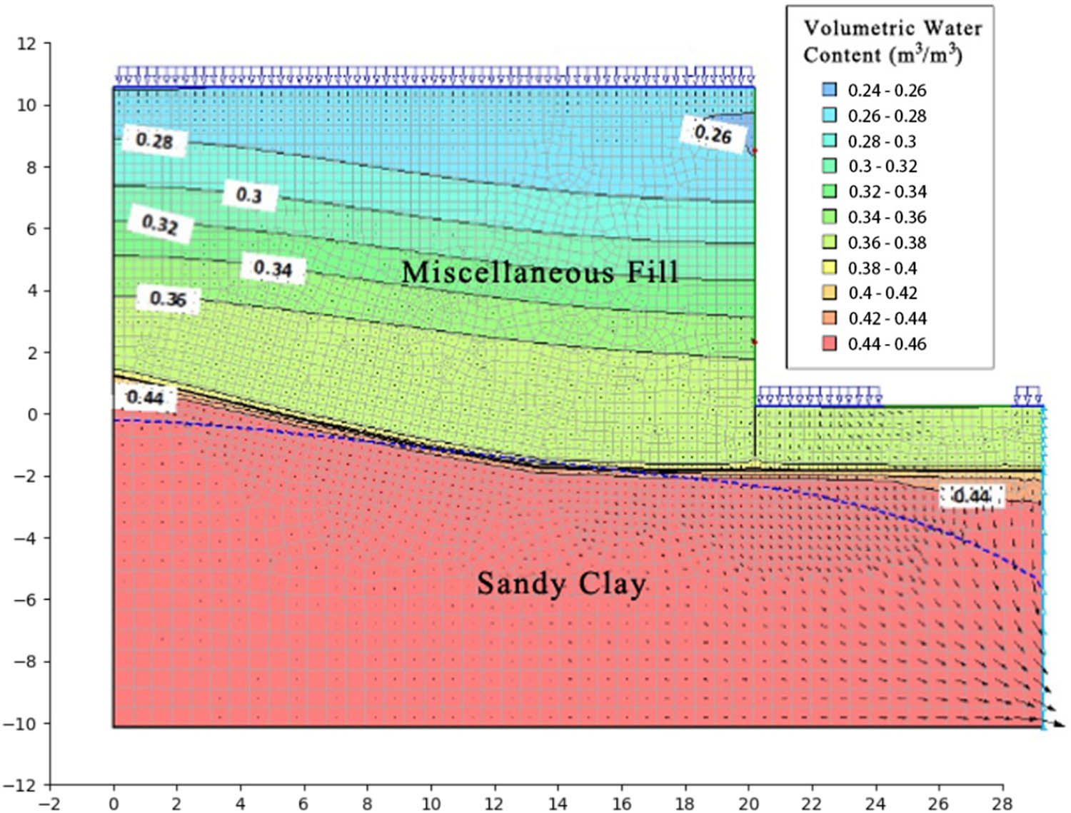
Volumetric water content of 1-day rainfall.

Volumetric water content of 10 days of rainfall.

Volumetric water content under heavy rain.
3.2 Analysis of slope stability decrease caused by rain
The change curve of the safety factor caused by the rain in the first 18 days is shown in Figure 10. It can be seen that under continuous rainfall conditions in July, the safety factor dropped from the initial 1.17 to 1.08, which was in an under-stable state. The slope safety factor changed in a slight decrease on the day of the rainfall. Then, after the increase in the second day’s rainfall, the safety factor had a relatively large reduction of about 0.02. The safety factor fluctuates due to the influence of rainfall in the following 12 days. For instance, the safety factor gained slightly due to the less rainfall on the 4th, 5th, 8th and 9th days. While the safety factor had a significant decrease with an increase of rainfall on the following day, e.g., the 6th and 10th days. With the impact of rainfall infiltration for dozens of days, the groundwater level of the slope increased, the severity increased and the sliding resistance decreased. The final safety factor quickly dropped to 1.08 at a rate of 0.02 per day on the 15th day, which was in an under-stable state. It can be observed that in the rainy season or under extreme rainstorm conditions, surface runoff and underground runoff are strong. The volumetric water content increases, and matrix adsorption force decreases or even approaches zero, resulting in high hydrodynamic pressure, sliding resistance reduction and slope safety reduction as well.

Sketch of changes in the safety factor.
3.3 Establishment of early warning model
Technical Code for Building Slope Engineering [19] is prepared with a view to implementing the national technical and economic policies in building slope engineering investigation, design, construction and quality control to achieve technical advancement, safety and reliability, economy and rationality, guaranteed quality and environmental protection. According to the code, the slope is seriously unstable and classified as a first-class slope, with a safety factor of F st = 1.35. It is found on the spot that the slope surface and retaining wall of the slope are seriously damaged, and the stability coefficient of the slope is already less than 1.35. To avoid economic losses caused by the instability of the slope, it is believed that monitoring instruments should be placed at the corresponding position of the slope and the trend of the slope should be observed in time. So the safety factor of 1.35 as the early warning upper bound loses the significance of the four-level warning. After the slope numerical simulation, the early warning and forecasting work is based on the calculated safety factor, and rainfall is used as the early warning indicator. See Table 2 for details.
Classification table of slope stability early warning and prediction
| Warning level | Red alert | Orange alert | Yellow alert | Blue alert |
|---|---|---|---|---|
| Stability factor F st | F st < 1.0 | 1.0 ≤ F st < 1.05 | 1.05 ≤ F st < 1.1 | F st ≥ 1.1 |
| Slope status | Unstable | Under stable | Basically stable | Stable |
In correspondence with the warning levels, the sketch of rainfall warning results, with the level of attention, warning, alerting and alarming, is drawn based on an 18-day safety factor change graph (see Figure 11). Figure 11 presents that while the rainfall during the rainy season reaches the attention level, the warning level for the cumulative rainfall of 70 mm corresponds to the safety factor of 1.1, the alerting level for the cumulative rainfall of 150 mm corresponds to the safety factor of 1.05 and the alarming level for the cumulative rainfall of over 160 mm corresponds to the safety factor of 1.0.

Sketch of rainfall warning results.
3.4 Warning model validation
The actual engineering geological environment is complex and under the combined influence of various inducing factors. The slope may be unstable and damaged. The stability of the slope can be characterized by the deformation tangent angle, which is mutually verified with the calculated stability coefficient to verify the accuracy of the early warning model [6].
The foundation has completed consolidation and settlement, and the numerical simulation results are difficult to completely match the actual project, with a gap between the results and the measured data [7]. The change rate and change trend of the two are consistent, so the displacement tangent angle is used as the early warning indicator. According to the improved deformation, tangential angle criterion presented by Xu et al. [20], 80, 85 and 89° are used as the warning boundary. As shown in Figure 12, the displacement tangent angle at the depth location of 9 m in the slope is used as another warning criterion for comparison and verification. The warning tangent angle limit lines (blue, yellow and red) are corresponding to the improved deformation tangential angle criterion (80, 85 and 89° related to the curve with a circle solid point).

Sketch of displacement tangent angle warning.
By comparing the two early warning models, it is found that the rainfall triggering conditions corresponding to the stability early warning model and the improved tangent angle early warning model are the same, showing the rationality of rainfall.
4 Conclusion
Early rainfall and rainfall types have a greater impact on slope stability. The actual rainfall can effectively restore the impact of antecedent rainfall. However, due to the lack of enough rainfall data, only one rainy season has been used. If rainfall data are sufficient, the rainy season rainfall distribution rule can be analyzed. The preliminary rainfall is more in line with the calculation requirements. Here, we can find:
To establish a rainfall early warning model, the numerical simulation method is combined with the drainage holes under rainfall conditions. Due to an early rainfall infiltration, the groundwater infiltrates to the position of the upper drainage hole, and the drainage hole and the groundwater have begun to work. The groundwater level on the left is higher than that on the right.
Rainfall has a significant and lagged impact on slope stability. The rainfall infiltration happens in rainfall, and the slope safety will decrease. Then, it may collapse.
The safety factor is a comprehensive characterization of the slope stability, which directly reflects the slope stability. The slope deformation can be used as a key factor to reflect the slope stability as well. The two indicators can be mutually verified to improve the accuracy of the rainfall thresholds for landslide early warning.
-
Funding information: This research was funded by the Basic Research Project of Department of Science and Technology of Sichuan Province (No. 2021YJ0335) and the General Project of Education Department in Sichuan Province (No. 16ZB0104).
-
Author contributions: Conceptualization, Huilong Wei; Data curation, Liyan Lao; Formal analysis, Huilong Wei and Zhijun Li; Funding acquisition and test, Xiaopeng Leng; Investigation, Weiyuan Wang and Baiqiang Zhong; Methodology, Ou Ou and Weiyuan Wang; Project administration, Jianjun Ruan; Software, Jianjun Ruan and Liyan Lao; Validation, Xuelei Du; Writing – original draft, Ou Ou.
-
Conflict of interest: Authors state no conflict of interest.
-
Data availability statement: All data included in this study are available upon request by contacting the corresponding author.
References
[1] Suzhen S, Wenhui G. Radial basis function neural network analysis method for stability of 2D random Field Slope. Rock Soil Mech. 2015;36(4):1205–10.Search in Google Scholar
[2] LTD. G-S I. Seepage modeling with SEEP. Calgary, Alberta, Canada: Geo-Slope International Ltd; 2010.Search in Google Scholar
[3] Liangtong Z, He L, Yunmin C, Fredlund DG. Analysis of influencing factors of rainfall-induced landslide prediction rainfall intensity duration curve in residual land area of southeast coast. Rock Soil Mech. 2012;33(3):872–880 + 886.Search in Google Scholar
[4] Hongming L. Study on the characteristics and stability of unsaturated seepage in landslides under rainfall infiltration conditions. Wuhan: China University of Geosciences (Wuhan); 2008.Search in Google Scholar
[5] Dong T, Dianqing L, Chuangbing Z, Guoguang F. Slope stability analysis considering early rainfall process. Rock Soil Mech. 2013;34(11):3239–48.Search in Google Scholar
[6] Guzzetti F, Peruccacci S, Rossi M, Stark CP. Rainfall thresholds for the initiation of landslides in central and southern Europe. Meteorol Atmos Phys. 2007;98:239–67. 10.1007/s00703-007-0262-7.Search in Google Scholar
[7] Segoni S, Rosi A, Rossi G, Catani F, Casagli N. Analysing the relationship between rainfalls and landslides to define a mosaic of triggering thresholds for regional-scale warning systems. Nat Hazards Earth Syst Sci. 2014;14:2637–48. 10.5194/nhess-14-2637-2014.Search in Google Scholar
[8] Guo XJ, Cui P, Li Y. Debris flow warning threshold based on antecedent rainfall: A case study in Jiangjia Ravine, Yunnan, China. J Mt Sci. 2013;10(2):305–14.10.1007/s11629-013-2521-zSearch in Google Scholar
[9] Aleotti P. A warning system for rainfall-induced shallow failures. Eng Geol. 2004;73(3–4):247–65.10.1016/j.enggeo.2004.01.007Search in Google Scholar
[10] Hong Y, Hiura H, Shino K, Sassa K, Suemine A, Fukuoka H, et al. The influence of intense rainfall on the activity of large-scale crystalline schist landslides in Shikoku Island, Jpn. Lands. 2005;2:97–105. 10.1007/s10346-004-0043-z.Search in Google Scholar
[11] Freder Lund DG, Laharzo H. Unsaturated soil mechanics. Chen Zhongying, et al. translated. Beijing: China Architecture Engineering Press; 1997.Search in Google Scholar
[12] Richardsr LA. Capillary conduction of liquids through porous medium. J Phys. 1931;1(5):318–33.10.1063/1.1745010Search in Google Scholar
[13] Fredlund DG, Morgenstern NR, Widger RA. The shear strength of unsaturated soils. Can Geotech J. 1978;15(3):313–21.10.1002/9781118280492.ch11Search in Google Scholar
[14] Vanapalli SK, Fredlund DG. Comparison of different procedures to predict unsaturated soil shear strength. Adv Unsatur Geotech. 2000;5:195–209.10.1061/40510(287)13Search in Google Scholar
[15] Escario V, Juca JF, Coppe MS. Strength and deformation of party saturated soils. In Congrès international de mécanique des sols et des travaux de fondations. 1989;12:43–6.Search in Google Scholar
[17] Shuyun G, Ou O, Yijun L, Chuanwei L, Jiafeng T, Hui W, et al. Research on slope disaster early warning model and its comprehensive application. J Guangxi Univ (Nat Sci Ed). 2019;44(4):1062–9.Search in Google Scholar
[16] John K. Geo-slope International Ltd. Stability modeling with slope/W2007 version. Calgary, Canada: Geo-slope International Ltd.; 2008.Search in Google Scholar
[18] Yabing J, Huang J, Jun L, Zhengchang D, Qiang Z, Ao Y. Application of rainfall-deformation coupling early warning model in Lijing mountain slope. J Guangxi Univ (Nat Sci Ed). 2019;44(3):834–44.Search in Google Scholar
[19] Urban C. Rural Construction Committee. Technical code for building slope engineering (GB 50330-2013). Beijing: China Architecture and Building Press; 2013.Search in Google Scholar
[20] Xu Q, Yuan Y, Zeng Y, Hack R. Some new pre-warning criteria for creep slope failure. Sci China Technol Sci. 2011;54:210–20.10.1007/s11431-011-4640-5Search in Google Scholar
© 2022 Huilong Wei et al., published by De Gruyter
This work is licensed under the Creative Commons Attribution 4.0 International License.
Articles in the same Issue
- Regular Articles
- Study on observation system of seismic forward prospecting in tunnel: A case on tailrace tunnel of Wudongde hydropower station
- The behaviour of stress variation in sandy soil
- Research on the current situation of rural tourism in southern Fujian in China after the COVID-19 epidemic
- Late Triassic–Early Jurassic paleogeomorphic characteristics and hydrocarbon potential of the Ordos Basin, China, a case of study of the Jiyuan area
- Application of X-ray fluorescence mapping in turbiditic sandstones, Huai Bo Khong Formation of Nam Pat Group, Thailand
- Fractal expression of soil particle-size distribution at the basin scale
- Study on the changes in vegetation structural coverage and its response mechanism to hydrology
- Spatial distribution analysis of seismic activity based on GMI, LMI, and LISA in China
- Rock mass structural surface trace extraction based on transfer learning
- Hydrochemical characteristics and D–O–Sr isotopes of groundwater and surface water in the northern Longzi county of southern Tibet (southwestern China)
- Insights into origins of the natural gas in the Lower Paleozoic of Ordos basin, China
- Research on comprehensive benefits and reasonable selection of marine resources development types
- Embedded deformation of the rubble-mound foundation of gravity-type quay walls and influence factors
- Activation of Ad Damm shear zone, western Saudi Arabian margin, and its relation to the Red Sea rift system
- A mathematical conjecture associates Martian TARs with sand ripples
- Study on spatio-temporal characteristics of earthquakes in southwest China based on z-value
- Sedimentary facies characterization of forced regression in the Pearl River Mouth basin
- High-precision remote sensing mapping of aeolian sand landforms based on deep learning algorithms
- Experimental study on reservoir characteristics and oil-bearing properties of Chang 7 lacustrine oil shale in Yan’an area, China
- Estimating the volume of the 1978 Rissa quick clay landslide in Central Norway using historical aerial imagery
- Spatial accessibility between commercial and ecological spaces: A case study in Beijing, China
- Curve number estimation using rainfall and runoff data from five catchments in Sudan
- Urban green service equity in Xiamen based on network analysis and concentration degree of resources
- Spatio-temporal analysis of East Asian seismic zones based on multifractal theory
- Delineation of structural lineaments of Southeast Nigeria using high resolution aeromagnetic data
- 3D marine controlled-source electromagnetic modeling using an edge-based finite element method with a block Krylov iterative solver
- A comprehensive evaluation method for topographic correction model of remote sensing image based on entropy weight method
- Quantitative discrimination of the influences of climate change and human activity on rocky desertification based on a novel feature space model
- Assessment of climatic conditions for tourism in Xinjiang, China
- Attractiveness index of national marine parks: A study on national marine parks in coastal areas of East China Sea
- Effect of brackish water irrigation on the movement of water and salt in salinized soil
- Mapping paddy rice and rice phenology with Sentinel-1 SAR time series using a unified dynamic programming framework
- Analyzing the characteristics of land use distribution in typical village transects at Chinese Loess Plateau based on topographical factors
- Management status and policy direction of submerged marine debris for improvement of port environment in Korea
- Influence of Three Gorges Dam on earthquakes based on GRACE gravity field
- Comparative study of estimating the Curie point depth and heat flow using potential magnetic data
- The spatial prediction and optimization of production-living-ecological space based on Markov–PLUS model: A case study of Yunnan Province
- Major, trace and platinum-group element geochemistry of harzburgites and chromitites from Fuchuan, China, and its geological significance
- Vertical distribution of STN and STP in watershed of loess hilly region
- Hyperspectral denoising based on the principal component low-rank tensor decomposition
- Evaluation of fractures using conventional and FMI logs, and 3D seismic interpretation in continental tight sandstone reservoir
- U–Pb zircon dating of the Paleoproterozoic khondalite series in the northeastern Helanshan region and its geological significance
- Quantitatively determine the dominant driving factors of the spatial-temporal changes of vegetation-impacts of global change and human activity
- Can cultural tourism resources become a development feature helping rural areas to revitalize the local economy under the epidemic? An exploration of the perspective of attractiveness, satisfaction, and willingness by the revisit of Hakka cultural tourism
- A 3D empirical model of standard compaction curve for Thailand shales: Porosity in function of burial depth and geological time
- Attribution identification of terrestrial ecosystem evolution in the Yellow River Basin
- An intelligent approach for reservoir quality evaluation in tight sandstone reservoir using gradient boosting decision tree algorithm
- Detection of sub-surface fractures based on filtering, modeling, and interpreting aeromagnetic data in the Deng Deng – Garga Sarali area, Eastern Cameroon
- Influence of heterogeneity on fluid property variations in carbonate reservoirs with multistage hydrocarbon accumulation: A case study of the Khasib formation, Cretaceous, AB oilfield, southern Iraq
- Designing teaching materials with disaster maps and evaluating its effectiveness for primary students
- Assessment of the bender element sensors to measure seismic wave velocity of soils in the physical model
- Appropriated protection time and region for Qinghai–Tibet Plateau grassland
- Identification of high-temperature targets in remote sensing based on correspondence analysis
- Influence of differential diagenesis on pore evolution of the sandy conglomerate reservoir in different structural units: A case study of the Upper Permian Wutonggou Formation in eastern Junggar Basin, NW China
- Planting in ecologically solidified soil and its use
- National and regional-scale landslide indicators and indexes: Applications in Italy
- Occurrence of yttrium in the Zhijin phosphorus deposit in Guizhou Province, China
- The response of Chudao’s beach to typhoon “Lekima” (No. 1909)
- Soil wind erosion resistance analysis for soft rock and sand compound soil: A case study for the Mu Us Sandy Land, China
- Investigation into the pore structures and CH4 adsorption capacities of clay minerals in coal reservoirs in the Yangquan Mining District, North China
- Overview of eco-environmental impact of Xiaolangdi Water Conservancy Hub on the Yellow River
- Response of extreme precipitation to climatic warming in the Weihe river basin, China and its mechanism
- Analysis of land use change on urban landscape patterns in Northwest China: A case study of Xi’an city
- Optimization of interpolation parameters based on statistical experiment
- Late Cretaceous adakitic intrusive rocks in the Laimailang area, Gangdese batholith: Implications for the Neo-Tethyan Ocean subduction
- Tectonic evolution of the Eocene–Oligocene Lushi Basin in the eastern Qinling belt, Central China: Insights from paleomagnetic constraints
- Geographic and cartographic inconsistency factors among different cropland classification datasets: A field validation case in Cambodia
- Distribution of large- and medium-scale loess landslides induced by the Haiyuan Earthquake in 1920 based on field investigation and interpretation of satellite images
- Numerical simulation of impact and entrainment behaviors of debris flow by using SPH–DEM–FEM coupling method
- Study on the evaluation method and application of logging irreducible water saturation in tight sandstone reservoirs
- Geochemical characteristics and genesis of natural gas in the Upper Triassic Xujiahe Formation in the Sichuan Basin
- Wehrlite xenoliths and petrogenetic implications, Hosséré Do Guessa volcano, Adamawa plateau, Cameroon
- Changes in landscape pattern and ecological service value as land use evolves in the Manas River Basin
- Spatial structure-preserving and conflict-avoiding methods for point settlement selection
- Fission characteristics of heavy metal intrusion into rocks based on hydrolysis
- Sequence stratigraphic filling model of the Cretaceous in the western Tabei Uplift, Tarim Basin, NW China
- Fractal analysis of structural characteristics and prospecting of the Luanchuan polymetallic mining district, China
- Spatial and temporal variations of vegetation coverage and their driving factors following gully control and land consolidation in Loess Plateau, China
- Assessing the tourist potential of cultural–historical spatial units of Serbia using comparative application of AHP and mathematical method
- Urban black and odorous water body mapping from Gaofen-2 images
- Geochronology and geochemistry of Early Cretaceous granitic plutons in northern Great Xing’an Range, NE China, and implications for geodynamic setting
- Spatial planning concept for flood prevention in the Kedurus River watershed
- Geophysical exploration and geological appraisal of the Siah Diq porphyry Cu–Au prospect: A recent discovery in the Chagai volcano magmatic arc, SW Pakistan
- Possibility of using the DInSAR method in the development of vertical crustal movements with Sentinel-1 data
- Using modified inverse distance weight and principal component analysis for spatial interpolation of foundation settlement based on geodetic observations
- Geochemical properties and heavy metal contents of carbonaceous rocks in the Pliocene siliciclastic rock sequence from southeastern Denizli-Turkey
- Study on water regime assessment and prediction of stream flow based on an improved RVA
- A new method to explore the abnormal space of urban hidden dangers under epidemic outbreak and its prevention and control: A case study of Jinan City
- Milankovitch cycles and the astronomical time scale of the Zhujiang Formation in the Baiyun Sag, Pearl River Mouth Basin, China
- Shear strength and meso-pore characteristic of saturated compacted loess
- Key point extraction method for spatial objects in high-resolution remote sensing images based on multi-hot cross-entropy loss
- Identifying driving factors of the runoff coefficient based on the geographic detector model in the upper reaches of Huaihe River Basin
- Study on rainfall early warning model for Xiangmi Lake slope based on unsaturated soil mechanics
- Extraction of mineralized indicator minerals using ensemble learning model optimized by SSA based on hyperspectral image
- Lithofacies discrimination using seismic anisotropic attributes from logging data in Muglad Basin, South Sudan
- Three-dimensional modeling of loose layers based on stratum development law
- Occurrence, sources, and potential risk of polycyclic aromatic hydrocarbons in southern Xinjiang, China
- Attribution analysis of different driving forces on vegetation and streamflow variation in the Jialing River Basin, China
- Slope characteristics of urban construction land and its correlation with ground slope in China
- Limitations of the Yang’s breaking wave force formula and its improvement under a wider range of breaker conditions
- The spatial-temporal pattern evolution and influencing factors of county-scale tourism efficiency in Xinjiang, China
- Evaluation and analysis of observed soil temperature data over Northwest China
- Agriculture and aquaculture land-use change prediction in five central coastal provinces of Vietnam using ANN, SVR, and SARIMA models
- Leaf color attributes of urban colored-leaf plants
- Application of statistical and machine learning techniques for landslide susceptibility mapping in the Himalayan road corridors
- Sediment provenance in the Northern South China Sea since the Late Miocene
- Drones applications for smart cities: Monitoring palm trees and street lights
- Double rupture event in the Tianshan Mountains: A case study of the 2021 Mw 5.3 Baicheng earthquake, NW China
- Review Article
- Mobile phone indoor scene features recognition localization method based on semantic constraint of building map location anchor
- Technical Note
- Experimental analysis on creep mechanics of unsaturated soil based on empirical model
- Rapid Communications
- A protocol for canopy cover monitoring on forest restoration projects using low-cost drones
- Landscape tree species recognition using RedEdge-MX: Suitability analysis of two different texture extraction forms under MLC and RF supervision
- Special Issue: Geoethics 2022 - Part I
- Geomorphological and hydrological heritage of Mt. Stara Planina in SE Serbia: From river protection initiative to potential geotouristic destination
- Geotourism and geoethics as support for rural development in the Knjaževac municipality, Serbia
- Modeling spa destination choice for leveraging hydrogeothermal potentials in Serbia