Distribution characteristics of typical geological relics in the Western Sichuan Plateau
-
Qizhong Wang
 ,
Yuan Yin
,
Yuan Yin

Abstract
The Western Sichuan Plateau (WSP), located in the eastern margin of the Qinghai–Tibet Plateau, is the most strongly deformed region of the continental crust in China. Frequent tectonic movements shape the unique topography and landform of the WSP and have also produced abundant geological heritage resources. Based on the existing geological heritage survey data in Sichuan Province, the nearest index analysis method of employing a regional spatial point model was used to reveal the distribution rules and the genetic mechanism of typical geological relics in the WSP for the first time. Results indicate that the formation and distribution of geological relics in the WSP are generally controlled by tectonic movement and supplemented by the comprehensive action of external forces such as flowing water. Their distribution shows a condensed spatial distribution pattern and extends along the strike of a fault zone and river strike strip. Finally, based on the characteristics of geological relics in the WSP, some suggestions on the protection and development of regional geological relics were put forward.
1 Introduction and regional geologic setting
The Western Sichuan Plateau (WSP) is located in the eastern section of the Hengduan Mountains, between the Qinghai–Tibet Plateau and the Sichuan Basin, and is a transitional zone between the first step and the second step. It is adjacent to the Laji Mountains, Buerhanbuda Mountains, Qilian Mountains, and the Qaidam Basin to the north; and is adjacent to the Yunnan–Guizhou Plateau in the south, the northern Tibetan Plateau in the west, and the Minshan Mountains and western Qinling Mountains in the east. The boundary in Sichuan is the line of Longmen Mountain, Dadu River, Xiaoxiangling, Jinping Mountain, and Bailin Mountain, with an area of about 3,00,000 square meters [1].
As shown in Figure 1, the overall terrain of the WSP gradually slopes from west to east, and the altitude dropped from 4,000 to 4,500 meters in the west to 3,000–3,500 meters in the east. Geomorphologic structure is based on the hill-shaped plateau surface or the segmented hill-top surface, with mountains on the top and valleys and basins below. The geomorphologic landscape in the area is divided into two levels, from northwest to southeast, forming the plateau geomorphology with large relief. There are several mountains in the NW–SE and N–S directions, such as Shaluli Mountain, Bayankala Mountain, Daxue Mountain, Minshan Mountain, and Longmen Mountain. In the south, the landscape is dominated by spectacular river valley landforms, with alternating mountains and rivers including the Jinsha River, Yalong River, and Minjiang River.
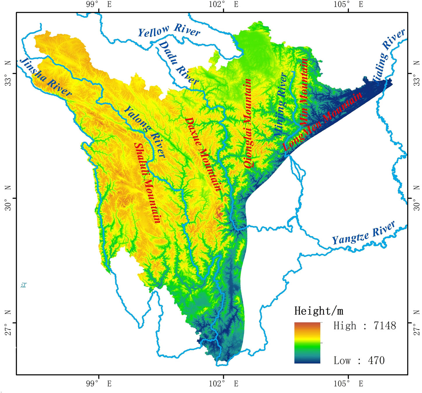
Landform elevation of Western Sichuan Plateau.
The WSP is strongly affected by the tectonic movement. The Tangula and Nyenchen Tanglha fold belt (37°N, 100°E) runs from the E–W to near N–S direction and extends into the region to form the Sanjiang fold belt, which widely affects the overthrust fault and the formation of deep faults. From west to east, the WSP can be divided into four tectonic zones: the Sanjiang fold belt, Songpan to Ganzi fold belt, Longmen Mountains Thrust–Nappe tectonic belt, and Longmen Mountain Foreland Basin.
The neotectonic activity in the WSP was highly active, and the Earth’s crust has been rising continuously since the Quaternary period, which has created unique high elevation peaks leading to snow-cover and glaciers in the WSP, and formed the magnificent and colorful layered landform and canyon landform. It has influenced the formation of the ancient Jinsha River, the Yalong River, and the Xianshui River in the Ganzi area, and has mapped out spectacular rivers, waterfalls, and other landscapes [2,3,4,5].
The WSP region has a complex and diverse climate. The northern part of the country has a high terrain and cold climate. It belongs to the semi-humid climate of the plateau sub-frigid zone and has developed alpine shrub meadows. The southern part of the valley is an alpine canyon landscape with vertical natural zone spectrum development. The valleys are mainly composed of a subtropical evergreen broad-leaved forest yellow soil zone. From the bottom to the top, the mountains feature a succession of vegetation and soil zones, including warm temperate evergreen deciduous broad-leaved forest yellow-brown soil zone, temperate coniferous and broad-leaved mixed forest brown soil zone, a sub-high cold temperate dark coniferous forest bleaching ash belts, alpine sub-frigid shrub alpine meadow soil belts, alpine shrub vegetation, frozen soil belts, and permanent ice and snow belts developed at high altitudes [1].
The WSP features complex tectonic environments and natural geographical conditions and is considered to be the smallest plateau in Sichuan Province. Due to the unique geological background and social development demands, the geology in this area has always attracted the attention of researchers and local governments. However, on the whole, the development of the area is still relatively backward, so how to combine the advantage of having rich geological relics with geological tourism has often been the focus of past research on landscape and geoscience. Presently, China is vigorously promoting the development of the tourism industry in the greater region, and deepening multidisciplinary integration through implementation of the policy designed for “planning the geographical space of the whole country in one blueprint”. Based on this policy focus, this study analyzed the typical regional geological relics from the perspective of science-based research. Moreover, the internal logic of spatial distribution of the typical regional geological relics was summarized, aiming to explore the protection and development of geological relics by means of regional coordination.
According to the classification criteria stipulated in the Specification for Geoheritage Investigation (DZ/T 0303-2017) issued by the Ministry of Natural Resources of the People’s Republic of China, geological relics are precious nonrenewable geological phenomena that were formed, developed, and preserved by various internal and external dynamic processes during the long geological history of the Earth. The geological relics are classified into three main types: basic geology, geological landscapes, and geological disasters; a feature with 13 categories and 46 subcategories in accordance with various factors, such as aesthetic value, causes, management requirements, and scientific value.
The geological heritage of the Sichuan Province is rich in resources and diverse in heritage type. Based on the data of the Distribution of Geoheritage in Sichuan Province from 2014 to 2020 issued by the Department of Natural Resources of Sichuan Province, the geological relics in the province can be divided into three main types, 11 categories, and 33 subcategories, totaling 389 geological relics by referring to the Specification for Geoheritage Investigation (DZ/T 0303-2017). The geological relics are categorized and proportioned as follows: for basic relics, 186 total, including 103 remnants of stratigraphic section (26.5%), 31 important fossil producing areas (8%), 22 important ore producing areas (5.7%), 16 tectonic sections (4.1%), and 14 rock sections (3.6%); for landscape relics, 174 total, including 65 geotechnical features (16.7%), 54 water features (13.9%), 30 geological features (7.7%), and 25 tectonic features (6.4%); and for disaster relics, 29 total, including 20 geological disasters (5.1%) and 9 earthquake relics (2.3%) (Table 1).
Sichuan Province geological relics statistics
| Main category | Category | Number of statistics | Proportion (%) |
|---|---|---|---|
| Geological heritage of basic geology (186 in total) | Stratum | 103 | 26.50 |
| Rock layer | 14 | 3.60 | |
| Geological structure | 16 | 4.10 | |
| Important origin of fossils | 31 | 8 | |
| Important origin of rock ore | 22 | 5.70 | |
| Geological heritage of geological landscape (174 in total) | Geotechnical landforms | 65 | 16.70 |
| Water landforms | 54 | 13.90 | |
| Glacier landforms | 30 | 7.70 | |
| Tectonic landforms | 25 | 6.40 | |
| Geological heritage of geological disasters (29 in total) | Earthquake ruins | 9 | 2.30 |
| Geological disaster ruins | 20 | 5.10 |
2 Definition and method descriptions
2.1 Distribution characteristics of typical geological relics in the WSP
The geological and tectonic environment of the WSP gives rise to its unique geographical and geomorphic characteristics, and has ultimately controlled the distribution of its typical geological relics.
By comparing the relics distribution in Sichuan Province with the relics distribution in the WSP, it can be concluded that: (i) seismic relics and geological disaster relics are mainly distributed on the dividing line between the WSP and the Sichuan Basin, which is controlled by the Longmenshan fault zone; however, there is no distribution of relics in other areas of the WSP; (ii) there are noticeable comparative advantages in the number and distribution of geological relics (e.g., stratigraphic, rock, and structural sections; important rock and ore producing areas, water geomorphology, and glacier geomorphology); however, the representation of the stratigraphic, rock, and structural sections is mainly considered in their selection criteria, and their distribution selection has strong subjectivity and randomness; and (iii) it can be seen that there is no comparative advantage in the distribution of tectonic and geomorphic relics in the WSP (10 in the WSP versus 15 in the non-WSP). However, further analysis shows that there are a large number of tectonic and geomorphic relics in the junction of the WSP and Sichuan Basin (mostly within the gorge). Therefore, according to the relationship between the formation of canyon landforms, river basins, and rivers, we believe that the large distribution of tectonic landforms remaining in this region is an extension of the distribution of geological remains in the WSP, which has a continuous significance. Therefore, this study takes hot spring geological relics, canyon geological relics, rock and ore geological relics, and glacier geological relics as typical geological relics of WSP (Table 2).
Contrasting statistical classification of geological relics in Sichuan Province and geological relics in the WSP
| Relic type | Total number of relics | WSP | Non-WSP |
|---|---|---|---|
| Section of stratum | 103 | 76 | 27 |
| Section of the rock layer | 14 | 14 | 0 |
| Section of geological structure | 16 | 14 | 2 |
| Important origin of fossils | 31 | 9 | 22 |
| Important origin of rock ore | 22 | 17 | 5 |
| Geotechnical landforms | 65 | 22 | 43 |
| Water landforms | 54 | 36 | 18 |
| Glacier landforms | 30 | 29 | 1 |
| Tectonic landforms | 25 | 10 | 15 |
| Earthquake ruins | 9 | All along the Longmenshan fault zone (along the | |
| Geological disaster ruins | 20 | boundary between the WSP and the Sichuan Basin) | |
2.2 Determination method of spatial distribution type of geological relics
Distribution laws of geological relics were studied by combining the comparative analysis of data and the nearest neighbor index (NNI) method. This research screened and analyzed the types of typical geological relics through data comparison and subjective and objective judgments and analyzed spatial distribution laws of the typical geological relics by utilizing the NNI method.
In order to explore the spatial distribution of geological relics in the WSP, combined with the point pattern characteristics of geological relics, this paper used the NNI [6], which makes a quantitative analysis of the spatial proximity of point-like objects (e.g., parks, tourist attractions, geological sites, etc.) in order to understand the spatial distribution of those objects (i.e., uniform, random, or cohesive distribution). We then combined the quantitative analysis with statistics of regional structure, geomorphology, and other factors to analyze the causes of geological heritage control of the spatial distribution of the typical geological relics. The specific method is described as follows:
“Nearest distance” refers to the distance between any point and its nearest point. Using the Euclidean distance formula, the nearest point and its distance of each event in the research area can be obtained. The distance is denoted as r(si), and the average value of the nearest neighbor in the study area is denoted by r1, and the formula is:
When the point distribution in the region is random, its theoretical nearest neighbor distance is denoted as re, which can be expressed as:
where re is the nearest theoretical distance, A is the area of the research area, and n is the research point. In point pattern space analysis, there are three distribution states, among which the closest neighbor distance of condensed distribution is the smallest, the closest neighbor distance of uniform distribution is the largest, and the random distribution is between the two. The index R of the nearest point is defined as the ratio of the actual nearest distance to the nearest distance of the random distribution. The formula is:
When R = 1, the point distribution is a random distribution. When R > 1, the point features tend to be uniformly distributed. When R < 1, the point features tend to be agglomerated.
According to the calculation of NNI, for hot spring geological relics there are 23 effective research sites in the WSP (two of which are orphans, therefore n = 21), while the research area was 3,00,000 km2 (A = 3,00,000 km2), and the average geological heritage of hot springs. For glacier geological relics, r1 = 55.16 km, the NNI was R = 0.92, n = 24, and the research area was 3,00,000 km2 (A = 3,00,000 km2), glaciers. For canyon geological relics, r1 = 49.18 km, the NNI was R = 0.879, n = 16, and the research area was 3,50,000 km2 (the study area includes the colored area of the river, A = 3,50,000 km2). For canyon-like geological relics r1 = 42.876 km, the NNI was R = 0.579. For rock ore-type geological relics, n = 17, the study area was 3,00,000 km2 (A = 3,00,000 km2), r1 = 37.1 km, and the NNI was R = 0.559. In summary, the nearest neighbor of the spatial distribution of the geological relics of the class and rock ore in the WSP Index R < 1, typically four in line with the spatial distribution geoheritage coagulated whole distribution pattern, along the main fault, banded convergence toward rivers (Table detailed calculations 3,4,5,6).
3 Description and classification of special geologic relics
3.1 Spatial distribution laws and cause analysis of hot spring geological relics
3.1.1 Spatial distribution laws of hot spring geological relics
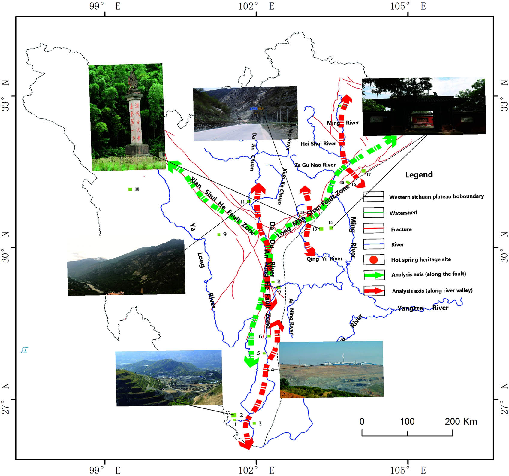
The geological relics of hot springs in the WSP are mainly distributed along the fault zone. The formation of hot springs is closely related to heat sources, aquifers, and hot water channels. Therefore, the deep fault zone of the WSP provides a constant source of heat for the hot springs (deep to the ground to facilitate the formation of heat sources, such as the Anning River fault and the Xianshuihe fault), and the intersection of faults (especially, the intersection of low-order sub-branched faults and high-order sub-main faults) provides a suitable method for the hot springs to emerge. From the perspective of spatial morphology, the hot springs of the WSP are mainly along the Anning River. The main fault zone, the Longmenshan fault zone, and the Xianshuihe fault zone developed [7].
Hot springs in the WSP developed along the river valley. The tectonic movements in the WSP are frequent, and the morphology of the land surface caused by the long-term large structural uplift is strongly undercut, so that the hot water layer can be widely exposed inside the deeper gullies. At the same time, the water level in the aquifer is lower and the static pressure in the upper layer is smaller. Both provide powerful conditions for the formation of the hot spring channel, which makes up the hot spring outcrop along the valley. Overall, the hot springs of the WSP are characterized by rivers and valleys along the Dadu River, the Yalong River, the Xiaojin River, and the Dajin River (Figure 2 and Table 3).
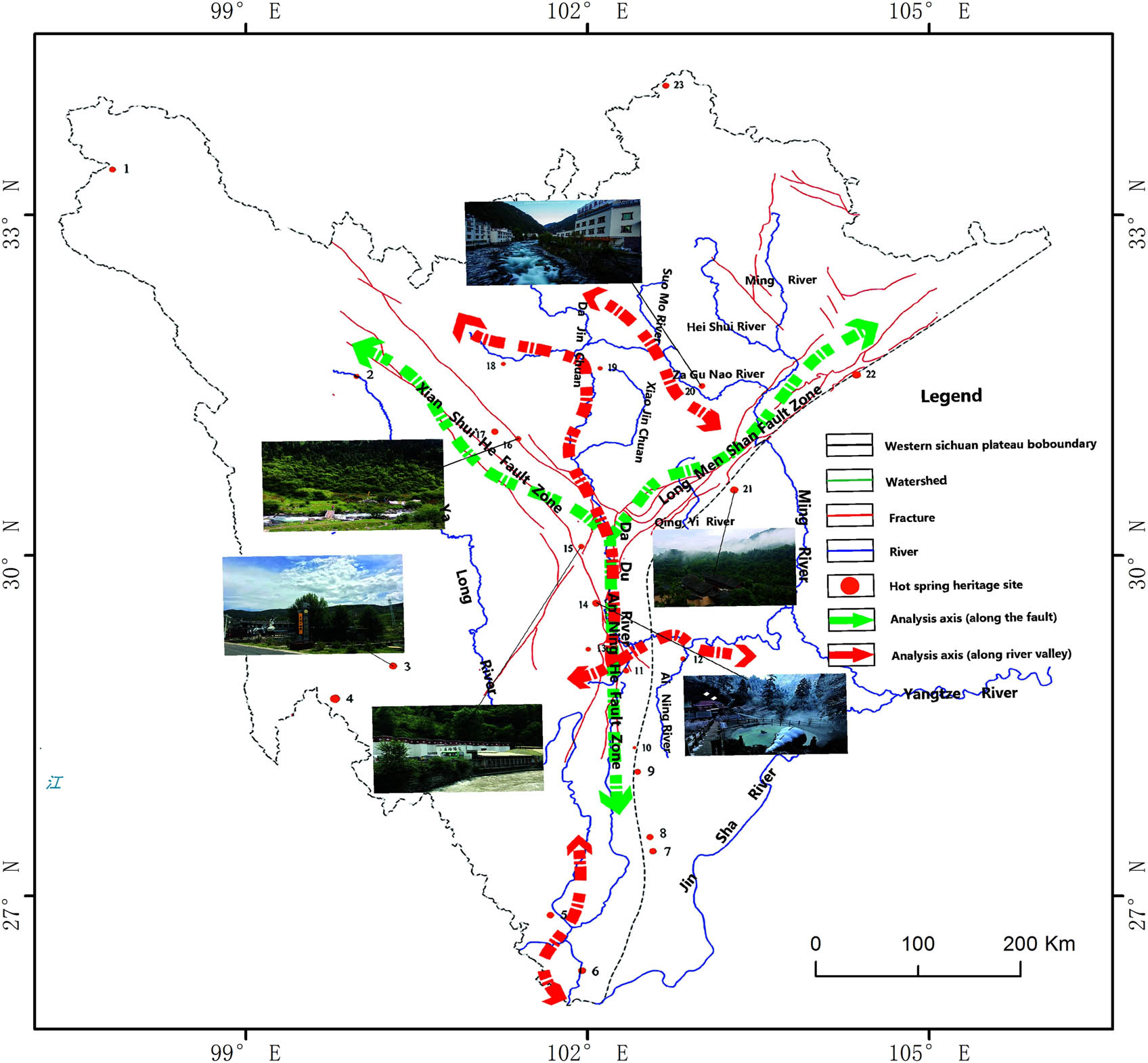
Analysis of the distribution pattern of hot spring geological relics.
Hot spring geological relic sites and NNI calculation statistics
| Serial number | Relic site | Nearest site | Nearest distance/km | Temperature at hot spring vents (°C) | Replenishing river |
|---|---|---|---|---|---|
| 1 | Xiayi Township Hot Spring, Shiqu County | Isolated | — | 40 | Zhaqu River |
| 2 | Chengnan Hot Spring, Ganzi County | 18 | 123 | 35 | Longchuan River |
| 3 | Rubu Hot Spring, Daocheng County | 4 | 56.4 | 70 | Camellia Creek |
| 4 | Ranwu Township Hot Spring, Xiangcheng County | 3 | 56.4 | 56 | Ranwu River |
| 5 | Hongge Hot Spring, Yanbian County | 6 | 58.09 | 57 | — |
| 6 | Hot Spring of Yuzha Hot Water Pool, Huili County | 5 | 58.09 | 60 | West Jinsha River |
| 7 | Puge Hot Spring, Puge County | 8 | 13.39 | 44 | Zemuhe River |
| 8 | Qiaowo Township Hot Spring Waterfall, Puge County | 7 | 13.39 | 40 | Dacao River |
| 9 | Hongma Hot Spring, Xide County | 10 | 23.14 | 52 | Reshui River |
| 10 | Lake Hot Spring, Xide County | 9 | 23.14 | 47 | Sunshui River |
| 11 | Gongyihao Hot Spring, Shimian County | 13 | 37.56 | 58 | Dadu River |
| 12 | Aidai Hot Spring, Ganluo County | 11 | 48.7 | 53 | Niri River |
| 13 | Hongba Hot Spring, Jiulong County | 11 | 37.56 | 61.2 | Moxigou |
| 14 | Hailuogou Hot Spring, Luding County | 13 | 47.41 | 89 | Hailuogou |
| 15 | Erqiao Hot Spring, Kangding County | 14 | 56.02 | 63 | Yarra River |
| 16 | Dangling Hot Spring, Danba County | 17 | 21.26 | 65 | Dangling River |
| 17 | Qimeike Hot Spring, Daofu County | 16 | 21.26 | 45 | / |
| 18 | Jiamudu Hot Spring, Rangtang County | 17 | 66.06 | 50 | Duke River |
| 19 | Davi Hot Spring, Davi Township, Malkang County | 18 | 80 | 48 | Jiaomuzu River |
| 20 | Guergou Shenfeng Hot Spring, Lixian County | 19 | 86.38 | 62 | Zagunao River |
| 21 | Huashuiwan Hot Spring, Dayi County | 20 | 103.9 | 68 | Huashuiwan River |
| 22 | Luofushan Hot Spring, Sangzao Town, Anxian County | 20 | 127.37 | 45 | Chaping River |
| 23 | Jiangzha Hot Spring, Zoige County | Isolated | — | 42 | Bailong River |
n = 21, r1 = 55.16 km, A = 3 × 10⁵ km2, R = 0.92.
3.1.2 Cause analysis of hot springs in the WSOP
Based on the field investigation, this study investigated possible causes of the formation of the following hot springs in the area by combining our findings with previous research: Rubu (Daocheng County), Huashuiwan, Hongge (Yanbian County), Hailuogou, Erqiao (Kangding County), and Hongba (Jiulong County).
Rubu Hot Spring, Daocheng County: the hot spring mainly outcrops from the strata of the Triassic Lanashan Formation, Indosinian adamellite, and the Quaternary alluvial system. Influenced by the deep Rubu fault, the basement rocks of the area are deeply cut and the rock mass is broken, which plays a decisive role in connecting with the deep heat source. Regarding hydrochemical composition, the Rubuchaka Hot Spring consists of a heavily carbonated-sodium fluoride type natural mineral water and has very low salinity. Anions present are mainly HCO³− and SO42−, while cations are dominated by Na+. Furthermore, it contains K+, Mg2+, Ca2+, and NH4+, and is medium-alkaline with a pH value of 7.7 and temperature of ∼70°C. The hot spring is mainly replenished by atmospheric precipitation and the melting of ice and snow from the mountainous areas. The deep heat source is likely accompanied by the heat released during the cooling of granite. The deep heat storage is formed by the heating action of the infiltration water. Under the action of high head pressure of aquifers, it flows upward along the fracture zone or fractures, and finally discharges under the artesian conditions, thus forming the Rubuchaka Hot Spring [26].
Huashuiwan Hot Spring: The hot spring is located in the transitional zone between the Sichuan Basin and the WSP and in anticlinal axis of the Wuzhong Mountain near the southwest plunging end. Coal reserves in the Upper Triassic Xujiahe Formation mainly outcrop in this area where they occur within the larger Longmenshan fault zone. The hot spring is mainly supplied by atmospheric precipitation through vertical infiltration along the joint fractures and lateral infiltration of the rivers. The hot spring water is generally of the Cl–SO4–Na-type, with salinity of 10.09/L and containing many trace elements, such as Li, Sr, B, H2S, F, and I. The temperature of the water is 68°C and the pH value is 7.1. The geothermal energy was formed by heating paleoseawater by the heat-temperature earth’s core during geological changes of sea and land in the ancient Sichuan Basin [27].
Hongge Hot Spring, Yanbian County: The hot spring is located in Hongge Town, Yanbian County, at the eastern edge of Hongge Basin in the transitional zone between the WSP and the Yunnan–Guizhou Plateau, adjacent to the Yayang River, which is a small tributary of the Jinsha River. The hot spring contains radium metaborate, radon, silicon, and hydrogen sulfide and ranges from 55°C to 56°C. The heat of the hot spring is mainly provided by the deep and large Xigeda fault. In addition, the interbedded layers of sand, mud, and shale at Xigeda fault serve as suitable thermal insulation layers, and ample precipitation, surface water, and karst water in this zone jointly interact, thus forming the hot spring [28].
Hailuogou Hot Spring: The hot spring features slightly mineralized brackish water in the type of HCO3–Na·Ca with multiple mineral compositions. The water is weakly alkaline and slightly mineralized with the pH value ranging from 7.8 to 7.9. The hot spring comprises multiple elements and compositions, such as F, H2S, H2SiO3, Sr, Fe, Ba, and Mn, and the temperature of water flowing out of the hot spring vent is 89–91.5°C. Hailuogou Hot Spring outcrops on a rhombic uplifting block in Minya Konka to the west of the large Moxi regional fault (southern section of the deeper and larger Xianshuihe fault), where there are intense neotectonic movements. Moreover, the faults and structural fractures are well developed and the faults mostly cut into the deep crust, which forms a suitable channel for the upward seepage of geothermal energy. In addition, there is abundant atmospheric precipitation, a wide distribution of glacial snow fields, and sufficient groundwater supply in this area, all of which provide superior geological and hydrogeological conditions for the formation of hot mineral water [29].
Erqiao Hot Springs, Kangding County: The hot springs are exposed on the west bank of the Yarra River, whose morphology is mainly controlled by the Yarragou fault. Rock masses around the vents are broken and fractures have developed. The vents of the hot spring are covered by Quaternary sediments. The hot spring water boils at about 32–56°C and flows out of Quaternary sediments on the west bank of Yarra River and has an odor of H2S. The hot spring in the study area is mainly supplied by atmospheric precipitation and snow melting. The huge heat generated by the deformation of the Xianshuihe fault is the main heat source for intense hydrothermal activities in the study area, which commonly constitutes the heat sources for hydrothermal activities in the study area together with energy caused by the decay of residual trace radioactive elements in granite and the local melting body [33].
Hongba Hot Spring, Jiulong County: the hot spring of the HCO3–Na type with high salinity is located in the northwest of Hongba Township and distributed along Moxigou. Repeatedly inherited and activated under the influence of multiple tectonic movements in the later period, the Zhenggou fault in the zone is characterized by multistage activities and squeezing first and then extension. Moreover, it deeply cuts the basement and is a heat conduction fault with inheritance, which plays an important role in connecting the deep heat source. In addition to the normal geothermal gradient of groundwater during the deep circulation in the earth’s crust, the heat of Hongba Hot Spring also comes from the heat carried by diorite during the upwelling and invasion, and the heat generated by the radioactive elements in the granite in mixed diorite. However, atmospheric precipitation and melting of ice and snow are the main water sources [30].
Based on the above analysis, the frequent tectonic function of the WSP reserves ample heat sources for the formation of hot springs (e.g., geological heat transfer in the fault zone, thermal cooling in the Yanshanian granite, new tectonic movements, mechanical heat generated by earthquakes, geothermal gradient warming, and chemical energy generated by radioactive element metamorphosis). In the case of certain precipitation supplements [8], hot springs are formed by geothermal heating, and under the promotion of structural force and geothermal circulation, through well-developed migration channels (fracture zones, tectonic movements, and earthquakes). The role of damage to the earth’s crust, and finally the formation of hot springs on the surface of the outcrop take place [9,10].
3.2 Distribution laws and cause analysis of geological relics in canyon geomorphology
3.2.1 Distribution laws of geological relics in canyon geomorphology
The overall layout of canyon-like geological relics is controlled by the action of water flow and tectonic action, showing the characteristics of agglomeration distribution at the intersection of river and fault. The tectonic movements in the WSP are frequent, and the tectonic action forms fault ruptures and a large number of joints, which provide a material basis for the formation of canyon geomorphology. At the same time, tectonic uplift and climate cycles will also change the erosion datum [11], accelerating the flow of water. The ecliptic effect provides an external force for the formation of typical canyons such as steep slopes and waterfalls. The geological relics of the canyons in this area have obvious distribution patterns at the junction of the Dadu River, Qingyi River, Minjiang River, and the Xianshuihe fault zone–Anninghe fault zone–Longmenshan fault zone (Figure 3 and Table 4).
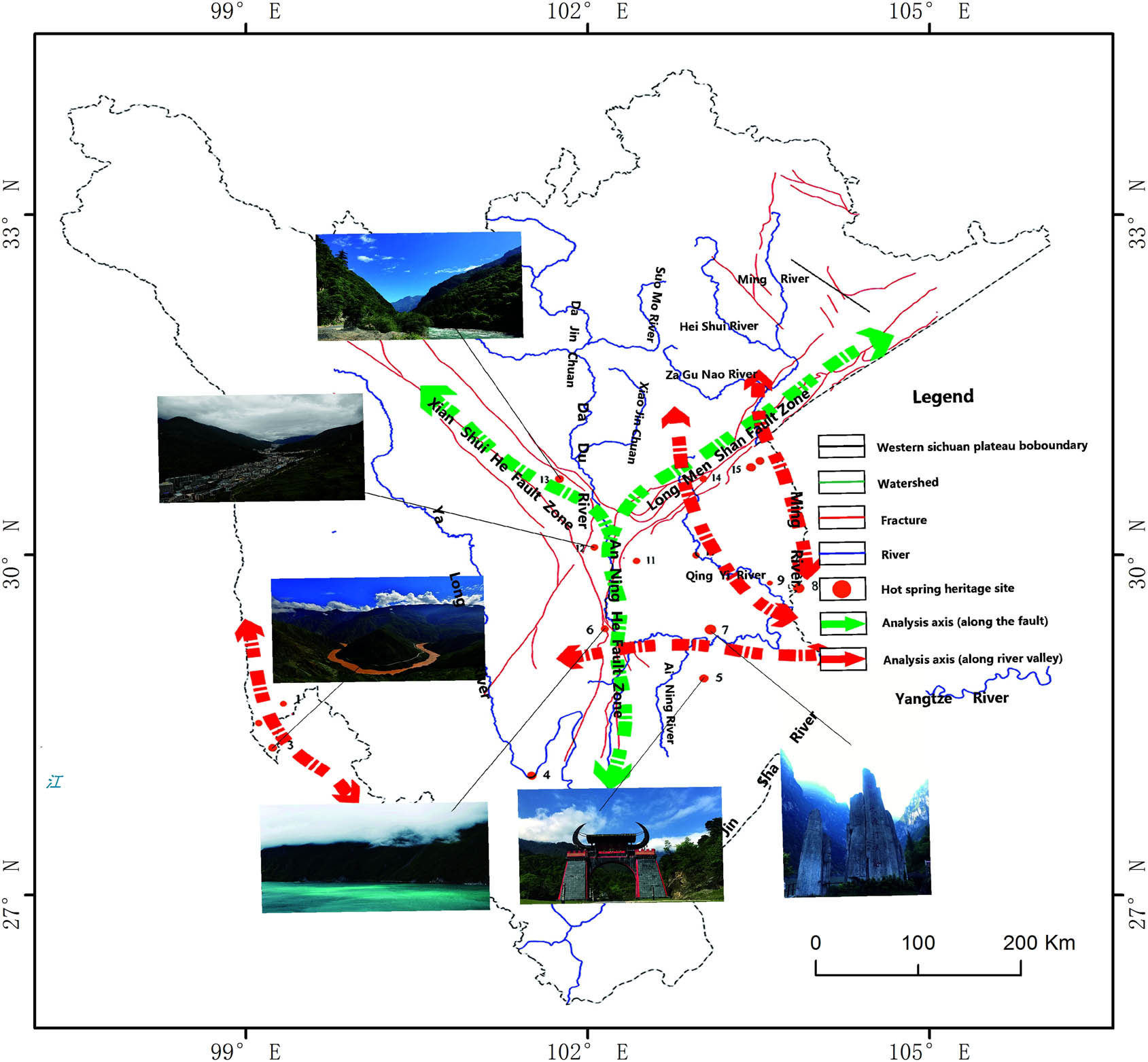
Analysis of the distribution of geological relics in the canyon type.
Canyon geological relic sites and NNI calculation statistics
| Serial number | Relic point name | Nearest site | Nearest distance/km |
|---|---|---|---|
| 1 | Mayi River Canyon, Derong County | 2 | 28.08 |
| 2 | Dingqu River Canyon, Derong County | 3 | 25.34 |
| 3 | Great bend of the Jinsha River, Derong County | 2 | 25.34 |
| 3 | Dajiang Bay Canyon, Yajiang County, Suining County | 6 | 156.9 |
| 5 | Heizhugou Canyon, Zhangbian County | 7 | 47.8 |
| 6 | Tianwan River Canyon, Shimian County | 11 | 69 |
| 7 | Dadu River Canyon, Jinkou River, Leshan City | 5 | 47.8 |
| 8 | Pingqiang Three Gorges in Qingshen County (Liaotouxia, Houyuxia, Pingyixia) | 9 | 22.77 |
| 9 | Nan’an River Canyon, Jiajiang County | 8 | 22.77 |
| 10 | Qingyijiang Two Gorge, Lushan County (Tongtouxia, Duogongxia | 11 | 47.9 |
| 11 | Erlang Mountain Canyon, Tianquan County | 12 | 37.65 |
| 12 | Kangding River Canyon, Kangding County | 11 | 37.65 |
| 13 | Donggu River Canyon in Danba County | 12 | 68.9 |
| 14 | Huangshuihe Canyon, Lushan County | 15 | 38.14 |
| 15 | Anzi River Canyon, Chongzhou City | 16 | 5 |
| 16 | Jiulonggou Canyon, Chongzhou City | 15 | 5 |
n = 16, r1 = 42.876 km, A = 3,50,000 km2, R = 0.579.
The geological relics of the canyons generally show the distribution pattern of accumulation in the middle and lower reaches of the Yalong River, Dadu River, Qingyi River, and Minjiang River. Combined with the 1:1 million geological maps in Sichuan Province, most of the associated areas of canyon landforms are sedimentary rocks such as sandstone, carbonate, conglomerate, and limestone. These rock types easily form valley landforms, such as rock sills, falls, waterfalls, and isolated peaks under the action of flow erosion, which also provide favorable geological conditions for the formation of valley landforms. At the same time, it can be inferred from the concentrated distribution of the canyon geological relics (the change in the erosion base level caused by the climate cycle and the change in the erosion base level lead to the intensification of the headstream erosion, which leads to the tendency of the river terrace and canyon landform to gather in the upper reaches of the river) that their formation is less affected by the climate cycle, and is mainly dominated by tectonics.
3.2.2 Cause analysis of canyon geomorphology in the WSP
In this study, the valley relic sites were all located in river valleys and simple valley geological relics were not involved; therefore, a cause analysis was performed using Jinkou River Canyon as a typical representative. Jinkou River Canyon is located in the lower reaches of Dadu River and in the transitional zone between the western edge of Sichuan Basin and Hengduan Mountains. The regional outcropping strata are composed of the Presinian system, Sinian system, Paleozoic Erathem, and Quaternary system, described as follows. The thickness of Presinian system is more than 6,000 m, interlaced with dolomite of 500–900 m thick; the Sinian dolomite is ∼1,000 m thick; the thickness of carbonate rocks in the Paleozoic Erathem is about 1,000 m; and the total thickness of carbonate rock in the area is 2,500–3,000 m. These carbonate rocks form narrow gorges with steep cliffs on both sides of the river and the valley depth is much larger than the valley width due to water flow and strong erosion. Furthermore, multigrade denudation surfaces and multistage terraces are formed in this area. The former is divided into six levels from top to bottom, i.e., Level 1 with the elevation of 3,200–3,300 m is represented by the Dawa Mountain; Level 2 is at the elevation of 2,800–2,900 m, represented by the adjacent Haiziping; Level 3 is at the elevation of 2,360–2,540 m and represented by Lanbaoping; Level 4 at the elevation of 1,750–2,050 m is represented by the Huangmu District; Level 5 at the elevation of 1,500–1,600 m is represented by Fangmaping; Level 6 is at 1,200–1,250 m elevation. Most of the canyons are formed by fluvial incision on the above denudation surfaces. For example, the Shunshui River canyon downstream of Chaping is formed by stream trenching on the Level 6 denudation surface, while there are 8-level terraces at the exit of Jinkou Grand Canyon. These illustrate that the area has experienced tectonic uplift many times. Based on the previous quantitative dating of this area, the average rising speed of the Earth’s crust in Jinkou Grand Canyon area since 1 Ma BP has been calculated to be 1.2 mm/a. The entire Jinkou River Canyon is the result of the joint action of tectonic uplift and fluvial incision, and is mainly controlled by lithology and tectonic movement.
Based on the research of Liu Yong et al., at present, the WSP is still in the process of uplift, with an average uplift rate of about 0.2–0.3 m/km. However, since the Pleistocene, the uplift rates of Zagunao River and Xianshui River have been 0.37 and 0.39 m/km, respectively. Therefore, we infer that the WSP has experienced frequent tectonism, and especially since the Quaternary period, it has experienced a great deal of tectonic uplift [12]. During this period, it has also experienced many glacial–interglacial cycles [13]. The superimposition of tectonic uplift and climate cycles resulted in hydration and metasomatism reactions, as well as a series of physical weathering when the river flowed through rock and soil mass including sandstone and carbonate rock that are easily eroded. Finally, the spectacular canyon geomorphology of the WSP was shaped after years of water erosion [14].
3.3 Distribution law and cause analysis of glacier geological relics
3.3.1 Distribution law of glacier geological relics
It is found that the glacial geological relics in Sichuan Province are mainly distributed along the Dadu River and the upper reaches of the Jinsha, Minjiang, and Yalong rivers. There are 24 samples of glacial relics in the distribution map of geological relics of the Sichuan Provincial Land Department. Among them, 23 are in the WSP and only one, located at the boundary between the WSP and the surrounding mountains, in the non-WSP. Considering the mapping errors comprehensively, the distribution of glacial geological relics in the WSP is very typical (Figure 4 and Table 5).
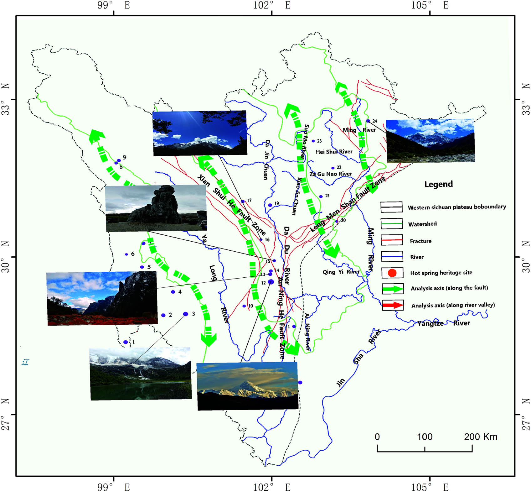
Analysis of the distribution of glacial geological relics.
Glacier geological relic sites and NNI calculation statistics
| Serial number | Relic site | Nearest site | Nearest distance/km |
|---|---|---|---|
| 1 | Ancient glacial remains of Balaqi Lake, Derong County | 2 | 88.8 |
| 2 | Ancient glacier relics of Balaqi Lake, Xiangxian County | 3 | 36.4 |
| 3 | Ancient glacier relics of Snow Mt. Aden, Daocheng County | 2 | 36.4 |
| 4 | Ancient glacier relics of Mt. Haizi, Daocheng County | 3 | 48.9 |
| 5 | Modern glacier and ancient glacier relics of Mt. Genie, Litang County | 6 | 37.8 |
| 6 | Modern glacier and ancient glacier relics of Dangjiezhenla, Batang County | 5 | 37.8 |
| 7 | Ancient glaciers of Mt. Haizi, Batang County | 6 | 40.2 |
| 8 | Modern glacier of Mt. Queer, Dege County | 9 | 3 |
| 9 | Xinluhai modern glacier, Dege County | 8 | 3 |
| 10 | Ruins of ancient glaciers of Mt. Wahui, Jiulong County | 12 | 68 |
| 11 | Ancient glaciers of Xiaoxiangling, Mianning County | 10 | 97 |
| 12 | Modern glacier in Hailuogou Valley, Luding County | 13 | 10.9 |
| 13 | Modern glacier in Yanzigou Valley, Luding County | 14 | 2 |
| 14 | Modern glaciers in Nanmenguan, Luding County | 13 | 2 |
| 15 | Ancient glaciers of Mt. Haizi, Kangding County | 14 | 18.9 |
| 16 | Ancient glacial remains of Snow Mt. Yarra, Kangding County | 15 | 48.6 |
| 17 | Remains of the ancient glaciers of Dangling County, Danba County | 19 | 49 |
| 18 | Modern glacier and ancient glacier ruins in Mt. Xiaoshitou, Aba County | 23 | 152 |
| 19 | Ancient glaciers of Mt. Meldo, Danba County | 17 | 49 |
| 20 | The remains of the ancient glaciers of Da Xuetang in Mt. Longmen, Dayi County | 21 | 56.5 |
| 21 | Modern glacier and ancient glacier ruins of Mt. Siguniang, Xiaojin County | 20 | 56.5 |
| 22 | Ancient glacial remains of Mengyu River, Li County | 21 | 63.8 |
| 23 | Ancient glaciers and ancient glacial sites, Heishui County | 22 | 68 |
| 24 | Modern glaciers and ancient glaciers of Xuebaoding, Songpan County | 23 | 106 |
n = 24, r1 = 49.18 km, A = 3,00,000 km2, R = 0.879.
The distribution of glacial geological relics decreases from west to east. There are seven glacial relics along the watershed of Jinsha River and Yalong River, seven along the watershed of Yalong River and Dadu River, three along the watershed of Dadu River and Minjiang River, and one along the watershed of Minjiang River and Jialing River, which is also consistent with the decreasing trend of elevation of the WSP from west to east.
The development of glaciers is closely related to topography, precipitation, and temperature. Since the Jurassic Yanshan Movement, the WSP has also experienced the Himalayan movement. The continuous uplift of the earth’s crust has created a series of extremely high mountains, such as the great snow mountain, Sharuli mountain, and Qionglai mountain. As a result, many mountainous areas are prominent above the glacier balance line [15] and have created a low-temperature condition for the development of glaciers (i.e., the peaks and ridges of these extreme mountains are often watersheds between the basins). These landscapes have also provided a wide area for ice and snow accumulation site leading to glacial development. In addition, being affected by the southeast monsoon, the high-humidity atmosphere from the ocean flows into the area from south to north, providing abundant material supply conditions for glacier development [16]. At the same time, since the Quaternary period, the WSP area has experienced many glacial cycles, which also provide temperature conditions for the formation of glaciers.
3.3.2 Cause analysis of glacier geological relics
Through field investigation, this study selected Hailuogou, Mt. Siguniang, and Xiaoxiangling glaciers for cause analysis by combining with theoretical research.
Hailuogou Glacier: Modern glacier in the Hailuogou Valley is located in the main peak of Minya Konka that belongs to the middle part of the Daxue Mountain. Under the compression of the Indosinian movement and Yanshan movement, a series of SN-trended structures were formed in the Daxue Mountain, which was uplifted largely again due to the very strong Neoid movement in the Quaternary period. In the middle part of the Daxue Mountain, the Minya Konka, with an altitude of 7,556 m, and the surrounding alpine areas with an altitude higher than 5,000 m were formed, which provided temperature conditions for the formation of the glacier. In terms of geographical conditions, the area is obliquely connected with the NE-trended Longmen Mountain in the north and adjacent to Qinghai–Tibet Plateau in the northwest. Moreover, it borders the SN-trended Hengduan Mountain system in the south and the SN-trended big and small Liangshan Mountains on the western margin of Sichuan Basin in the east. The NE-trended high mountain system in the north turns the northwest cold airflow to the south, which directly affects the area. The SN-trended Hengduan Mountain system and its deep valleys in the south form a corner with the SN-trended structural mountain system and deep valleys in Minya Konka. Under the effects of southeast monsoon, the air with high humidity at sea enters the area continuously along the mountains and valleys, which guarantees the water source for glacier formation, thus finally forming the current Hailuogou Glacier [31].
Glacier of Mt. Siguniang: Mt. Siguniang is located at the junction of Wenchuan County and Xiaojin County in Sichuan Province, which is in the middle-south section of Qionglai Mountain. Mt. Siguniang lies in the transitional zone between the eastern margin of Hengduan Mountain and Sichuan Basin, which belongs to a monsoon humid climate area. The southeast slope of the mountain is the windward slope of southeast warm and humid airflow, with abundant rainfall. Based on the classification of the existing four-level cirques and analysis of multistage glacial drift, it is shown that there have been many glaciations in this area since the Quaternary period. Climate change and the high altitude of Mt. Siguniang provide favorable low-temperature conditions for the development of the glacier, thus finally forming the Glacier of Mt. Siguniang [32].
Cause of Xiaoxiangling Glacier: Xiaoxiangling is the branch of the Snow Mt. on the eastern margin of Hengduan Mountain and belongs to the monsoon climate area with abundant rainfall. Since the Late Miocene to the Early Pliocene, the eastern margin of Qinghai–Tibet Plateau and Panzhihua–Xichang area have entered a rapid uplift and fluvial incision stage. It is estimated that the plateau was uplifted exceeding 2,000–2,500 m in this stage. Subsequently, scholars including Zhang Zonghu found that the third episode of the Daqingliangzi Movement in the Panzhihua–Xichang area also lifted Xiaoxiangling on a large scale, reaching the snowline, which allowed the formation of glaciers for the first time (large-scale high lateral moraine now visible in Xiaoxiangling). After that, Cheng Jianwu et al. studied the development of 4–5-level terraces along Anning River, and the 14C dating of Liu Weiming for Zhangla loess profile shows that Xiaoxiangling continues to experience uplift during this period. Wu Haibin et al. studied the Ganzi loess profile in the western Sichuan and found that the area experienced a significant cooling and dry–cold stage around 0.25 Ma BP, which offered the low-temperature conditions for the formation of Xiaoxiangling Glacier [34].
The WSP has experienced Himalayan movement since the Yanshanian movement in the Jurassic and the continuous uplift of the crust have created a series of extremely tall mountains, such as the Snow Mt., Shaluli Mountain, and Qionglai Mountain. These large mountains allow many peaks to protrude above the glacier equilibrium line [15]. This creates the low-temperature conditions for glacier development (the top and ridge of these extremely tall mountains are often the watersheds between basins), and also provides a wide area for ice and snow accumulation sites leading to glacier development. Since the Quaternary period, the WSP has experienced many glacial cycles, which also offer temperature conditions for the formation of the glaciers. In addition, under the influence of the southeast monsoon, the high-humidity air from the ocean constantly enters the area from south to north along the Sichuan Basin, structural mountain systems and their valleys, providing abundant material replenishment conditions for glacier development [16].
3.4 Distribution laws and cause analysis of rock and ore relics
3.4.1 Distribution laws of rock and ore relics
Based on the classification criteria stipulated in the Specification for Geoheritage Investigation (DZ/T 0303-2017) issued by the Ministry of Natural Resources of the People’s Republic of China, rock and ore relic sites are defined as mainly important rock and ore producing areas, including four parts, i.e., typical deposit outcrops, typical mineral and rock naming place, mining relics, and meteorite craters and bodies. The geological relics in this study are all mine and ore relic sites, except for four typical mine outcrops; the silver, lead, and zinc polymetallic mine (Gacun, Baiyu County); the Hongyan serpentine deposit (Pengzhou City); the Gyabjeka lithium–beryllium–niobium–tantalum deposit (Kangding County); and the Guobayan marble deposit (Baoxing County). Through comparative analysis and nearest neighbor analysis, it can be concluded that the rock and ore geological relics in this area have the following characteristics.
The remains of rock ore are distributed along the tectonic belt. Morphologically, the geological relics of rock ore in this area are mainly distributed along the Anninghe fault zone, the Xianshuihe fault zone, and the Longmenshan fault zone. Their genesis is related to the dynamic and material conditions for metallogenic mineral deposits by the deep and large fault belt cutting through the mantle [17] (Figure 5 and Table 6).
Analysis of the distribution of rock ore geological relics.
Rock ore geological relics and NNI calculation statistics
| Serial number | Relic site | Nearest site | Nearest distance/km | Major mineral deposits |
|---|---|---|---|---|
| 1 | Steel and titanium smelting mining relics in Nongnongping of Panzhihua, Renhe District | 2 | 5.2 | Ti |
| 2 | Vanadium ilmenite mining relics in the Lanjian Iron Mine of Panzhihua, Renhe District | 1 | 5.2 | FeTiO3 |
| 3 | Vanadium iron magnetite mining relics in Hongge Town, Yanbian County | 1 | 34.6 | V, FeV50, Fe3O4 |
| 4 | Smelter site of the Han dynasty, Xichang City | 5 | 34.2 | |
| 5 | Mining relics of vanadium ferrotitanium magnetite in Taihe District, Xichang City | 6 | 33.9 | TiO2, V2O5 |
| 6 | Luguhu “Luguhu Iron Mine” deposit and mining relics, Mianning County | 5 | 33.9 | Fe |
| 7 | Mining relics of asbestos in Shimian County | 8 | 7.9 | 3MgO·2SiO2·2H2O |
| 8 | Dashuigout mine deposit and mining relics in Xielao Township, Shimian County | 7 | 7.9 | |
| 9 | Gyabjeka lithium–beryllium–niobium–tantalum deposit, Kangding County | 11 | 87.8 | Li, Be, Nb, Ta |
| 10 | Silver, lead, and zinc polymetallic mine, Gacun, Baiyu County | 9 | 187 | Pb, Zn, Cu, Ag, Au |
| 11 | Muscovite mining relic, Danba County | 9 | 87.8 | KAl2(AlSi3O10)(OH)2 |
| 12 | Guobayan marble deposit, Baoxing County | 13 | 45.7 | CaCO₃, Mg CO₃, CaO |
| 13 | Huojing ancient natural gas mining relics, Qionglai City | 14 | 13 | CH4, H₂S |
| 14 | Shifangtang Qiongyao site, Qionglai City | 13 | 13 | Celadon glaze, celadon with brown mottles, and celadon with brown and green mottles and painted porcelain |
| 15 | Copper mining relics, Pengzhou City | 16 | 0 | Cu |
| 16 | Hongyan serpentine deposit, Pengzhou City | 15 | 0 | (Mg,Fe)3Si2O5(OH)4 |
| 17 | Longwangmiao–Wangjiaping phosphate deposit and mining relics, Mianzhu City | 16 | 33.6 | Ca3(PO4)2 |
n = 17, r1 = 37.1 km, A = 3,00,000 km2, R = 0.559.
The geological relics of rock ore in this area are distributed along the Anning River, Dadu River, Yalong River, Qingyi River, and Minjiang River. The mining of rock ore is closely related to human civilization. Most of the rock ore geological relics in this area are mining and metallurgical sites. Therefore, it is speculated that the reason for the distribution of relics along the river is mainly related to the outcrop of rocks and ores (flow erosion and tectonic effects are favorable for mineral deposits) and the large amount of industrial water needed for mining projects.
3.4.2 Cause analysis of rock and ore relics
Based on the study of Guobayan marble in Baoxing County and Gyabjeka lithium–beryllium–niobium–tantalum deposit in Kangding County, it can be obtained that rock mineralization is related to tectonic movement, volcanic movement, and sedimentation. The tectonic evolution of the WSP is complex. From the Early Paleozoic passive continental margin stage to the stage of Late Paleozoic–Triassic island sea activities which produced more edge structure, and through the Late Mesozoic back-arc orogenic stage to the Cenozoic intracontinental convergence–transform–strike–slip orogenic stage, a large number of tectonic movements have provided favorable conditions for producing rock metallogenic material [18,19,20].
4 Strategic planning model and the protection and development principles of geological heritage
4.1 Strategic planning model
The protection and development of geological relics is an important research topic at present. The previous single-point development mode has been isolated and has not performed well under the guidance of the current concept of tourism in the whole area. Therefore, this study took the internal logic of the distribution of regional geological relics as the tie, the protection of relics as the core, and the promotion of local social and economic development as the goal [21,22]. In this paper, the principle of “regional coordination, regional complementarity, and regional interaction” of geological relics protection and development is put forward with geological tourism as the carrier. This investigation aims to realize the seamless connection of relics protection, academic research, and tourism development through a period of cultivation, forming an organic circulation system of geological relics “preservation–development–protection”, achieving the organic unity of social benefits, economic benefits, and environmental benefits, and promoting the protection and sustainable development of geological relics resources, as shown in Figure 6.
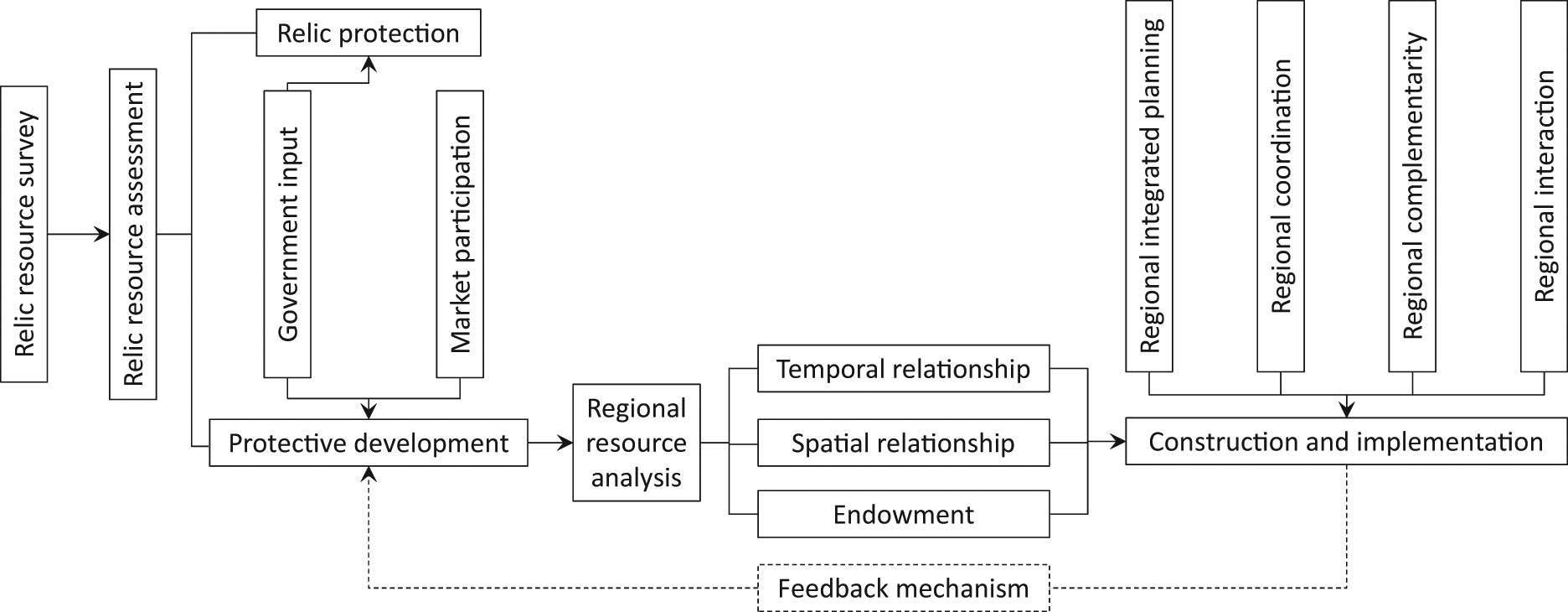
Strategic planning model.
4.2 Principle of overall regional planning
The goals of overall regional planning are to identify the regional geological resource base, clarify the distribution law of resources, find out the protection and development support constraints, identify the boundaries of protection and development conditions, plan from the perspective of regional resources, coordinate development and protection, and build a starting point. A regional geological resource protection development system combines line and surface systems. The overall planning goals are to evaluate the resources, the homogeneity, the difference, and the inheritance of the regional resource endowments, to compile the regional geological resources protection and development plan, and to uniformly arrange the regional geological tourism resources, while the overall construction is to share the regional infrastructure. As a basic principle, we will arrange regional public service facilities, regional municipal transportation facilities, and build a scientific, reasonable, and efficient geological tourism support system; the overall development and protection is to choose a reasonable protection development model according to local conditions, such as establishing (1) a Geology Park; (2) independent geological heritage protection areas; (3) nature reserves with geological contents; (4) geological relics protection in scenic spots; (5) geological relics protection in forest parks; (6) national or provincial key cultural relics protection units; and/or (7) mine parks, in order to build an organically linked geological heritage resource development and protection network [23].
4.3 Principle of regional complementarity
The complementarity of the region is based on the assessment of the scientific research value, aesthetic value, and tourism landscape value of geological resources; complementing regional spatial resources, complementing time resources, and complementing each other ecologically. Complementing regional spatial resources is based on the evaluation of regional geological heritage resources. Through the difference and inheritance characteristics between resource points, regional function distribution and regional resource integration are realized to achieve the purpose of “being beautiful is beautiful, and harmony is more beautiful.” Complementarity of time resources is achieved by combining the continuity of the different ages and different types of relics between the relic points, thus presenting the “Time Scroll” of the geological relics in the area. At the same time, based on the particularity of geological heritage protection, the principle of intermittent opening is adopted in its protection, and the linkage system of open management of regional heritage sites is overlapped. Through reasonable time arrangement, the purpose of intermittent “rotation” and periodic “rotation” of various geological sites can be achieved [24]. The ecological complementarity principle combined with the characteristics of vulnerability, sensitivity, and nonrenewability of the development and protection of geological heritage sites, the focus of the local industry in the cultivation of relic sites. Considering the ecological principle, we strive to achieve the goal of parallel development of conservation and ecological conservation.
4.4 Principle of regional coordination
Regional coordination emphasizes the “Head-to-tail” coordination between regions, development coordination, and market coordination. The purpose is to rely on the regional geological heritage resources, comprehensively analyze the human consumption needs [25], and expand the industrial chain of geological heritage markets, to improve the pedigree of geological tourism products with tourism as the main part, and geological science examination, popular science education, ecological tourism, tourism exploration, leisure and vacation as the supplementary parts.
4.5 Principle of regional interaction
The economic structure of the community where the relics are located and the area in which it is located are closely related to the protection and development of geological relics. Therefore, the principle of regional resonance and community linkage should be adhered to in the development of geological tourism. The principle of regional resonance and community linkage requires that the relics with certain tourism radiation be regarded as the focus of regional development, and combined with the national economic and social development plan to foster new growth points of regional economy through geological tourism and improve the community linkage mechanism to build geological tourism and the community interest linkage mechanism, build a community employment and employment platform, standardize the community tourism product promotion platform, and form a benign development structure [26] to protect development – the rise of the community – regional development.
5 Conclusions
Through this study, it is found that tectonic movement has a profound impact on the distribution of typical geological relics in the WSP, and is the main driving force for their formation, especially within the Ganzi–Litang fault, Xianshuihe fault, Anninghe fault, and Longmenshan fault zones. These deep fault zones played an important role in the genesis and distribution of various geological relics. At the same time, external forces such as flowing water had a profound impact on the formation of geological relics. The distribution of geological relics is generally represented by the evolution process of the Earth. Due to the comprehensive expression of the internal and external forces in the time series, most types of geological relics are distributed along the fault zone, and along the rivers their trend is a strip-like distribution. At the same time, in the process of protection and development of geological heritage in the WSP, the regional distribution characteristics of geological relics should be considered comprehensively, and the regional correlation, inheritance, and homogeneity of geological relics should be scientifically analyzed. In addition, the regional coordination, regional complementarity, regional coordination, and the principle of regional interaction establish a reasonable regional geological heritage protection system and promote the sustainable development of geological heritage protection and development.
In this article, despite the large amount of analysis and calculations, study limitations do exist, such as the number of samples studied, pioneering excavation of geological remains (limited exploration techniques and conditions), and subjectivity in data acquisition (statistics which may have neglected the smaller scales). Therefore, the results may not objectively explain the characteristics of the regional distribution and the genetic relationship of geological relics.
However, at present, this paper makes a pioneering study on the distribution characteristics and development strategies of geological heritage resources from a regional perspective. This study has suitable reference value for the construction of a regional geological relics network and the effective protection and development of regional geological relics.
Acknowledgments
This work is financially supported by Science & Technology Department of Sichuan Province (2019YFS0076) and Scientific Research Project of Natural Resources Department of Sichuan Province (KJ-2019-13), which are gratefully acknowledged.
References
[1] Gee ER. Overview of the geology and structure of the Salt Range with observations on related areas of northern Pakistan. Geological Society of America; Special Papers 232; 1989. p. 95–112.10.1130/SPE232-p95Suche in Google Scholar
[2] Zhao YN, Li CS, Lai XF. The geodetic structure and its evolution in Sichuan Province. China Regional Geol. 1984;8:1–21. Eighth Series.Suche in Google Scholar
[3] Zhao YN, Bin C. A brief introduction to the geological tectonic evolution in Sichuan Province. J Sichuan Geol. 2009;29:95–8. Whole Series.Suche in Google Scholar
[4] Zhao YN, Bin C. Main structural units and their characteristics in Sichuan Province. J Sichuan Geol. 2009;29:88–94. Whole Series.Suche in Google Scholar
[5] Chai ZX. On the formation of the Western Sichuan Plateau. Mt Res. 1983;1(4):22–30.Suche in Google Scholar
[6] Lei W. Study on the spatial distribution difference and sustainable development path of Guangxi Geological Park. Beijing: China University of Geosciences; 2018. p. 85–6.Suche in Google Scholar
[7] Wei Y, Shu GJ, Heng Z. Analysis of geological genesis of Hailuogou Hot Spring. China Min. 2015;24(4):83–7.Suche in Google Scholar
[8] Jian Z, Li WY, Tang XC. Analysis of geological genesis of Hailuogou Hot Spring. China Min Ind. 2015;24(4):85–6.Suche in Google Scholar
[9] Fu GH, Yin JC. Discussion on the distribution, genesis and tourism development of hot spring resources in Ganzi Prefecture of Sichuan Province. J Northwest Univ. 2009;39(1):142–8.Suche in Google Scholar
[10] Yang JH, Gao JC. Analysis and research on geothermal geological characteristics of Anning Hot Spring geothermal area. J Kunming Univ Sci Technol. 2008;33(5):1–6.Suche in Google Scholar
[11] Li CA, Lei S, Yuan SY, Dembele J. Geography-structural rhythm-climatic cycle coupling and discussion on the relationship between geological disasters in the three gorges. Geol Sci Technol Inf. 2012;31(5):65–8.Suche in Google Scholar
[12] Yong L, Cao SY, Zhou RJ. Quantitative constraints of the lower erosion rate of the lower cenozoic and its uplifting mechanism and formation time in the Eastern Margin of the Qinghai-Xizang Plateau. Acta Geologica Sin. 2005;79(1):29–36.Suche in Google Scholar
[13] Sun DQ, He PY. Progress in the study of quaternary glaciers in China in the past 20 years. Earth Sci. 1994;19(6):838–43.Suche in Google Scholar
[14] Li XQ, Shan W, Shun F, Wei YL. Analysis of the genesis and landscape value of the geological heritage of Baili Gorge in Xuanhan, Sichuan. J Guilin Univ Technol. 2010;30(1):56–61.Suche in Google Scholar
[15] Zhou SZ, Xu LB. Quaternary geomorphological development and environmental evolution of the Shaluli Mountains. Sci Lett. 2004;49(23):2480–4.Suche in Google Scholar
[16] Liu Q, Yong Z. Monitoring and research of marine glaciers in Gongga Mountain: history, current situation and prospects. J Mt Sci. 2017;35(5):717–26.Suche in Google Scholar
[17] Fu XF, Hou LZ, Yu RL, Wang DH, Ying LJ. Metallogenic regularity and metallogenic series in western Sichuan.Mineral Deposits. Geol evolution. 2006;25:15–18.Suche in Google Scholar
[18] Xie YL, Hou ZQ, Xu JH. Discovery and genetic significance of copper-zinc and copper-tin alloys in the Suining Dechang rare earth metallogenic belt, Sichuan Province. Sci China. 2005;35(6):572–7.Suche in Google Scholar
[19] Li JK, Wang DH, Fu XF. Study on ore-forming fluids of the Daba pegmatite-type muscovite deposit in Sichuan. J Geol. 2007;81(7):986–93.Suche in Google Scholar
[20] Xu HY, Chen XB, Zhao YZ. Analysis of metallogenic characteristics of the Daduhe gold deposit in Sichuan. Miner Geol. 2014;33:147–8.Suche in Google Scholar
[21] Dowling R. Geotourism’s global growth. Geoheritage. 2011;3:1–13.10.1007/s12371-010-0024-7Suche in Google Scholar
[22] Fang SM, Li JF, Zhao LS. Evaluation index system of geological relic resources. Earth Science-J China Univ Geosci. 2008;33(2):285–8.Suche in Google Scholar
[23] Han JF, Wu FD, Tian MD, Wei L. From geopark to sustainable development: heritage conservation and geotourism promotion in the Huangshan China. UNESCO Glob Geopark. 2018;10:79–91.Suche in Google Scholar
[24] Maslow AH. A theory of human motivation. Psychol Rev. 1943;50:370–96.10.1037/h0054346Suche in Google Scholar
[25] Wei G, Chung SS. Using tourism carrying capacity to strengthen management in Hong Kong. UNESCO Glob Geopark. 2019;11:193–205.Suche in Google Scholar
[26] Cao W-Z, Liu Z. Analysis on the geotectonic environment and the forming mechanism of the Rubuchaka Hot Spring in Daocheng. Pearl River. 2015;1:61–5.Suche in Google Scholar
[27] Chen M-X, He Y-W. Nature of geothermal water resources in HuaShuiWan, DaYi, ChengDu and the significance of its discovery. Acta Geol Sichuan. 1996;16(2):142–6.Suche in Google Scholar
[28] Liu M-F. A study on genesis of Hongge Hot Spring in Yanbian, Sichuan Province. Coal Geol China. 2008;20(3):45–8.Suche in Google Scholar
[29] Yuan W, Ran G-J, Zhang H. Genetic analysis of Hailuogou hotspring. China Min Mag. 2015;24(4):83–87.Suche in Google Scholar
[30] Wang M-F, Li X, Jiao X-W. Hydrogeochemical characteristics and origin of mofanggou Hot Spring in Jiulong County. Ground Water. 2014;36(1):29–31.Suche in Google Scholar
[31] Xu Z-N. Preliminary analysis of origin of Hai Luo ditch glacier. J Southwest Pet Inst. 1989;11(4):16–22.Suche in Google Scholar
[32] Liu S-Z, Chai Z-X, Chen J-L. Preliminary investigation on Glaciation Mountainous Region if Wenchuan in Sichuan Province. J Glaciol Geocryol. 1986;8(1):73–81.Suche in Google Scholar
[33] Huang X. Study on the Chemical Characteristics and the Genesis of Hot Springs in the Middle Section of Xianshuihe Fault Zone. Sichuan: Chengdu University Of Technology; 2019.Suche in Google Scholar
[34] Cui P. The Preliminary Study on the Quaternary Glacial Landforms and Glacial Age in the East Slope of Xiao Xiangling Mountain, Sichuan. Liaoning: Liaoning Normal University; 2017.Suche in Google Scholar
© 2020 Qizhong Wang et al., published by De Gruyter
This work is licensed under the Creative Commons Attribution 4.0 International License.
Artikel in diesem Heft
- Regular Articles
- The simulation approach to the interpretation of archival aerial photographs
- The application of137Cs and210Pbexmethods in soil erosion research of Titel loess plateau, Vojvodina, Northern Serbia
- Provenance and tectonic significance of the Zhongwunongshan Group from the Zhongwunongshan Structural Belt in China: insights from zircon geochronology
- Analysis, Assessment and Early Warning of Mudflow Disasters along the Shigatse Section of the China–Nepal Highway
- Sedimentary succession and recognition marks of lacustrine gravel beach-bars, a case study from the Qinghai Lake, China
- Predicting small water courses’ physico-chemical status from watershed characteristics with two multivariate statistical methods
- An Overview of the Carbonatites from the Indian Subcontinent
- A new statistical approach to the geochemical systematics of Italian alkaline igneous rocks
- The significance of karst areas in European national parks and geoparks
- Geochronology, trace elements and Hf isotopic geochemistry of zircons from Swat orthogneisses, Northern Pakistan
- Regional-scale drought monitor using synthesized index based on remote sensing in northeast China
- Application of combined electrical resistivity tomography and seismic reflection method to explore hidden active faults in Pingwu, Sichuan, China
- Impact of interpolation techniques on the accuracy of large-scale digital elevation model
- Natural and human-induced factors controlling the phreatic groundwater geochemistry of the Longgang River basin, South China
- Land use/land cover assessment as related to soil and irrigation water salinity over an oasis in arid environment
- Effect of tillage, slope, and rainfall on soil surface microtopography quantified by geostatistical and fractal indices during sheet erosion
- Validation of the number of tie vectors in post-processing using the method of frequency in a centric cube
- An integrated petrophysical-based wedge modeling and thin bed AVO analysis for improved reservoir characterization of Zhujiang Formation, Huizhou sub-basin, China: A case study
- A grain size auto-classification of Baikouquan Formation, Mahu Depression, Junggar Basin, China
- Dynamics of mid-channel bars in the Middle Vistula River in response to ferry crossing abutment construction
- Estimation of permeability and saturation based on imaginary component of complex resistivity spectra: A laboratory study
- Distribution characteristics of typical geological relics in the Western Sichuan Plateau
- Inconsistency distribution patterns of different remote sensing land-cover data from the perspective of ecological zoning
- A new methodological approach (QEMSCAN®) in the mineralogical study of Polish loess: Guidelines for further research
- Displacement and deformation study of engineering structures with the use of modern laser technologies
- Virtual resolution enhancement: A new enhancement tool for seismic data
- Aeromagnetic mapping of fault architecture along Lagos–Ore axis, southwestern Nigeria
- Deformation and failure mechanism of full seam chamber with extra-large section and its control technology
- Plastic failure zone characteristics and stability control technology of roadway in the fault area under non-uniformly high geostress: A case study from Yuandian Coal Mine in Northern Anhui Province, China
- Comparison of swarm intelligence algorithms for optimized band selection of hyperspectral remote sensing image
- Soil carbon stock and nutrient characteristics of Senna siamea grove in the semi-deciduous forest zone of Ghana
- Carbonatites from the Southern Brazilian platform: I
- Seismicity, focal mechanism, and stress tensor analysis of the Simav region, western Turkey
- Application of simulated annealing algorithm for 3D coordinate transformation problem solution
- Application of the terrestrial laser scanner in the monitoring of earth structures
- The Cretaceous igneous rocks in southeastern Guangxi and their implication for tectonic environment in southwestern South China Block
- Pore-scale gas–water flow in rock: Visualization experiment and simulation
- Assessment of surface parameters of VDW foundation piles using geodetic measurement techniques
- Spatial distribution and risk assessment of toxic metals in agricultural soils from endemic nasopharyngeal carcinoma region in South China
- An ABC-optimized fuzzy ELECTRE approach for assessing petroleum potential at the petroleum system level
- Microscopic mechanism of sandstone hydration in Yungang Grottoes, China
- Importance of traditional landscapes in Slovenia for conservation of endangered butterfly
- Landscape pattern and economic factors’ effect on prediction accuracy of cellular automata-Markov chain model on county scale
- The influence of river training on the location of erosion and accumulation zones (Kłodzko County, South West Poland)
- Multi-temporal survey of diaphragm wall with terrestrial laser scanning method
- Functionality and reliability of horizontal control net (Poland)
- Strata behavior and control strategy of backfilling collaborate with caving fully-mechanized mining
- The use of classical methods and neural networks in deformation studies of hydrotechnical objects
- Ice-crevasse sedimentation in the eastern part of the Głubczyce Plateau (S Poland) during the final stage of the Drenthian Glaciation
- Structure of end moraines and dynamics of the recession phase of the Warta Stadial ice sheet, Kłodawa Upland, Central Poland
- Mineralogy, mineral chemistry and thermobarometry of post-mineralization dykes of the Sungun Cu–Mo porphyry deposit (Northwest Iran)
- Main problems of the research on the Palaeolithic of Halych-Dnister region (Ukraine)
- Application of isometric transformation and robust estimation to compare the measurement results of steel pipe spools
- Hybrid machine learning hydrological model for flood forecast purpose
- Rainfall thresholds of shallow landslides in Wuyuan County of Jiangxi Province, China
- Dynamic simulation for the process of mining subsidence based on cellular automata model
- Developing large-scale international ecological networks based on least-cost path analysis – a case study of Altai mountains
- Seismic characteristics of polygonal fault systems in the Great South Basin, New Zealand
- New approach of clustering of late Pleni-Weichselian loess deposits (L1LL1) in Poland
- Implementation of virtual reference points in registering scanning images of tall structures
- Constraints of nonseismic geophysical data on the deep geological structure of the Benxi iron-ore district, Liaoning, China
- Mechanical analysis of basic roof fracture mechanism and feature in coal mining with partial gangue backfilling
- The violent ground motion before the Jiuzhaigou earthquake Ms7.0
- Landslide site delineation from geometric signatures derived with the Hilbert–Huang transform for cases in Southern Taiwan
- Hydrological process simulation in Manas River Basin using CMADS
- LA-ICP-MS U–Pb ages of detrital zircons from Middle Jurassic sedimentary rocks in southwestern Fujian: Sedimentary provenance and its geological significance
- Analysis of pore throat characteristics of tight sandstone reservoirs
- Effects of igneous intrusions on source rock in the early diagenetic stage: A case study on Beipiao Formation in Jinyang Basin, Northeast China
- Applying floodplain geomorphology to flood management (The Lower Vistula River upstream from Plock, Poland)
- Effect of photogrammetric RPAS flight parameters on plani-altimetric accuracy of DTM
- Morphodynamic conditions of heavy metal concentration in deposits of the Vistula River valley near Kępa Gostecka (central Poland)
- Accuracy and functional assessment of an original low-cost fibre-based inclinometer designed for structural monitoring
- The impacts of diagenetic facies on reservoir quality in tight sandstones
- Application of electrical resistivity imaging to detection of hidden geological structures in a single roadway
- Comparison between electrical resistivity tomography and tunnel seismic prediction 303 methods for detecting the water zone ahead of the tunnel face: A case study
- The genesis model of carbonate cementation in the tight oil reservoir: A case of Chang 6 oil layers of the Upper Triassic Yanchang Formation in the western Jiyuan area, Ordos Basin, China
- Disintegration characteristics in granite residual soil and their relationship with the collapsing gully in South China
- Analysis of surface deformation and driving forces in Lanzhou
- Geochemical characteristics of produced water from coalbed methane wells and its influence on productivity in Laochang Coalfield, China
- A combination of genetic inversion and seismic frequency attributes to delineate reservoir targets in offshore northern Orange Basin, South Africa
- Explore the application of high-resolution nighttime light remote sensing images in nighttime marine ship detection: A case study of LJ1-01 data
- DTM-based analysis of the spatial distribution of topolineaments
- Spatiotemporal variation and climatic response of water level of major lakes in China, Mongolia, and Russia
- The Cretaceous stratigraphy, Songliao Basin, Northeast China: Constrains from drillings and geophysics
- Canal of St. Bartholomew in Seča/Sezza: Social construction of the seascape
- A modelling resin material and its application in rock-failure study: Samples with two 3D internal fracture surfaces
- Utilization of marble piece wastes as base materials
- Slope stability evaluation using backpropagation neural networks and multivariate adaptive regression splines
- Rigidity of “Warsaw clay” from the Poznań Formation determined by in situ tests
- Numerical simulation for the effects of waves and grain size on deltaic processes and morphologies
- Impact of tourism activities on water pollution in the West Lake Basin (Hangzhou, China)
- Fracture characteristics from outcrops and its meaning to gas accumulation in the Jiyuan Basin, Henan Province, China
- Impact evaluation and driving type identification of human factors on rural human settlement environment: Taking Gansu Province, China as an example
- Identification of the spatial distributions, pollution levels, sources, and health risk of heavy metals in surface dusts from Korla, NW China
- Petrography and geochemistry of clastic sedimentary rocks as evidence for the provenance of the Jurassic stratum in the Daqingshan area
- Super-resolution reconstruction of a digital elevation model based on a deep residual network
- Seismic prediction of lithofacies heterogeneity in paleogene hetaoyuan shale play, Biyang depression, China
- Cultural landscape of the Gorica Hills in the nineteenth century: Franciscean land cadastre reports as the source for clarification of the classification of cultivable land types
- Analysis and prediction of LUCC change in Huang-Huai-Hai river basin
- Hydrochemical differences between river water and groundwater in Suzhou, Northern Anhui Province, China
- The relationship between heat flow and seismicity in global tectonically active zones
- Modeling of Landslide susceptibility in a part of Abay Basin, northwestern Ethiopia
- M-GAM method in function of tourism potential assessment: Case study of the Sokobanja basin in eastern Serbia
- Dehydration and stabilization of unconsolidated laminated lake sediments using gypsum for the preparation of thin sections
- Agriculture and land use in the North of Russia: Case study of Karelia and Yakutia
- Textural characteristics, mode of transportation and depositional environment of the Cretaceous sandstone in the Bredasdorp Basin, off the south coast of South Africa: Evidence from grain size analysis
- One-dimensional constrained inversion study of TEM and application in coal goafs’ detection
- The spatial distribution of retail outlets in Urumqi: The application of points of interest
- Aptian–Albian deposits of the Ait Ourir basin (High Atlas, Morocco): New additional data on their paleoenvironment, sedimentology, and palaeogeography
- Traditional agricultural landscapes in Uskopaljska valley (Bosnia and Herzegovina)
- A detection method for reservoir waterbodies vector data based on EGADS
- Modelling and mapping of the COVID-19 trajectory and pandemic paths at global scale: A geographer’s perspective
- Effect of organic maturity on shale gas genesis and pores development: A case study on marine shale in the upper Yangtze region, South China
- Gravel roundness quantitative analysis for sedimentary microfacies of fan delta deposition, Baikouquan Formation, Mahu Depression, Northwestern China
- Features of terraces and the incision rate along the lower reaches of the Yarlung Zangbo River east of Namche Barwa: Constraints on tectonic uplift
- Application of laser scanning technology for structure gauge measurement
- Calibration of the depth invariant algorithm to monitor the tidal action of Rabigh City at the Red Sea Coast, Saudi Arabia
- Evolution of the Bystrzyca River valley during Middle Pleistocene Interglacial (Sudetic Foreland, south-western Poland)
- A 3D numerical analysis of the compaction effects on the behavior of panel-type MSE walls
- Landscape dynamics at borderlands: analysing land use changes from Southern Slovenia
- Effects of oil viscosity on waterflooding: A case study of high water-cut sandstone oilfield in Kazakhstan
- Special Issue: Alkaline-Carbonatitic magmatism
- Carbonatites from the southern Brazilian Platform: A review. II: Isotopic evidences
- Review Article
- Technology and innovation: Changing concept of rural tourism – A systematic review