The Cretaceous igneous rocks in southeastern Guangxi and their implication for tectonic environment in southwestern South China Block
-
Yang Liu
 ,
Menglin Qiang
,
Menglin Qiang

Abstract
Southeastern Guangxi is located in the southwestern South China Block and to the northwest of the South China Sea (SCS), with abundant records of the Cretaceous magmatism. A detailed study of igneous rocks will contribute to a better understanding of the late Mesozoic tectonic environment. Zircon U–Pb dating yields ages of 93.37 ± 0.43 Ma for Yulin andesites and 107.6 ± 1.2 Ma for Luchuan granites. Yulin andesites are hornblende andesites, of which w(MgO) is between 7.72% and 8.42%, and Mg# is between 66.7 and 68.0, belonging to high magnesian andesites (HMAs) from peridotite sources. Luchuan granites are medium- to fine-grained monzogranites. Monzogranites and clastoporphyritic lava are high-K calc-alkaline series and metaluminum to weakly peraluminous series, which belong to the I-type granites. Those are enriched in Rb, Th, K and LREEs and depleted in Nb, Ta, P and Eu, showing the geochemical characteristics related to subduction. Unlike the contemporary “bimodal igneous rock assemblages” in Zhejiang and Fujian, the intermediate-acid magmatites in the southeastern Guangxi imply the compressive tectonic environment. The assemblage of HMAs and adakitic rocks indicates that the southwestern South China Block was under the Neo-Tethyan subduction during Cretaceous, and slab melting contributed to the magma in this area.
1 Introduction
South China Block lies between the Tethyan tectonic belt and Pacific tectonic belt [1]. It is a crucial period for magmatic rocks and mineralization in southwestern South China Block in Cretaceous, especially in the range of 100–90 Ma [2]. These magmatic rocks are a key to study the tectonic evolution in this region. More research has been done by predecessors, including Kunlunguan batholith, Dali rock mass and Dachang dike group with concealed rock mass, Sanchachong rock mass, Chehe rock mass, Michang rock mass, Songwang rock mass and acidic volcanic rocks in Shuiwen basin and so on [2,3,4,5,6,7,8,9,10,11,12,13,14,15]. Because of eye-catching polymetallic ore deposits there, those mineralization-related granitoids and ore-forming process become main objectives, especially in western Guangxi and eastern Yunnan [3,4,5,6]. Besides, some little rock masses are seldom studied in eastern Guangxi [7,8,9,10,11], and the Luchuan batholith, the biggest Cretaceous rock body in Guangxi, is much less studied. Conversely, there are a lot of other types of igneous rocks, such as andesites in Guangxi and Guangdong, which are also poorly studied. As to the magmatic activity, mineralization characteristics and tectonic setting in the Cretaceous period, discussion is still continuing. Most studies proposed that southwestern part of the South China Block is influenced by Pacific’s subduction [2,3,6,7,8,9,10,11,12,13,14,15]. There are a few studies on Tethyan subduction as well [4,5]. Without a comprehensive study of different types of igneous rocks, it is difficult to make an accurate judgment of the characteristics of the Cretaceous magmatic activities and tectonic setting.
There are abundant Cretaceous magmatic records in Southeastern Guangxi, such as Luchuan batholith and intermediate-acidic volcanic rocks. In this article, we present the U–Pb dating of zircon, mineralogical and geochemical compositions of the Luchuan granites and andesites in Yulin during Cretaceous. By combining with the study of late Cretaceous acidic magmatites in the Shuiwen basin [2], the petrogenesis and tectonic setting of Cretaceous magmatites in southeastern Guangxi are analyzed to have a better understanding of the tectonic setting of the southeastern Guangxi. Moreover, the influence of Tethyan subduction on the northern continental margin of the SCS during Cretaceous is discussed.
2 Geological setting
2.1 Regional geology
Guangxi lies in South China and on the northwest margin of the South China Sea (SCS). Besides, Guangxi lies on the south margin of Nanling, which is a critical metallogenic province. The study area is located at the southwest margin of the Cathaysia orogenic belt, where the Tethyan tectonic belt meets the Pacific tectonic belt and therefore is the crucial area for the research of the east extension of the Tethyan tectonic belt [16]. In that area, the outcropping strata are from Mesoproterozoic to Quaternary strata (Figure 1) [1]. Besides, there are plenty of granite records from Neoproterozoic to Cretaceous (Figure 1) [1].
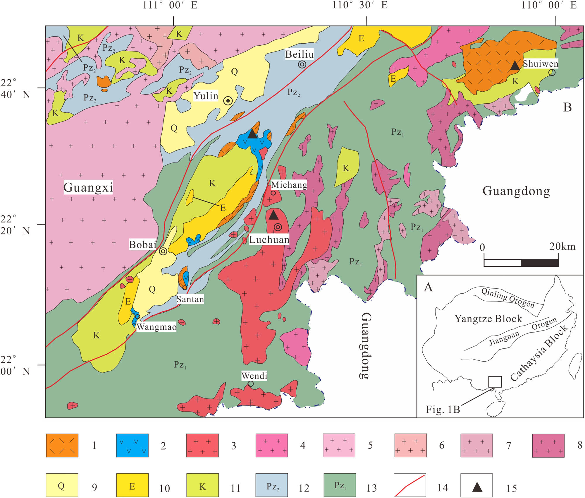
Maps of the Southeastern Guangxi (modified after reference 1): (a) the studied area in the context of the South China Block; (b) geological map of the studied area. The location of porphyroclastic lava samples in Shuiwen Basin is considered from Ref. 2. (1) Cretaceous acid volcanic rocks; (2) Cretaceous andesites; (3) Cretaceous granites; (4) Jurassic granites; (5) Indosinian granites; (6) Hercynian granites; (7) Caledonian granites; (8) neoproterozoic granites; (9) quaternary; (10) Paleogene sedimentary rocks; (11) Cretaceous sedimentary rocks; (12) late Paleozoic sedimentary rocks; (13) early Paleozoic sedimentary rocks; (14) faults; and (15) sample location.
2.2 Local geology
Volcanic activities, occurring in the Xidong Formation of the Upper Cretaceous in southeastern Guangxi, are one of the most remarkable volcanic activities in the continental margins in the northern SCS. Along the Bobai-Cenxi deep fault belt, there is an intermediate-acidic volcanic rock belt with 360 km length and 10–60 km width in the northeast-southwest direction [1]. Volcanic rocks are mainly acidic and intercalated with intermediate volcanic rocks with a thickness of 102–738 m. The volcanic rocks in Shuiwen Basin have the most extensive distribution area, which is mainly composed of tuff breccia, felsophyre, quartz porphyry and tuff. Andesites are mainly distributed in the Yulin-Bobai basin, Santan, Wangmao. It is unconformable over Devonian and Silurian Systems and is covered by sediments of Luowen Formation of the upper Cretaceous system and Paleogene system. The area of andesitic outcropping is about 38 km2 with a thickness of over 481 m. Volcanic rocks in the Yulin-Bobai basin are mainly andesites with a small amount of dacite, rhyolite and acidic tuff breccia.
The outcropping area of Luchuan batholith is 372 km2 with N-S distribution and intruded into the lower Paleozoic and Caledonian migmatite [1]. The outer contact zone is characterized by amphibolitization, greisenization, marmorization and silicatization. The batholith comprises a marginal fine-grained monzogranite and a central medium-grained monzogranite. Subsequently, felsic dykes were emplaced with several meters and lengths of several kilometers. The Rb–Sr age data of Luchuan granites is 116 Ma, belonging to the late Yanshanian plutonic rocks [1].
3 Samples and analytic methods
3.1 Petrology of the igneous rocks
The andesites in Yulin are porphyritic with phenocryst (11%–16%) of hornblende (50%–65%), pyroxene (20%–35%), plagioclase and biotite (Figure 2a–c). Hornblende and pyroxene are euhedral to subhedral with chloritization and epidotization. The matrix displays andestic texture and mainly contains subhedral plagioclase grains that surround and enclose phenocrysts.
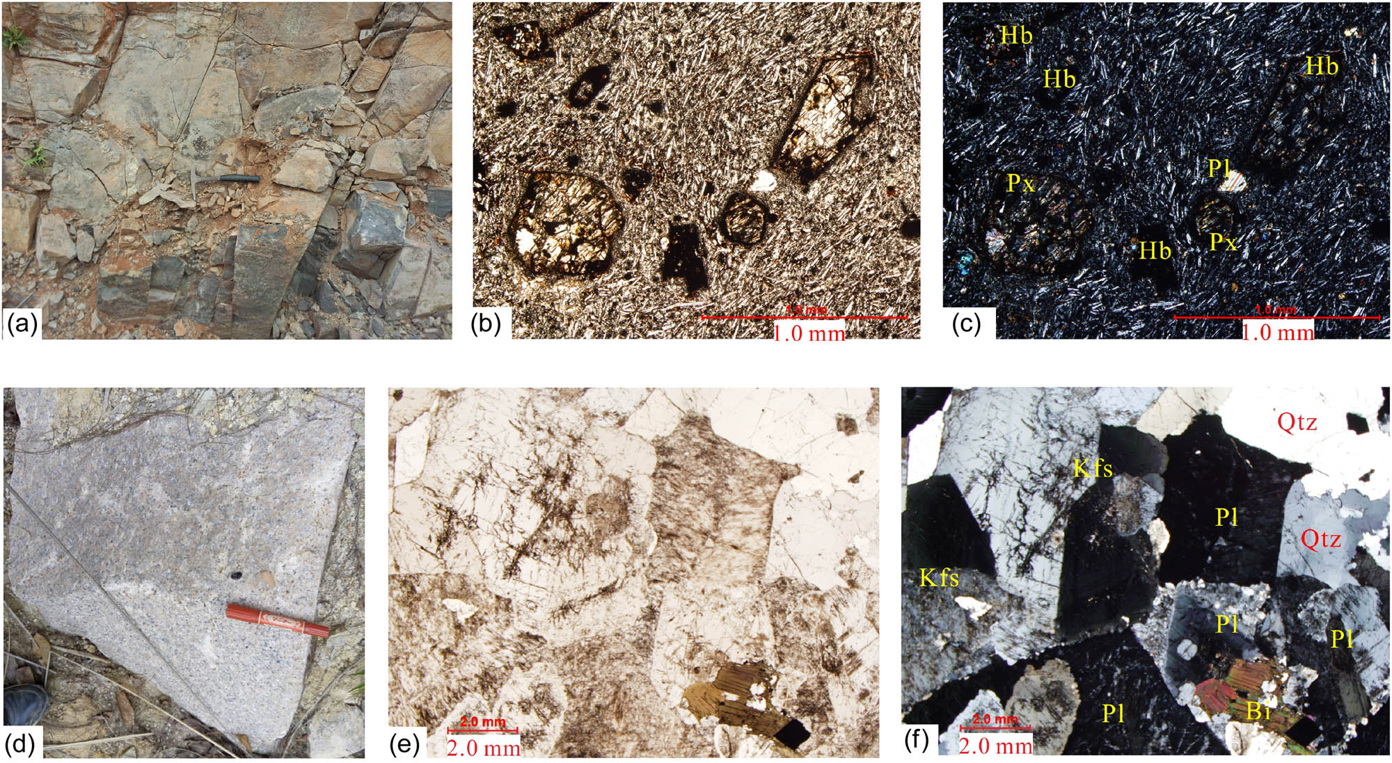
(a) Hand specimen of andesites from Yulin; (b and c) photomicrographs of andesites, containing phenocryst of hornblende, pyroxene, and plagioclase, with matrix displaying andestic texture. (d) Hand specimen of monzogranites from Luchuan; (e and f) photomicrographs of monzogranites, containing semi-euhedral plagioclase, alkali feldspar and granular quartz with minor biotite. Abbreviations: Pl, plagioclase; Hb, hornblende; Px, clinopyroxene; Qtz, quartz; Kfs, potassium feldspar; Bi, biotite.
The samples from Luchuan batholith are reddish, and the granitic texture is medium to fine grained (0.5–3 mm; Figure 2d–f). The minerals present include plagioclase (30%–35%), alkali feldspar (25%–30%) and quartz (20%–30%). Besides, trace amounts (<1%) of magnetite, apatite and zircon also occur. The plagioclase is semi-euhedral with the development of polysynthetic twinning and zoning textures, and some plagioclase is partially sericitized or kaolinized. The alkali feldspars are mainly microcline and perthite.
3.2 Zircon U–Pb analyses
Zircon grains were separated by conventional magnetic and density techniques from approximately 10 kg per sample. Then, under a binocular microscope, zircons were selected by hand-picking. By using CL images and transmitted as well as reflected light micrographs of the polished zircon grains, potential analytical spots were selected. At the Laboratory Center, Xi’an Center of Geological Survey, Xi’an, China, U–Pb isotopic analysis of the monzogranite sample was carried out with Agilent 7500a quadrupole ICP-MS. A 193 nm excimer laser was focused on the surface of the zircon grains with an energy density of 10 J/cm2. The laser beam diameter was 24 µm, and the repetition rate was 5 Hz. Helium, as a carrier gas, transported the ablation aerosol to the laser ablation inductively coupled plasma mass spectrometer (ICP-MS). Harvard zircon 91500 was used as an external standard for zircon U–Th–Pb analyses, and NIST610 was used as an external standard to calculate the contents of U, Th and Pb. Details of the analytical procedures and data processing methods are presented in Refs. [17,18]. Table 1 presents the zircon U–Pb dating results.
U–Pb data of zircon crystals from andesite sample (15LC1-1) and monzogranite sample (15LC8-1)
| 232Th (ppm) | 238U (ppm) | Th/U | Isotopic ratios | Age (Ma) | |||||||||||
|---|---|---|---|---|---|---|---|---|---|---|---|---|---|---|---|
| 207Pb/206Pb | ±1σ | 207Pb/235U | ±1σ | 206Pb/238U | ±1σ | 207Pb/206Pb | ±1σ | 207Pb/235U | ±1σ | 206Pb/238U | ±1σ | ||||
| 15LC1-1 | |||||||||||||||
| 101 | 369.9031 | 1097.415 | 0.337068 | 0.069394 | 0.000946 | 1.479264 | 0.022043 | 0.154699 | 0.001383 | 910.185 | 27.78 | 921.9289 | 9.03 | 927.2479 | 7.72 |
| 102 | 351.6855 | 814.3251 | 0.431874 | 0.073216 | 0.001017 | 1.542407 | 0.023326 | 0.152604 | 0.001137 | 1020.37 | 28.55 | 947.4655 | 9.32 | 915.5426 | 6.36 |
| 103 | 5.788257 | 722.0978 | 0.008016 | 0.151631 | 0.001552 | 8.842395 | 0.097376 | 0.422511 | 0.002668 | 2364.51 | 18.36 | 2321.876 | 10.05 | 2271.869 | 12.09 |
| 105 | 359.8538 | 1970.83 | 0.18259 | 0.060137 | 0.000686 | 0.842628 | 0.010756 | 0.10139 | 0.000711 | 609.28 | 24.07 | 620.5946 | 5.93 | 622.5516 | 4.16 |
| 106 | 375.3026 | 1075.682 | 0.348897 | 0.089175 | 0.000967 | 2.883195 | 0.032698 | 0.234226 | 0.001542 | 1409.26 | 20.83 | 1377.528 | 8.55 | 1356.609 | 8.05 |
| 107 | 213.9288 | 722.0371 | 0.296285 | 0.070226 | 0.001039 | 1.500139 | 0.025399 | 0.154576 | 0.001463 | 1000 | 29.63 | 930.4427 | 10.32 | 926.5634 | 8.17 |
| 109 | 570.043 | 870.8691 | 0.654568 | 0.072671 | 0.001129 | 1.533127 | 0.027094 | 0.152402 | 0.001352 | 1005.555 | 31.48 | 943.7524 | 10.86 | 914.4118 | 7.57 |
| 111 | 613.8774 | 895.8791 | 0.685223 | 0.097284 | 0.001131 | 3.59895 | 0.046454 | 0.267513 | 0.002156 | 1572.53 | 21.76 | 1549.3 | 10.26 | 1528.167 | 10.96 |
| 114 | 2118.73 | 662.169 | 3.199681 | 0.064143 | 0.001041 | 0.993233 | 0.015529 | 0.112186 | 0.000638 | 746.3 | 33.33 | 700.3685 | 7.91 | 685.4325 | 3.70 |
| 115 | 536.4898 | 506.6273 | 1.058944 | 0.059697 | 0.00111 | 0.838994 | 0.016053 | 0.101737 | 0.00075 | 592.31 | 40.73 | 618.5903 | 8.86 | 624.5806 | 4.39 |
| 116 | 432.4318 | 551.2917 | 0.784397 | 0.064711 | 0.001099 | 1.103915 | 0.019405 | 0.12353 | 0.000941 | 764.82 | 236.11 | 755.242 | 9.37 | 750.8499 | 5.40 |
| 104 | 778.0538 | 659.6152 | 1.179557 | 0.052943 | 0.002028 | 0.105863 | 0.00426 | 0.01455 | 0.000162 | 327.835 | 87.03 | 102.174 | 3.91 | 93.11836 | 1.03 |
| 108 | 215.2011 | 319.4118 | 0.673742 | 0.055402 | 0.005689 | 0.106484 | 0.00931 | 0.014642 | 0.000365 | 427.825 | 226.82 | 102.744 | 8.54 | 93.70662 | 2.32 |
| 110 | 784.9412 | 647.1618 | 1.212898 | 0.048431 | 0.002114 | 0.095819 | 0.004078 | 0.014437 | 0.00016 | 120.46 | 103.69 | 92.90974 | 3.78 | 92.40299 | 1.02 |
| 112 | 661.9847 | 887.1498 | 0.746193 | 0.052819 | 0.002251 | 0.105023 | 0.004352 | 0.014548 | 0.000155 | 320.43 | 98.14 | 101.4028 | 4.00 | 93.1057 | 0.98 |
| 113 | 51.65246 | 563.106 | 0.091728 | 0.047487 | 0.004553 | 0.095395 | 0.009201 | 0.014721 | 0.000308 | 72.315 | 214.79 | 92.51632 | 8.53 | 94.20726 | 1.95 |
| 117 | 807.3268 | 1006.848 | 0.801836 | 0.048714 | 0.001889 | 0.097236 | 0.003751 | 0.014577 | 0.000148 | 200.075 | 97.21 | 94.22184 | 3.47 | 93.29211 | 0.94 |
| 118 | 288.3278 | 1657.861 | 0.173916 | 0.048054 | 0.001621 | 0.097694 | 0.003339 | 0.014783 | 0.000153 | 101.94 | 84.25 | 94.64546 | 3.09 | 94.60189 | 0.97 |
| 15LC8-1 | |||||||||||||||
| B1-01 | 1224.02 | 2189.7 | 0.55899 | 0.05096 | 0.00135 | 0.11958 | 0.00349 | 0.01702 | 0.00041 | 239 | 60.16 | 114.7 | 3.17 | 108.8 | 2.58 |
| B1-02 | 240.82 | 205.99 | 1.169086 | 0.05012 | 0.00339 | 0.11282 | 0.00759 | 0.01633 | 0.00046 | 200.3 | 149.9 | 108.5 | 6.93 | 104.4 | 2.89 |
| B1-04 | 377.21 | 541.61 | 0.696461 | 0.05019 | 0.00226 | 0.10167 | 0.00464 | 0.01469 | 0.00038 | 203.6 | 101.27 | 98.3 | 4.28 | 94 | 2.4 |
| B1-05 | 1185.13 | 1832.22 | 0.646827 | 0.05097 | 0.00135 | 0.12122 | 0.00353 | 0.01725 | 0.00041 | 239.4 | 59.92 | 116.2 | 3.2 | 110.2 | 2.61 |
| B1-06 | 927.78 | 1686.72 | 0.55005 | 0.04853 | 0.00154 | 0.11615 | 0.00391 | 0.01736 | 0.00042 | 125.3 | 73.06 | 111.6 | 3.56 | 110.9 | 2.68 |
| B1-07 | 500.14 | 727.1 | 0.687856 | 0.0474 | 0.00179 | 0.10642 | 0.00415 | 0.01628 | 0.0004 | 68.8 | 87.96 | 102.7 | 3.81 | 104.1 | 2.57 |
| B1-08 | 309.7 | 517.63 | 0.598304 | 0.04942 | 0.0025 | 0.11305 | 0.00575 | 0.01659 | 0.00044 | 167.8 | 114.11 | 108.8 | 5.25 | 106.1 | 2.77 |
| B1-11 | 500.86 | 398.46 | 1.256989 | 0.0681 | 0.00443 | 0.14706 | 0.00944 | 0.01566 | 0.00045 | 871.5 | 129.29 | 139.3 | 8.36 | 100.2 | 2.88 |
| B1-12 | 233.53 | 282.46 | 0.826772 | 0.04427 | 0.00449 | 0.09972 | 0.01005 | 0.01634 | 0.00048 | 0.1 | 136.52 | 96.5 | 9.28 | 104.5 | 3.08 |
| B1-13 | 703.94 | 1152.84 | 0.610614 | 0.04828 | 0.00187 | 0.11383 | 0.00454 | 0.0171 | 0.00043 | 112.8 | 88.86 | 109.5 | 4.14 | 109.3 | 2.71 |
| B1-14 | 491.27 | 671.18 | 0.73195 | 0.04844 | 0.00228 | 0.10967 | 0.00522 | 0.01642 | 0.00043 | 121 | 107.39 | 105.7 | 4.78 | 105 | 2.7 |
| B1-15 | 696.33 | 960.37 | 0.725064 | 0.05266 | 0.00208 | 0.12145 | 0.00492 | 0.01672 | 0.00042 | 314.2 | 87.28 | 116.4 | 4.45 | 106.9 | 2.66 |
| B1-16 | 1127.74 | 1979.13 | 0.569816 | 0.04781 | 0.00153 | 0.11456 | 0.00388 | 0.01738 | 0.00042 | 89.1 | 75.26 | 110.1 | 3.54 | 111.1 | 2.68 |
| B1-17 | 549.77 | 391.71 | 1.403513 | 0.05741 | 0.00565 | 0.1359 | 0.01309 | 0.01717 | 0.00059 | 507 | 203.5 | 129.4 | 11.7 | 109.7 | 3.72 |
| B1-18 | 415.41 | 258.21 | 1.608807 | 0.05492 | 0.00507 | 0.1218 | 0.01102 | 0.01608 | 0.00053 | 408.8 | 194.25 | 116.7 | 9.97 | 102.9 | 3.35 |
| B1-19 | 924.99 | 1745.1 | 0.53005 | 0.05128 | 0.00172 | 0.11495 | 0.00405 | 0.01626 | 0.0004 | 253.5 | 75.49 | 110.5 | 3.69 | 104 | 2.53 |
| B1-20 | 845.93 | 2001.5 | 0.422648 | 0.05076 | 0.00156 | 0.11992 | 0.00394 | 0.01713 | 0.00041 | 230.1 | 69.69 | 115 | 3.57 | 109.5 | 2.63 |
| B1-21 | 411.87 | 661.11 | 0.622998 | 0.04843 | 0.00229 | 0.11506 | 0.00551 | 0.01723 | 0.00044 | 120.4 | 107.71 | 110.6 | 5.01 | 110.1 | 2.8 |
| B1-22 | 892.02 | 1638 | 0.544579 | 0.04929 | 0.00181 | 0.11203 | 0.00425 | 0.01648 | 0.00041 | 161.7 | 83.51 | 107.8 | 3.88 | 105.4 | 2.6 |
| B1-23 | 919.05 | 2210.6 | 0.415747 | 0.05108 | 0.00149 | 0.12198 | 0.00382 | 0.01732 | 0.00042 | 244.4 | 65.84 | 116.9 | 3.46 | 110.7 | 2.64 |
| B1-24 | 484.64 | 446.11 | 1.086369 | 0.04966 | 0.00235 | 0.11423 | 0.00549 | 0.01668 | 0.00043 | 179.3 | 106.88 | 109.8 | 5 | 106.6 | 2.7 |
| B1-25 | 372.44 | 316.27 | 1.177601 | 0.04944 | 0.0036 | 0.11618 | 0.00838 | 0.01704 | 0.00048 | 168.8 | 161.55 | 111.6 | 7.62 | 108.9 | 3.07 |
3.3 Whole-rock geochemistry
Major elements were analyzed by X-ray fluorescence (Axios max) at the Hebei Institute of Geology and Mineral Resources, China Geological Survey. Analytical precision was generally better than 5% for most oxides. Trace element data were also measured by an ICP-MS with the use of a X Serise 2 machine. The analytical precisions for most trace elements are higher than 3%. Table 2 presents samples’ major and trace elemental data.
Major element (wt%) and trace element (ppm) compositions of the Cretaceous magmatic rocks in Southeast Guangxi
| Andesites | Monzogranites | |||||||
|---|---|---|---|---|---|---|---|---|
| 15LC1-1 | 15LC4-1 | 15LC2-1 | 15LC2-2 | 15LC7-1 | 15LC8-1 | 15LC-H2 | 15LC-H3 | |
| SiO2 | 54.67 | 54.07 | 54.39 | 54.31 | 77.17 | 75.72 | 78.04 | 77.80 |
| Al2O3 | 15.72 | 15.16 | 15.48 | 15.46 | 12.34 | 12.88 | 11.41 | 12.16 |
| TiO2 | 0.81 | 0.80 | 0.80 | 0.80 | 0.08 | 0.14 | 0.14 | 0.08 |
| Fe2O3 | 3.44 | 3.58 | 4.35 | 4.48 | 0.33 | 0.42 | 0.48 | 0.24 |
| FeO | 3.32 | 3.72 | 3.02 | 2.96 | 0.20 | 0.42 | 0.33 | 0.23 |
| CaO | 7.83 | 7.54 | 7.35 | 7.32 | 0.61 | 0.95 | 0.61 | 0.51 |
| MgO | 7.61 | 8.28 | 7.84 | 7.85 | 0.07 | 0.19 | 0.19 | 0.09 |
| K2O | 2.06 | 2.02 | 2.05 | 2.09 | 4.56 | 5.22 | 4.95 | 4.53 |
| Na2O | 2.80 | 2.88 | 2.83 | 2.88 | 3.90 | 3.40 | 2.95 | 3.80 |
| MnO | 0.13 | 0.12 | 0.13 | 0.12 | 0.071 | 0.041 | 0.031 | 0.044 |
| P2O5 | 0.17 | 0.17 | 0.17 | 0.17 | 0.011 | 0.022 | 0.023 | 0.011 |
| LOI | 1.24 | 1.47 | 1.37 | 1.33 | 0.64 | 0.57 | 0.77 | 0.49 |
| Total | 99.80 | 99.80 | 99.77 | 99.77 | 99.99 | 99.96 | 99.92 | 99.99 |
| FeOT | 6.42 | 6.94 | 6.93 | 6.99 | 0.50 | 0.79 | 0.77 | 0.45 |
| Mg# | 67.88 | 68.03 | 66.85 | 66.67 | 20.89 | 29.98 | 30.55 | 25.44 |
| A/CNK | 0.75 | 0.73 | 0.76 | 0.76 | 0.99 | 0.99 | 1.01 | 1.01 |
| Sc | 22.2 | 23.2 | 25.4 | 20.3 | 6.64 | 2.95 | 2.69 | 5.92 |
| V | 174 | 163 | 146 | 142 | 8.01 | 12.6 | 18.9 | 8.02 |
| Cr | 369 | 353 | 424 | 415 | 0.49 | 12.0 | 2.96 | 1.43 |
| Co | 33.1 | 34.3 | 34.6 | 33.8 | 0.084 | 2.10 | 0.62 | 0.09 |
| Ni | 147 | 148 | 134 | 128 | 0.074 | 4.37 | 0.78 | 0.17 |
| Ga | 16.7 | 16.7 | 17.8 | 17.3 | 17.6 | 15.9 | 13.4 | 19.8 |
| Rb | 61.3 | 65.0 | 66.2 | 65.1 | 432 | 250 | 233 | 488 |
| Sr | 530 | 533 | 509 | 515 | 12.8 | 102 | 76.9 | 12.9 |
| Zr | 164 | 125 | 167 | 164 | 58.7 | 90.6 | 103 | 58.6 |
| Hf | 4.51 | 3.35 | 4.40 | 4.30 | 4.41 | 4.99 | 5.68 | 4.45 |
| Nb | 8.97 | 8.73 | 8.04 | 8.27 | 57.5 | 18.3 | 13.4 | 37.2 |
| Ta | 0.90 | 0.50 | 0.51 | 0.51 | 3.47 | 1.31 | 1.05 | 2.61 |
| Th | 8.00 | 7.89 | 7.51 | 7.36 | 26.2 | 38.0 | 40.8 | 28.1 |
| U | 1.81 | 1.73 | 1.59 | 1.48 | 30.5 | 9.20 | 7.62 | 19.8 |
| Pb | 12.7 | 12.4 | 13.0 | 11.0 | 72.0 | 45.2 | 41.5 | 65.5 |
| Ba | 570 | 589 | 549 | 556 | 28.7 | 176 | 185 | 38.3 |
| Y | 16.5 | 13.1 | 17.2 | 17.5 | 28.7 | 12.4 | 9.87 | 17.2 |
| La | 28.7 | 24.3 | 27.0 | 26.7 | 20.0 | 38.6 | 33.8 | 19.5 |
| Ce | 51.8 | 40.6 | 49.9 | 50.7 | 41.5 | 59.4 | 56.1 | 36.9 |
| Pr | 6.44 | 5.25 | 6.13 | 6.12 | 4.88 | 6.59 | 6.00 | 4.05 |
| Nd | 24.5 | 19.5 | 24.0 | 23.4 | 15.3 | 20.2 | 18.3 | 11.8 |
| Sm | 4.41 | 3.51 | 4.38 | 4.39 | 2.98 | 2.91 | 2.49 | 1.99 |
| Eu | 1.11 | 0.87 | 1.23 | 1.25 | 0.06 | 0.41 | 0.36 | 0.08 |
| Gd | 3.51 | 2.89 | 3.77 | 3.82 | 2.58 | 2.66 | 2.34 | 1.90 |
| Tb | 0.62 | 0.49 | 0.58 | 0.60 | 0.51 | 0.39 | 0.31 | 0.32 |
| Dy | 3.19 | 2.50 | 3.25 | 3.27 | 3.20 | 1.85 | 1.50 | 1.93 |
| Ho | 0.63 | 0.50 | 0.62 | 0.62 | 0.82 | 0.42 | 0.32 | 0.49 |
| Er | 1.73 | 1.35 | 1.76 | 1.77 | 2.78 | 1.25 | 1.02 | 1.68 |
| Tm | 0.31 | 0.25 | 0.28 | 0.27 | 0.69 | 0.26 | 0.20 | 0.43 |
| Yb | 1.80 | 1.52 | 1.81 | 1.82 | 4.86 | 1.54 | 1.23 | 3.09 |
| Lu | 0.45 | 0.40 | 0.26 | 0.27 | 0.89 | 0.25 | 0.22 | 0.63 |
| ∑REE | 129.15 | 104.00 | 125.05 | 125.05 | 100.96 | 136.67 | 124.14 | 84.77 |
| δEu | 0.84 | 0.81 | 0.90 | 0.91 | 0.06 | 0.45 | 0.45 | 0.13 |
| LREE/HREE | 9.55 | 9.50 | 9.13 | 9.06 | 5.19 | 14.86 | 16.38 | 7.11 |
| (La/Yb)N | 6.80 | 6.54 | 10.97 | 10.65 | 2.41 | 16.23 | 16.28 | 3.35 |
| Rb/Sr | 0.12 | 0.12 | 0.13 | 0.13 | 33.68 | 2.44 | 3.03 | 37.97 |
| Ba/La | 19.88 | 24.22 | 20.31 | 20.80 | 1.44 | 4.57 | 5.47 | 1.96 |
| Zr/Hf | 36.48 | 37.25 | 38.02 | 38.21 | 13.30 | 18.16 | 18.17 | 13.18 |
| Sr/Y | 32.09 | 40.82 | 29.53 | 29.34 | 0.45 | 8.25 | 7.79 | 0.75 |
4 Results
4.1 Zircon U–Pb ages
Zircon CL images reveal that the zircon crystals were mostly colorless and semi-euhedral. Most are of short-column or sub-rounded shape with a length-to-width ratio of about 1:1–1:3. The zircons display typical magmatic oscillatory zoning and rhythmically zoned texture. The Th/U ratios of the five youngest zircon crystals are between 0.09 and 1.21 (Table 1), six of which are bigger than 0.10 and are within the range of typical igneous zircons [19]. The seven youngest zircon crystals together yield a weighted mean 206Pb/238U age of 93.38 ± 0.83 Ma (2σ) (MSWD = 0.47; Table 1 and Figure 3), the early stage of late Cretaceous.
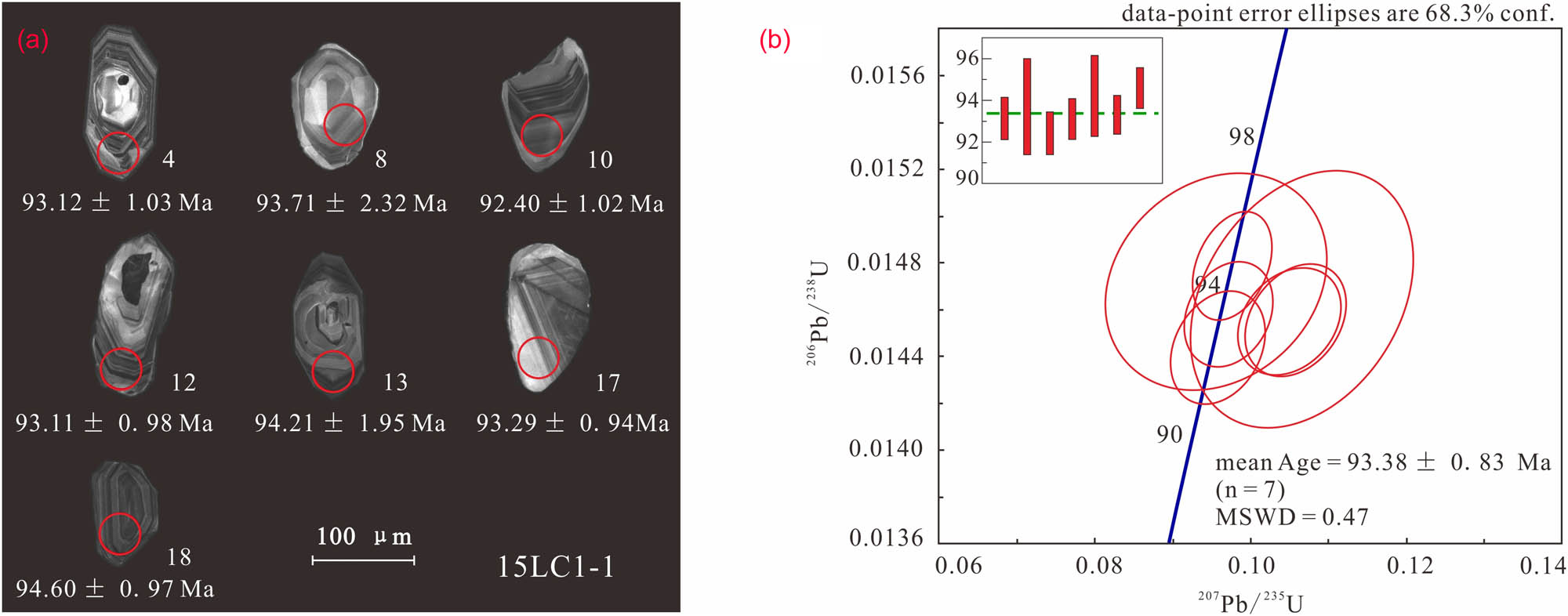
Cathodoluminescence images and U–Pb ages of zircons from Yulin andesites. The red circles indicate the analytical area for U–Pb dating, and age error is given at 2 sigma level.
Zircons are abundant in the studied monzogranite samples. Zircons are euhedral and range up to 100 µm in size; most of them are transparent to light brown in color and exhibit magmatic oscillatory zoning. Twenty-five grains were analyzed from sample 15LC8-1, of which 19 may be pooled to yield a weighted mean 206Pb/238U age of 107.6 ± 1.2 Ma (2σ) (MSWD = 0.96; Table 1 and Figure 4). The other Cretaceous igneous rocks’ ages are from 113 to 83 Ma in southeastern Guangxi [2,7,10,20], indicating that the Cretaceous igneous rocks crystallized from late early Cretaceous to early late Cretaceous in the studied area.
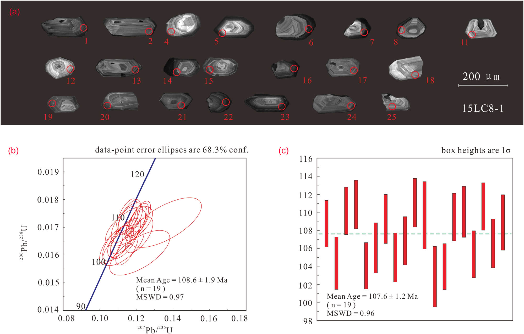
Cathodoluminescence images and U–Pb ages of zircons from Luchuan monzogranites. The red circles indicate the analytical area for U–Pb dating, and age error is given at 2 sigma level.
4.2 Whole-rock major and trace elements
These monzogranites are compositionally similar to each other and are characterized by high SiO2 and low Al2O3, FeOT, P2O5, TiO2, MgO and CaO. Total alkalis and K2O/Na2O values of samples are high, with the characteristic of high-K calc-alkaline rocks (Figure 5a and b). They are metaluminous-weakly peraluminous with A/CNK values (molar Al2O3/[CaO + K2O + Na2O], 0.99–1.04, Figure 5c). Andesites fall within the range of basaltic andesites (Figure 5a), with low K2O/Na2O values. They are high-magnesian andesites (HMAs), significantly characterized by high MgO and high Mg contents. The HMAs are calc-alkaline similar to clastoporphyritic lava (Figure 5b).
![Figure 5 (a) Geochemical classification diagrams for Cretaceous magmatic rocks in southeastern Guangxi: plot of Na2O + K2O versus SiO2 (after reference 26). The green line between alkaline and sub-alkaline igneous rocks is taken from Ref. 27; (b) diagram of SiO2 versus K2O (after reference 28); and (c) A/NK versus A/CNK diagram (after reference 29). A/NK: molar Al2O3/[K2O + Na2O]; A/CNK: molar Al2O3/[CaO + K2O + Na2O]. The data of porphyroclastic lava are from Reference 2.](/document/doi/10.1515/geo-2020-0160/asset/graphic/j_geo-2020-0160_fig_005.jpg)
(a) Geochemical classification diagrams for Cretaceous magmatic rocks in southeastern Guangxi: plot of Na2O + K2O versus SiO2 (after reference 26). The green line between alkaline and sub-alkaline igneous rocks is taken from Ref. 27; (b) diagram of SiO2 versus K2O (after reference 28); and (c) A/NK versus A/CNK diagram (after reference 29). A/NK: molar Al2O3/[K2O + Na2O]; A/CNK: molar Al2O3/[CaO + K2O + Na2O]. The data of porphyroclastic lava are from Reference 2.
The
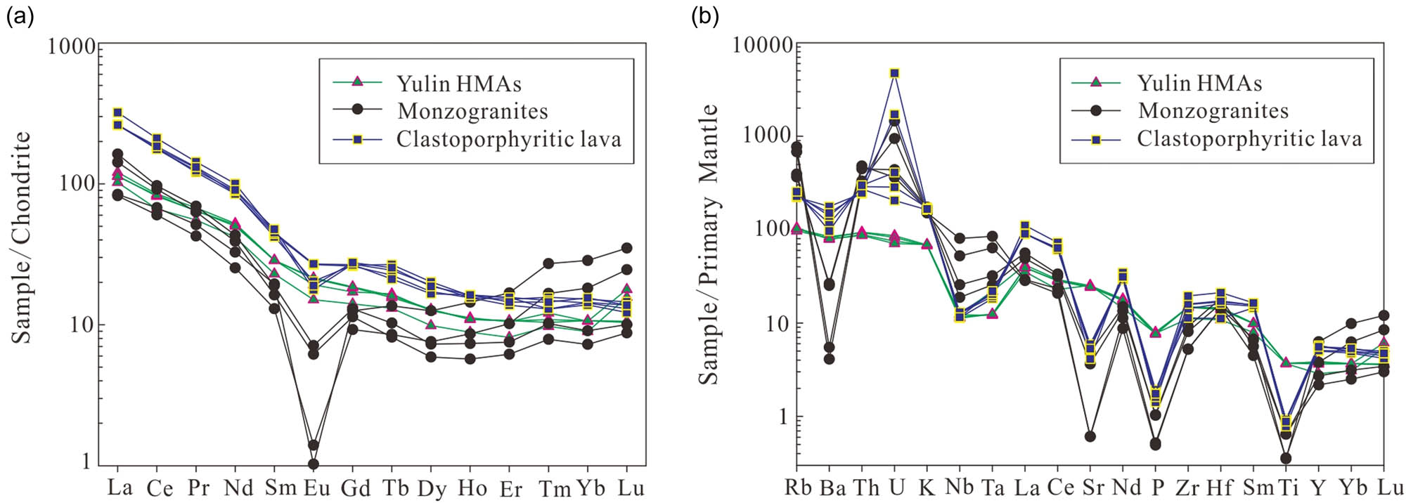
(a) Chondrite-normalized REE patterns and (b) the primary-mantle-normalized trace elements spider diagrams for Cretaceous magmatic rocks in southeastern Guangxi. Normalizing values are taken from Ref. 30.
In the primitive-mantle-normalized spidergram, all the samples have similar distribution patterns (Figure 6b), showing enrichment in large ion lithophile elements (LILEs; such as Rb, Th and K) while depletion or negative anomaly in high-field strength elements (HFSEs; such as Nb, Ti, Sr and P). The phenomenon of the “TNT (Ti-Nb-Ta) anomaly” was most characteristic of island arc volcanics and the continental crust in general [21].
5 Discussion
5.1 Samples’ tectonic implications
The ratios of HFSEs in magmatic rocks can accurately reflect the characteristics of the magmatic sources. With high Rb/Sr ratios, and low Ba/La as well as Zr/Hf ratios, monzogranites and clastoporphyritic lava are mainly crust derived. Granitic rocks can be categorized into the following four main genetic types: M-type, I-type, S-type and A-type. With low (Zr + Nb + Ce + Y) and A/CNK values, the monzogranites and clastoporphyritic lava are similar to I-type granites without alkaline dark-colored minerals (Figure 7a). Moreover, I-type granites are formed by partial melting of intermediate-basic metamorphic igneous rocks of the crust [22]. In the Rb versus (Yb + Ta) discriminant diagrams (Figure 7b), monzogranites and clastoporphyritic lava samples are plotted in the volcanic arc granites and syn-collisional granites, which indicates that the formation of monzogranites and clastoporphyritic lava is closely related to the subduction.
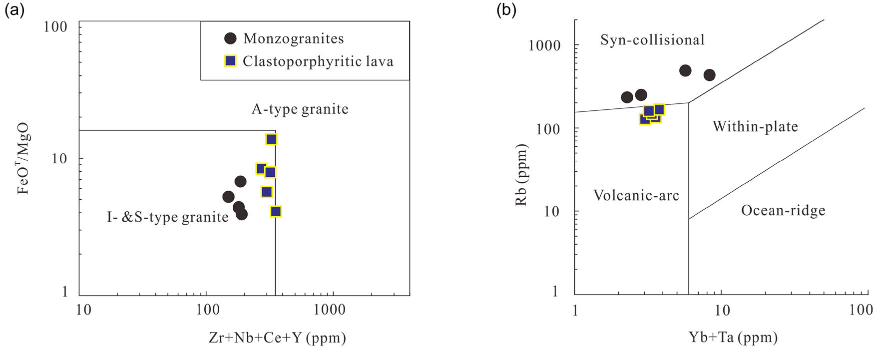
Tectonic discriminant diagrams of Cretaceous monzogranites and clastoporphyritic lava in southeastern Guangxi: (a) Zr + Nb + Ce + Y versus FeOT/MgO plot for the identification of A-type granites from I- and S-type granites (after Ref. 31); (b) Yb + Ta versus Rb plot for discriminating syn-collisional granites, volcanic-arc granites, within-plate granites and ocean-ridge granites (after Ref. 32).
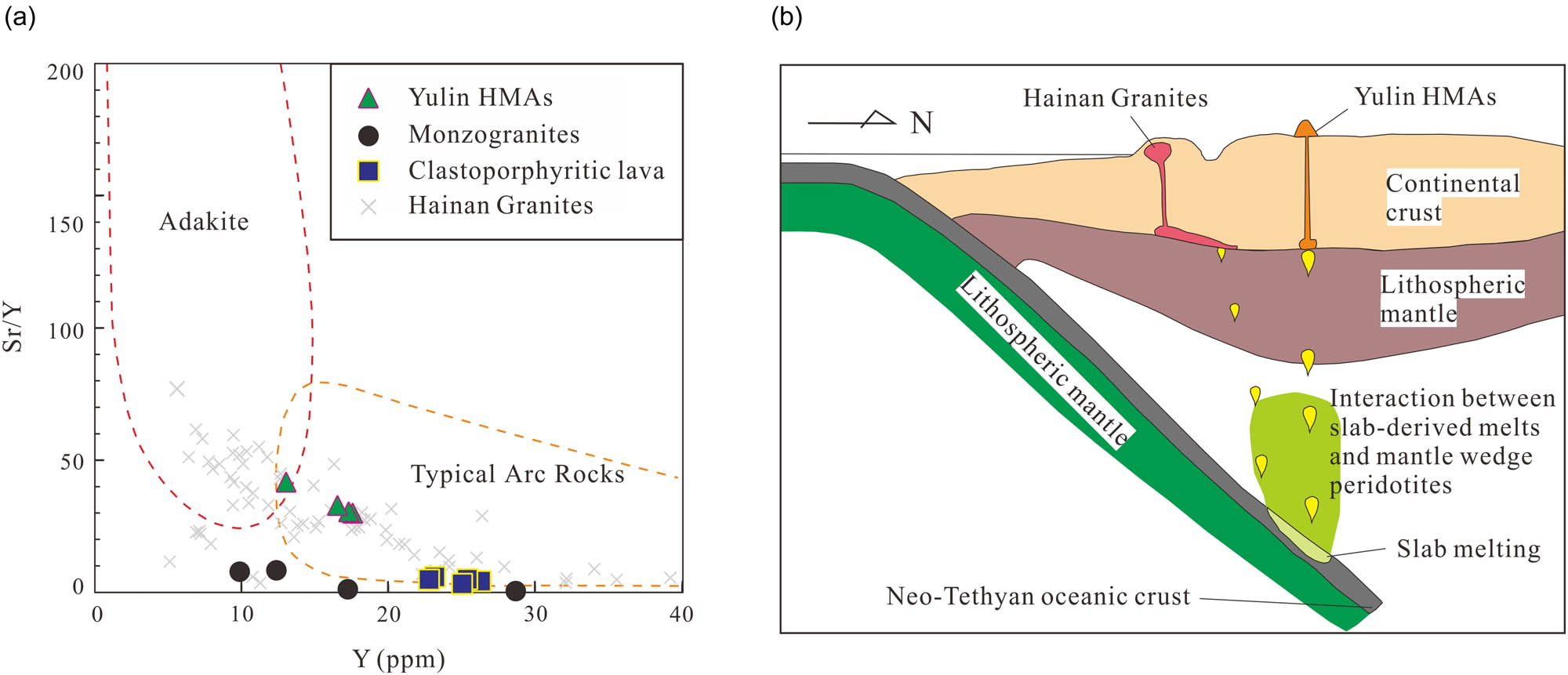
HMAs are mostly formed in a convergent plate boundary. HMAs in Yulin share similar geochemical characteristics with bajaites in Baja California Peninsula, Mexico, such as the high fractionation of light and heavy rare earth elements and the high contents of Sr, Cr, Ni, V and Co. It indicates that the HMAs in Yulin, like the bajaites, was formed in a convergent tectonic environment with probable origin by melting of mantle peridotites previously metasomatized by slab melts [23]. Besides, magmatites with similar geochemical characteristics of HMAs are found in Gangdese Belt contemporaneously [24,25], which means that Neo-Tethys extended to the present location of SCS and the tectonic environment in the northern margin of SCS was affected by the subduction of Neo-Tethys during Cretaceous.
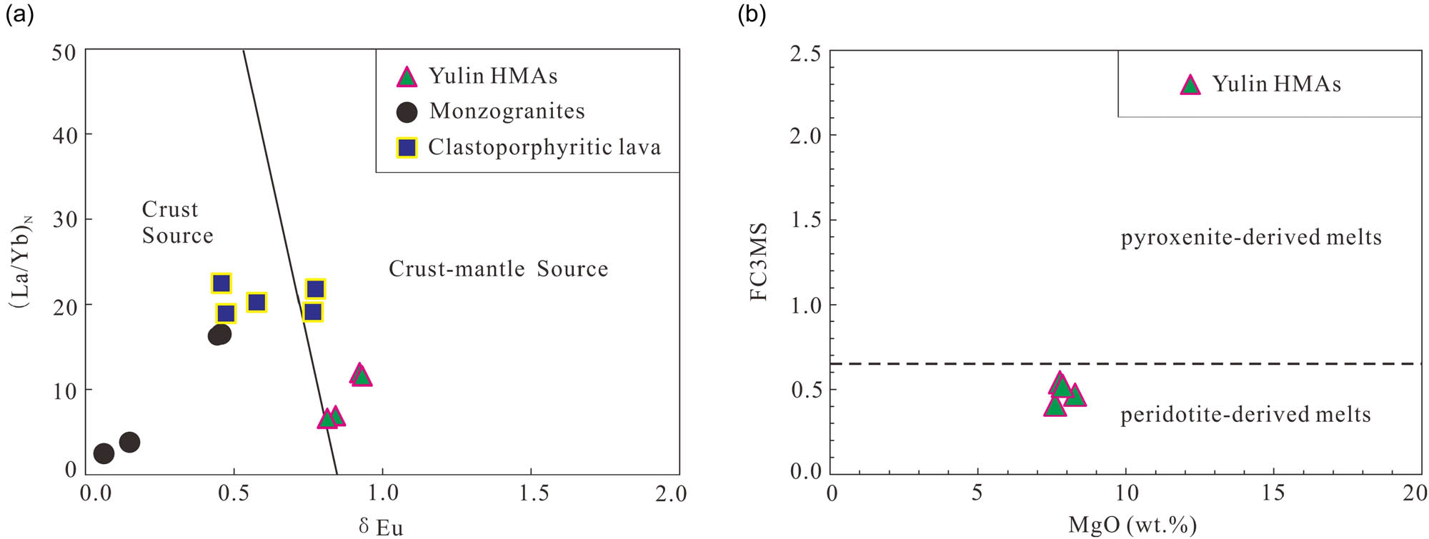
The ratios of HFSEs in magmatic rocks can accurately reflect the characteristics of magmatic source. HMAs have lower Rb/Sr ratios, higher Ba/La and Zr/Hf ratios. In Figure 8a, showing the picture of (La/Yb)N versus δEu, the magma source of HMAs is crust mantle derived, while the clastoporphyritic lava and monzogranites are mainly crust derived. The differentiation degree of monzogranites’ magma, especially the medium-grained monzogranites’, is much higher with lower (La/Yb)N. These geochemical characteristics indicate that the andesitic magma is obviously mixed with mantle source. Besides, the HMAs in Yulin have low FC3MS values lower than 0.65, suggesting peridotitic sources (Figure 8b).
5.2 Cretaceous magmatism’s geochronology and regional tectonics in southwestern South China Block
Beside the magmatism in southeastern Guangxi, there are numerous igneous rocks in Cretaceous, which can be found in the surrounding area, such as Yangchun Basin, western Guangxi, eastern Yunnan and northern Vietnam [4,35,36,37,38,39,40,41]. The ages of those rocks are from 113 to 70 Ma, similar to samples in southeastern Guangxi. Furthermore, Cretaceous ore mineralization is often related to those igneous rocks, especially granitoids. So it is a meaningful period for magma and mineralization from late early Cretaceous to early late Cretaceous in southwestern South China Block.
The volcanic rocks during this period in the northern continental margin of the SCS are mainly concentrated in the Yunkai region at the border of Guangdong and Guangxi, and there are a lot of extrusive rocks in Hainan island mainly in early Cretaceous. Most of them are most intermediate-acid volcanic rocks and seldom basic volcanic rocks, which do not conform to the “bimodal igneous rock assemblages” in Southeastern China, especially in late Cretaceous. Besides, according to zircon solubility simulation formula at 700–1,300°C [42], the diagenetic temperature of clastoporphyritic lava in Shuiwen basin clastoporphyritic lava is 764–812°C, much lower than that of the clastoporphyritic lava in Zhejiang (803–820°C) and rhyolite in Fujian (861–930°C) [43,44]. Moreover, the diagenetic temperature of monzogranites in Luchuan is 706–754°C, much lower than the average diagenetic temperature of I-type granites (781°C) [45]. Cretaceous S-type granites have also been discovered in southeastern Guangxi in recent years, such as Youmapo muscovite granites [46], which is also different from the assemblages of I-type and A-type granites in Zhejiang and Fujian. From late early Cretaceous to early late Cretaceous, the subduction of the paleo-Pacific plate only influences the area east of Wuyi Mountain [35,47]. Therefore, it may not be suitable to mechanically apply the tectonic model in Zhejiang and Fujian to the southeastern Guangxi during this period. The assemblage of I- and S-type granites is suggested the symbol of convergent environment [48], which also differs from the extensional environment in Southeast China.
In recent years, studies on the influence of the Tethyan subduction on the northern continental margin of the SCS increased [36,49,50,51,52,53,54]. In the northern part of the SCS and nearby area, there was an E-W trending magmatic belt, and the northern continental margin of the SCS was in the tectonic environment of the Tethyan subduction in Cretaceous [35,37,38,55]. These Cretaceous igneous rocks in Guangxi and Hainan islands are the product of northward subduction of Neo-Tethys. Moreover, HMAs in Guangxi and adakitic rocks in Hainan should form in subduction settings and be produced by partial melting of subducting young and hot slabs followed by interaction with the overlying mantle during ascent [56,57,58,59,60,61] (Figure 9). Due to the relatively young and high temperature of the subducted oceanic crust when Tethyan ridge subducted underneath South China Block [38,55], or tearing and breaking off, the subducted oceanic crust would melt, and the melt replaced mantle wedge and crustal materials in southeastern Guangxi to form Cretaceous magmatic rocks in this region, which share similarities with HMAs and adakitic rocks in Gangdese magmatic arc at a similar time [24,25,62,63,64]. In this case, andesites in Yulin were characterized by high magnesium content, almost at the same time that adakitic rocks formed in Hainan island. As the same with those igneous rocks in Gangdese belt, magmatisms from both southwestern South China Block and Gangdese magmatic arc may generate under the subduction of Neo-Tethyan ridge during the middle period of Cretaceous. Neo-Tethyan subduction influences both magmatic activity and mineralization in southwestern South China Block.
6 Conclusions
Yulin andesites and Luchuan monzogranites are emplaced at 93.37 ± 0.43 Ma and 107.6 ± 1.2 Ma, respectively. There is intense magmatic activity occurring in the late early Cretaceous to early late Cretaceous in southeastern Guangxi. The andesites exhibit high MgO and Mg#, enriched in Sr, Cr, Ni, V and Co, which imply that Cretaceous andesites belong to HMAs with similarity with bajaites. Luchuan granites are monzogranites and are highly differentiated I-type granites. These Cretaceous magmatic rocks are enriched in LREEs and LILEs, but depleted in HFSEs. The formation of Yulin HMAs, Luchuan batholith and Shuiwen clastoporphyritic lava is associated with subduction. Different from the NE-trending magmatic belt under the subduction of paleo-Pacific along the east coast of the South China Block, the northern continental margin of the SCS is in the tectonic environment of the Tethyan subduction during the Cretaceous. The subduction of Neo-Tethyan ridge may contribute to magmatism.
Acknowledgments
This research was supported by the National Natural Science Foundation of China (Grant No. 41572207, 41276047, 41030853). The authors acknowledge Yongyang Huang from the Institute of Guangzhou Marine Geological Survey and Guangxi Institute of Marine Geological Survey their support during the field investigation. The authors are grateful to the editor and the anonymous referees for constructive review comments. The authors thank Hailing Zhao and Dapeng Li from the China University of Geosciences, Beijing, for their helpful discussions.
Conflict of interest: No potential conflict of interest was reported by the authors.
Author contributions: Yang Liu: fieldwork; analysis of petrology, U–Pb ages and geochemical data of samples; and original draft. Nianqiao Fang: fieldwork; funding acquisition; and review and editing of manuscript. Menglin Qiang: methodology and analysis of petrology, U–Pb ages and geochemical data of samples. Lei Jia: fieldwork and analysis of petrology of samples. Chaojie Song: visualization and curation of data.
Data availability statement: All data related to the research have appeared in the article and can be available upon request to the corresponding author.
References
[1] Guangxi Bureau of Geology, Mineral Prospecting and Exploitation. Geological records of Guangxi Zhuang autonomous region. Beijing: Geological Publishing House; 1985, (in Chinese).Suche in Google Scholar
[2] Pan D, Wu RG, Deng WQ, Xie J X, Zhang ZS. LA-ICP-MS zircon U–Pb dating and geochemical characteristics of clastoporphyritic lava in Shuiwen Basin. J East China Inst Technol. 2013;36(1):25–34, (in Chinese with English abstract).Suche in Google Scholar
[3] Cai MH, He LQ, Liu GQ, Wu DC, Huang HM. SHRIMP zircon U–Pb dating of the intrusive rocks in the Dachang Tin-polymetallic ore field, Guangxi and their geological significance. Geol Rev. 2006;52(3):409–14, (in Chinese with English abstract).Suche in Google Scholar
[4] Xu R, Deng J, Cheng H, Cui X, Wang C. Geochronology, geochemistry and geodynamic setting of Late Cretaceous magmatism and Sn mineralization in the western South China and Tengchong-Baoshan. Acta Petrol Sin. 2018;34(5):1271–84, (in Chinese with English abstract).Suche in Google Scholar
[5] Huang W, Liang H, Zhang J, Wu J, Chen X, Ren L. Genesis of the Dachang Sn-polymetallic and Baoshan Cu ore deposits, and formation of a Cretaceous Sn–Cu ore belt from southwest China to western Myanmar. Ore Geol Rev. 2019;112:1–17.10.1016/j.oregeorev.2019.103030Suche in Google Scholar
[6] Wang T, Li G, Wang Q, Santosh M, Zhang Q, Deng J. Petrogenesis and metallogenic implications of late Cretaceous I- and S-type granits in Dachang-Kunlunguan ore belt, Southwestern South China Block. Ore Geol Rev. 2019;113:1–15.10.1016/j.oregeorev.2019.103079Suche in Google Scholar
[7] Wang JH, Wang ZQ, Chen B. Geochronology, petrology, geochemistry and Nd isotopic constraints on the origin of the Sanchachong tungsten-related pluton, Guangxi, South China. Geochimica. 2014;6:549–73, (in Chinese with English abstract).Suche in Google Scholar
[8] Fu Q, Ge WS, Wen CS, Cai KQ, Li SF, Zhang ZW, et al. Geochemistry and genesis of Michang granites and their dark microgranular enclaves in Guangxi. Acta Geosci Sin. 2011;3:293–303, (in Chinese with English abstract).Suche in Google Scholar
[9] Wang ZQ, Chen B, Ma XH. Multiple magmatism in the Luchuan–Bobai metallogenic belt of Guangxi and its relationship with W–Mo mineralization. Acta Geol Sin. 2017;91(2):421–39, (in Chinese with English abstract).Suche in Google Scholar
[10] Yang QJ, Sun MH, Qin A, Zhang QW. Study on geochronology and geological significance of Dali granitoids of Dayaoshan, Guangxi. Min Resour Geol. 2017;31(5):843–53, (in Chinese with English abstract).Suche in Google Scholar
[11] Hu SQ, Zhou GF, Peng SB, Zhang XJ, Yi SH, Tang GS. Chronology and geochemical characteristics of quartz monzonite (porphyry) in the Dali copper-molybdenum deposit and its geological significance. Acta Geosci Sin. 2012;33(1):23–37, (in Chinese with English abstract).Suche in Google Scholar
[12] Tan J, Wei JH, Li SR, Wang ZM, Fu LB, Zhang KQ. Geochemical characteristics and tectonic significance of Kunlunguan A-type granite, Guangxi. Earth Sci J China Univ Geosci. 2008;33(6):743–54, (in Chinese with English abstract).Suche in Google Scholar
[13] Fu L, Wei J, Li Y, Tan J, Li S, Li H. LA-ICP-MS zircon U–Pb dating of the Kunlunguan A-type granites in Guangxi Province, South China and its geological significance. Chinese J Geochem. 2010;29(3):223–32.10.1007/s11631-010-0450-xSuche in Google Scholar
[14] Liang T, Wang DH, Hou KJ, Li HQ, Huang HM, Cai MH, et al. LA-MC-ICP-MS zircon U–Pb dating of Longxianggai pluton in Dachang of Guangxi and its geological significance. Acta Petrol Sin. 2011;27(6): 1624–36, (in Chinese with English abstract).Suche in Google Scholar
[15] Luo JH, Che ZC, Guo AL, Cheng SY, Pei XZ. Late Cretaceous lithospheric extension in the Nandan–Hechi tectonic zone of northern Guangxi Province and its influence on hydrocarbon accumulation conditions. Oil Gas Geol. 2009;30(5):619–25, (in Chinese with English abstract).Suche in Google Scholar
[16] Zhang KX, Pan GT, He WH, Xiao QH, Xu YD, Zhang ZY, et al. New division of tectonic-strata superregion in China. Earth Sci J China Univ Geosci. 2015;40(2):206–33.Suche in Google Scholar
[17] Song S, Niu Y, Wei C, Ji J, Su L. Metamorphism, anatexis, zircon ages and tectonic evolution of the Gongshan block in the northern Indochina continent – an eastern extension of the Lhasa Block. Lithos. 2010;120(3–4):327–46.10.1016/j.lithos.2010.08.021Suche in Google Scholar
[18] Liu YS, Hu ZC, Gao S, Günther D, Xu J, Gao CG, et al. In situ analysis of major and trace elements of anhydrous minerals by LA-ICP-MS without applying an internal standard. Chem Geol. 2008;257(1–2):34–43.10.1016/j.chemgeo.2008.08.004Suche in Google Scholar
[19] Belousova E, Griffin W, O’Reilly SY, Fisher N. Igneous zircon: trace element composition as an indicator of source rock type. Contribut Min Petrol. 2002;143(5):602–22.10.1007/s00410-002-0364-7Suche in Google Scholar
[20] Wang YX. Study on deposit geological characteristics and genetic analysis of San Cha Chong Tungsten Mine in Bobai City of Guangxi Province [Master Thesis]. Chengdu University of Technology; 2015, (in Chinese with English abstract).Suche in Google Scholar
[21] Jahn BM, Usuki M, Usuki T, Chung SL. Generation of Cenozoic granitoids in Hokkaido (Japan): constraints from zircon geochronology, Sr–Nd–Hf isotopic and geochemical analyses, and implications for crustal growth. Am J Sci. 2014;314:704–50.10.2475/02.2014.09Suche in Google Scholar
[22] Chappell BW, White AJR, Hine R. Granite provinces and basement terranes in the Lachlan Fold Belt, southeastern Australia. Australian J Earth Sci. 1988;35(4):505–21.10.1080/08120098808729466Suche in Google Scholar
[23] Calmus T, Aguillón-Robles A, Maury RC, Bellon H, Benoit M, Cotton J, et al. Spatial and temporal evolution of basalts and magnesian andesites (“ bajaites”) from Baja California, Mexico: the role of slab melts. Lithos. 2003;66:77–105.10.1016/S0024-4937(02)00214-1Suche in Google Scholar
[24] Zhu DC, Zhao ZD, Pan GT, Lee HY, Kang ZQ, Liao ZL, et al. Early Cretaceous subduction-related adakite-like rocks of the Gangdese belt, southern Tibet: products of slab melting and subsequent melt-peridotite interaction? J Asian Earth Sci. 2009;34(3):298–309.10.1016/j.jseaes.2008.05.003Suche in Google Scholar
[25] Jiang ZQ, Wang Q, Li ZX, Wyman DA, Tang GJ, Jia XH, et al. Late Cretaceous (ca. 90 Ma) adakitic intrusive rocks in the Kelu area, Gangdese Belt (southern Tibet): slab melting and implications for Cu–Au mineralization. J Asian Earth Sci. 2012;53:67–81.10.1016/j.jseaes.2012.02.010Suche in Google Scholar
[26] Middlemost EAK. Naming materials in the magma/igneous rock system. Earth Sci Rev. 1994;37(3–4):215–24.10.1016/0012-8252(94)90029-9Suche in Google Scholar
[27] Irvine TN, Baragar WRA. A guide to the chemical classification of the common volcanic Rocks. Canadian J Earth Sci. 1971;8(5):523–48.10.1139/e71-055Suche in Google Scholar
[28] Peccerillo A, Taylor SR. Geochemistry of Eocene calc-alkaline volcanic rocks from the Kastamonu area, northern Turkey. Min Petrol. 1976;58(1):63–81.10.1007/BF00384745Suche in Google Scholar
[29] Maniar PD, Piccoli PM. Tectonic discrimination of granitoids. Geol Soc Am Bull. 1989;101(5):635–43.10.1130/0016-7606(1989)101<0635:TDOG>2.3.CO;2Suche in Google Scholar
[30] Sun SS, McDonough WF. Chemical and isotopic systematics of oceanic basalts: implications for mantle composition and processes. Geol Soc Lond Spec Publ. 1989;42(1):313–45.10.1144/GSL.SP.1989.042.01.19Suche in Google Scholar
[31] Whalen JB, Currie KL, Chappell BW. A-type granite: geochemical characteristics, discrimination and petrogenesis. Contribut Min Petrol. 1987;95:407–19.10.1007/BF00402202Suche in Google Scholar
[32] Pearce JA, Harris NBW, Tindle AG. Trace element discrimination diagram for the tectonic interpretation of granitic rocks. J Petrol. 1984;25(4):956–83.10.1093/petrology/25.4.956Suche in Google Scholar
[33] Chen YW, Bi XW, Hu RZ, and Qi HW. Comparison of geochemical characteristic of uranium- and non-uranium-bearing Indosinian granites in Guidong composite pluton. J Mineral Petrol. 2009;3:106–14, (in Chinese with English abstract).Suche in Google Scholar
[34] Yang ZF, and Zhou JH. Can we identify source lithology of basalt? Sci Rep. 2013;3:1–7.10.1038/srep01856Suche in Google Scholar
[35] Zhang LP. The closure of Tethys and Cretaceous mineralization: a case study of the Yangchun basin [PhD Thesis]. University of Chinese Academy of Sciences; 2017, (in Chinese with English abstract).Suche in Google Scholar
[36] Xiao CH, Shen YK, Wei CS, Su XK, Le XM, Zhang L. LA-ICP-MS zircon U–Pb dating, Hf isotopic composition and Ce4+/Ce3+ characteristics of the Yanshanian acid magma in the Xidamingshan Cluster, southeastern margin of the Youjiang fold belt, Guangxi. Geoscience. 2018;32(2):289–304, (in Chinese with English abstract).Suche in Google Scholar
[37] Zhang LP, Hu YB, Liang JL, Ireland T, Chen YL, Zhang RQ, et al. Adakitic rocks associated with the Shilu copper–molybdenum deposit in the Yangchun Basin, South China, and their tectonic implications. Acta Geochim. 2017;36(2):1–19.10.1007/s11631-017-0146-6Suche in Google Scholar
[38] Sun SJ, Zhang LP, Zhang RQ, Ding X, Zhu HL, Zhang ZF, et al. Mid-late Cretaceous igneous activity in South China: the Qianjia example, Hainan Island. Int Geol Rev. 2018;60(11–14):1665–83.10.1080/00206814.2017.1402379Suche in Google Scholar
[39] Yuan XB, Fang NQ, Dong HL. Geochronology, geochemistry and tectonic significance of Gaofeng and Baocheng Granite Batholiths in Hainan Island. Geoscience. 2019;33(1):85–97, (in Chinese with English abstract).Suche in Google Scholar
[40] Chen ML. Petrogenesis of the Qianjia Composite pluton in Hainan Island and its relationship to Mo polymetallic mineralization [PhD Thesis]. Wuhan: China University of Geosciences; 2014, (in Chinese with English abstract).Suche in Google Scholar
[41] Xu DR, Wu CJ, Hu GC, Chen ML, Fu YR, Wang ZL, et al. Late Mesozoic molybdenum mineralization on Hainan Island, South China: geochemistry, geochronology, and geodynamic setting. Ore Geol Rev. 2016;72:402–33.10.1016/j.oregeorev.2015.07.023Suche in Google Scholar
[42] Watson EB, and Harrison TM. Zircon saturation revisited: temperature and composition effects in a variety of crustal magma types. Earth Planet Sci Lett. 1983;64(2):295–304.10.1016/0012-821X(83)90211-XSuche in Google Scholar
[43] Zhang Y, Ma HJ, Fan YC, Qi YX. Geological characteristics and origin of the felsic porphyroclastic lavas in the Zhedaikou area in Suichang, Zhejiang Province. East China Geol. 2017;38(1):1–11.Suche in Google Scholar
[44] Yan LL. The petrogenetic link between volcanic and plutonic rocks of the Cretaceous caldera complexes in the coastal area of the Zhejiang and Fujian provinces [PhD Thesis]. Beijing: China University of Geosciences; 2018, (in Chinese with English abstract).Suche in Google Scholar
[45] King PL, White AJR, Chappell BW, Allen CM. Characterization and origin of aluminous A-type granites from the Lachlan Fold Belt, Southeastern Australia. J Petrol. 1997;38(3):371–91.10.1093/petroj/38.3.371Suche in Google Scholar
[46] Wang XY. Late Yanshanian Magmatism and W-mineralization in Yunkai region, Guangxi Province [PhD Thesis]. Wuhan: China University of Geosciences; 2017, (in Chinese with English abstract).Suche in Google Scholar
[47] Chen WF, Chen PR, Xu XS, Zhang M. Geochemical characteristics of basaltic rocks in South China in Cretaceous and Their constraints on the subduction of the Pacific plate. Sci China Earth Sci. 2005;35(11):1007–18, (in Chinese).10.1360/04yd0149Suche in Google Scholar
[48] Lu FX, Sang LK. Petrology. Beijing: Geological Publishing House; 2002.Suche in Google Scholar
[49] Xia KY, Huang CL. The discovery of Meso-Tethys sedimentary basins in the South China Sea and their oil and gas perspective. Earth Sci Front. 2000;7(3): 227–38, (in Chinese with English abstract).Suche in Google Scholar
[50] Yan JX, Zhou D. Advancement on the Meso-Tethys along the northern margin of the South China Sea. Mar Geol Quater Geol. 2001;21(4):49–54, (in Chinese with English abstract).Suche in Google Scholar
[51] Shao L, You HQ, Hao HJ, Wu GX, Qiao PJ, Lei YC. Petrology and depositional environments of Mesozoic strata in the Northeastern South China Sea. Geol Rev. 2007;53(2):164–9, (in Chinese with English abstract).Suche in Google Scholar
[52] Min H, Ren JY, Gao JY, and Zuo YS. Location of the ancient subduction zone in the Northern South China Sea and its constrains on the spreading of the South China Sea Basin. Geotecton Metall. 2010;34(4):599–605, (in Chinese with English abstract).Suche in Google Scholar
[53] Fang NQ. A new model on the Mesozoic “South China Sea” (SCS): reconstructing the Hainan marginal arc and recognizing the Tethyan SCS. Earth Sci Front. 2016;23(6):107–19, (in Chinese with English abstract).Suche in Google Scholar
[54] Zhu WL, Xie XN, Wang ZF, Zhang DJ, Zhang CL, Cao LC, et al. New insights on the origin of the basement of the Xisha Uplift, South China Sea. Sci Sin Terrae. 2017;47(12):1460–8, (in Chinese).10.1007/s11430-017-9089-9Suche in Google Scholar
[55] Sun WD, Lin CT, Zhang LP, Liao RQ, Li CY. The formation of the South China Sea resulted from the closure of the Neo-Tethys: a perspective from regional geology. Acta Petrol Sin. 2018;34(12):3467–78, (in Chinese with English abstract).Suche in Google Scholar
[56] Kay RW. Aleutian magnesian andesites: melts from subducted Pacific ocean crust. J Volcanol Geotherm Res. 1978;4(1–2):117–32.10.1016/0377-0273(78)90032-XSuche in Google Scholar
[57] Tatsumi Y. Geochemical modeling of partial melting of subducting sediments and subsequent melt-mantle interaction: generation of high-Mg andesites in the Setouchi volcanic belt, southwest Japan. Geology. 2001;29(4):323–6.10.1130/0091-7613(2001)029<0323:GMOPMO>2.0.CO;2Suche in Google Scholar
[58] Tsuchiya N, Suzuki S, Kimura J, Kagami H. Evidence for slab melt/mantle reaction: petrogenesis of early Cretaceous and Eocene high-Mg andesites from the Kitakami Mountains, Japan. Lithos. 2005;79(1–2):179–206.10.1016/j.lithos.2004.04.053Suche in Google Scholar
[59] Yogodzinski GM, Volynets ON, Koloskov AV, Seliverstov NI, Matvenkov VV. Magnesian andesites and the subduction component in a strongly Calc-alkaline series at Piip Volcano, Far Western Aleutians. J Petrol. 1994;35(1):163–204.10.1093/petrology/35.1.163Suche in Google Scholar
[60] Yogodzinski GM, Kay RW, Volynets ON, Koloskov AV, Kay SM. Magnesian andesite in the western Aleutian Komandorsky Region: implications for slab melting and processes in the mantle wedge. Geol Soc Am Bull. 1995;107(5):505–19.10.1130/0016-7606(1995)107<0505:MAITWA>2.3.CO;2Suche in Google Scholar
[61] Yogodzinski GM, Kelemen PB. Slab melting in the Aleutians: implications of an ion probe study of clinopyroxene in primitive adakite and basalt. Earth Planet Sci Lett. 1998;158(1–2):53–65.10.1016/S0012-821X(98)00041-7Suche in Google Scholar
[62] Zhang ZM, Ding HX, Dong X. Formation and evolution of the Gangdese magmatic arc, southern Tibet. Acta Petrol Sin. 2018;35(2):275–94, (in Chinese with English abstract).10.18654/1000-0569/2019.02.01Suche in Google Scholar
[63] Zhang LL, Zhu DC, Wang Q, et al. Late Cretaceous volcanic rocks in the Sangri area, southern Lhasa Terrane, Tibet: evidence for oceanic ridge subduction. Lithos. 2019;326–327:144–57.10.1016/j.lithos.2018.12.023Suche in Google Scholar
[64] Zheng YC, Hou ZQ, Gong YL, Liang W, Sun QZ, Zhang S, et al. Petrogenesis of Cretaceous adakite-like intrusions of the Gangdese Plutonic Belt, southern Tibet: implications for mid-ocean ridge subduction and crustal growth. Lithos. 2014;190–191:240–63.10.1016/j.lithos.2013.12.013Suche in Google Scholar
[65] Defant MJ, Xu JF, Kepezhinskas P, Wang Q, Zhang Q. Adakites: some variations on a theme. Acta Petrol Sin. 2002;18(2):129–42, (in Chinese and English abstract).Suche in Google Scholar
© 2020 Yang Liu et al., published by De Gruyter
This work is licensed under the Creative Commons Attribution 4.0 International License.
Artikel in diesem Heft
- Regular Articles
- The simulation approach to the interpretation of archival aerial photographs
- The application of137Cs and210Pbexmethods in soil erosion research of Titel loess plateau, Vojvodina, Northern Serbia
- Provenance and tectonic significance of the Zhongwunongshan Group from the Zhongwunongshan Structural Belt in China: insights from zircon geochronology
- Analysis, Assessment and Early Warning of Mudflow Disasters along the Shigatse Section of the China–Nepal Highway
- Sedimentary succession and recognition marks of lacustrine gravel beach-bars, a case study from the Qinghai Lake, China
- Predicting small water courses’ physico-chemical status from watershed characteristics with two multivariate statistical methods
- An Overview of the Carbonatites from the Indian Subcontinent
- A new statistical approach to the geochemical systematics of Italian alkaline igneous rocks
- The significance of karst areas in European national parks and geoparks
- Geochronology, trace elements and Hf isotopic geochemistry of zircons from Swat orthogneisses, Northern Pakistan
- Regional-scale drought monitor using synthesized index based on remote sensing in northeast China
- Application of combined electrical resistivity tomography and seismic reflection method to explore hidden active faults in Pingwu, Sichuan, China
- Impact of interpolation techniques on the accuracy of large-scale digital elevation model
- Natural and human-induced factors controlling the phreatic groundwater geochemistry of the Longgang River basin, South China
- Land use/land cover assessment as related to soil and irrigation water salinity over an oasis in arid environment
- Effect of tillage, slope, and rainfall on soil surface microtopography quantified by geostatistical and fractal indices during sheet erosion
- Validation of the number of tie vectors in post-processing using the method of frequency in a centric cube
- An integrated petrophysical-based wedge modeling and thin bed AVO analysis for improved reservoir characterization of Zhujiang Formation, Huizhou sub-basin, China: A case study
- A grain size auto-classification of Baikouquan Formation, Mahu Depression, Junggar Basin, China
- Dynamics of mid-channel bars in the Middle Vistula River in response to ferry crossing abutment construction
- Estimation of permeability and saturation based on imaginary component of complex resistivity spectra: A laboratory study
- Distribution characteristics of typical geological relics in the Western Sichuan Plateau
- Inconsistency distribution patterns of different remote sensing land-cover data from the perspective of ecological zoning
- A new methodological approach (QEMSCAN®) in the mineralogical study of Polish loess: Guidelines for further research
- Displacement and deformation study of engineering structures with the use of modern laser technologies
- Virtual resolution enhancement: A new enhancement tool for seismic data
- Aeromagnetic mapping of fault architecture along Lagos–Ore axis, southwestern Nigeria
- Deformation and failure mechanism of full seam chamber with extra-large section and its control technology
- Plastic failure zone characteristics and stability control technology of roadway in the fault area under non-uniformly high geostress: A case study from Yuandian Coal Mine in Northern Anhui Province, China
- Comparison of swarm intelligence algorithms for optimized band selection of hyperspectral remote sensing image
- Soil carbon stock and nutrient characteristics of Senna siamea grove in the semi-deciduous forest zone of Ghana
- Carbonatites from the Southern Brazilian platform: I
- Seismicity, focal mechanism, and stress tensor analysis of the Simav region, western Turkey
- Application of simulated annealing algorithm for 3D coordinate transformation problem solution
- Application of the terrestrial laser scanner in the monitoring of earth structures
- The Cretaceous igneous rocks in southeastern Guangxi and their implication for tectonic environment in southwestern South China Block
- Pore-scale gas–water flow in rock: Visualization experiment and simulation
- Assessment of surface parameters of VDW foundation piles using geodetic measurement techniques
- Spatial distribution and risk assessment of toxic metals in agricultural soils from endemic nasopharyngeal carcinoma region in South China
- An ABC-optimized fuzzy ELECTRE approach for assessing petroleum potential at the petroleum system level
- Microscopic mechanism of sandstone hydration in Yungang Grottoes, China
- Importance of traditional landscapes in Slovenia for conservation of endangered butterfly
- Landscape pattern and economic factors’ effect on prediction accuracy of cellular automata-Markov chain model on county scale
- The influence of river training on the location of erosion and accumulation zones (Kłodzko County, South West Poland)
- Multi-temporal survey of diaphragm wall with terrestrial laser scanning method
- Functionality and reliability of horizontal control net (Poland)
- Strata behavior and control strategy of backfilling collaborate with caving fully-mechanized mining
- The use of classical methods and neural networks in deformation studies of hydrotechnical objects
- Ice-crevasse sedimentation in the eastern part of the Głubczyce Plateau (S Poland) during the final stage of the Drenthian Glaciation
- Structure of end moraines and dynamics of the recession phase of the Warta Stadial ice sheet, Kłodawa Upland, Central Poland
- Mineralogy, mineral chemistry and thermobarometry of post-mineralization dykes of the Sungun Cu–Mo porphyry deposit (Northwest Iran)
- Main problems of the research on the Palaeolithic of Halych-Dnister region (Ukraine)
- Application of isometric transformation and robust estimation to compare the measurement results of steel pipe spools
- Hybrid machine learning hydrological model for flood forecast purpose
- Rainfall thresholds of shallow landslides in Wuyuan County of Jiangxi Province, China
- Dynamic simulation for the process of mining subsidence based on cellular automata model
- Developing large-scale international ecological networks based on least-cost path analysis – a case study of Altai mountains
- Seismic characteristics of polygonal fault systems in the Great South Basin, New Zealand
- New approach of clustering of late Pleni-Weichselian loess deposits (L1LL1) in Poland
- Implementation of virtual reference points in registering scanning images of tall structures
- Constraints of nonseismic geophysical data on the deep geological structure of the Benxi iron-ore district, Liaoning, China
- Mechanical analysis of basic roof fracture mechanism and feature in coal mining with partial gangue backfilling
- The violent ground motion before the Jiuzhaigou earthquake Ms7.0
- Landslide site delineation from geometric signatures derived with the Hilbert–Huang transform for cases in Southern Taiwan
- Hydrological process simulation in Manas River Basin using CMADS
- LA-ICP-MS U–Pb ages of detrital zircons from Middle Jurassic sedimentary rocks in southwestern Fujian: Sedimentary provenance and its geological significance
- Analysis of pore throat characteristics of tight sandstone reservoirs
- Effects of igneous intrusions on source rock in the early diagenetic stage: A case study on Beipiao Formation in Jinyang Basin, Northeast China
- Applying floodplain geomorphology to flood management (The Lower Vistula River upstream from Plock, Poland)
- Effect of photogrammetric RPAS flight parameters on plani-altimetric accuracy of DTM
- Morphodynamic conditions of heavy metal concentration in deposits of the Vistula River valley near Kępa Gostecka (central Poland)
- Accuracy and functional assessment of an original low-cost fibre-based inclinometer designed for structural monitoring
- The impacts of diagenetic facies on reservoir quality in tight sandstones
- Application of electrical resistivity imaging to detection of hidden geological structures in a single roadway
- Comparison between electrical resistivity tomography and tunnel seismic prediction 303 methods for detecting the water zone ahead of the tunnel face: A case study
- The genesis model of carbonate cementation in the tight oil reservoir: A case of Chang 6 oil layers of the Upper Triassic Yanchang Formation in the western Jiyuan area, Ordos Basin, China
- Disintegration characteristics in granite residual soil and their relationship with the collapsing gully in South China
- Analysis of surface deformation and driving forces in Lanzhou
- Geochemical characteristics of produced water from coalbed methane wells and its influence on productivity in Laochang Coalfield, China
- A combination of genetic inversion and seismic frequency attributes to delineate reservoir targets in offshore northern Orange Basin, South Africa
- Explore the application of high-resolution nighttime light remote sensing images in nighttime marine ship detection: A case study of LJ1-01 data
- DTM-based analysis of the spatial distribution of topolineaments
- Spatiotemporal variation and climatic response of water level of major lakes in China, Mongolia, and Russia
- The Cretaceous stratigraphy, Songliao Basin, Northeast China: Constrains from drillings and geophysics
- Canal of St. Bartholomew in Seča/Sezza: Social construction of the seascape
- A modelling resin material and its application in rock-failure study: Samples with two 3D internal fracture surfaces
- Utilization of marble piece wastes as base materials
- Slope stability evaluation using backpropagation neural networks and multivariate adaptive regression splines
- Rigidity of “Warsaw clay” from the Poznań Formation determined by in situ tests
- Numerical simulation for the effects of waves and grain size on deltaic processes and morphologies
- Impact of tourism activities on water pollution in the West Lake Basin (Hangzhou, China)
- Fracture characteristics from outcrops and its meaning to gas accumulation in the Jiyuan Basin, Henan Province, China
- Impact evaluation and driving type identification of human factors on rural human settlement environment: Taking Gansu Province, China as an example
- Identification of the spatial distributions, pollution levels, sources, and health risk of heavy metals in surface dusts from Korla, NW China
- Petrography and geochemistry of clastic sedimentary rocks as evidence for the provenance of the Jurassic stratum in the Daqingshan area
- Super-resolution reconstruction of a digital elevation model based on a deep residual network
- Seismic prediction of lithofacies heterogeneity in paleogene hetaoyuan shale play, Biyang depression, China
- Cultural landscape of the Gorica Hills in the nineteenth century: Franciscean land cadastre reports as the source for clarification of the classification of cultivable land types
- Analysis and prediction of LUCC change in Huang-Huai-Hai river basin
- Hydrochemical differences between river water and groundwater in Suzhou, Northern Anhui Province, China
- The relationship between heat flow and seismicity in global tectonically active zones
- Modeling of Landslide susceptibility in a part of Abay Basin, northwestern Ethiopia
- M-GAM method in function of tourism potential assessment: Case study of the Sokobanja basin in eastern Serbia
- Dehydration and stabilization of unconsolidated laminated lake sediments using gypsum for the preparation of thin sections
- Agriculture and land use in the North of Russia: Case study of Karelia and Yakutia
- Textural characteristics, mode of transportation and depositional environment of the Cretaceous sandstone in the Bredasdorp Basin, off the south coast of South Africa: Evidence from grain size analysis
- One-dimensional constrained inversion study of TEM and application in coal goafs’ detection
- The spatial distribution of retail outlets in Urumqi: The application of points of interest
- Aptian–Albian deposits of the Ait Ourir basin (High Atlas, Morocco): New additional data on their paleoenvironment, sedimentology, and palaeogeography
- Traditional agricultural landscapes in Uskopaljska valley (Bosnia and Herzegovina)
- A detection method for reservoir waterbodies vector data based on EGADS
- Modelling and mapping of the COVID-19 trajectory and pandemic paths at global scale: A geographer’s perspective
- Effect of organic maturity on shale gas genesis and pores development: A case study on marine shale in the upper Yangtze region, South China
- Gravel roundness quantitative analysis for sedimentary microfacies of fan delta deposition, Baikouquan Formation, Mahu Depression, Northwestern China
- Features of terraces and the incision rate along the lower reaches of the Yarlung Zangbo River east of Namche Barwa: Constraints on tectonic uplift
- Application of laser scanning technology for structure gauge measurement
- Calibration of the depth invariant algorithm to monitor the tidal action of Rabigh City at the Red Sea Coast, Saudi Arabia
- Evolution of the Bystrzyca River valley during Middle Pleistocene Interglacial (Sudetic Foreland, south-western Poland)
- A 3D numerical analysis of the compaction effects on the behavior of panel-type MSE walls
- Landscape dynamics at borderlands: analysing land use changes from Southern Slovenia
- Effects of oil viscosity on waterflooding: A case study of high water-cut sandstone oilfield in Kazakhstan
- Special Issue: Alkaline-Carbonatitic magmatism
- Carbonatites from the southern Brazilian Platform: A review. II: Isotopic evidences
- Review Article
- Technology and innovation: Changing concept of rural tourism – A systematic review