Mapping Changes in Settlement Number and Demography in the South of Israel from the Hellenistic to the Early Islamic Period
-
Lev Cosijns

 and
Haggai Olshanetsky
and
Haggai Olshanetsky

Abstract
The south of Israel was lately at the heart of a debate regarding the supposed catastrophic effects of the Late Antique Little Ice Age (LALIA) and the Justinianic plague. The current article aims to contribute to this debate by examining the fluctuations in settlement numbers in the south of modern-day Israel, between the Hellenistic and Early Islamic periods. It will do this by aggregating archaeological survey data, mapping it on ArcGIS and analysing it quantitively and qualitatively, while comparing it with data from excavations. Through this, it will be shown that a decline in settlements occurred only from the 7th century CE and the damaging effects of the LALIA and the Justinianic plague will be questioned.
1 Introduction
Populating a desert or arid area is considered an indication for a peak in population, trade and wealth. The investment of funds and personnel to render an inhospitable area habitable and economically viable, despite the harsh climate and environment, creates a society which would be highly susceptible to various crises. This fragility means that such regions would be a good barometer for any social and economic changes occurring within the region and beyond (Bailey 1989, p. 200).
One such region, which has come under scrutiny in the last few decades, is the south of Israel, more specifically, the Negev desert. In the last decade, this desert was at the heart of a debate regarding the dating of its peak and decline in settlements in Late Antiquity, especially in its highlands (Figure 1). In the past, the Arab conquest of 636 CE was thought to be the reason behind the decline of the Eastern Roman Empire (Issar and Tsoar 1987, p. 577; Negev and Gibson 2001, pp. 311–310, 367, 429, 443). However, recent research has suggested that the decline of the Negev region occurred in the mid-6th century CE (Avni et al. 2023; Bar-Oz et al. 2019; Fuks et al. 2020, 2021; Kennedy 1985; Langgut et al. 2020; Yan et al. 2021), and was connected to the Late Antique Little Ice Age (LALIA) – from 536–560 CE (Büntgen et al. 2016; Fuks et al. 2017, p. 210) or from 536–660 CE (Peregrine 2020) – and/or the Justinianic plague, whose initial occurrence occurred in 541–544 CE, and which allegedly had multiple occurrences in the 200 years that followed (Eisenberg and Mordechai 2020; Mordechai et al. 2019, p. 25547; Sarris 2002, 2020). A significant part of this debate has been conducted amongst historians and was mostly based on ancient texts that were either biased or inaccurate. If archaeological data was used, it was often in a highly localised manner, or merely as a supplement to the ancient texts. There was no attempt to gain a regional archaeological perspective on the entirety of the south, including both the Negev and the Arava, as most studies concentrate only on parts of the Negev.
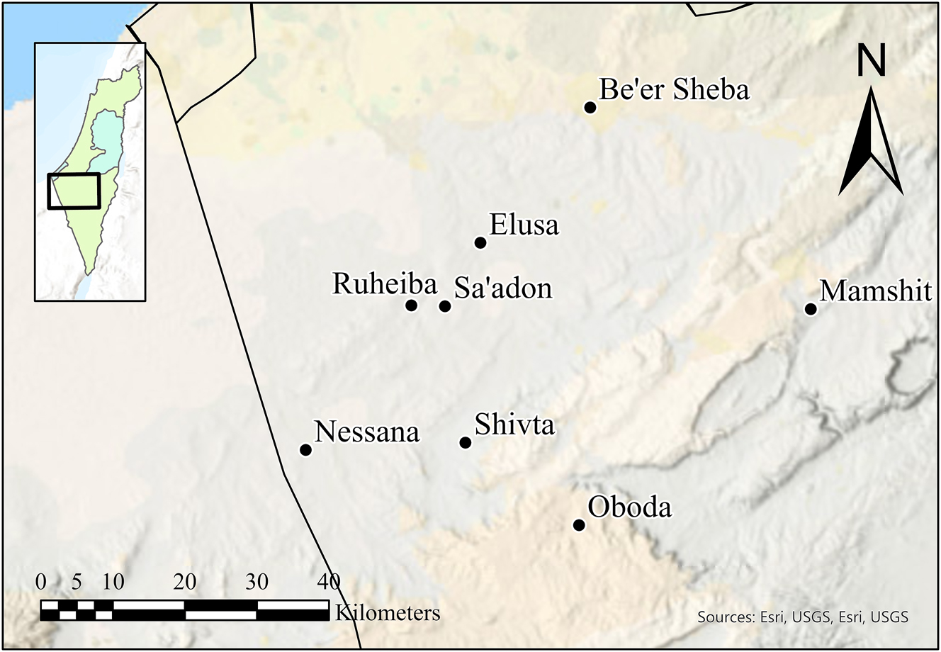
A map rendered in ArcGIS Pro v.3.1.3 showing the sites of the North-Western Negev desert which are commonly featured in the debate.
In the various discussions and debates on the topic of the south of Israel in Late Antiquity, one tool which has often been neglected is archaeological surveys. Surveys have commonly been used in the past to understand population dynamics and settlement patterns of a given region. It is vital to remember that the sole reliance on excavations of large sites to build a complete picture of the past is incorrect, as throughout the pre-modern periods, a majority of the population resided in the countryside (Cherry 2005, p. 249).
Accordingly, this paper aims to present and analyse the archaeological survey data of the territories south of latitude line 31.315, including the area of Beer Sheba, to time and examine the periods of demographic fluorescence and decline. Furthermore, this analysis also encompasses the Hellenistic and Early Roman periods to observe what transpired in earlier periods (Table 1). During the Early Roman period, another climatic change occurred, commonly known as the end of the “Roman Warm Period,” also ocasionally referred to as the “Roman Climate Optimum” (Erdkamp 2021; McCormick et al. 2012). This change was considered detrimental to the residents of the Mediterranean. As the current article wishes to show, an analysis of the changes in settlement numbers in the south of Israel will reveal that the main cause for the fluctuations in settlement numbers lies in anthropogenic causes. Thus, it implies that the term “Optimum” to describe the climate of the 1st century BCE to the middle of the 2nd century CE is incorrect due to the highly variable microclimates of the Roman Empire. For example, the Negev desert prospered from the end of this supposed climatic period. Lastly, the examination of the shifts in settlements would show that a downturn in the number of sites occurred in the 7th century and not in the 6th century CE, refuting the idea that the LALIA and the Justinianic plague played a part. The analysis conducted will show that this was a continuous process throughout the 7th and 8th centuries CE, with the Persian invasion and the Arab conquest playing a significant role.
The periods used in the article and their dates, alongside the terminology of different periods and their respective dates used in the survey maps of the Israeli archaeological survey.
| Date | Period used in the current article | Periods in Israeli archaeology | |
|---|---|---|---|
| 333–50 BCE | Hellenistic | 333–140 BCE | Hellenistic |
| 140–50 BCE | Hasmonean | ||
| 50 BCE – 325 CE | Early Roman | Pre 106 CE | Nabatean |
| 37 BCE – 70 CE | Herodian | ||
| 63 BCE – 325 CE | Roman | ||
| 325–636 CE | Late Roman | Byzantine | |
| 636-750/970/1099 CE | Early Islamica | Umayyad/Early Islamic/Islamic | |
-
aSee p.7 for further details on the dating of the finds under this category.
2 Environment and Landscape of the South of Israel
The main region in the south of Israel is the Negev desert, spreading out over 12,500 km2 of land (Singer 2007, p. 47). To its west is the Sinai desert, to its east is the hyper-arid Arava Rift Valley which is part of the Syrian-African Great Rift, and its southernmost point is the Gulf of Aqaba and the Red Sea (Rosen 2017, pp. 3–4, 6–7; Singer 2007, pp. 47, 50). This region can largely be divided into several geomorphological regions: the Eilat hills in the south, the highlands and plateaus in the central Negev, the Beer Sheva basin, the sandy Western Negev, and the Arava Rift Valley in the east (Singer 2007, p. 47).
The two most important regions to note are the highlands and the Arava. The highlands in the central Negev is composed of valleys and ridges running parallel in a northeast to southwest direction, morphing into sandy plains in the south (Singer 2007, pp. 48–50). This region is often split into the northern Negev Highlands, central Negev Highlands and the southern Negev Highlands (Rosen 2011, 2017). The Arava Rift Valley, sometimes known as its own separate desert, extends 165 km from the Dead Sea to the Gulf of Aqaba (Singer 2007, p. 52).
The climate in the Negev changes from region to region and fluctuates year-round. For example, the northern Negev has average winter temperatures of around 12 °C and average summer temperatures of 26 °C, while the southern Negev has an average of 12 °C in winter and 32 °C in summer (Bruins 2012, p. 29; Goldreich 2003). Rainfall is largely in winter, while there are droughts in summer, with the amount of rainfall declining in a north-south and eastwards gradient (Figure 2), with up to 300 mm of rain in the northern Negev in certin years, and as low as 25 mm of rain in the south in some others (Bruins 2012, p. 29; Rosen 2011, pp. 3–4, 2017, p. 7).
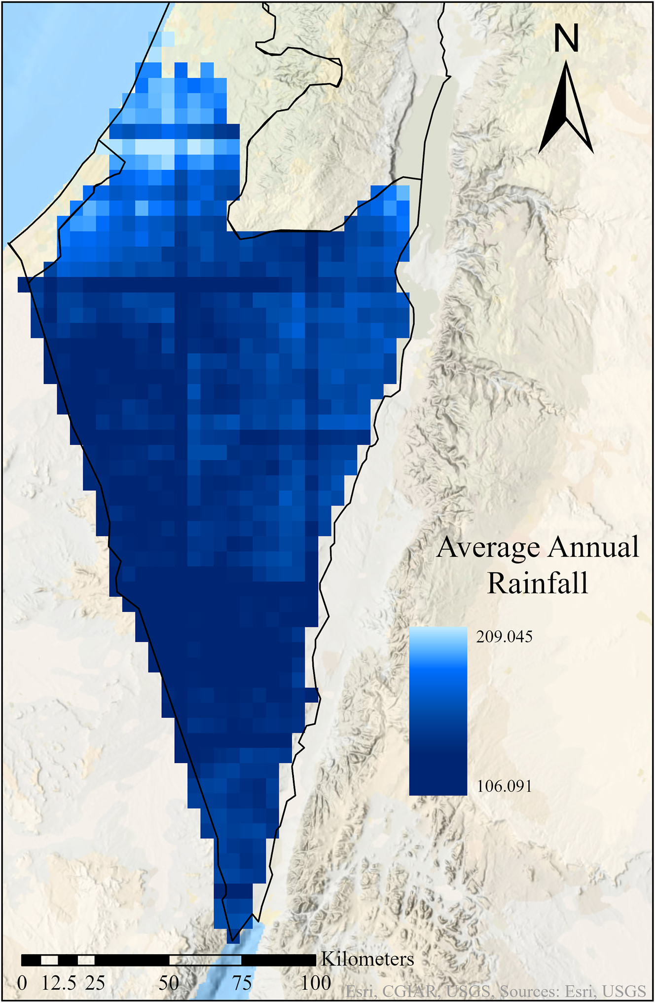
A map rendered in ArcGIS Pro v.3.1.3 showing the annual average rainfall in the South of Israel from 2003 to 2024.
3 Methodology and Limitations
A large part of the data used was taken from the Israel Archaeological Survey (see Supplementary Material),[1] which is the most thorough archaeological survey conducted in any country. The entire country was carefully divided into survey grids of 100 km2 (10 × 10 km) in the early 1960s, with each grid intended to be published as a survey map (Sion 2014), of which 70 % have been surveyed and published since the 1960s.[2] Each map was published after a team of archaeologists systematically surveyed the area on foot, and methodically inspected every square metre of the grid where possible. Individual teams plotted, marked, and noted any site with signs of anthropogenic activity, as well as dated the sites where possible using indicative sherds or other artefacts. Upon the completion of a survey, the team would include a summary and analysis of the various periods identified in the survey grid, as well as their conclusions concerning changes in settlement patterns, the date of these changes, and their possible causes. The subsequent sites, which are any place with evidence for any pre-modern human activity, were categorised by period and characteristics. Through this, one could understand the trends in settlement patterns throughout the different periods of history, and prehistory, in a given area (Sion 2014, pp. 58–59).
It is important to note the stark difference in the terminology used within the research conducted on the Eastern and Western Roman Empires (Elton 2018; Heather 2018, p. 6). This is especially true in archaeological publications and creates many complications in academic discourse. Levantine scholarship tends to use the term Byzantine to define the period between 284 CE (sometimes used in Egypt) or 325 CE (used in Israel, Lebanon and Syria) until 636 CE. Similarly, Late Roman is defined as the 2nd and the 3rd centuries CE, although in the archaeology of Egypt the terminology is currently changing and they define the Early Roman period as 1st to the 2nd century CE, the Middle Roman period as the 3rd to the 4th century CE, and the Late Roman period as 5th to the middle of the 7th century CE (Kenawi 2014; Wilson and Grigoropoulos 2009). On the other hand, the period from 325 to 636 CE is called the Late Roman period in western scholarship, similar to the terminology used in other countries, such as Turkey, which defines the 1st to the 3rd century CE as the Early Roman, and the 4th to the 7th century CE as the Late Roman (Blanton 2000, p. 60; Niewöhner 2011, p. 109; Rose 2011, p. 164). We agree with Elton (Elton 2018), and Heather (Heather 2018), regarding the lack of any significant change in the beginning of the 4th century CE in the east, which would deem the change in terminology from Roman to Byzantine as acceptable and logical. Only from 636 CE is there enough significant change in the Eastern Roman Empire to warrant a new definition for this entity, the Byzantine Empire. Furthermore, there is importance in common language when discussing the same period of time and entity, and there are several names for the same period in Israeli archaeology. Therefore, a unified terminology was utilised in this current article, and corresponds with the research in Egypt, Turkey, Cyprus, Greece and so on, as well as clarifying any duplicate terms in Israeli archaeology (see Table 1).
Published data from the website of the archaeological survey and its hardback publications was collated in an Excel spreadsheet and was systematically reviewed to correct any discrepancies between the tables, maps and individual site information.[3] As the website in English and Hebrew, as well as the existing printed publication, were not always identical, the maps, the information on the sites and the general description and analysis of the individual surveys were compared to garner the maximum information for each of the individual sites and to successfully calculate the correct number of sites from each period for each map. Sites dated from the Hellenistic to the Early Islamic (Table 1) were extracted from the survey (see Supplementary Material), and the resulting data were qualitatively and quantitatively analysed. In addition, any instances in which sites were labelled as two periods, such as Roman-Byzantine, were included in the counts for both Roman (Early Roman, see Table 1) and Byzantine (Late Roman, see Table 1) sites. This information was then compared with the available excavation data from the south of Israel, especially with the collated salvage excavations published by Faust and Safrai in 2015 (Faust and Safrai 2005, 2015). The salvage excavations were also counted, and in cases where there were numerous salvage excavations conducted at one site, all the excavations were counted only once and represent one site. The resulting trends were analysed in light of the historical context and the available archaeological evidence.
There are several known problems with archaeological surveys, several of which pertain to the archaeological survey of Israel itself. The quality of the results is dependent on several objective factors such as the area of the survey. In addition, the experience, expertise and fatigue of the surveyors, as well as the basic assumptions of the researchers, can also influence the quality and interpretation of the results (Cherry 2005, p. 250; Dagan 2014, pp. 5–6). For example, periods which are more familiar to the excavators will be better represented in surveys, than those that are less familiar.
Another drawback to using archaeological surveys, and especially the Israel Archaeological survey, to examine settlement patterns is the lack of quantitative data which is published. As these survey maps were intended for documenting and registering archaeological sites, the dating of the sites is provided by the surveyor with limited to no database to support the surveyor’s claims (Leibner 2009, p. 60), which can lead to various problems (Magness 2003). It is important to note that a selected assemblage of representative sherds of the different periods found at each site are collected during the survey and deposited at the IAA for future researchers.[4] Furthermore, the environmental conditions during the data collection can impact the survey results, such as weather, light or the seasons. For example, winter in Israel can obscure archaeological finds from the surveyors due to the significant increase in vegetation (Cherry 2005, p. 250), although this problem is less prevalent in the south of Israel. Moreover, in certain regions, it is difficult to differentiate certain sherds from the surrounding geology, and there is the common inability to subdivide periods with certain local pottery types.
A common argument regarding surveys is the extent to which the surface finds reflect the periods of settlement at a site (Leibner 2009, p. 60; Tartaron 2003, p. 24). This matter, as well as other issues, can be relatively settled with regards to the region of Israel, as a thorough re-examination of some of the survey squares in the Galilee was conducted via a new survey, some excavations and dozens of test pits and probes. Their results showed that the original survey finds stand the test of time and a more thorough examination, thus implying that the reliability of this data is high (Franḳel 2001). It is important to note that the survey finds for a single site may be inaccurate in a few cases, but the survey is accurate in detecting general changes and trends in large regions – the type of research and debate the current article wishes to conduct.
This is further supported by the salvage excavation reports showing a similar trend when compared to the survey of the entirety of modern-day Israel (Figures 3 and 4). However, the salvage excavations do not present as stark an increase in the Late Roman period compared to the survey, as the largest increase in site number was in the south of the country, while salvage excavations mainly represent the north and the centre of the country (Olshanetsky and Cosijns 2024). When comparing the salvage excavations and the surveys in northern and central modern-day Israel (Figure 5), the almost identical results are clear, highlighting the reliability of the survey to identify general trends. Therefore, survey results need to be viewed with caution and to be supplemented with other data such as excavations or direct dating methods (Dagan 2014, pp. 5–6), as the current article does.
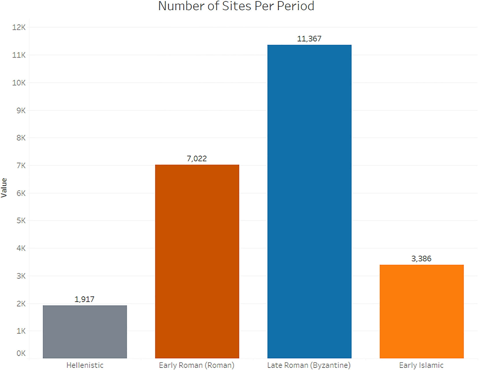
The number of sites found in archaeological surveys in Israel attributed to the Hellenistic, Early Roman, Late Roman and the Early Islamic.
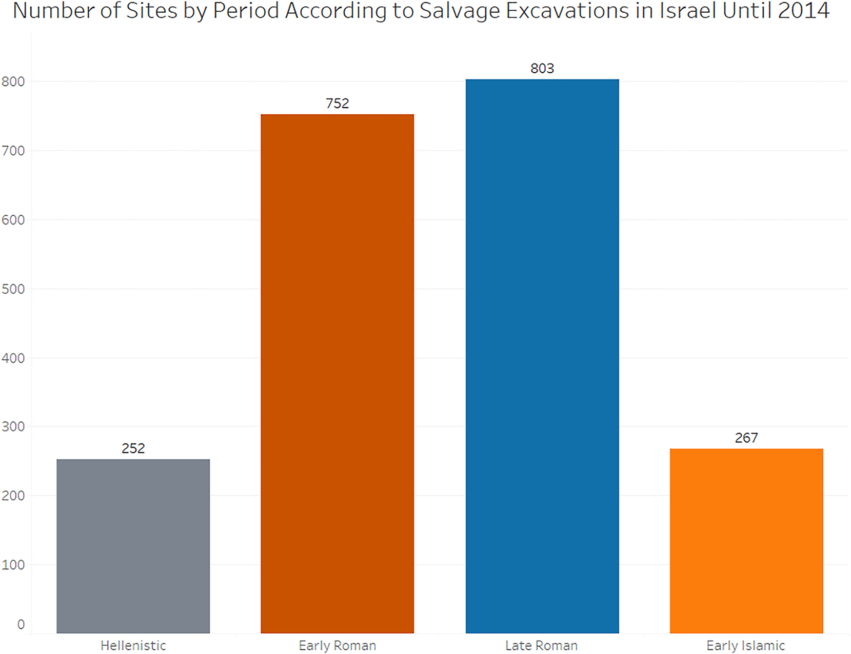
The number of sites excavated in salvage excavations dated until 2014 attributed to the different periods.
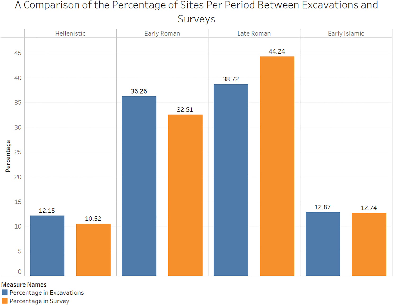
A comparison of the percentage of sites found per period between salvage excavations and archaeological surveys in the centre and North of modern-day Israel.
Regarding the Early Islamic, sites designated under this category do not represent all sites between 636 and 1099 CE. It was rather meant to represent the period 636 to 750 CE, i.e., the Umayyad period, as best as possible. However, not every survey managed to clearly identify all sites, and to split all sites into distinct categories. Therefore, all sites in categories that commenced in the year 636 CE were included, such as sites generally dated to the Islamic period. Nevertheless, where possible, sites which were dated after 750 CE were excluded. Henceforth, there may be some sites which are not precisely dated to the Early Islamic, i. e. 636–750 CE, and the value is slightly inflated.
Another factor which must be raised is the context of the Negev in the region. While the data from this article was collected within modern political borders, there was no such physical border during the time periods of this article. Therefore, the settlement trends visible in the south of Israel may well be perceptible in the Sinai Peninsula and central Jordan. Furthermore, geographic regions and archaeological sites do not exist in a vacuum, but are part of larger social, economic, and regional systems, and the more fragile and challenging a region is, the more they are influenced and impacted by their neighbours and other parts of their network. This is especially true for the south of Israel, a resource-limited environment that is inherently fragile to any drastic economic, environmental or geopolitical changes within its region and beyond. Consequently, it would be incorrect to discuss any observable changes in the archaeological record of the south of Israel without considering observable vicissitudes, or textual accounts, in and from the neighbouring regions and beyond. Therefore, the following analysis takes into account changes, or events, in the neighbouring regions or the wider Empire, which may have caused the changes in the number of sites observable in the south of Israel.
4 Results
According to the archaeological survey of Israel, the number of anthropogenic sites in the south of Israel was 118 during the Hellenistic period. This number increased in the Early Roman period to 1,399 sites, with a further increase to 3,775 sites in the Late Roman period. There was a decrease in the number of sites to 1,222 in the Early Islamic period (Figure 6).
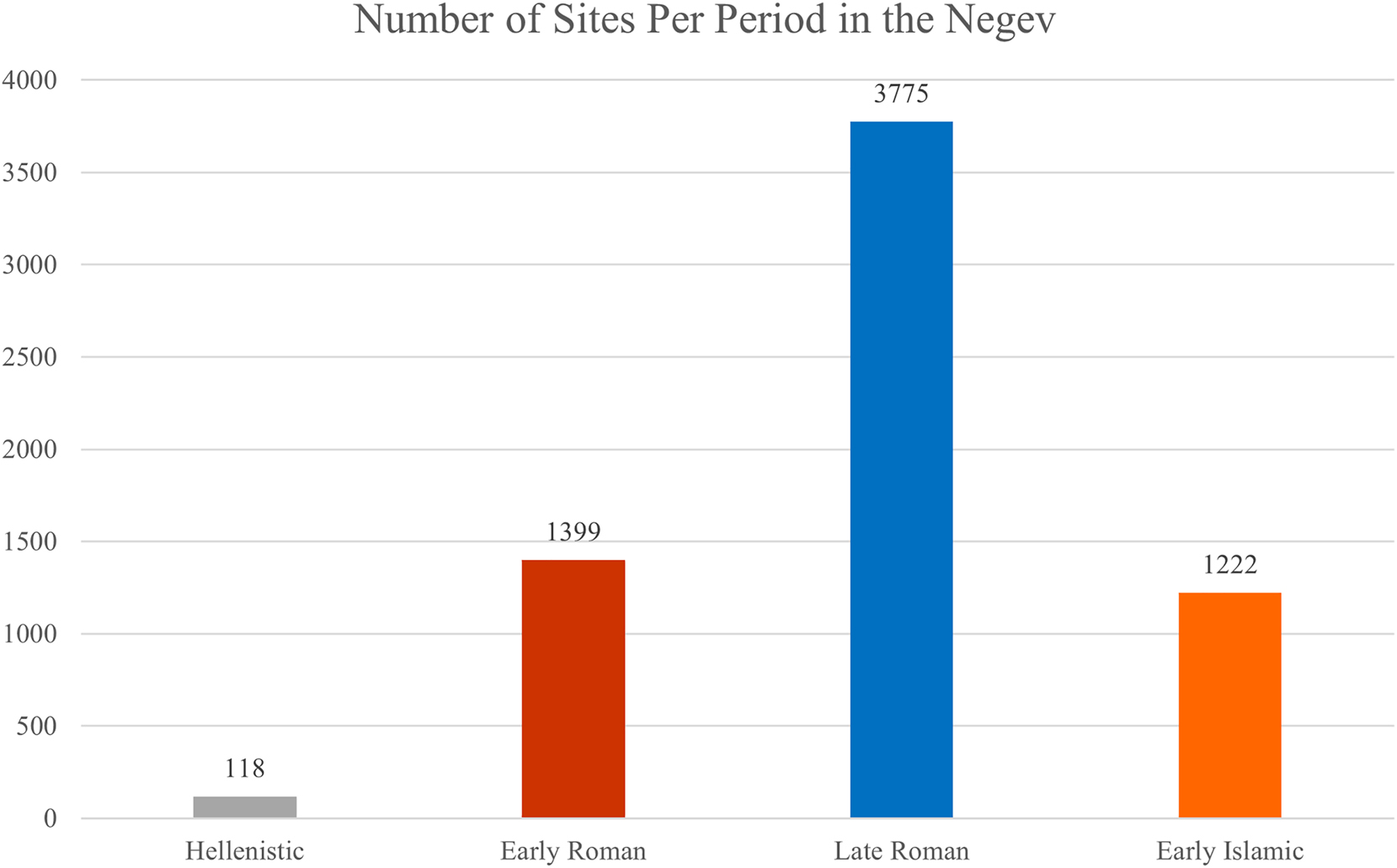
A graph showing the number of survey sites showing human activity in the South of Israel from the Hellenistic to the Early Islamic period.
4.1 The Increase in Settlements from the Hellenistic to the Early Roman Period
The transition from the Hellenistic to the Early Roman period saw some of the most dramatic changes in settlement density in the south of Israel, as can be seen in Figures 6 and 7. While the Hellenistic period had just 118 sites in several concentrations of settlements in the far northern part of the Negev and the south of the Arava, the Early Roman period saw a stark increase to 1,399 sites. This increase is visible in the north-west and north-east regions of the Negev, as well as in the Arava valley and the southernmost point of Israel, near the city of Eilat. This same increase is reflected in the salvage excavations conducted in the south of Israel, with eight sites dated to the Hellenistic period, and 33 dated to the Early Roman period, and in Michael’s analysis of the far northern Negev (Michael 2022, pp. 93, 96, 147, 150–151). The Hellenistic salvage excavation sites are largely in the Arava and the north of the Negev, with the former region composed of sites which are largely early Nabatean or Hasmonean fortresses, although it seems that their origins may even be attributed to the Early Hellenistic period (Patrich 2012). The Early Roman salvage excavation sites were spread out relatively equally (9 in the northern Negev, 2 in the west, 13 in the Central Negev and 9 in the Arava), with many of the Arava and Central Negev sites of Nabatean origin.
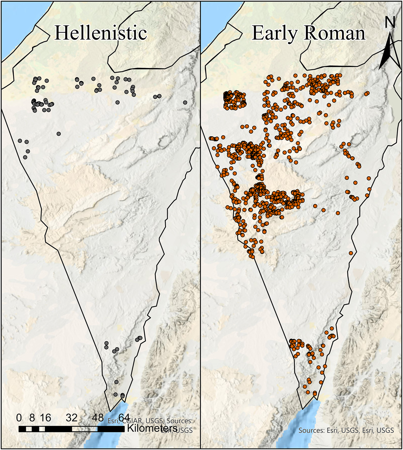
A map of the survey sites in the South of Israel dated to the Hellenistic (left) and Early Roman (right) period. The map was produced using Arc GIS Pro v.3.1.3.
It is important to note that this increase in the number of sites can be split into two phases, as many of the Early Roman period settlements, especially to the south of Be’er Sheva, are Nabatean (258 sites). They were primarily traders who set up way stations and trading outposts in the desert for the transport of goods from Arabia to Egypt. As such, a majority of the Nabatean sites in the south of Israel are both concentrated around earlier infrastructure and ephemeral in nature, rather than sedentary settlements which characterise the advent of the Negev’s Romanisation (Margulis and Rosen 2025). Archaeological evidence indicates that the south of Israel may have been under slight Nabatean influence, probably from the end of the 3rd century BCE, although there is no clear evidence for their presence in the region before 169 BCE (Erickson-Gini 2010, pp. 37–38; Margulis and Rosen 2025; Patrich 2012, p. 15). The transition from a pastoral to sedentary lifestyle happened in the 1st century CE, with the commencement of large-scale unguent processing at Petra (Erickson-Gini 2010, p. 43; Negev 1988, pp. 9–22). Numerous settlements were constructed and fortified throughout the Nabatean kingdom, including in northern Arabia, the Hauran and the Negev desert, the latter of which includes sites such as Horbat Bor, Mizpe Ramon, Shivta, Avdat and Rehovot-in-the-Negev (Abadi-Reiss 2020; Dahari and Sion 2017; Erickson-Gini 2010, pp. 43–45, 2015; Sion et al. 2022; Tepper et al. 2018a, pp. 143–145, 148; Tsafrir and Holum 1988, pp. 119–123). The Nabatean Kingdom was subsequently annexed in 106 CE by the Empire, where it became part of the province of Arabia (Erickson-Gini 2010, pp. 46–49; Kennedy 1997, p. 72; Rubin 1996, p. 49; Tsafrir 1986, pp. 77–78).
This highlights a problem with using archaeological survey data. The terms and periods that are often used are at times artificial, and historical events and changes are sometimes within the periods themselves rather than between periods. For example, each change occurred in different times, especially with regards to the transfer to direct Roman rule. The establishment of Roman rule in Judaea started in the middle of the 1st century BCE (Cameron 2018), or the beginning of the 1st century CE (Schwartz 1990; Zeichmann 2015, pp. 182–180, 189–188). However, it happened in earnest only from the beginning of the 2nd century CE in the Negev.
The annexation of areas under Roman rule brought an increase in settlement number, as can be seen in the archaeological record. Out of the 1,399 Early Roman sites, only 18.4 % of them (258 sites) have Nabatean pottery, suggesting that the main increase in the number of settlements occurred after 106 CE. The year 106 CE holds significance despite suggestions that Nabatean pottery may have continued to be produced after the annexation of the Nabatean Kingdom (Erickson-Gini 2021), as the presence of Nabatean pottery at various sites primarily reflects settlements that existed prior to 106 CE. In contrast, other sites, constructed by the Romans, are likely to date to post-106 CE. This increase can be explained by the continued development of run-off irrigation (Bruins 2012, p. 37), as well as the relative peace under Roman unified rule leading to an increase in building projects in the area (Erickson-Gini 2010, p. 50). This is especially true for the central Negev desert and the Arava, as these regions remained peaceful even in times of turmoil and war in the northern province of Judaea. On the other hand, the northernmost part of the Negev was impacted by the turmoil in the north, and numerous settlements to the north of Be’er Sheva were abandoned in the 2nd century CE (Heinzelmann et al. 2022, pp. 97–100, 151–154). A post-106 CE date for the increased number of settlements complements the fact that the rest of Judaea stabilised after the end of the Second Jewish Revolt in 136 CE (Olshanetsky 2024). It is interesting to note that an increase in the number of sites occurred when the rest of Judaea/Palaestine suffered major military turmoil and temporary depopulation. Therefore, the possibility that Jews may have immigrated from the north to the south due to war should be considered and must be further explored in the future. Furthermore, the stability in the Negev was brought to the area by the large amounts of imperial funds which were invested in the different regions in the form of roads, buildings, temples and facilities (Negev 1988). This can be seen in the establishment of the road linking Petra and Gaza, on which 23 milestones dated to the 2nd century CE were found (David and Isaac 2020), the investment and expansion of former Nabatean settlements (Abadi-Reiss 2020; Dahari and Sion 2017; Erickson-Gini 2010, p. 50, 2015; Sion et al. 2022; Tepper et al. 2018a, pp. 143–145, 148; Tsafrir and Holum 1988, pp. 119–123), as well as the establishment of new sites and agricultural installations in the south of Israel (Erickson-Gini and Bekes 2019; Junge et al. 2021; Tepper et al. 2020).
Thus, the area prospered due to imperial investments (Rubin 1998). As the new areas were annexed by the Empire, no custom duties were imposed on products from these areas, increasing the accessibility, affordability, and profits from the goods. The increase in wealth drove the Roman Empire to further invest money to improve accessibility and security in the area through the protection of roads and erecting forts (Beit-Arieh and Cresson 1991; Tsafrir 1986, pp. 83–85), to prevent raids from nomadic tribes (Mayerson 1989; Parker 1986). Crucially, the second phase of increase, which commenced in 106 CE, contradicts the definition of the Roman Climate Warm Period (a warmer climate which lasted from the 1st century BCE until the beginning of the 2nd century CE) as a period of optimal climate (or a Roman climate optimum) (Erdkamp 2019, p. 429). This is because, as is clear from the data, there was a different optimal climatic period for each region or sub-region, which often differed from other regions due to a regional microclimate (Izdebski et al. 2016). There is no century which was necessarily climatically optimal for the entire Mediterranean basin, and often the available climate proxies for a region contradict the fluctuations in settlement number and population which are visible in the archaeological record. As Kouki defines in her paper, it questions the reliability of climate proxies, even for regions adjacent to the sites where climate proxy data was collected (Kouki 2013, pp. 206–211).
4.2 The Increase Between the Early Roman and Late Roman Periods
The increase in the number of settlements continued and peaked in the Late Roman period with 3,775 sites (Figures 6 and 8). While 62.7 % of Early Roman sites were also occupied in the Late Roman period, settlement activity in the region intensified, except for the Arava, where the number of sites decreased. Although, the overall number of sites in the Arava is only slightly less (31) than in the Early Roman period (33). On the other hand, the north-western Negev is an area largely devoid of any salvage excavations, with extensive archaeological excavations mostly conducted at the sites of Shivta, Elusa, Nessana, and Rehovot-in-the-Negev in the north-western Negev, demonstrating the expansion and intensification of the settlements during the Late Roman period (Dahari and Sion 2017; Heinzelmann et al. 2022; Tchekhanovets et al. 2023; Tepper and Bar-Oz 2020; Tepper et al. 2018a; Tsafrir and Holum 1988; Urman 2007). Other than this region, salvage excavations in the northern Negev highlight a drastic increase in the number of sites to 16 in the Late Roman compared to 9 in the Early Roman, as highlighted in Noe’s analysis of the surveys and excavations from the Late Roman period in the most northern parts of the Negev (Michael 2022, pp. 108–109, 158). Furthermore, several important sites were developed in the western Negev, with an increase from only 2 sites in the Early Roman period to 4. On the other hand, the number of sites from salvage excavations in the Arava decreased from 9 sites in the Early Roman to 2 sites in the Late Roman period.
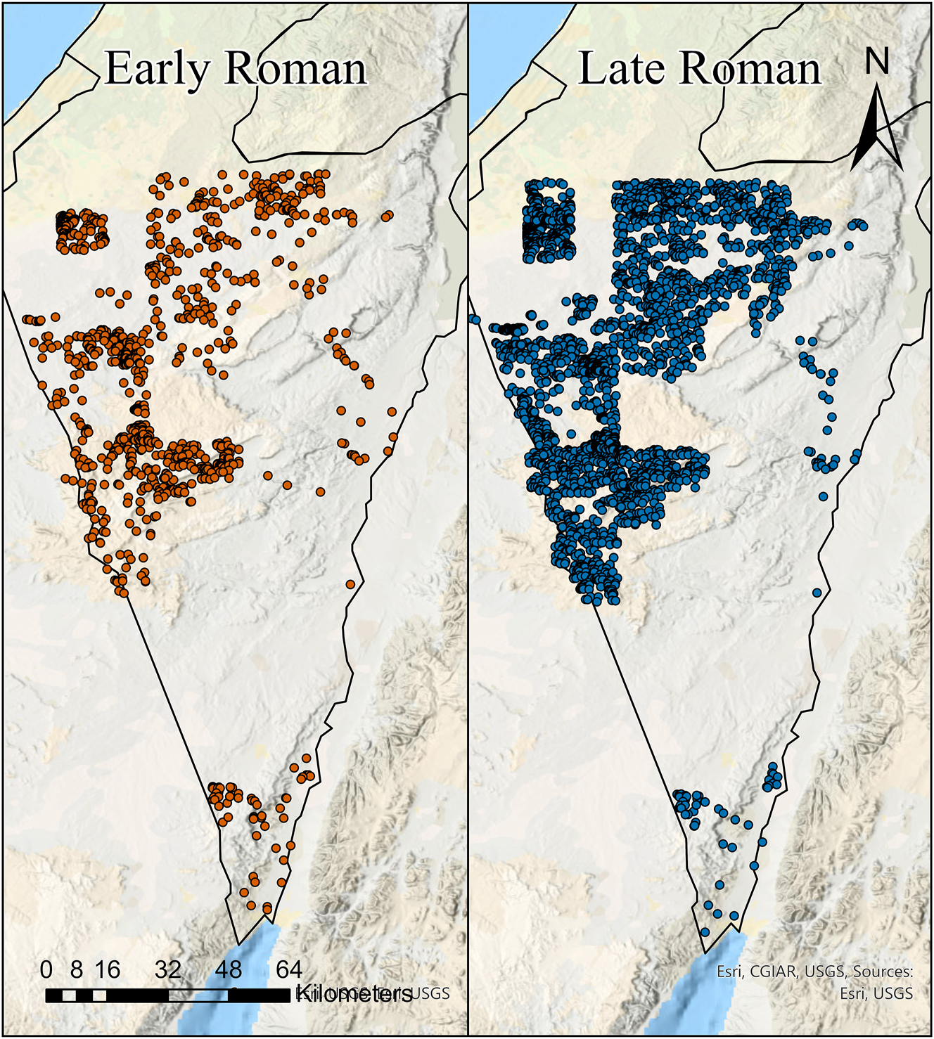
A map of the survey sites in the South of Israel dated to the Early Roman (left) and Late Roman (right) period. The map was produced using Arc GIS Pro v.3.1.3.
This peak in the number of sites can be explained by the rapid development of run-off farming, which expanded agriculture in the Negev desert, and the transition between sedentary and nomadic lifestyles 100 km further south (Rosen 2011, p. 10). In addition, the relative peace in the area, with no major conflicts in the region, contributed to this expansion (Avi-Yonah 1956; 1980, pp. 158–153; Nathanson 1986). The increase in population is attested in other parts of the Empire, such as in North Africa (De Vos Raaijmakers and Attoui 2013; De Vos Raaijmakers et al. 2013; Hirschfeld 1997; Rubin 1998), and modern-day Turkey, for example the Maeander Valley (Thonemann 2011, pp. 55, 259), Phrygia (Niewöhner 2013, p. 223), West Cilicia (Blanton 2000, p. 60), Miletus (Niewöhner 2011, p. 109), Troad (Cook 1973, pp. 369–374),[5] and its surroundings (Rose 2011, p. 164). This may have been exacerbated due to large migration waves from the Western Roman Empire, refugees who either decided to flee east in its last century of decline, or escape after it dissolved when its last Emperor, Romulus Augustulus, was deposed in 476 CE (Ferrill 1986; Murdoch 2006), as many may have wished to remain under Roman rule.
Nevertheless, the demographic and settlement fluorescence which occurred in Palaestina was more significant. Therefore, there is a large question as to why people decided to settle in the desert. What were the pull factors which contributed to this increase in population and the number of settlements? One of the major pull factors, other than peace, prosperity, stability and imperial investment, may have been religious, as it was closer to the birthplace of the Christian faith.
When Christianity became a legal and recognised religion in the early 4th century CE, Christians were a minority (Cosijns 2024, p. 34). By the 5th century CE, the urban areas of Palaestina Tertia underwent intense Christianisation, and Christianity became one of the dominant religions in the area (Bar 2003). However, imperial investment in the region, some of which may have derived from the Christianisation of the Roman Emperors, already began from the reign of Constantine (Avi-Yonah 1958, pp. 541–543). Some of these investments were just standard investments, similar to what can be seen in other regions such as North Africa, which was conquered by Justinian in 534 CE (Rubin 1998). The prosperity in the land and the abundance of resources encouraged an increase in population, which in turn drove an increase in production and wealth. The situation drove the Empire, as well as the church, to further invest in the land. This investment can be seen by the enormous amount of churches and monasteries built throughout the Empire, but especially in Palaestina (Avi-Yonah 1958; Bar 2003, pp. 403, 406–407; Patrich 2019; Patrich et al. 2020). The increase in the number of ecclesiastical establishments played a few major roles: to show the dominance of Christianity, to facilitate and enable Christians to observe their faith, and, more importantly, to try and convert large parts of the population to the Christian faith. The construction of ecclesiastical buildings brought prosperity, wealth and pilgrims, which in turn brought more wealth, investment and people to the area.
This is especially evident in the Negev desert. The intensive habitation of the Negev desert was enabled through imperial investment, with the construction of numerous agricultural terraces during the Late Roman period (Avni et al. 2013; Bruins 2012). These terraces intended to harvest the flood waters which were in turn used to turn large swathes of uninhabited and uncultivated land into fertile agricultural land (Rosen 2017, p. 18). This brought people to settle in the area, who may have been predominantly Christian due to the area being tied to the Christian faith,[6] alongside a concerted effort by the authorities to convert the desert tribes to Christianity as they became the primary defenders of the borders of the Empire (Rubin 1996, p. 55). The growing Christian population in the region encouraged the construction of ecclesiastical establishments such as churches and monasteries, with roughly 30 churches and 15 monasteries constructed in the Negev desert by the end of the 6th century CE (Wacławik 2017, p. 108). The Church and its numerous facilities became the most prominent institution in the Negev, managing the administrative affairs in the settlements (Mayerson 1982, pp. 51–52), and closely interacting with the community to the point where the leaders of Nessana were designated as “a priest and an abbot” (Rubin 1996, pp. 55–56). This in turn brought more people to the area, including pilgrims, some of whom were drawn to the desert to witness the desert monastic and eremitic way of life, such as Antonius of Piacenza (the Piacenza Pilgrim) who made a detour in order to visit a convent near the Dead Sea (Mayerson 1982, p. 52). The pilgrims were an important source of manpower for the monasteries (Seligman 2020, p. 32; Whiting 2020, p. 75), who stimulated the creation of new ecclesiastical establishments, such as monasteries and xenodochia (Christian hostels) (Voltaggio 2011; Whiting 2020, p. 76).
The pilgrims also travelled to the Negev because it was one of, if not the main, gateway to the Sinai Peninsula and Mount Sinai. The route is partially described by Antonius of Piacenza, who travelled from Elusa into the Sinai desert (Piacenza Pilgrim, Itinerary, 34). Although there was a different route through Egypt, as described by the nun Egeria (Egeria, Itinerary), it seems that, despite popular conjecture (Negev 1977, p. 79), the route through the Negev desert was also commonly used. Throughout the Sinai peninsula, there are around 8,500 inscriptions, rock drawings and graffiti in Nabatean, Greek, Latin, Coptic, Armenian, Hebrew, Aramaic and Arabic (Stone 2015). One of the largest concentrations of graffiti is in Wadi Haggag, a valley in the southeast of the Sinai Peninsula with over 400 inscriptions, a majority of which have a Christian nature. Some of these inscriptions date to the early 4th century CE, while a majority of them date from the 5th century CE and later (Negev 1977, pp. 3, 76–77). The route through Wadi Haggag would have been frequented by pilgrims travelling through the Negev desert (Mayerson 1982), and so this suggests that the Negev settlements may have greatly benefited from the pilgrim traffic in Judaea/Palaestina, which in turn would have attracted people to the area.
4.3 A Decline in the Number of Sites
There was a significant decrease in the number of sites between the Late Roman, with 3,775 sites, to the Early Islamic which had 1,222 sites (Figures 6 and 9). From the Early Islamic sites, 76.6 % of them (966 sites) had an earlier Late Roman phase. The decrease was seen almost entirely throughout the south of modern Israel, except for two points. The first, the Arava, saw an increase in the number of sites found in the archaeological survey. This fact is also reflected in the salvage excavations, where the number of sites increased from 2 in the Late Roman period to 5 in the Early Islamic. The second, in the west of the Negev, is due to a decision by the surveyors to define all Late Roman (Byzantine) sites as also Early Islamic, although this decision was not supported with sufficient evidence as they stated that they believed the Late Roman ceramic typology continued a few decades into the Early Islamic. Thus, there is no sufficient evidence to conclude these sites continued throughout the entirety of the Early Islamic period.
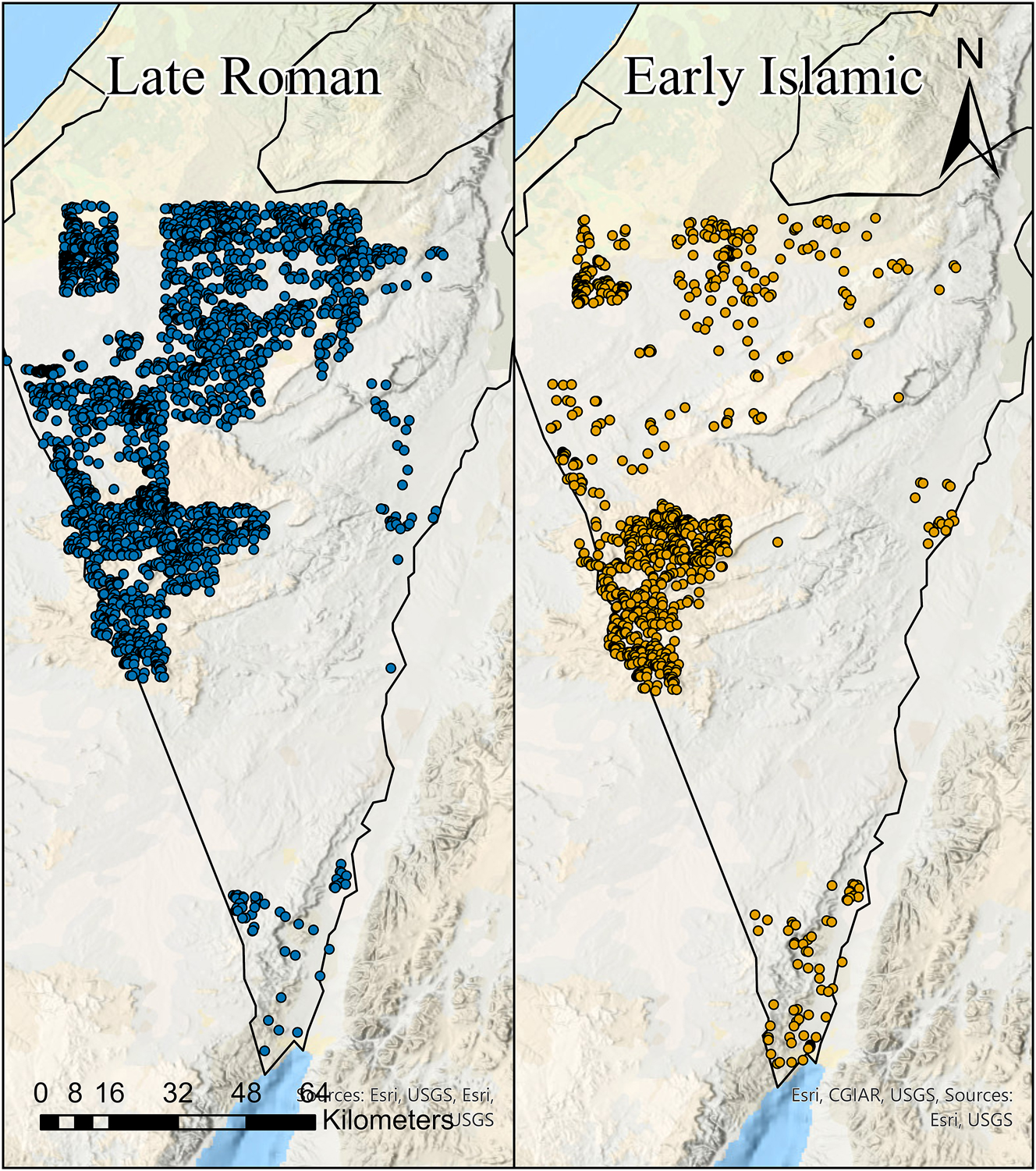
A map of the survey sites in the South of Israel dated to the Late Roman (left) and Early Islamic (right) period. The map was produced using Arc GIS Pro v.3.1.3.
The decrease in the number of settlements in the Negev desert specifically has come under scrutiny in recent years. Some researchers have tried to attribute this decline to the middle of the 6th century, and so claim that the LALIA or the Justinianic plague caused a decline in the size and number of settlements (Bar-Oz et al. 2019; Fuks et al. 2020; Langgut et al. 2020; Lantos et al. 2020). Before discussing their methodology, conclusions and reliability, a few words on the LALIA and the Justinianic plague and the state of the research on these phenomena are in order.
4.4 The Justinianic Plague and the LALIA
Two main cataclysmic events have lately been proposed to explain the reported decline in population and settlement numbers across the Eastern Roman Empire, not just in the southern region of Israel, alongside the continued debate whether this decline began in the 6th or the 7th century CE. The first is the Justinianic plague, which initially affected the Roman Empire, especially Constantinople, between 541 and 544 CE (Eisenberg and Mordechai 2019, pp. 25546, 25548; McCormick 2015, p. 345, 2016, p. 1005; Mordechai and Eisenberg 2019; Mordechai et al. 2019; Sarris 2002, pp. 174–175). It is believed to have spread across the Empire, with supposed outbreaks over the subsequent two hundred years (Sarris 2002, 2020). However, recent scholarship challenges the idea that the Justinianic plague was as devastating as previously thought (Harper 2017; McCormick 2021; Sarris 2020). These studies argue there is no concrete evidence that the plague decimated the Empire, that the numerous episodes linked to it over two centuries were catastrophic, or that they all stemmed from the same outbreak (Eisenberg and Mordechai 2019; Mordechai and Eisenberg 2019; Mordechai et al. 2019; Olshanetsky and Cosijns 2024).
There is some debate about the origins of the Justinianic plague and the exact timing of its first appearance. Phylogenetic evidence indicates that the earliest strain was found at Edix Hill near Cambridge, UK, with the sampled individual radiocarbon dated to 474–637 CE at 95.4 % probability. However, archaeological dating of this burial predates 550 CE (Keller et al. 2019, p. SI Table. S13). Since this is the earliest known Y. pestis (bubonic plague, linked to the Justinianic pandemic) strain from that period, Sarris argues that the burial should be dated to the late 5th or early 6th century CE (Sarris 2022, pp. 342–343). This suggests the Justinianic plague began before Justinian’s reign and may have arrived in the empire from a different source, challenging previous assumptions and contemporary accounts (Benovitz 2014, p. 488; Keller et al. 2019, pp. SI 18–23; Mordechai et al. 2019, p. 25547).
The closest ancestor of the Y. pestis strain linked to the Justinianic plague originates from the Tian Shan mountains in Central Asia and dates back to the 2nd century CE. Some experts suggest Central Asia as the possible location where the divergence event that led to the Justinianic plague occurred. Combined with the potential earlier date for the plague’s appearance in Europe, this supports the theory that the migration of the Huns to Europe introduced the ancestors of the Justinianic plague there (De Barros Damgaard et al. 2018, pp. 372–373; Keller et al. 2019, p. 12368). The discovery of the plague victim from Edix Hill suggests an earlier onset for the plague that affected the Mediterranean and raises questions about its infection rate, indicating that it may have circulated for centuries without causing noticeable outbreaks (Olshanetsky and Cosijns 2024). Moreover, there is no evidence of population decline in the 5th or early 6th centuries CE due to disease, especially in the eastern Mediterranean. The absence of such epidemiological records during this period is striking, considering the disease was likely widespread in the region. Furthermore, as of now, no mass graves, nor the Y. pestis bacteria in Late Roman remains, have been located in the Negev desert or the entirety of modern-day Israel and the West Bank, although several individuals infected with Y. pestis have been found in Jerash, modern-day Jordan (Adapa et al. 2025). According to the authors, the remains date to somewhere between 560 and 660 CE. However, as these remains were laid on top of the layer with late 6th to early 7th century pottery and before the 659 CE earthquake (Adapa et al. 2025, pp. 3–4), it is more likely they date to 620 to 650 CE. Yet, there is evidence for a change in climate for the period in question.
According to paleoclimatic research, the middle of the 6th century CE saw a period of global cooling caused by volcanic eruptions (Büntgen et al. 2016, pp. 231, 233; Peregrine 2020; Sigl et al. 2015; Toohey et al. 2016), which decreased the annual average temperature (Helama et al. 2017). These eruptions may have lowered the global average temperatures by up to 1.6 °C (Sigl et al. 2015), and 1.43 °C in the northern hemisphere (Stoffel et al. 2015, pp. 784–785). Yet, the decrease in temperatures was different in various areas. While the higher latitudes of the Northern Hemisphere faced a decrease of more than 2 °C (Sigl et al. 2015), the lower latitudes, which consisted of all the territories of the Late Roman Empire, may have experienced a decrease in temperatures as little as 0.25–1 °C. The southernmost areas of the Roman Empire, including Egypt and Israel, had a decrease of around 0.25 °C (Peregrine 2020). Some claim that the impact of this climate change was significant and lasted over a hundred years, from 536 to 660 CE (Büntgen et al. 2016; Fuks et al. 2017). However, there is a substantial debate about the extent and impact of this event, with some suggesting that it only lasted from 536 to 560 CE (Peregrine 2020). Furthermore, the presence of regional microclimates highlights that each region can and will experience climatic events differently.
This point is particularly emphasised in Arjava’s research, where he demonstrates the absence of textual evidence supporting the idea that the dust cloud of 536 CE, which allegedly obscured the sun and initiated the Late Antique Little Ice Age (LALIA), had any impact beyond Europe. In fact, ancient sources explicitly indicate that the dust cloud’s effects were almost entirely confined to Europe (Arjava 2005, pp. 80–81). Arjava suggests that the consequences of the 536 CE volcanic eruptions were likely limited to regions north of latitude 35, implying that much of the Eastern Roman Empire, including Judaea/Palaestina and Egypt, remained unaffected (Arjava 2005, pp. 82–83). According to his findings, Asia Minor (modern-day Turkey) is the only region within the Eastern Roman Empire where textual evidence points to any influence from the dust cloud (Arjava 2005, pp. 83, 93). Furthermore, literary, papyrological, and epigraphic sources do not report any long-term consequences. The few ancient writers who directly address the event note that its effects lasted no more than one or two years, and none mention any continued impact on agricultural production (Arjava 2005, pp. 83–94).
4.5 The LALIA and the South of Israel
While paleoclimate data from the Soreq cave speleothems and some Dead Sea sediment cores indicate low levels of precipitation (Bar-Oz et al. 2019; Fuks et al. 2020; Langgut et al. 2020; McCormick et al. 2012; Orland et al. 2009), other sediment cores from the Dead Sea (particularly from Ein Feshkah) and Levantine marine cores reveal higher precipitation levels, peaking in the 6th and 7th centuries CE (Izdebski et al. 2016; Migowski et al. 2006). The sudden peak in Dead Sea levels from Ein Feshkah could be linked to a brief period of increased rainfall. Therefore, the Soreq cave speleothems might be inconsistent with a cooling event, since a temperature decrease of 1–1.5 °C in Israel can sometimes lead to more rainfall in certain southern areas or improve habitability. Despite a slight increase in precipitation, the Negev desert’s climate would remain marginally altered, still classed as arid (Bruins 2012). However, if the cooling was accompanied by reduced rainfall, the long-term soil water retention, achievable due to robust and extensive Roman-era agricultural systems (Ashkenazi et al. 2020), and reduced evaporation caused by lower temperatures, would still support ongoing agriculture in southern Israel during the LALIA. The former factor, the development of well-established agricultural practices in the south of Israel, could have been robust enough to mitigate climatic events. For instance, even though the agricultural terraces of the south have not been systematically maintained in the last 1400 years, the Bedouin tribes living in the region still use this infrastructure to grow their fruit trees in the inhospitable desert even today (Ashkenazi et al. 2020). Thus, while the south of Israel is a marginal environment with a complex socio-ecological system, the small climatic shift of the LALIA may have been alleviated due to the agricultural infrastructure and practices of the Late Romans. Additionally, stable isotope analysis of archaeological sheep and goat remains from the Late Roman and Early Islamic periods suggests that grazing patterns and management strategies continued consistently, indicating that the Negev’s microclimate did not experience significant change (Vaiglova et al. 2020).
Another theory to explain the decline of this region, which was intertwined with the Justinianic plague and LALIA, is the over-exploitation of the land and its resources. This claim rests on the assumption that if the inhabitants are using wooden architectural elements from abandoned houses as fuel, this can be seen as evidence of the lack of natural fuel resources in the area, which an over-exploitation of the land can explain (Langgut et al. 2020, pp. 10, 15). This was further supported by palynological evidence. However, this theory does not align with the papyrological evidence from Nessana, and the dating of the palynological evidence is not based on radiocarbon dating and is arbitrary (Cosijns and Olshanetsky 2022).
In discussing climate proxies, it is important to highlight a point made by Kouki in her 2013 article. She notes that climate proxies can sometimes contradict one another, and when compared with neighbouring regions, even those as close as Jordan, they may conflict with the archaeological record. For instance, some proxies suggest reduced rainfall during periods of population growth, and increased rainfall during times of contraction. According to Kouki, such inconsistencies cast doubt on the reliability of climate proxies and the ability to interpret them accurately. This, she argues, underscores the growing need to place greater emphasis on the tangible, anthropogenic evidence found in the archaeological record (Kouki 2013).
4.6 Is the Decline in the Late Roman Period?
According to an extensive analysis and re-examination of the radiocarbon and OSL dating, stable isotope analysis and ceramic typology of the south of Israel, a decline did not occur in the middle of the 6th century CE. Some of the settlements at the heart of this matter are the large north-western Negev settlements of Elusa, Nessana and Shivta (Figure 1). The dating from the recent excavations of these sites was based on the ceramic typology of Gaza jars, commonly known as the Late Roman Amphora 4 (LR 4 or LRA 4) (Reynolds 2005, pp. 574–575; Riley 1975, pp. 27–31; Tomber 1996). The archaeologists largely utilised Majcherek’s typology when dating the sites (Bar-Oz et al. 2019; Fuks et al. 2020; Langgut et al. 2020; Majcherek 1995). This vessel is commonly thought to have transported wine, specifically Gazan wine (Mayerson 1992). A large quantity of the vessels found were Gaza jar type 3, whose production is dated to the latter half of the 5th century CE until 600 CE and was still in extensive use during the beginning of the 7th century CE (Cosijns and Olshanetsky 2022, pp. 21–23; Majcherek 1995, pp. 168–169), which suggests that the settlements were in use after the middle of the 6th century CE (Cosijns and Olshanetsky 2022; Olshanetsky and Cosijns 2023).
This conclusion aligns with the results of a study of Elusa, headed by a team from the University of Cologne. In their preliminary analyses, they remarked that ‘clear signs of transformation processes’ can be seen only in the 7th century CE (Schöne et al. 2019, p. 149). However, a more recent publication proposed that the decline in Elusa occurred in the 6th and 7th centuries CE (Heinzelmann et al. 2022). This apparent contradiction of their initial assessment may lie in their use of a dating methodology which misinterpreted the dating of Majcherek Type 3 jar, dating it from the middle of the 5th until the middle of the 6th century CE (Heinzelmann et al. 2022, p. 274) Yet, despite this, their raw data highlights how none of the sondages excavated by the team was abandoned before the end of the Late Byzantine period (Heinzelmann et al. 2022, pp. 253, Fig. 216).
It is important to note that this is a common error in the excavation results of the NEGEVBYZ project and its adjacent members, having both misinterpreted Majcherek’s 1995 typology and not employing updated typologies from the last two decades (Bar-Oz et al. 2019, pp. 8242–8243; Fuks et al. 2020, pp. SI Methods, Table 1). The updated Gaza jar/LRA 4 typology utilises data from excavations after 1993. However, Israeli archaeologists still tend to heavily rely on Majcherek’s earlier typology of Gaza jars (Sazanov 2017, p. 631), despite this only being preliminary work (Majcherek 1995, p. 169). In 2005, Dominique Pieri built on Majcherek’s typology from 1995 and reinterpreted Majcherek’s Type 3 as LRA 4B2, redating it from the second half of the 6th century to the 7th century CE (Pieri 2005, pp. 104, 106). Pieri’s recent publications also stated that the LR4 B was found in late 6th to first third of the 7th century Merovingian deposits in Marseille and the nearby region (Bonifay et al. 1998, pp. 125–127, 401; Bonifay and Pieri 1995, p. 112, 2020, p. 871). Thus, a correct reading of Majcherek’s typology, alongside the new typologies, emphasises that the dating needs to be amended and any claimed 6th-century CE decline should be dated to the 7th century CE.
This conclusion is supported by the changes in the ceramic assemblages of the Negev. From late 6th century or early 7th century CE, there is a general increase in the number of sherds found at the sites in the northwestern Negev, and especially an increase in the later type bag-shaped jar sherds, commonly known as Late Roman Amphora 5 (LR 5 or LRA 5) (Reynolds 2005, p. 573). Both bag-shaped jars (Kingsley 2004, p. 118; Mango 2001, pp. 49–50; Pieri 2005, pp. 114–125; Reynolds 1995, pp. 71–72), and Gaza jars (Mango 2001, pp. 50–51), were used to transport commodities, although bag-shaped jars were also used for storage (Meyers 1981, pp. 61–71). This increase in the number of sherds and the change in the ratio of bag-shaped to Gaza jar could have been caused by two possible scenarios (Olshanetsky and Cosijns 2021, pp. 15–16, 2022, pp. 38–40).
The first is that disruptions of the trade routes due to the Persian Invasion of 614 CE may have caused the farmers in the Negev to produce more local bag-shaped jars (Erickson-Gini and Mamalya 2022, pp. 155–157; Heinzelmann et al. 2022, p. 273), because of their dual usage for storage and trade, and as compensation for the decrease in the imports of the Gaza jars to the region. The situation only worsened with the Arab Conquest of 636 CE, prompting some farmers to concentrate on cultivating cereals, due to easier storage solutions. Another possibility is that Gaza jars became scarcer in the Negev once the wars reached the region, as they were initially transported already filled from the coastal areas. As the ability of Negev settlements to import goods declined, fewer vessels were imported to the region, reducing opportunities to repurpose them for export or domestic use. Consequently, local villages in the Negev responded by increasing the production of bag-shaped jars (Olshanetsky and Cosijns 2021, 2023, 2024).
Regarding the second scenario, the archaeological evidence suggests the region grew considerably wealthier throughout the 6th century CE. Due to this increase in prosperity, there may have been an increase in the imports packaged in bag-shaped jars, as they were used to import a variety of products. A good way to examine both theories is to analyse the fabric and petrology of the sherds found in the sites (Holmqvist 2009, 2019, pp. 118–119), as the pottery made in the desert settlements had a distinct, pale yellow colour (Holmqvist 2019, p. 55). This is true for both Gaza and bag-shaped jars (Erickson-Gini et al. 2018), with some naming the Negev produced Gaza jar, the Elusa jar (Fabian and Goren 2002).[7] It is also important to emphasise that the LRA 4 did not always contain wine (Caputo 2019, p. 187; Passi et al. 1981, pp. 783–784; Pecci et al. 2010, p. 367; Romanus et al. 2009, pp. 901, 903). This factor, alongside the distinct fabric of the LRA 4, which identifies them as being produced in the coastal region, damages the theory that the northwestern Negev was part of Gazan wine production.
This is further supported by the radiocarbon and OSL dates. Although there are few radiocarbon dates for the Negev for the Late Roman period, some of them show that some structures, such as pigeon towers, were used until the beginning of the 7th century CE. These towers were used to date the decline as the pigeons of the Negev were grown for their faeces, which was used as fertiliser (Tepper et al. 2018b; Yan et al. 2021). In addition, the limited radiocarbon dates from the garbage mounds of Elusa showed that they were in use in the second half of the 6th century CE (Bar-Oz et al. 2019, p. SI Table S6; Olshanetsky and Cosijns 2023), despite previous claims (Bar-Oz et al. 2019). Similarly, the OSL dates show that a significant number of agricultural terraces and water cisterns were constructed during the Early and Late Roman period, and some were in continuous use until the 7th to the 11th centuries CE (Avni et al. 2006, 2013; Junge et al. 2021).
The excavations of the Negev sites only further emphasise that a decline did not occur in the middle of the 6th century CE. Rather, there is evidence that renovation and construction work occurred during this period, as can be seen in the construction of a church in Rehovot-in-the-Negev (Tsafrir and Holum 1988, pp. 122–123), a large house in Nessana (Urman 2007, p. 122), and the renovation of several churches in Be’er Sheba during this period (Michael 2022, pp. 123–124). In addition, there is evidence of the expansion of settlements during the 6th century CE (Michael 2022, p. 127; Tsafrir and Holum 1988, pp. 117–119), as well as the erection of rural agricultural installations in the late 6th to early 7th century CE (Michael 2022, p. 127; Michael and Tepper 2021; Pasternak and Karkovsky 2022).
This same trend is visible in numerous regions around the Mediterranean, including Cyprus,[8] northern Egypt (Alston 1999, pp. 138–141; Kenawi 2014; Römer and Bailey 2019; Wilson and Grigoropoulos 2009), and Asia Minor (modern-day Turkey).[9] For instance, the Maeander Valley saw a rise in agricultural acreage, population, and settlement size in the Late Roman period (Thonemann 2011, pp. 55, 259), with similar trends in Phrygia (Niewöhner 2013, p. 60), Miletus (Niewöhner 2011, p. 109), Sagalassos (Vanhaverbeke et al. 2021, pp. 258–260, 272), and the Troad (Cook 1973; Rose 2011, p. 164),[10] as well as a general increase in the population of the Anatolian countryside from the 4th until the middle of the 7th century CE (Roberts et al. 2018, p. 312).
Furthermore, as mentioned previously, one of the important incentives to travel to the Negev settlements was for pilgrimage reasons. Thus, it is vital to note that the monastery of St. Catherine at the foot of Mount Sinai was only constructed in the middle of the 6th century CE (Forsyth 1968; Liphschitz and Waisel 1976, p. 42). Only after its construction, which included guestrooms at the monastery for the pilgrims, did the Sinai region see an increase in the number of pilgrims to the site, with evidence of numerous noted church members who travelled to the region after the establishment of this monastery (Brown 2017, pp. 76–78).
4.7 Is the Decline in the Early Islamic?
As can be seen in Figures 3–6, a general decline in settlement did occur (Michael 2022, p. 128; Schöne et al. 2019, p. 149). However, there is an important question of when. As explained, this decline did not occur during the Late Roman period, as supported by the surveys, excavations and other archaeological data. Most of the surveyors of the Negev indicated that many of the sherds found at the sites were sherds dated to the end of the Late Roman period, which may have continued to be used in the first decades of the Early Islamic period, and possibly even until the end of the 7th century CE (Michael 2022, p. 163).[11] In addition, if a decline was mentioned, it was dated to the 7th century CE. Therefore, this not only implies that the decline did not occur in the middle of the 6th century CE, but that it occurred during the 7th century CE or later.
As mentioned previously, there are several problems regarding the dating of Early Islamic sites which influenced the results of the survey slightly in both directions, such as the misdating of Early Islamic sites, dating Late Roman pottery as Early Islamic (Magness 2003, p. 136), or dating all sites as both Late Roman (Byzantine) and Early Islamic.[12] Furthermore, the pottery of the Late Roman period is often used to define the period until the end of the 7th to the beginning of the 8th century CE, as there was no significant change in the ceramic assemblages (Magness 2003, p. 136). All of this does not change the trend visible in the survey data, and further emphasises that the long process of decline continued from the 7th century CE onwards. The same can be inferred from Magness’ reanalysis of some of the survey data, showing that some of the sites identified as only Late Roman (Byzantine) may either be incorrect, or also dated to Early Islamic, although this is only around 15 sites which is insignificant compared to the large number of sites (Magness 2003, pp. 130–194). Moreover, as two of the main surveyors of the Negev incorrectly dated Late Roman period sites to the Early Islamic, it implies that the number of settlements in the Negev declined in the Early Islamic period (Magness 2003, pp. 133–138). This is further supported by some limited stable isotope data from the remains of grazing animals from Nessana, Elusa and Shivta, that although may not reflect a general trend, shows they drank from closed water sources during the Late Roman period but not during the Early Islamic period, suggesting some of these installations were abandoned in the 7th century CE (Vaiglova et al. 2020, p. 1521).
It is important to emphasise that the central issue of this discussion is pinpointing when, during the 7th century CE, the ceramic vessels at the heart of the debate fell out of use. Although these vessels, commonly categorised as Byzantine/Early Islamic, are challenging to date precisely, they are not considered representative of the entire Early Islamic period (636–750 CE). The debate is narrowly focused on identifying the point between 636 and 700 CE when their use ceased. There is no suggestion that the vessels continued into the 8th century. Instead, their abandonment is consistently linked to the geopolitical transformations of the 7th century. Therefore, while the exact timing of the decline remains uncertain, this ambiguity is less consequential, as it clearly rules out earlier causes such as 6th century climate or plague events. For the purposes of this article, the archaeological evidence, drawn from both excavations and surveys, offers a sufficiently accurate basis for estimating when the decline began. This highlights the problematic and somewhat artificial nature of forcing every find into artificial categories and broad chronological labels such as “Late Roman” or “Early Islamic,” rather than referring to more precise timeframes like specific centuries or decades.
Nevertheless, there is a significant question regarding the rate and extent of the decline in the region, and the differences between urban and rural decline, as this differed within this region. According to archaeological data, it seems that the decline of the rural region was gradual while urban sites declined at different rates dependent on the importance of the site to the authorities. For example, Rehovot-in-the-Negev was abandoned in the 7th century (Korzhenkov and Mazor 2014, p. 87), Nessana in the middle of the 8th century (Ruffini 2011, p. 220), Elusa in the second half of the 8th century (Schöne et al. 2019, pp. 142, 149), and Shivta was abandoned in the 9th century CE (Tepper et al. 2018a, p. 149). Some of these urban centres may have remained relevant due to their importance as a pilgrimage site, and by being on the main pilgrimage road to Mount Sinai. For example, a church was constructed in Nessana in the late 7th or early 8th century CE and continued to be used as a Christian establishment until the end of the 8th or beginning of the 9th century CE (Stone et al. 2019, pp. 125–126; Urman 2004, p. 115). Furthermore, there are two papyri showing requests from the governor of the region, Abu-Rashid, who required guides from Nessana to take people to Mount Sinai (P.Ness. III 72; 73). This suggests that certain institutions, as well as certain settlements, remained important during the Early Islamic period and coexisted peacefully with the new leadership, possibly due to economic incentives. On the other hand, the agricultural terraces were only abandoned in the 11th century CE, although no new ones were found to have been built during the Early Islamic period (Avni et al. 2013).
By contrast, the south of the Arava rift valley, which was largely devoid of any settlements throughout these periods, appears to have been developed during the Early Islamic period. Despite there being a few agricultural terraces established during the Late Roman period (Stavi et al. 2021, pp. 1050–1051), the area only really flourished in the 7th to the 9th centuries CE, with evidence for the construction of numerous qanat systems and copper production sites (Davies and Magness 2015; Nol 2015; Porath et al. 2016; Singer-Avitz and Ayalon 2023), although there is evidence that copper production may have commenced a few centuries before in the Late Roman period (Avner et al. 2018). This suggests the area held some importance during the Early Islamic. The same trend can be seen in the Arabian peninsula, where under the Umayyad caliphate, new copper mining and smelting sites were established in Oman (Ibrahim and El Mahi 2000). Nevertheless, this is not reflective of the general trend, and despite an increase in the number of settlements in the Arava, there was a decline in the number of sites in the Negev desert.
A general decline in the 7th century CE can be found in other regions of the eastern Mediterranean, such as Tunisia (De Vos Raaijmakers and Attoui 2013; De Vos Raaijmakers et al. 2013), and Greece. In Greece, a stark decline in the 7th and 8th centuries CE is visible in most surveys, including those from Laconia (Armstrong 1996, p. 352; Shipley 1996, pp. 259–260), Methana (Bowden and Gill 1997a, pp. 84–85, 1997b, pp. 77–78; Koukoulis 1997, p. 97), Boetica (Bintliff and Snodgrass 1985, pp. 157–160), Argolid (Jameson et al. 1994, pp. 224, 229–243), and the Asea valley (Forsén 2003, p. 264; Forsén and Karivieri 2003, pp. 310–312). It is important to note that the material culture of the 6th and 8th centuries CE is well understood for the different Greek sub-regions, and so this decline in the number of sites cannot be attributed to ignorance of the ceramic typologies (Armstrong 1996, p. 352).
If the general decline of the Negev region were to have commenced in the 7th century CE, it may have been due to the conflicts with the Persians and Arabs. Although not much destruction is attributed to the Arab Conquest, there are mass graves dated to the Persian Invasion in other parts of Palaestina (Avni 2010, pp. 150–151; Zias 1991). Furthermore, there are several accounts which discuss the deportations conducted by the Persians (Foss 2003; Liebeschuetz 2015, p. 265), and although this occurred in adjacent regions, it would have affected the economy of the entire region, including the Negev. The decline in the number of settlements continued in the 8th century CE due to the turbulent Umayyad rule (Hawting 2000), and the earthquake of 749 CE (Tsafrir and Foerster 1992). During Umayyad rule, there were three civil wars (656–661, 680–692 and 744–747 CE) ending with the rise of the Abbasid Caliphate in 750 CE (Hawting 2000). The new caliphate transferred the capital from Damascus to Baghdad (Micheau 2008, p. 224), and in doing so transferred the concentration of power to the east, neglecting the whole area of Palaestina (Kennedy 1986, p. 24).
5 Conclusions
The survey results show the shifts and trends in settlement patterns and population in the Negev. There was a steady growth in the number of sites since the Nabatean Kingdom invested in the area in earnest in the 1st century BCE. This growth became almost exponential after the Nabatean Kingdom was annexed by the Roman Empire in 106 CE. This in turn suggests that the term “the Roman Climate Optimum” should not be used when referring to the Negev as its end marks the beginning of an optimal period for the region rather than its end, further enforcing the existence of different regional microclimates, and the detrimental effects such sweeping terms have in academic discourse (Table 2). The number of sites reached a peak during the 6th century CE in the Late Roman period, which continued until the beginning of the 7th century CE. The survey’s conclusion is supported by other finds and data, such as radiocarbon and OSL dates, showing that the pigeon towers and the agricultural terraces were in use at least during the beginning of the 7th century CE.
A table comparing the trends of the available survey data, ancient texts, archaeological excavations and climate proxies.
| Survey and Salvege excavations | Historical and archaeological record | Climate |
|---|---|---|
| Increase in number of sites between Hellenistic and Early Roman periods | Increase in number of sites is not actually between the Hellenistic and Roman – increase after 106 CE | High rainfall until 150 CE |
| – | Continuous increase in number of sites throughout 2nd and 3rd c. CE | Low rainfall |
| Large increase in number of sites between Early Roman and Late Roman periods | Continuous increase in number of sites until a peak at the end of the 6th or beginning of the 7th c. CE | Contradicting data – low rainfall but increase in Dead Sea levels from 500 CE |
| Decline in number of sites from the 7th c. onwards | Decline and abandonment of many sites in 7th to 9th c. CE | Limited data but relatively low rainfall |
The decline in the Negev settlements commenced only from the 7th century CE, yet the rate of decline is still a matter of debate, although it seems the deterioration of the area was a long process. The bulk of the sites abandoned occurred under Umayyad rule. By the year 750 CE, the number of sites, and the population size in the Negev desert, was a mere shadow and a fraction of what was there only a century before. Morover, even the relatively small number of sites which were still inhabited and in use after 750 CE were almost entirely abandoned by the middle of the 9th century CE.
The decline in population and settlement across the south of Israel began in the 7th century CE, well after the mid-6th-century LALIA and the initial outbreak of the Justinianic plague. This timing rules out both events as primary causes. The LALIA was a short-lived climate anomaly with limited regional impact, and climate data from Judaea/Palaestina show no major temperature shifts during that period. Likewise, while the Justinianic plague’s chronology is generally agreed upon, its scale, impact, and mortality remain contested, with little archaeological evidence, such as mass graves, to support a major demographic collapse. In fact, settlement activity peaked in some areas of the Eastern Mediterranean after the plague’s onset, aided by localised increases in precipitation.
Therefore, the more plausible explanation for the Negev’s decline lies in anthropogenic factors, namely, the profound geopolitical, social, and economic disruptions caused by the Persian and Arab conquests. The following century, since the successful Arab conquest, would see turmoil after turmoil, as numerous civil wars, an earthquake, and a disastrous transfer of power for the whole of Palaestina changed the face of the Negev.
Acknowledgments
The authors are grateful for Dr John Pouncett's comments on the earliest drafts of this article. The authors are also grateful for the reviewers’ valuable comments that improved the manuscript.
-
Research funding: The authors state no funding was involved.
-
Author contributions: All authors have accepted responsibility for the entire content of this manuscript and consented to its submission to the journal, reviewed all the results and approved the final version of the manuscript. LC and HO equally contributed to the research, analysis, composition and editing of this article.
-
Conflict of interest: The authors state no conflict of interest.
-
Data availability: All data generated or analysed during this study are included in this published article and its Supplementary Information file.
References
Abadi-Reiss, Y. (2020). Miẕpe Ramon-final report. Hadashot Arkheologiyot: Excav. Surv. Israel 132.Search in Google Scholar
Adapa, S.R., Hendrix, K., Upadhyay, A., Dutta, S., Vianello, A., O’Corry-Crowe, G., Monroy, J., Ferrer, T., Remily-Wood, E., Ferreira, G.C., et al.. (2025). Genetic evidence of Yersinia pestis from the first pandemic. Genes 16: 926, https://doi.org/10.3390/genes16080926.Search in Google Scholar
Alston, R. (1999). The revolt of the Boukoloi: geography, history and myth. In: Hopwood, K. and Alston, R. (Eds.). Organised crime in antiquity. Duckworth, London, pp. 129–153.10.2307/j.ctvvn934.7Search in Google Scholar
Arjava, A. (2005). The mystery cloud of 536 CE in the Mediterranean sources. Dumbart. Oaks Pap. 59: 73–94, https://doi.org/10.2307/4128751.Search in Google Scholar
Armstrong, G.T. (1967). Imperial church building in the Holy Land in the fourth century. Biblic. Archaeol. 30: 90–102, https://doi.org/10.2307/3210984.Search in Google Scholar
Armstrong, P. (1996). The survey area in the Byzantine and Ottoman periods. In: Cavanagh, W.G. (Ed.). The Laconia survey: continuity and change in a Greek rural landscape. British School at Athens, London, pp. 339–401.Search in Google Scholar
Ashkenazi, E., Avni, Y., and Chen, Y. (2020). The vitality of fruit trees in ancient Bedouin orchards in the Arid Negev Highlands (Israel): implications of climatic change and environmental stability. Quat. Int. 545: 73–86, https://doi.org/10.1016/j.quaint.2019.09.039.Search in Google Scholar
Avi-Yonah, M. (1956). The Samaritan Revolts against the Byzantine Empire. Erets-Yiśraʼel 4: 127–132.Search in Google Scholar
Avi-Yonah, M. (1958). The economics of Byzantine Palestine. Isr. Explor. J. 8: 39–51.Search in Google Scholar
Avi-Yonah, M. (1980). During the days of Rome and Byzantium. Mossad Bialik, Jerusalem.Search in Google Scholar
Avner, U., Ginat, H., Shalev, S., Shilstine, S., Langford, B., Frumkin, A., Shem-Tov, R., Filin, S., Arav, R., Basson, U., et al.. (2018). Ancient copper mines at Nahal ‘Amram, Southern Arabah. In: Ben-Yosef, E. (Ed.). Mining for ancient copper: essays in memory of Beno Rothenberg. Eisenbrauns, Pennsylvania, pp. 147–177.Search in Google Scholar
Avni, G. (2010). The Persian conquest of Jerusalem (614 C.E.) – an archaeological assessment. Bull. Am. Sch. Orient. Res. 357: 35–48, https://doi.org/10.1086/basor27805159.Search in Google Scholar
Avni, G., Bar-Oz, G., and Gambash, G. (2023). When “the Sweet Gifts of Bacchus” ended – new archaeological evidence for settlement changes and the decline of wine production in late Antique Southern Palestine. Bull. Am. Soc. Overseas Res. 389: 1–19, https://doi.org/10.1086/724060.Search in Google Scholar
Avni, G., Porat, N., and Avni, Y. (2013). Byzantine-Early Islamic agricultural systems in the Negev Highlands: stages of development as interpreted through OSL dating. J. Field Archaeol. 38: 332–346, https://doi.org/10.1179/0093469013Z.00000000052.Search in Google Scholar
Avni, Y., Porat, N., Plakht, J., and Avni, G. (2006). Geomorphic changes leading to natural desertification versus anthropogenic land conservation in an arid environment, the Negev Highlands, Israel. Geomorphology 82: 177–200, https://doi.org/10.1016/j.geomorph.2006.05.002.Search in Google Scholar
Bailey, M. (1989). A marginal economy? East Anglian Breckland in the later middle Ages, 1st ed. Cambridge University Press, Cambridge.10.1017/CBO9780511896477Search in Google Scholar
Bar-Oz, G., Weissbrod, L., Erickson-Gini, T., Tepper, Y., Malkinson, D., Benzaquen, M., Langgut, D., Dunseth, Z.C., Butler, D.H., Shahack-Gross, R., et al.. (2019). Ancient trash mounds unravel urban collapse a century before the end of Byzantine hegemony in the Southern Levant. PNAS 116: 8239–8248, https://doi.org/10.1073/pnas.1900233116.Search in Google Scholar
Bar, D. (2003). The Christianisation of rural Palestine during late antiquity. J. Eccles. Hist. 54: 401–421, https://doi.org/10.1017/S0022046903007309.Search in Google Scholar
Bar, D. (2005). Rural monasticism as a key element in the Christianization of Byzantine Palestine. Harv. Theol. Rev. 98: 49–65, https://doi.org/10.1017/S0017816005000854.Search in Google Scholar
Beit-Arieh, I. and Cresson, B.C. (1991). Horvat Uza, a fortified outpost on the Eastern Negev border. Biblic. Archaeol. 54: 126–135, https://doi.org/10.2307/3210261.Search in Google Scholar
Benovitz, N. (2014). The Justinianic plague: evidence from the dated Greek epitaphs of Byzantine Palestine and Arabia. J. Rom. Archaeol. 27: 487–498, https://doi.org/10.1017/S1047759414001378.Search in Google Scholar
Bintliff, J.L. and Snodgrass, A.M. (1985). The Cambridge/Bradford Boeotian expedition: the first four years. J. Field Archaeol. 12: 123–161, https://doi.org/10.1179/009346985791169490.Search in Google Scholar
Blanton, R.E. (2000). Hellenistic, Roman and Byzantine settlement patterns of the coast lands of the Western Rough Cilicia. Archaeopress, Oxford.10.30861/9781841710808Search in Google Scholar
Bonifay, M., Carre, M.B., and Rigoir, Y. (1998). Fouilles À Marseille: Les Mobiliers, Ier-Viie Siècles Ap. J.C. Errance, ADAM, Paris.Search in Google Scholar
Bonifay, M. and Pieri, D. (1995). Amphores Du Ve Au Viie S. À Marseille: Nouvelles Données Sur La Typologie Et Le Contenu. J. Rom. Archaeol. 8: 94–120, https://doi.org/10.1017/s1047759400015993.Search in Google Scholar
Bonifay, M. and Pieri, D. (2020). Merovingian Gaul and the Mediterranean: ceramics and trade. In: Effros, B. and Moreira, I. (Eds.). The Oxford handbook of the Merovingian world. Oxford University Press, Oxford, pp. 861–882.10.1093/oxfordhb/9780190234188.013.48Search in Google Scholar
Bowden, H. and Gill, D. (1997a). Late Roman Methana. In: Mee, C., Forbes, H.A., and Atherton, M.P. (Eds.). A rough and rocky place: the landscape and settlement history of the Methana Peninsula, Greece. Liverpool University Press, Liverpool, pp. 84–91.Search in Google Scholar
Bowden, H. and Gill, D. (1997b). Roman Methana. In: Mee, C., Forbes, H.A., and Atherton, M.P. (Eds.). A rough and rocky place: the landscape and settlement history of the Methana Peninsula, Greece. Liverpool University Press, Liverpool, pp. 77–83.Search in Google Scholar
Brown, M.P. (2017). The bridge in the desert: towards establishing an historical context for the newly discovered Latin manuscripts of St Catherine’s Sinai. Rivista degli studi orientali 90: 73–98, https://doi.org/10.19272/201703814004.Search in Google Scholar
Bruins, H.J. (2012). Ancient desert agriculture in the Negev and climate-zone boundary changes during average, wet and drought years. J. Arid Environ. 86: 28–42, https://doi.org/10.1016/j.jaridenv.2012.01.015.Search in Google Scholar
Büntgen, U., Myglan, V.S., Ljungqvist, F.C., McCormick, M., Di Cosmo, N., Sigl, M., Jungclaus, J., Wagner, S., Krusic, P.J., Esper, J., et al.. (2016). Cooling and societal change during the late Antique little ice age from 536 to around 660 A.D. Nat. Geosci. 9: 231–236, https://doi.org/10.1038/ngeo2652.Search in Google Scholar
Cameron, D. (2018). Towards a re-dating of Pompey’s conquest of Jerusalem. J. Jew Stud. 69: 225–247, https://doi.org/10.18647/3370/jjs-2018.Search in Google Scholar
Caputo, C. (2019). Egyptian and imported Amphoras at Amheida. In: Bagnall, R.S. and Tallet, G. (Eds.). The Great Oasis of Egypt. The Kharga and Dakhla Oases in antiquity. Cambridge University Press, Cambridge, pp. 168–191.10.1017/9781108593274.010Search in Google Scholar
Cherry, J.F. (2005). Survey. In: Renfrew, C. and Bahn, P.G. (Eds.). Archaeology: the key concepts. Routledge, London, pp. 248–254.Search in Google Scholar
Cook, J.M. (1973). The troad: an archaeological and topographical study. Clarendon Press, Oxford.Search in Google Scholar
Cosijns, L. and Olshanetsky, H. (2022). Did the Byzantine Negev settlements exhaust the surrounding environment? A response to “Environment and horticulture in the Byzantine Negev Desert, Israel: sustainability, prosperity and enigmatic decline”. Graeco-Latina Brunensia 27: 5–14, https://doi.org/10.5817/GLB2022-2-1.Search in Google Scholar
Cosijns, L.S. (2024). Am I my children’s keeper? Evidence for infanticide in the Roman Empire. J. Anc. Hist. Archaeol. 11: 23–39, https://doi.org/10.14795/j.v11i3.1024.Search in Google Scholar
Dagan, Y. (2014). The survey project in the Judean Shephela: an intermediate summary. Qadmoniot 47: 90–96.Search in Google Scholar
Dahari, U. and Sion, O. (2017). Ruheiba – Rehovot in the Negev as a model desert town. Qadmoniot: J. Antiq. Eretz-Israel Bible Lands 50: 66–77.Search in Google Scholar
David, C.B. and Isaac, B. (2020). Six milestone stations and new inscriptions discovered in the Negev along the Petra-Gaza Incense Route. Palest. Explor. Q. 152: 234–247, https://doi.org/10.1080/00310328.2019.1694789.Search in Google Scholar
Davies, G. and Magness, J. (2015). The 2003–2007 excavations in the Late Roman fort at Yotvata. Eisenbrauns, Ann Arbor.10.1515/9781575063621Search in Google Scholar
De Barros Damgaard, P., Marchi, N., Rasmussen, S., Peyrot, M., Renaud, G., Korneliussen, T., Moreno-Mayar, J.V., Pedersen, M.W., Goldberg, A., Usmanova, E., et al.. (2018). 137 Ancient human genomes from across the Eurasian steppes. Nature 557: 369–374, https://doi.org/10.1038/s41586-018-0094-2.Search in Google Scholar
De Vos Raaijmakers, M. and Attoui, R. (2013). Rus Africum – le Paysage Rural Antique Autour De Dougga Et Téboursouk: cartographie, Relevés Et Chronologie Des Établissements, Vol. 1. Edipuglia, Bari.Search in Google Scholar
De Vos Raaijmakers, M., Attoui, R., and Battisti, A. (2013). Rus Africum – Le Paysage Rural Antique Autour De Dougga: L’aqueduc Aïn Hammam-Thugga, Cartographie Et Relevés, Vol. 2. Edipuglia, Bari.Search in Google Scholar
Eisenberg, M. and Mordechai, L. (2019). The Justinianic plague: an interdisciplinary review. Byzantine Mod. Greek Stud. 43: 156–180, https://doi.org/10.1017/byz.2019.10.Search in Google Scholar
Eisenberg, M. and Mordechai, L. (2020). The Justinianic plague and global pandemics: the making of the plague concept. Am. Hist. Rev. 125: 1632–1667, https://doi.org/10.1093/ahr/rhaa510.Search in Google Scholar
Elton, H. (2018). The Roman Empire in late antiquity: a political and military history. Cambridge University Press, Cambridge.10.1017/9781139030236Search in Google Scholar
Erdkamp, P. (2019). War, food, climate change, and the decline of the Roman Empire. J. Late Antiq. 12: 422–465, https://doi.org/10.1353/jla.2019.0021.Search in Google Scholar
Erdkamp, P. (2021). Climate change and the productive landscape in the Mediterranean region in the Roman period. In: Climate change and ancient societies in Europe and the near East: diversity in collapse and resilience. Palgrave Macmillan, Cham, pp. 411–442.10.1007/978-3-030-81103-7_14Search in Google Scholar
Erickson-Gini, T. (2010). Nabataean settlement and self-organized economy in the central Negev: crisis and renewal. Archaeopress, Oxford.10.30861/9781407305431Search in Google Scholar
Erickson-Gini, T. (2015). Horbat Bor-final report. Hadashot Arkheologiyot: Excav. Surv. Israel 127.Search in Google Scholar
Erickson-Gini, T. (2021). Problems and solutions in dating Nabataean pottery of the post-annexation period. Pol. Archaeol. Mediterr. 30: 681–706, https://doi.org/10.31338/uw.2083-537X.pam30.2.01.Search in Google Scholar
Erickson-Gini, T. and Bekes, K.M. (2019). En Hazeva-final report. Hadashot Arkheologiyot: Excav. Surv. Israel 131.Search in Google Scholar
Erickson-Gini, T., Lifshitz, V., and Alajem, E. (2018). Horvat Sa’adon – excavations in the Roman tomb and Byzantine church. Strata 36: 37–56.Search in Google Scholar
Erickson-Gini, T. and Mamalya, H. (2022). A Late Roman Caravanserai and Early Byzantine Winepress near Be’er Mash’abim (Bir ‘Asluj) in the central Negev. In: Golani, A., Varga, D., Tchekhanovets, Y., and Birkenfeld, M. (Eds.). Archaeological excavations and research studies in Southern Israel. Israel Antiquities Authority, Jerusalem, pp. 139–167.10.2307/j.ctv2jtxrhd.11Search in Google Scholar
Fabian, P. and Goren, Y. (2002). A new type of Late roman storage jar from the Negev. In: Humphrey, J.H. (Ed.). The Roman and Byzantine near East: some recent archaeological research, Vol. 3. Journal of Roman Archaeology, Ann Arbor, MI, pp. 145–153.Search in Google Scholar
Faust, A. and Safrai, Z. (2015). Settlement history of ancient Israel: a quantitative analysis. Ingeborg Renert Centre for the Study of Jerusalem, Ramat Gan.Search in Google Scholar
Faust, A. and Safrai, Z.e. (2005). Salvage excavations as a source for reconstructing settlement history in ancient Israel. Palest. Explor. Q. 137: 139–158, https://doi.org/10.1179/003103205x62981.Search in Google Scholar
Ferrill, A. (1986). The fall of the Roman Empire: the military explanation. Thames and Hudson, London.Search in Google Scholar
Forsén, B. (2003). The Archaic-Hellenistic periods – conclusions. In: Forsén, J. and Forsén, B. (Eds.). The Asea Valley survey : an Arcadian Mountain Valley from the Paleolithic period until modern times. Svenska Institutet i Athen, Stockholm, pp. 247–271.Search in Google Scholar
Forsén, B. and Karivieri, A. (2003). The roman-early modern periods – conclusions. In: Forsén, J. and Forsén, B. (Eds.). The Asea Valley survey: an Arcadian Mountain Valley from the Paleolithic period until modern times. Svenska Institutet i Athen, Stockholm, pp. 307–331.Search in Google Scholar
Forsyth, G.H. (1968). The monastery of St. Catherine at Mount Sinai: the church and fortress of Justinian. Dumbart. Oaks Pap. 22: 1–19, https://doi.org/10.2307/1291273.Search in Google Scholar
Foss, C. (2003). The Persians in the Roman near East (602–630 AD). J. Roman Archaeol. Suppl. Ser. 13: 149–170, https://doi.org/10.1017/S1356186303003055.Search in Google Scholar
Franḳel, R. (2001). Settlement dynamics and regional diversity in ancient Upper Galilee: archaeological survey of Upper Galilee. Israel Antiquities Authority, Jerusalem.10.2307/j.ctt1fzhd5wSearch in Google Scholar
Fuks, D., Ackermann, O., Ayalon, A., Bar-Matthews, M., Bar-Oz, G., Levi, Y., Maeir, A.M., Weiss, E., Zilberman, T., and Safrai, Z. (2017). Dust clouds, climate change and coins: consiliences of palaeoclimate and economy in the late antique Southern Levant. Levant 49: 205–223, https://doi.org/10.1080/00758914.2017.1379181.Search in Google Scholar
Fuks, D., Avni, G., and Bar-Oz, G. (2021). The debate on Negev viticulture and Gaza wine in late antiquity. Tel Aviv 48: 143–170, https://doi.org/10.1080/03344355.2021.1968626.Search in Google Scholar
Fuks, D., Bar-Oz, G., Tepper, Y., Erickson-Gini, T., Langgut, D., Weissbrod, L., and Weiss, E. (2020). The rise and fall of viticulture in the late antique Negev Highlands reconstructed from archaeobotanical and ceramic data. PNAS 117: 19780–19791, https://doi.org/10.1073/pnas.1922200117.Search in Google Scholar
Goldreich, Y. (2003). The climate of Israel: observation, research and application. Springer, New York.10.1007/978-1-4615-0697-3Search in Google Scholar
Harper, K. (2017). The fate of Rome: climate, disease, and the end of an empire. Princeton University Press, Princeton.10.2307/j.ctv9b2txrSearch in Google Scholar
Hawting, G.R. (2000). The first dynasty of Islam: the Umayyad caliphate AD 661–750, 2nd ed. Routledge, London.Search in Google Scholar
Heather, P.J. (2018). Rome resurgent: war and empire in the age of Justinian. Oxford University Press, Oxford.Search in Google Scholar
Heinzelmann, M., Schöne, C., Schröder, A., Wozniok, D., Jordan, F., Erickson-Gini, T., Kühn, M., Langgut, D., and Lehnig, S. (2022). Elusa–from Nabatean trading post to late antique desert metropolis. Results of the 2015− 2020 seasons. Archäologischer Anzeiger 1: 237–297.Search in Google Scholar
Helama, S., Jones, P.D., and Briffa, K.R. (2017). Dark ages cold period: a literature review and directions for future research. Holocene 27: 1600–1606, https://doi.org/10.1177/0959683617693898.Search in Google Scholar
Hirschfeld, Y. (1997). Farms and villages in Byzantine Palestine. Dumbart. Oaks Pap. 51: 33–71, https://doi.org/10.2307/1291761.Search in Google Scholar
Holmqvist, E. (2009). Ceramic production traditions in the late Byzantine-Early Islamic transition: a comparative analytical study of ceramics from Palaestina Tertia. In: Biró, K.T., Szilágyi, V., and Kreiter, A. (Eds.). Vessels: inside and outside. Proceedings of the conference Emac ‘07. 9th European meeting on ancient ceramics, pp. 91–96.Search in Google Scholar
Holmqvist, E. (2019). Ceramics in transition: production and exchange of late Byzantine-Early Islamic pottery in Southern Transjordan and the Negev. Archaeopress, Oxford.10.2307/jj.15136075Search in Google Scholar
Ibrahim, M.M. and El Mahi, A.T. (2000). Metallurgy in Oman during the Early Islamic period. In: The archaeology of Jordan and beyond. Brill, Leiden, pp. 207–220.10.1163/9789004369801_024Search in Google Scholar
Issar, A. and Tsoar, H. (1987). Who is to blame for the desertification of the Negev, Israel. In: Solomon, S.I., Beran, M., and Hogg, W. (Eds.). The influence of climate change and climatic variability on the hydrologic regime and water resources (Proceedings of the Vancouver symposium, August 1987). International Association of Hydrological Sciences, Wallingford, pp. 577–583.Search in Google Scholar
Izdebski, A., Pickett, J., Roberts, N., and Waliszewski, T. (2016). The environmental, archaeological and historical evidence for regional climatic changes and their societal impacts in the Eastern Mediterranean in late antiquity. Quat. Sci. Rev. 136: 189–208, https://doi.org/10.1016/j.quascirev.2015.07.022.Search in Google Scholar
Jameson, M.H., Munn, M.H., Runnels, C.N., and Van Andel, T.H. (1994). A Greek countryside: the Southern Argolid from prehistory to the present day. Stanford University Press, Stanford, Calif.Search in Google Scholar
Junge, A., Dunseth, Z.C., Shahack-Gross, R., Finkelstein, I., and Fuchs, M. (2021). Construction and use of rock-cut cisterns: a chronological OSL approach in the arid Negev Highlands, Israel. Archaeol. Anthropol. Sci. 13: 150, https://doi.org/10.1007/s12520-021-01366-5.Search in Google Scholar
Keller, M., Spyrou, M.A., Scheib, C.L., Neumann, G.U., Kröpelin, A., Haas-Gebhard, B., Päffgen, B., Haberstroh, J., Lacombai, A.R.I., Raynaud, C., et al.. (2019). Ancient Yersinia Pestis genomes from across Western Europe reveal early diversification during the first pandemic (541–750). PNAS 116: 12363–12372, https://doi.org/10.1073/pnas.1820447116.Search in Google Scholar
Kenawi, M. (2014). Alexandria’s Hinterland: archaeology of the Western Nile Delta. Archaeopress, Oxford.10.2307/j.ctvqc6k8mSearch in Google Scholar
Kennedy, D. (1997). The special command of M. Valerius Lollianus. In: Amicitiae, Donum (Ed.). Studies in ancient history. Jagiellonian University Press, Krakow, pp. 69–81.10.4324/9781003555100-6Search in Google Scholar
Kennedy, H. (1985). From Polis to Madina: urban change in late antique and Early Islamic Syria. Past Present 106: 3–27, https://doi.org/10.1093/past/106.1.3.Search in Google Scholar
Kennedy, H. (1986). The Early Abbasid caliphate: a political history, Paperback ed. Croom Helm, London.Search in Google Scholar
Kingsley, S.A. (2004). Shipwreck archaeology of the Holy Land: processes and parameters. Duckworth, London.Search in Google Scholar
Korzhenkov, A.M. and Mazor, E. (2014). Archaeoseismological damage patterns at the ancient Ruins at Rehovot-Ba-Negev, Israel. Archaeologischer Anzeiger 1: 75–92.Search in Google Scholar
Kouki, P. (2013). Problems of relating environmental history to human settlement in the classical and late classical periods – The example of Southern Jordan. In: Harris, W.V. (Ed.). The ancient Mediterranean environment between science and history. Brill, Leiden, pp. 213–231.10.1163/9789004254053_009Search in Google Scholar
Koukoulis, T. (1997). Medieval Methana. In: Mee, C., Forbes, H.A., and Atherton, M.P. (Eds.). A rough and rocky place: the landscape and settlement history of the Methana Peninsula, Greece. Liverpool University Press, Liverpool, pp. 92–100.Search in Google Scholar
Langgut, D., Tepper, Y., Benzaquen, M., Erickson-Gini, T., and Bar-Oz, G. (2020). Environment and horticulture in the Byzantine Negev desert, Israel: sustainability, prosperity and enigmatic decline. Quat. Int. 593: 160–177, https://doi.org/10.1016/j.quaint.2020.08.056.Search in Google Scholar
Lantos, S., Bar-Oz, G., and Gambash, G. (2020). Wine from the desert: late-antique Negev viniculture and the famous Gaza wine. Near E. Archaeol. 83: 56–64, https://doi.org/10.1086/707483.Search in Google Scholar
Leibner, U. (2009). Settlement and history in Hellenistic, Roman, and Byzantine Galilee: an archaeological survey of the Eastern Galilee. Mohr Siebeck, Tübingen.10.1628/978-3-16-151460-9Search in Google Scholar
Leidwanger, J. (2020). Roman Seas: a maritime archaeology of Eastern Mediterranean economies. Oxford University Press, Oxford.10.1093/oso/9780190083656.001.0001Search in Google Scholar
Liebeschuetz, J.H.W.G. (2015). East and West in late antiquity: invasion, settlement, ethnogenesis and conflicts of religion. Brill, Leiden.10.1163/9789004289529Search in Google Scholar
Liphschitz, N. and Waisel, Y. (1976). Dendroarchaeological investigations in Israel (St. Catherine’s monastery in Southern Sinai). Isr. Explor. J. 26: 39–44.Search in Google Scholar
Magness, J. (2003). The archaeology of the Early Islamic settlement in Palestine. Eisenbrauns, Winona Lake, Indiana.10.1515/9781575065380Search in Google Scholar
Majcherek, G. (1995). Gazan amphorae: typology reconsidered. In: Meyza, H. and Młynarczyk, Y. (Eds.). Hellenistic and Roman pottery in the Eastern mediterranean: advances in scientific studies-acts of the II Nieborów pottery workshop, Nieborów, 18–20 December 1993. Polish Academy of Sciences, Warsaw, pp. 163–178.Search in Google Scholar
Mango, M.M. (2001). Beyond the Amphora: non-ceramic evidence for late antique industry and trade. In: Decker, M. and Kingsley, S.A. (Eds.). Economy and exchange in the East Mediterranean during late antiquity: proceedings of a conference at Somerville College, Oxford-29th May, 1999. Oxbow Books, Oxford, pp. 87–106.10.2307/j.ctvh1dht2.8Search in Google Scholar
Margulis, M. and Rosen, S.A. (2025). Nabatean tent sites on the Ruhot plain, central Negev, and nomadic visibility. Bull. Am. Soc. Overseas Res. 393: 1–22, https://doi.org/10.1086/734106.Search in Google Scholar
Mayerson, P. (1982). The pilgrim routes to Mount Sinai and the Armenians. Isr. Explor. J. 32: 44–57.Search in Google Scholar
Mayerson, P. (1989). Saracens and Romans: micro-macro relationships. Bull. Am. Sch. Orient. Res. 274: 71–79, https://doi.org/10.2307/1357054.Search in Google Scholar
Mayerson, P. (1992). The Gaza wine jar (Gazition) and the lost Ashkelon jar (Askalonion). Isr. Explor. J. 42: 76–80.Search in Google Scholar
McCormick, M. (2015). Tracking mass death during the fall of Rome’s empire (I). J. Rom. Archaeol. 28: 325–358, https://doi.org/10.1017/s1047759415002512.Search in Google Scholar
McCormick, M. (2016). Tracking mass death during the fall of Rome’s empire (II): a first inventory of mass graves. J. Rom. Archaeol. 29: 1004–1007, https://doi.org/10.1017/S1047759400073190.Search in Google Scholar
McCormick, M. (2021). Gregory of tours on sixth-century plague and other epidemics. Speculum 96: 38–96, https://doi.org/10.1086/711721.Search in Google Scholar
McCormick, M., Büntgen, U., Cane, M.A., Cook, E.R., Harper, K., Huybers, P., Litt, T., Manning, S.W., Mayewski, P.A., More, A.F.M., et al.. (2012). Climate change during and after the Roman Empire: reconstructing the past from scientific and historical evidence. J. Interdiscipl. Hist. 43: 169–220, https://doi.org/10.1162/JINH_a_00379.Search in Google Scholar
Meyers, E.M. (1981). Excavations at ancient Meiron, Upper Galilee, Israel, 1971–72, 1974–75, 1977. American Schools of Oriental Research, Cambridge, Mass.Search in Google Scholar
Michael, N.D. (2022). Settlement patterns in the Northern Negev from the Hellenistic through the Early Islamic periods. Propylaeum, Heidelberg.Search in Google Scholar
Michael, N.D. and Tepper, Y. (2021). Be’er Sheva’, Maẕliaẖ intersection. Hadashot Arkheologiyot: Excav. Surv. Israel 133, https://doi.org/10.69704/jhaesi.116.2004.26050.Search in Google Scholar
Micheau, F. (2008). Baghdad in the Abbasid Era: a cosmopolitan and multi-confessional capital. In: Jayyusi, S.K., Holod, R., Petruccioli, A., and Raymond, A. (Eds.). The city in the Islamic world. Brill, Leiden, pp. 219–245.10.1163/ej.9789004162402.i-1500.60Search in Google Scholar
Migowski, C., Stein, M., Prasad, S., Negendank, J.F.W., and Agnon, A. (2006). Holocene climate variability and cultural evolution in the near East from the Dead Sea sedimentary record. Quat. Res. 66: 421–431, https://doi.org/10.1016/j.yqres.2006.06.010.Search in Google Scholar
Mordechai, L. and Eisenberg, M. (2019). Rejecting catastrophe: the case of the Justinianic plague. Past Present 244: 3–48, https://doi.org/10.1093/pastj/gtz009.Search in Google Scholar
Mordechai, L., Eisenberg, M., Newfield, T.P., Izdebski, A., Kay, J.E., and Poinar, H. (2019). The Justinianic plague: an inconsequential pandemic? PNAS 116: 25546–25554, https://doi.org/10.1073/pnas.1903797116.Search in Google Scholar
Murdoch, A. (2006). The Last Roman: Romulus Augustulus and the decline of the West. Sutton, Stroud.Search in Google Scholar
Nathanson, B.G. (1986). Jews, Christians, and the Gallus revolt in fourth-century Palestine. Biblic. Archaeol. 49: 26–36, https://doi.org/10.2307/3209979.Search in Google Scholar
Negev, A. (1977). The inscriptions of Wadi Haggag, Sinai. Qedem 6.Search in Google Scholar
Negev, A. (1988). The Nabatean cities of the Negev. Ariel, Jerusalem.Search in Google Scholar
Negev, A. and Gibson, S. (2001). Archaeological encyclopedia of the Holy Land, New, rev., and updated ed. Continuum, New York.Search in Google Scholar
Niewöhner, P. (2011). The riddle of the market gate: Miletus and the character and date of earlier Byzantine fortifications in Anatolia. In: Dally, O. and Ratté, C.J. (Eds.). Archaeology and the cities of Asia minor in late antiquity. Kelsey Museum of Archaeology, Ann Arbor, Mich., pp. 103–122.Search in Google Scholar
Niewöhner, P. (2013). Phrygian marble and stonaemasonry as markers of regional distinctiveness in late antiquity. In: Thonemann, P. (Ed.). Roman phrygia: culture and society. Cambridge University Press, Cambridge, pp. 215–248.10.1017/CBO9781139381574.011Search in Google Scholar
Nol, H. (2015). The fertile desert: agriculture and copper industry in Early Islamic Arava (Arabah). Palest. Explor. Q. 147: 49–68, https://doi.org/10.1179/1743130114Y.0000000012.Search in Google Scholar
Olshanetsky, H. (2024). The identity of the leaders of the second Jewish revolt and Bar Koseba’s true role in the insurrection. Palest. Explor. Q.: 1–21, https://doi.org/10.1080/00310328.2024.2435788.Search in Google Scholar
Olshanetsky, H. and Cosijns, L. (2021). The Persian invasion of 614 A.D. as a possible catalyst for the decline and fall of the Negev settlements. Diogenes 12: 4–25.Search in Google Scholar
Olshanetsky, H. and Cosijns, L. (2022). Did they influence at all? A re-analysis of the effects of the late antique little ice age and the Justinianic plague on the Eastern Roman Empire during the 6th and 7th centuries CE. Muza 5: 24–41.Search in Google Scholar
Olshanetsky, H. and Cosijns, L. (2023). Did we stop throwing away the garbage? Negating urban collapse at Elusa in the sixth century CE. Isr. Explor. J. 73: 88–104.Search in Google Scholar
Olshanetsky, H. and Cosijns, L. (2024). Challenging the significance of the Lalia and the Justinianic plague: a reanalysis of the archaeological record. Klio 106: 721–759, https://doi.org/10.1515/klio-2023-0031.Search in Google Scholar
Orland, I.J., Bar-Matthews, M., Kita, N.T., Ayalon, A., Matthews, A., and Valley, J.W. (2009). Climate deterioration in the Eastern Mediterranean as revealed by ion microprobe analysis of a Speleothem that Grew from 2.2 to 0.9 ka in Soreq Cave, Israel. Quat. Res. 71: 27–35, https://doi.org/10.1016/j.yqres.2008.08.005.Search in Google Scholar
Parker, S.T. (1986). Romans and Saracens: a history of the Arabian Frontier. American Schools of Oriental Research, s.l.Search in Google Scholar
Parker, S.T. (1999). An empire’s new Holy Land: the Byzantine period. Near E. Archaeol. 62: 134–180, https://doi.org/10.2307/3210712.Search in Google Scholar
Passi, S., Rothschild-Boros, M.C., Fasella, P., Nazzaro-Porro, M., and Whitehouse, D. (1981). An application of high performance liquid chromatography to analysis of lipids in archaeological samples. J. Lipid Res. 22: 778–784, https://doi.org/10.1016/S0022-2275(20)37349-1.Search in Google Scholar
Pasternak, M.D. and Karkovsky, M. (2022). ‘Ar’Ara in the Negev. Hadashot Arkheologiyot: Excav. Surv. Israel 134.Search in Google Scholar
Patrich, J. (2012). Caravan trade: the ‘Nabataean’ fortresses in the ‘Aravah re-examined. Ḳatedrah be-toldot Erets-Yiśraʼel ṿe-yishuvah 146: 7–26.Search in Google Scholar
Patrich, J. (2019). Recent archaeological research on monasteries in Palæstina Byzantina: an update on distribution. In: Delouis, O., and Mossakowska-Gaubert, M. (Eds.). La Vie Quotidienne Des Moines En Orient Et En Occident (Ive-Xe Siècle) Volume II: questions Transversales. l’Institut français d’archéologie orientale IFAO, Caire, pp. 77–106.Search in Google Scholar
Patrich, J., Backner, T., Burger, S., and Tarkhanova, S. (2020). Churches of the Holy Land. A new digital corpus: introduction and some preliminary results. In: Coniglio, A., and Ricco, A. (Eds.). Holy Land: archaeology on either side. Archaeological essays in Honour of Eugenio Alliata, Ofm. Edizioni Terra Santa, Milan, pp. 11–32.Search in Google Scholar
Pecci, A., Salvini, L., and Cantini, F. (2010). Residue analysis of some Late Roman Amphora coming from the excavations of the historical centre of Florence. In: Gurt Esparraguera, J.M., Buxeda i Garrigós, J., and Cau Ontiveros, M.A. (Eds.). LRCW I: Late Roman coarse wares, cooking wares and amphorae in the Mediterranean: archaeology and archaeometry. Archaeopress, Oxford, pp. 363–367.Search in Google Scholar
Peregrine, P.N. (2020). Climate and social change at the start of the late antique little ice age. Holocene 30: 1643–1648, https://doi.org/10.1177/0959683620941079.Search in Google Scholar
Pieri, D. (2005). Le Commerce Du Vin Oriental À L’époque Byzantine ∼(Ve-VIIe Siècles): Le Témoignage Des Amphores En Gaule. Institut français du Proche-Orient, Beyrouth.Search in Google Scholar
Porath, Y., Liphschitz, N., Wiesel, Y., and Sharon, M. (2016). Tunnel-well (Qanat) systems and settlements from the Early Islamic period in the ‘Arava. ‘Atiqot 86: 1–81.Search in Google Scholar
Rautman, M. (2021). Valley and village in Late Roman Cyprus. In: Bowden, W., Lavan, L., and Machado, C. (Eds.). Recent research on the late Antique countryside. Brill, Leiden, pp. 189–218.10.1163/9789047413424_010Search in Google Scholar
Reynolds, P. (1995). Trade in the Western Mediterranean, A.D. 400–700: the ceramic evidence. Tempus Reparatum, Oxford.Search in Google Scholar
Reynolds, P. (2005). Levantine Amphorae from Cilicia to Gaza: a typology and analysis of regional production trends from the 1st to 7th centuries. In: Gurt Esparraguera, J.M., Buxeda i Garrigós, J., and Cau Ontiveros, M.A. (Eds.). LRCW I: Late Roman coarse wares, cooking wares and Amphorae in the Mediterranean: archaeology and archaeometry. Archaeopress, Oxford, pp. 563–611.Search in Google Scholar
Riley, J.A. (1975). The pottery from the first session of excavations in the Caesarea Hippodrome. Bull. Am. Sch. Orient. Res. 218: 25–63, https://doi.org/10.2307/1356166.Search in Google Scholar
Roberts, N., Cassis, M., Doonan, O., Eastwood, W., Elton, H., Haldon, J., Izdebski, A., and Newhard, J. (2018). Not the end of the world? Post-classical decline and recovery in rural Anatolia. Hum. Ecol. 46: 305–322, https://doi.org/10.1007/s10745-018-9973-2.Search in Google Scholar
Romanus, K., Baeten, J., Poblome, J., Accardo, S., Degryse, P., Jacobs, P., De Vos, D., and Waelkens, M. (2009). Wine and olive oil permeation in pitched and non-pitched ceramics: relation with results from archaeological amphorae from Sagalassos, Turkey. J. Archaeol. Sci. 36: 900–909, https://doi.org/10.1016/j.jas.2008.11.024.Search in Google Scholar
Römer, C. and Bailey, D.M. (2019). The Fayoum survey project: the Themistou Meris. Peeters, Leuven.10.2307/j.ctv1q26rvmSearch in Google Scholar
Rose, C.B. (2011). Troy and the Granicus River Valley in late antiquity. In: Dally, O. and Ratté, C.J. (Eds.). Archaeology and the cities of Asia minor in late antiquity. Kelsey Museum of Archaeology, Ann Arbor, Mich., pp. 151–171.Search in Google Scholar
Rosen, S.A. (2011). The desert and the pastoralist: an archaeological perspective on human-landscape interaction in the Negev over the Millennia. Ann. Arid Zone 50: 1–15.Search in Google Scholar
Rosen, S.A. (2017). Basic instabilities? Climate and culture in the Negev over the long term. Geoarchaeology 32: 6–22, https://doi.org/10.1002/gea.21572.Search in Google Scholar
Rubin, R. (1996). Urbanization, settlement and agriculture in the Negev desert – the impact of the Roman-Byzantine Empire on the Frontier. Zeitschrift des Deutschen Palästina-Vereins 112: 49–60.Search in Google Scholar
Rubin, R. (1998). The Roman-Byzantine Empire and its desert Frontiers: the Negev Vs Tripolitania: a comparative study. Cathedra: 63–82.Search in Google Scholar
Ruffini, G. (2011). Village life and family power in late antique Nessana. TAPA 141: 201–225, https://doi.org/10.1353/apa.2011.0002.Search in Google Scholar
Sarris, P. (2002). The Justinianic plague: origins and effects. Continuity Change 17: 169–182, https://doi.org/10.1017/S0268416002004137.Search in Google Scholar
Sarris, P. (2020). Climate and disease. In: Hermans, E. (Ed.). A companion to the global early middle ages. Arc Humanities Press, Leeds, pp. 511–537.10.1017/9781942401766.019Search in Google Scholar
Sarris, P. (2022). Viewpoint new approaches to the ‘Plague of Justinian’. Past Present 254: 315–346, https://doi.org/10.1093/pastj/gtab024.Search in Google Scholar
Sazanov, A. (2017). Les Amophores Lra 4: Problèmes De Typologie Et De Chronologie. In: Dixneuf, D. (Ed.). LRCW 5: late roman coarse wares, cooking wares and amphorae in the mediterranean: archaeology and archaeometry, Vol. 2. Archaeopress, Oxford, pp. 629–650.Search in Google Scholar
Schöne, C., Heinzelmann, M., Erickson-Gini, T., and Wozniok, D. (2019). Elusa–urban development and economy of a city in the desert. In: Lichtenberger, A., Tal, O., and Weiss, Z. (Eds.). Judaea/Palaestina and Arabia: cities and hinterlands in roman and Byzantine times. Propylaeum, Heidelberg, pp. 141–154.Search in Google Scholar
Schwartz, D.R. (1990). Agrippa I: the last king of Judaea. J.C.B. Mohr, Tübingen.Search in Google Scholar
Seligman, J. (2020). Creating economic capacity for pilgrimage to Jerusalem in the Byzantine period. In: Daim, F., Pahlitzsch, J., Patrich, J., Rapp, C., and Seligman, J. (Eds.). Pilgrimage to Jerusalem. Journeys, destinations, experiences across times and cultures: proceedings of the conference held in Jerusalem, 5th to 7th December 2017. Propylaeum, Heidelberg, pp. 31–39.Search in Google Scholar
Shipley, G. (1996). The survey area in the Hellenistic and Roman periods. In: Cavanagh, W.G. (Ed.). The Laconia survey: continuity and change in a Greek rural landscape. British School at Athens, London, pp. 257–337.Search in Google Scholar
Sigl, M., Winstrup, M., Mcconnell, J.R., Welten, K.C., Plunkett, G., Ludlow, F., Büntgen, U., Caffee, M., Chellman, N., Dahl-Jensen, D., et al.. (2015). Timing and climate forcing of volcanic eruptions for the past 2,500 years. Nature 523: 543–549, https://doi.org/10.1038/nature14565.Search in Google Scholar
Singer-Avitz, L. and Ayalon, E. (2023). Yotvata the Ze’ev Meshel excavations (1974–1980): the iron I “Fortress” and the Early Islamic settlement. Penn State University Press, University Park, USA.10.1515/9781646022601Search in Google Scholar
Singer, A. (2007). The Soils of Israel. Springer, New York.Search in Google Scholar
Sion, O. (2014). The archaeological survey of Israel. Qadmoniot 47: 58–66.Search in Google Scholar
Sion, O., Ashkenazi, E., and Erickson-Gini, T. (2022). Byzantine Oboda/Avda and the surrounding agricultural regime. In: Golani, A., Varga, D., Tchekhanovets, Y., and Birkenfeld, M. (Eds.). Archaeological excavations and research studies in Southern Israel, collected papers: volume 5, 18th annual Southern conference. Israel Antiquities Authority, Jerusalem, pp. 27–58.Search in Google Scholar
Sivan, H. (2008). Palestine in late antiquity. Oxford University Press, Oxford.10.1093/acprof:oso/9780199284177.001.0001Search in Google Scholar
Stavi, I., Ragolsky, G., Haiman, M., and Porat, N. (2021). Ancient to recent-past runoff harvesting agriculture in the hyper-arid Arava Valley: OSL dating and insights. Holocene 31: 1047–1054, https://doi.org/10.1177/0959683621994641.Search in Google Scholar
Stoffel, M., Khodri, M., Corona, C., Guillet, S., Poulain, V., Bekki, S., Guiot, J., Luckman, B.H., Oppenheimer, C., Lebas, N., et al.. (2015). Estimates of volcanic-induced cooling in the Northern hemisphere over the past 1,500 years. Nat. Geosci. 8: 784–788, https://doi.org/10.1038/NGEO2526.Search in Google Scholar
Stone, M.E. (2015). The rock inscriptions and Graffiti project of the Hebrew University of Jerusalem. Comp. Orient. Manuscr. Stud. Bull. 1: 52–57.Search in Google Scholar
Stone, M.E., Tchekhanovets, Y., and Pogorelsky, O. (2019). Armenians in the Negev: evidence from Nessana. Le Muséon 132: 123–137, https://doi.org/10.2143/MUS.132.1.3286536.Search in Google Scholar
Tartaron, T.F. (2003). The archaeological survey: sampling strategies and field methods. Hesperia 32: 23–45, https://doi.org/10.2307/1354045.Search in Google Scholar
Tchekhanovets, Y., Rasiuk, A., Levi, A., Peretz, A., and Pogorelsky, O. (2023). The renewed excavations at Nessana. In: Eisenberg-Degen, D., Rosen, S.A., Golani, A., and Sasson, A. (Eds.). Archaeological excavations and research studies in Southern Israel, Vol. 19. Ariel Publishing Israeli Institute of Archaeology, Jerusalem, pp. 103–114.Search in Google Scholar
Tepper, Y. and Bar-Oz, G. (2020). Shivta-preliminary report. Hadashot Arkheologiyot: Excav. Surv. Israel 132.Search in Google Scholar
Tepper, Y., Erickson-Gini, T., Farhi, Y., and Bar-Oz, G. (2018a). Probing the Byzantine/Early Islamic transition in the Negev: the renewed Shivta excavations, 2015–2016. Tel Aviv 45: 120–152, https://doi.org/10.1080/03344355.2018.1412058.Search in Google Scholar
Tepper, Y., Porat, N., and Bar-Oz, G. (2020). Sustainable farming in the Roman-Byzantine period: dating an advanced agriculture system near the site of Shivta, Negev desert, Israel. J. Arid Environ. 177: 104–134, https://doi.org/10.1016/j.jaridenv.2020.104134.Search in Google Scholar
Tepper, Y., Weissbrod, L., Fried, T., Marom, N., Ramsay, J., Weinstein-Evron, M., Aharonovich, S., Liphschitz, N., Farhi, Y., Yan, X., et al.. (2018b). Pigeon-raising and sustainable agriculture at the fringe of the desert: a view from the Byzantine village of Sa’adon, Negev, Israel. Levant 50: 91–113, https://doi.org/10.1080/00758914.2018.1528532.Search in Google Scholar
Thonemann, P. (2011). The Maeander Valley: a historical geography from antiquity to Byzantium. Cambridge University Press, Cambridge.10.1017/CBO9780511974847Search in Google Scholar
Todd, I.A. (2013). Vasilikos Valley project 12: the field survey of the Vasilikos Valley, Vol. 3. Paul Åströms förlag, Sävedalen.Search in Google Scholar
Tomber, R.S. (1996). Provisioning the desert: pottery supply to Mons Claudianus. In: Bailey, D.M. (Ed.). Archaeological research in Roman Egypt: the proceedings of the seventeenth classical colloquium of the department of Greek and Roman antiquities, British Museum held on 1–4 December, 1993. Journal of Roman Archaeology, Ann Arbor, MI, p. 39.Search in Google Scholar
Toohey, M., Kruger, K., Sigl, M., Stordal, F., and Svensen, H. (2016). Climatic and societal impacts of a volcanic double event at the dawn of the Middle Ages. Clim. Change 136: 401–413, https://doi.org/10.1007/s10584-016-1648-7.Search in Google Scholar
Tsafrir, Y. (1986). The transfer of the Negev, Sinai and Southern Transjordan from “Arabia” to “Palaestina”. Isr. Explor. J. 36: 77–86.Search in Google Scholar
Tsafrir, Y. and Foerster, G. (1992). The dating of the ‘Earthquake of the Sabbatical Year’ of 749 C.E. in Palestine. Bull. Sch. Orient Afr. Stud. 55: 151–702, https://doi.org/10.1017/S0041977X00004584.Search in Google Scholar
Tsafrir, Y. and Holum, K.G. (1988). Reḥovot-in-the-Negev preliminary report, 1986. Isr. Explor. J. 38: 117–127.10.1016/0010-7824(88)90034-0Search in Google Scholar
Urman, D. (2004). Nessana : excavations and studies. I. Ben-Gurion University of the Negev Press, Beer-Sheva.Search in Google Scholar
Urman, D. (2007). New excavations at Nitzana. Qadmoniot: J. Antiq. Eretz-Israel Bible Lands 40: 113–124.Search in Google Scholar
Vaiglova, P., Hartman, G., Marom, N., Ayalon, A., Bar-Matthews, M., Zilberman, T., Yasur, G., Buckley, M., Bernstein, R., Tepper, Y., et al.. (2020). Climate stability and societal decline on the margins of the Byzantine empire in the Negev desert. Sci. Rep. 10: 1512, https://doi.org/10.1038/s41598-020-58360-5.Search in Google Scholar
Vanhaverbeke, H., Martens, F., Waelkens, M., and Poblome, J. (2021). Late antiquity in the territory of Sagalassos. In: Bowden, W., Lavan, L., and Machado, C. (Eds.). Recent research on the late Antique countryside. Brill, Leiden, pp. 247–279.10.1163/9789047413424_012Search in Google Scholar
Voltaggio, M. (2011). “Xenodochia” and “Hospitia” in sixth-century Jerusalem: indicators for the Byzantine pilgrimage to the holy places. Zeitschrift des Deutschen Palästina-Vereins (1953) 127: 197–210.Search in Google Scholar
Wacławik, M. (2017). Why did they need so many churches? In: Miszk, L. and Wacławik, M. (Eds.). The land of fertility II: the South-East Mediterranean since the Bronze age to the Muslim conquest. Cambridge Scholars Publishing, Newcastle-Upon-Tyne, pp. 105–113.Search in Google Scholar
Whiting, M. (2020). Braided networks: pilgrimage and the economics of travel infrastructure in the late antique Holy Land. In: Kristensen, T.M., and Collar, A. (Eds.). Pilgrimage and economy in the ancient mediterranean. Brill, Leiden, pp. 62–90.10.1163/9789004428690_004Search in Google Scholar
Wilson, P. and Grigoropoulos, D. (2009). The West Nile Delta regional survey, Beheira and Kafr El-Sheikh Provinces. Egypt Exploration Society, London.Search in Google Scholar
Yan, X., Tepper, Y., Bar-Oz, G., and Boaretto, E. (2021). Ftir bone characterization and radiocarbon dating: timing the abandonment of Byzantine Pigeon Towers in the Negev desert, Israel. Radiocarbon 63: 1715–1735, https://doi.org/10.1017/RDC.2021.85.Search in Google Scholar
Zeichmann, C.B. (2015). Herodian kings and their soldiers in the acts of the apostles: a response to Craig Keener. J. Greco-Roman Christ. Jud. 11: 178–190.Search in Google Scholar
Zias, J. (1991). Current archaeological research in Israel: death and disease in ancient Israel. Biblic. Archaeol. 54: 147–159, https://doi.org/10.2307/3210263.Search in Google Scholar
Supplementary Material
This article contains supplementary material (https://doi.org/10.1515/opar-2025-0065).
© 2025 the author(s), published by De Gruyter, Berlin/Boston
This work is licensed under the Creative Commons Attribution 4.0 International License.
Articles in the same Issue
- Research Articles
- Etched in Stone: The Kevermes Stone Stela From the Great Hungarian Plain
- Waste Around Longhouses: Taphonomy on LBK Settlement in Hlízov
- Raw Materials and Technological Choices: Case Study of Neolithic Black Pottery From the Middle Yangtze River Valley of China
- Disentangling Technological Traditions: Comparative Analysis of Chaînes Opératoires of Painted Pre-Hispanic Ceramics From Nariño, Colombia
- Ancestral Connections: Re-Evaluating Concepts of Superimpositioning and Vandalism in Rock Art Studies
- Disability and Care in Late Medieval Lund, Sweden: An Analysis of Trauma and Intersecting Identities, Aided by Photogrammetric Digitization and Visualization
- Assessing the Development in Open Access Publishing in Archaeology: A Case Study From Norway
- Decorated Standing Stones – The Hagbards Galge Monument in Southwest Sweden
- Geophysical Prospection of the South-Western Quarter of the Hellenistic Capital Artaxata in the Ararat Plain (Lusarat, Ararat Province, Armenia): The South-West Quarter, City Walls and an Early Christian Church
- Lessons From Ceramic Petrography: A Case of Technological Transfer During the Transition From Late to Inca Periods in Northwestern Argentina, Southern Andes
- An Experimental and Methodological Approach of Plant Fibres in Dental Calculus: The Case Study of the Early Neolithic Site of Cova del Pasteral (Girona, Spain)
- Bridging the Post-Excavation Gaps: Structured Guidance and Training for Post-Excavation in Archaeology
- Everyone Has to Start Somewhere: Democratisation of Digital Documentation and Visualisation in 3D
- The Bedrock of Rock Art: The Significance of Quartz Arenite as a Canvas for Rock Art in Central Sweden
- The Origin, Development and Decline of Lengyel Culture Figurative Finds
- New “Balkan Fashion” Developing Through the Neolithization Process: The Ceramic Annulets of Amzabegovo and Svinjarička Čuka
- From a Medieval Town to the Modern Fortress of Rosas (Girona-Spain). Combining Geophysics and Archaeological Excavation to Understand the Evolution of a Strategic Coastal Settlement
- Technical Transfers Between Chert Knappers: Investigating Gunflint Manufacture in the Eastern Egyptian Desert (Wadi Sannur, Northern Galala, Egypt)
- Early Neolithic Pottery Production in the Maltese Islands: Initiating a Għar Dalam and Skorba Pottery Fabric Classification
- Revealing the Origins: An Interdisciplinary Study Into the Provenance of Sacral Microarchitecture–The Unique Case of the Church Model From Žatec in Bohemia
- An Analogical and Analytical Approach to the Burçevi Monumental Tomb
- A Glimpse at Raw Material Economy and Production of Chipped Stones at the Neolithic (Starčevo) Site of Svinjarička Čuka, South Serbia
- Archaeological Lithotheques of Siliceous Rocks in Spain: First Diagnosis of the Lithotheque Thematic Network
- Mapping Changes in Settlement Number and Demography in the South of Israel from the Hellenistic to the Early Islamic Period
- Review Article
- Structural Measures Against the Risks of Flash Floods in Patara and Consequent Considerations Regarding the Location of the Oracle Sanctuary of Apollo
- Commentary Article
- A Framework for Archaeological Involvement with Human Genetic Data for European Prehistory
- Special Issue on Digital Religioscapes: Current Methodologies and Novelties in the Analysis of Sacr(aliz)ed Spaces, edited by Anaïs Lamesa, Asuman Lätzer-Lasar - Part II
- Goats and Goddesses. Digital Approach to the Religioscapes of Atargatis and Allat
- Conceiving Elements of Divinity: The Use of the Semantic Web for the Definition of Material Religiosity in the Levant During the Second Millennium BCE
- Deep Mapping the Asklepieion of Pergamon: Charting the Path Through Challenges, Choices, and Solutions
- Special Issue on Engaging the Public, Heritage and Educators through Material Culture Research, edited by Katherine Anne Wilson, Christina Antenhofer, & Thomas Pickles
- Inventories as Keys to Exploring Castles as Cultural Heritage
- Hohensalzburg Digital: Engaging the Public via a Local Time Machine Project
- Monastic Estates in the Wachau Region: Nodes of Exchange in Past and Present Days
- “Meitheal Adhmadóireachta” Exploring and Communicating Prehistoric Irish Woodcraft Through Remaking and Shared Experience
- Community, Public Archaeology, and Co-construction of Knowledge Through the Educational Project of a Rural Mountain School
- Valuing Material Cultural Heritage: Engaging Audience(s) Through Development-Led Archaeological Research
- Engaging the Public Through Prehistory: Experiences From an Inclusive Perspective
- Material Culture, the Public, and the Extraordinary – “Unloved” Museums Objects as the Tool to Fascinate
- Archaeologists on Social Media and Its Benefits for the Profession. The Results and Lessons Learnt from a Questionnaire
- Special Issue on Network Perspectives in the Archaeology of the Ancient Near East and Eastern Mediterranean, edited by Maria Gabriella Micale, Helen Dawson, & Antti A. Lahelma
- Networks of Pots: The Usage of Ceramics in Network Analysis in Mediterranean Archaeology
- Networks of Knowledge, Materials, and Practice in the Neolithic Zagros
- Weak Ties on Old Roads: Inscribed Stopping-Places and Complex Networks in the Eastern Desert of Graeco-Roman Egypt
- Mediterranean Trade Networks and the Diffusion and Syncretism of Art and Architecture Styles at Delos
- People and Things on the Move: Tracking Paths With Social Network Analysis
- Networks and the City: A Network Perspective on Procopius De Aed. I and the Building of Late Antique Constantinople