M-GAM method in function of tourism potential assessment: Case study of the Sokobanja basin in eastern Serbia
-
Marija Bratić
 ,
Aleksandar R. Radivojević
,
Aleksandar R. Radivojević

Abstract
The Sokobanja basin is an area in Eastern Serbia with diverse geological and geomorphological features. Also, it is an area with developed spa tourism. The Sokobanja basin has numerous geoheritage features, which tourist potential has not been discovered yet. In this article, several geosites were analyzed, which present significant geoheritage formations. Geosites were selected by authors of this article based on the degree of their attractiveness for the geotourism development. The main goal of this article is to emphasize the geotourism potential of the Sokobanja basin and to determine the current state and geotourism potential of evaluated geosites by applying the modified geosite assessment model (M-GAM). A total of seven geosites were evaluated throughout the basin. The values of the investigated parameters were entered into the matrix of the M-GAM based on the number of points. Based on the research and the results obtained, it can be concluded that the Sokobanja basin has the potential for the development of geotourism, but it is necessary to improve additional values to become a true geotourism destination.
1 Introduction
Serbia is a country rich in geodiversity that exists in numerous forms [1]. Sokobanja is one of the most attractive tourist destinations in Serbia. It has established itself as one of the main spa centers in Serbia. It is located in the southern part of the eastern Serbia region. This part of Serbia possesses a large number of karst geosites on a relatively small territory, making it one of the areas with the highest concentration of karst in Serbia [2]. The area of Sokobanja basin is rich in natural heritage and geological and geomorphological features, which are underutilized and are not included in tourism. Interpretation and promotion of geoheritage in this region can provide an authentic and unforgettable experience to tourists. Geotourism is one of the alternative forms of recent tourism that can enrich Sokobanja’s tourism offer and extend the tourist season.
Geotourism has become an increasingly popular form of tourism worldwide [3]. It depends mostly on geological heritage, and identification and assessment of geological heritage are very important in the process of geotourism development [4]. Geotourism is emerging as a new global phenomenon [5]. There are a large number of definitions for geotourism [6,7,8,9,10,11], and among the first, Hose [12] officially defined this term as a process of interpreting content to tourists to gain knowledge and understanding of geological and geomorphological sites. Since the first definition of the term geotourism by Hose [12], as a result of numerous studies [13,14,15,16], this author expanded and supplemented it and presented a widely accepted definition of modern geotourism [17]: “Provision of interpretative content and services on geosites, geomorphosites, and surrounding topography, together with related in situ and ex situ artifacts, to enhance appreciation, education and scientific work for the present and future generations to preserve them.” According to this definition, the main focus of geotourism is on interpretation, promotion, and conservation, which are vital parts for the development of geotourism. Another widely accepted definition of geotourism was provided by Dowling and Newsome [6], and according to them, geotourism presents a form of tourism related specifically to geology, geomorphology, and natural resources, such as landforms, landscapes, fossil layers, rocks, and minerals, with an emphasis on respect for the processes that create or have created such phenomena. In short, geotourism is a way of presenting geoheritage. A very important segment of geotourism is the way geoheritage will get close to ordinary tourists.
Geotourism is a type of tourism mainly focusing on geosites. Numerous authors defined the term geosite [18,19,20,21]. Widely used definition of a geosite is provided by Reynard [22], and according to him, geosite is defined as a portion of the geosphere that presents particular importance for the comprehension of Earth history, geological or geomorphological object that has acquired a scientific, cultural/historical, aesthetic, and/or social/economic values due to human perception or exploitation.
The main goal of this article is to analyze the potential of geotourism and the current state of geotourism development in Sokobanja. This research was carried out by applying the modified geosite assessment model (M-GAM) created by Tomić and Božić [23]. In this article, seven geosites were singled out based on the degree of their attractiveness for geotourism development and have the largest potential to attract the attention of a larger number of tourists. The results of the analysis should provide information about the major fields of improvement and identify which geosite requires more attention and better management in the time ahead, so that Sokobanja become a well-known geotourism destination that would attract more tourists.
2 Literature review
Geoheritage assessment presents an important step in the process of geotourism development and protection of geosites [25]. Suzuki and Takagi [10] state that assessing the value of geosites is widely recognized as a useful tool for the effective development, management, and protection of geological heritage. The process of evaluation of geosites has been continuously developing in the last three decades. According to Reynard [25], evaluation of geosites has been developing in three main domains: within the context of Environmental Impact Assessment (EIA) procedures [26,27], in the context of land planning [28,29], and in the context of geoheritage promotion [21,25]. Early assessment models focus only on the scientific values [26,29,30,31]. Other models emphasize potential threats and protection needs [32], scenic, socioeconomical, or cultural interests [33]. Also, there are different models that evaluate scientific, aesthetic, historical, tourist, material, intangible, cultural, social, and other values [2,10,25,34,35,36,37,38,39,40,41,42,43,44]. A more complex model was developed by Vujičić et al. [45], which measures scientific/educational, scenic/aesthetic, protection, functional, and touristic values. None of these models use the opinions, views, and tendencies of visitors and tourists, which are very important, especially when evaluating the tourism potential of a site. The tourists are the ones who decide whether to visit a certain geosite. Information like this can help to point out fields that need improvement or areas that require more attention and better management.
The method developed by Tomić and Božić [23], M-GAM (modified geosite assessment model), represents a combination of the GAM model created by Vujičićet et al. [45] and the importance factor (Im) first introduced by Tomić [2] in his research. In this study, the opinion of visitors was included in the assessment process. Information was collected through a survey. Along with assessment criteria from Vujičić et al. [45], one more element called the Im was introduced in the assessment process. This factor allowed visitors and tourists to express their opinion about the importance of each subindicator in the assessment model. The advantage of this model is that it combines the opinion of both experts and tourists. More about M-GAM will be presented in Section 4 of this article. This method has been efficiently applied numerous times for the assessment of various geosites in Serbia, Slovenia, USA, and Hungary. Antić et al. [46] applied this model in assessing karst geoheritage in eastern Serbia, and other authors applied it for the evaluation of canyons and gorges [24,47], speleo-tourism potential [48,49,50,51], hydrological heritage [52], and other geological heritage [53,54,55,56,57,58].
3 Study area
The Sokobanja basin is located in the central part of eastern Serbia (Figure 1). It is located between 43° and 44° north latitude and 21° and 22° east longitude. It covers an area of 525.5 km2. It is located at the contact of the Carpathian and Balkan mountain masses. The Sokobanja basin represents a part of the mountain-basin-valley macro-region, the eastern Serbia mesoregion [59]. It is surrounded by mountains of medium height, to the north is Rtanj Mt. (Šiljak 1,565 m), to the east are Slemen Mt. and Krstatac Mt., to the southwest is Bukovik Mt., to the southeast is Devica Mt., and to the south is Ozren Mt. The Sokobanja basin is located between the Moravian basin in the west and the Timok basin in the east [60]. The basin is 30 km away from the international highway E-75, also known as Corridor 10, which connects central and southeastern Europe. This is the main tourist direction in Serbia.

Position of the Sokobanja basin within borders of Serbia.
The tecto-morphogenesis of the Sokobanja basin is extremely complex. This is due to a long geological history that was accompanied by intense tectonic movements. Tectonic movements were most intense during the tertiary, when this area was a part of the Crnorečki eruptive. The complex tectonic set is manifested in relief by a large number of faults. Across this area dominates Sokobanja’s fault, which extends over a length of 16 km along the entire southern rim of the basin.
The rocks of different geological formations and compositions in this area are the result of complex tectonic evolution. Metamorphic proterozoic shales, sandstones, conglomerates, and coal are located in the western rim of the basin, while the eastern, northern, and southern parts are overlaid with limestone and dolomite. These types of stone are most involved in the composition of the Rtanj Mt., Devica Mt., Ozren Mt., Krstatac Mt., and Leskovik Mt. [60]. The area of the Sokobanja basin represents a typical karst area. Karst forms cover an area of 464 km2. Based on the distribution of limestone masses, the Sokobanja basin ranks second in Serbia just behind the Kučaj Mt. region. Both surface and underground karst forms can be found in the Sokobanja basin [61]. Karst geosites, as areas with attractive karst process features, represent a very important part of geoheritage and possess outstanding qualities and potentials that can be used for the development and improvement of geotourism [46]. Karst terrain presents the category of special environments, and they are a significant component of geodiversity [62].
The geological past of this area caused the occurrence of natural values with emphasis on geological and geomorphological features. The waterfall “Velika i Mala Ripaljka” in the vicinity of Sokobanja is one of the first protected natural resources in Serbia, which was protected in 1949. Of about 650 geological, paleontological, geomorphological, speleological, and neotectonic objects on the list of the Institute for Nature Conservation of Serbia (INCS), there are three protected areas in the territory of Sokobanja basin. These are Outstanding Natural Landscape (ONL) “Lepterija-Sokograd,” Monument of Nature (MN) Waterfall “Ripaljka,” and Special Natural Reserve (SNR) “Rtanj” [63]. This article presents and evaluates some other objects of geodiversity proposed by the authors to create a new tourist product, which will expand the tourist offer.
Limestone occupies 88% of the Sokobanja basin [61]. There are numerous surface and underground karst forms. A large number of caves, pits, ditches, collapsed caves, and other forms adorn the area of Sokobanja. In this article, the most representative forms of geoheritage will be singled out. In addition to the protected geological heritage sites of Sokobanja, listed in the INCS, this article also presents the Seselac Cave, Ozren Cave, Urdeška river gorge, and Čitluk Cave with the Moravica River source. Each geosite will be labeled “GS” and the ordinal number, where “GS” stands for geosite.
GS 1 – Outstanding Natural Landscape (ONL): “Lepterija-Sokograd” covers an area of 405.7 ha. It covers a part of the canyon valley of the Moravica River, 3 km long, about 140 m deep, and the medieval town of Sokograd. The Sokograd is a cultural monument of great importance dating from the 14th century. It is located on a cliff above the Moravica River. An area of exceptional features and outstanding landscape diversity is adorned with attractive geomorphological forms and phenomena and rich in flora and fauna. Along with the medieval fortification, this area was first declared as a protected area in 1969, covering an area of 180.87 ha [64]. With the new proposal for protection, submitted by INCS in 1996, and adopted in 2002, this area is protected and declared as ONL, with a second level of protection. It is presented as a natural asset of great importance, and its surface has been increased almost three times. The Moravica River is the main hydrological value of this area. Smaller waterfalls and rapids can be seen along the rocky bed and the coastline. This area is a very interesting micro-entity, with the expressed erosional karst processes in the form of fifteen caves and ditches (Figure 2).

(a) ONL Lepterija-Sokograd (Moravica River). Photo: Miloš A. Jovanović. (b) ONL Lepterija-Sokograd (Medieval town of Sokograd). Photo: Jovana Mladenović.
GS 2 – Monument of Nature (MN). Waterfall “Ripaljka” is located on the Gradašnica River on the slopes of the Ozren Mt. The Ripaljka Waterfall and the source of the Gradašnica River have been put under protection to preserve and improve the morphological and hydrological features of this area. The Velika and Mala Ripaljka Waterfalls and the source of the Gradašnica River, as well as a series of waterfalls and giant pots in the riverbed, are protected as a natural area of exceptional importance. They belong to the first category of protected natural resources. It was entrusted with the management of the Directorate for Urbanism and Construction of Sokobanja [65]. The Gradašnica River is the largest left tributary of the Moravica River. It is only 6 km long [66]. The water of this river is very rich in calcium bicarbonate, which is responsible for the formation of tufa. The river bed is lined with tufa and there are several waterfalls in the river. The largest of them is Velika Ripaljka Waterfall, which consists of 11 sections, with a total height of 40 m. It belongs to the group of travertine waterfalls [67]. The Velika and Mala Ripaljka Waterfalls were one of the first protected areas in Serbia. In 1949, INCS implemented an initial form of protection of the area. Unfortunately, nothing has been done over the next 50 years regarding protection. In 2009, the protection procedure was restored, and the protected area was increased to 6.8 ha [63] (Figure 3).
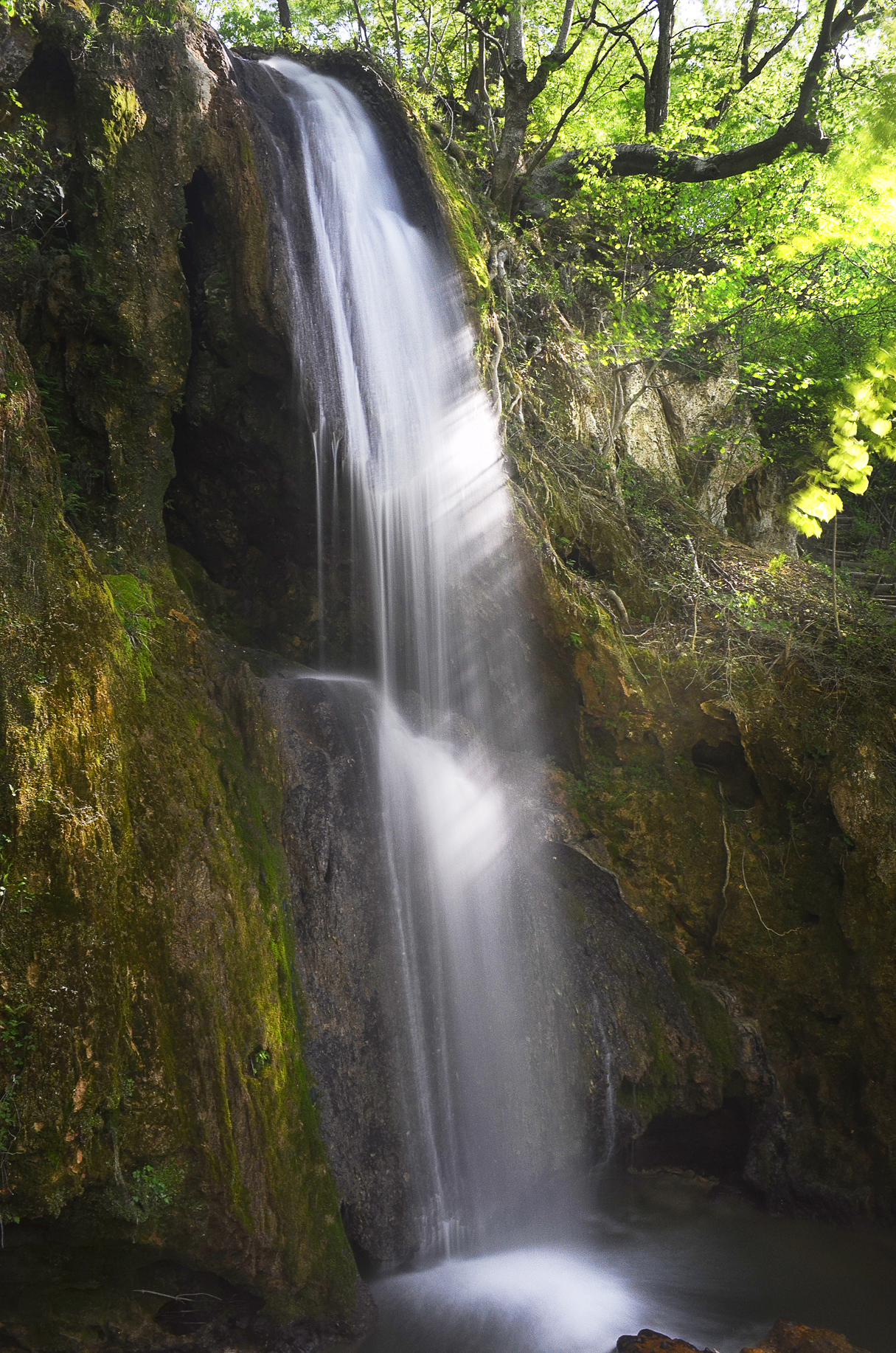
Waterfall Ripaljka. Photo: Jovana Mladenović.
GS 3 – Special Natural Reserve (SNR): “Rtanj” with pit filled with ice and karst microrelief. The Rtanj Mt. is a junction between the Sokobanja basin and the Crnorečka basin. It is built of limestone in the higher parts of the mountain and sandstone and shale in the lower parts [68]. The highest peak of this massive limestone ridge is called Šiljak, located on the eastern side of the mountain, reaching an elevation of 1,565 m [67]. Forms of surface karst microrelief created by fluvial erosion can be distinguished by exhumed or partially exhumed subcutaneous karst form (tubular scales and edges). These features adorn the southern parts of the slope. The Rtanj’s pit is a form of underground karst relief. It is better known as the Rtanjska Ledenica. It is located at the base of the peak Šiljak and has a depth of 45 m and a total length of 63 m. The pit consists of one oblique pit channel, and it belongs to the type of static freezers. It permanently retains cold air, and it has a constant temperature of 2°C [69].
GS 4 – The Seselac Cave is located in the northeastern part of the Sokobanja basin at the foot of the Slemen Mt. It presents the natural stone bridge (occur when the cave ceiling collapses) of the Zarvina River, which is complemented by a complex network of side channels. The main channel has a length of 70 m, and the length of all channels is 516 m. The cave has been repeatedly explored, but it is not equipped for tourist visits.
GS 5 – The Ozren Cave is located on Ozren Mt., on the part of the Ozren’s amphitheater basin, at the foot of peak Mečji Vrh (691 m). It is also known among the locals as the Delta Cave due to its entrance in the form of the Greek letter delta. It represents a typical tectonic-corrosive pit. It was created by submerging atmospheric waters along the cracks. It has a total length of 420 m. Although it has been repeatedly researched, it is not equipped for tourist visits.
GS 6 – The Urdeška River Gorge is located in the area of the village Milušinac at the footprint of the Krstatac Mt. (1,070 m). It originates from the Urdeška stream, the left tributary of the Milušinačka River. The area is rich in limestone and sandstone, with rocks of varying resistance to erosion. Numerous cascades and waterfalls have occurred in this area. The Big Cascade is a section on the Urdeška River that has a total height of 15 m. Downstream below, there are 15 large pots, also called vats. This large section is composed of hypurite limestone. There is another waterfall with a total height of 10 m on the Crnobarska stream. The waterfall is formed at the contact of limestone and marl. Due to differences in rock resistance to erosion, a smaller waterfall was created. The Waterfall on the Milušinačka River consists of several waterfalls of 7–8 m in height, formed on the contact of limestone and sandstone [67]. In the valley of the Milušinačka River, there are several smaller caves and dumps, as well as the natural stone bridge God’s Gate (Bogova vrata, in serbian) about 6 m high. This opening was created by the collapse of a former cave.
GS7 – The Čitluk Cave with the source of the Moravica River is located near the village Vrelo, at the foot of the Devica Mt. The Moravica River is formed by the merging of two streams at the foot of Devica Mt., i.e., the streams of Izgara and Tisovik. The Moravica River is 57 km long and has a catchment area of 606 km2. It is also fed by a spring, located in the village of Vrelo, 15 km east of Sokobanja. Since Izgara and Tisovik streams often dry up during the summer months, these springs in village Vrelo are considered to be the main source, which was named the Moravica Springs. It is located on the left side of the Moravica River. It gives an average of 650 L of water per second. The source is located at an altitude of 382 m [64]. The source itself is of particular importance because it forms a small lake that is fed by thousands of jets of water from the ground. The Čitluk Cave is located in the northeast rim of the Devica Mt. at the foot of a steep limestone cliff. It has a total length of 107 m. The main attraction is the large entrance hall, with a height of 23.5 m. There is an open hole in the ceiling of the cave, through which enters a daily light. It was created by the collapse of the ceiling. It has been repeatedly researched, but it is not yet equipped for tourist visits (Figures 4 and 5).

Čitluk Cave (entrance to the cave). Photo: Jovana Mladenović.

Source of the Moravica River. Photo: Jovana Mladenović.
4 Methodology
The methodology of this study is based on the “modified geosite assessment model” (M-GAM) developed by Tomić and Božić [23]. This method is based on the previous geosite assessment methods developed by different researchers [2,25,31,32,34,35,36,37,38,39,42], and represents a combination of the GAM model created by Vujičićet et al. [45] and the Im first introduced by Tomić [2] in his research. This model combines the opinion of both tourists and experts, and neither side is favored in the assessment process.
The M-GAM model consists of two key indicators: main values (MV) and additional values (AV), which are divided into 12 and 15 indicators, each of them individually marked from 0 to 1. The division is made due to two general types of values: main values – that are mostly generated by geosite’s natural characteristics and additional values – that are mostly human induced and generated by modifications for its use by visitors. The main values comprise three groups of indicators: scientific/educational (VSE), scenic/aesthetical values (VSA), and protection (VPr), while the additional values are divided into two groups of indicators, functional (VFn) and touristic values (VTr). The main and additional values are more detailed in Table 1. In total, there are 12 subindicators of main values and 15 subindicators of additional values that are assessed from 0 to 1 that define M-GAM as a simple equation:
where MV and AV represent symbols for main and additional values. Since main and additional values consist of three or two groups of subindicators, we can derive these two equations:
Subindicator values given by experts for each analyzed geosite
| Values given by experts (0–1) | Im | Total value | |||||||||||||
|---|---|---|---|---|---|---|---|---|---|---|---|---|---|---|---|
| GS1 | GS2 | GS3 | GS4 | GS5 | GS6 | GS7 | GS1 | GS2 | GS3 | GS4 | GS5 | GS6 | GS7 | ||
| Main values (MV) | |||||||||||||||
| Scientific/educational values (VSE) | |||||||||||||||
| 1. Rarity (SIMV1) | 0.50 | 0.50 | 0.25 | 0.25 | 0.25 | 0.25 | 0.25 | 0.89 | 0.44 | 0.44 | 0.22 | 0.22 | 0.22 | 0.22 | 0.22 |
| 2. Representativeness (SIMV2) | 0.75 | 0.75 | 0.50 | 0.25 | 0.25 | 0.50 | 0.50 | 0.79 | 0.59 | 0.59 | 0.39 | 0.19 | 0.19 | 0.39 | 0.39 |
| 3. Knowledge on geoscientific issues (SIMV3) | 0.75 | 0.75 | 0.75 | 0.50 | 0.25 | 0.25 | 0.25 | 0.45 | 0.33 | 0.33 | 0.33 | 0.22 | 0.12 | 0.12 | 0.12 |
| 4. Level of interpretation (SIMV4) | 1.00 | 1.00 | 1.00 | 0.75 | 0.75 | 0.75 | 0.75 | 0.85 | 0.85 | 0.85 | 0.85 | 0.64 | 0.64 | 0.64 | 0.64 |
| Scenic/aesthetic (VSA) | |||||||||||||||
| 5. Viewpoints (SIMV5) | 1.00 | 0.50 | 1.00 | 0.25 | 0.50 | 0.75 | 0.75 | 0.79 | 0.79 | 0.39 | 0.79 | 0.20 | 0.39 | 0.59 | 0.59 |
| 6. Surface (SIMV6) | 0.50 | 0.00 | 1.00 | 0.50 | 0.00 | 0.00 | 0.50 | 0.54 | 0.27 | 0.00 | 0.54 | 0.27 | 0.00 | 0.00 | 0.27 |
| 7. Surrounding landscape and nature (SIMV7) | 0.75 | 0.75 | 1.00 | 0.75 | 0.75 | 0.75 | 0.75 | 0.95 | 0.71 | 0.71 | 0.95 | 0.71 | 0.71 | 0.71 | 0.71 |
| 8. Environmental fitting of sites (SIMV8) | 1.00 | 1.00 | 1.00 | 1.00 | 1.00 | 1.00 | 1.00 | 0.68 | 0.68 | 0.68 | 0.68 | 0.68 | 0.68 | 0.68 | 0.68 |
| Protection (VPr) | |||||||||||||||
| 9. Current condition (SIMV9) | 0.75 | 1.00 | 0.75 | 0.50 | 0.50 | 0.75 | 0.75 | 0.83 | 0.62 | 0.83 | 0.62 | 0.41 | 0.41 | 0.62 | 0.62 |
| 10. Protection level (SIMV10) | 0.75 | 0.75 | 0.75 | 0.00 | 0.00 | 0.00 | 0.00 | 0.76 | 0.57 | 0.57 | 0.57 | 0.00 | 0.00 | 0.00 | 0.00 |
| 11. Vulnerability (SIMV11) | 0.75 | 0.50 | 0.75 | 0.50 | 0.50 | 0.50 | 0.50 | 0.58 | 0.43 | 0.29 | 0.43 | 0.29 | 0.29 | 0.29 | 0.29 |
| 12. Suitable number of visitors (SIMV12) | 1.00 | 0.50 | 1.00 | 0.25 | 0.25 | 0.25 | 0.50 | 0.42 | 0.42 | 0.21 | 0.42 | 0.11 | 0.11 | 0.11 | 0.21 |
| Additional values (AVs) | |||||||||||||||
| Functional values (VFn) | |||||||||||||||
| 13. Accessibility (SIAV1) | 0.75 | 1.00 | 0.25 | 0.50 | 0.50 | 0.25 | 0.75 | 0.75 | 0.56 | 0.75 | 0.19 | 0.37 | 0.37 | 0.19 | 0.56 |
| 14. Additional natural values (SIAV2) | 1.00 | 0.50 | 1.00 | 0.25 | 0.25 | 0.50 | 0.50 | 0.71 | 0.71 | 0.35 | 0.71 | 0.18 | 0.18 | 0.35 | 0.35 |
| 15. Additional anthropogenic values (SIAV3) | 0.50 | 0.00 | 0.25 | 0.00 | 0.00 | 0.25 | 0.25 | 0.70 | 0.35 | 0.00 | 0.18 | 0.00 | 0.00 | 0.18 | 0.18 |
| 16. Vicinity of emissive centers (SIAV4) | 0.25 | 0.25 | 0.25 | 0.25 | 0.25 | 0.25 | 0.25 | 0.48 | 0.12 | 0.12 | 0.12 | 0.12 | 0.12 | 0.12 | 0.12 |
| 17. Vicinity of important road network (SIAV5) | 0.50 | 0.50 | 0.50 | 0.50 | 0.50 | 0.50 | 0.50 | 0.62 | 0.31 | 0.31 | 0.31 | 0.31 | 0.31 | 0.31 | 0.31 |
| 18. Additional functional values (SIAV6) | 0.50 | 0.50 | 0.00 | 0.00 | 0.00 | 0.00 | 0.50 | 0.59 | 0.29 | 0.29 | 0.00 | 0.00 | 0.00 | 0.00 | 0.29 |
| Touristic values (VTr) | |||||||||||||||
| 19. Promotion (SIAV7) | 0.75 | 0.75 | 0.50 | 0.25 | 0.25 | 0.25 | 0.25 | 0.85 | 0.64 | 0.64 | 0.42 | 0.21 | 0.21 | 0.21 | 0.21 |
| 20. Organized visits (SIAV8) | 0.25 | 0.00 | 0.25 | 0.00 | 0.00 | 0.00 | 0.25 | 0.56 | 0.14 | 0.00 | 0.14 | 0.00 | 0.00 | 0.00 | 0.14 |
| 21. Vicinity of visitors centers (SIAV9) | 0.00 | 0.00 | 0.00 | 0.00 | 0.00 | 0.00 | 0.00 | 0.87 | 0.00 | 0.00 | 0.00 | 0.00 | 0.00 | 0.00 | 0.00 |
| 22. Interpretative panels (SIAV10) | 0.50 | 0.75 | 0.00 | 0.00 | 0.00 | 0.00 | 0.00 | 0.81 | 0.40 | 0.61 | 0.00 | 0.00 | 0.00 | 0.00 | 0.00 |
| 23. Number of visitors (SIAV11) | 0.50 | 0.75 | 0.50 | 0.25 | 0.00 | 0.00 | 0.25 | 0.43 | 0.21 | 0.32 | 0.21 | 0.11 | 0.00 | 0.00 | 0.11 |
| 24. Tourism infrastructure (SIAV12) | 0.50 | 0.50 | 0.00 | 0.00 | 0.00 | 0.00 | 0.00 | 0.73 | 0.36 | 0.36 | 0.00 | 0.00 | 0.00 | 0.00 | 0.00 |
| 25. Tour guide service (SIAV13) | 0.00 | 0.00 | 0.00 | 0.00 | 0.00 | 0.00 | 0.00 | 0.87 | 0.00 | 0.00 | 0.00 | 0.00 | 0.00 | 0.00 | 0.00 |
| 26. Hostelry service (SIAV14) | 1.00 | 1.00 | 0.25 | 0.25 | 0.75 | 0.25 | 0.50 | 0.73 | 0.73 | 0.73 | 0.18 | 0.18 | 0.55 | 0.18 | 0.36 |
| 27. Restaurant service (SIAV15) | 1.00 | 1.00 | 0.25 | 0.25 | 0.75 | 0.25 | 0.50 | 0.78 | 0.78 | 0.78 | 0.19 | 0.19 | 0.58 | 0.19 | 0.39 |
GS1 – Outstanding Natural Landscape (ONL) “Lepterija-Sokograd,” GS2 – Monument of Nature (MN) Waterfall “Ripaljka,” GS3 – Special Natural Reserve (SNR) “Rtanj,” GS4 – Seselac Cave, GS5 – Ozren Cave, GS6 – Urdeška Gorge, GS7 – Čitluk Cave with the source of the Moravica River
Each group of indicators consists of several subindicators, equations (2) and (3) can be written as follows:
Values SIMVi and SIAVj represent 12 subindicators of main values (i = 1,…,12) and 15 subindicators (j = 1,…,15) of additional values. The main distinction of M-GAM is that its focus is on the expert’s opinion and the opinion of visitors and tourists regarding the importance of each indicator in the assessment process. Visitors and tourists’ inclusion in the assessment process is made through a survey where each respondent is asked to rate the importance (Im) of all 27 subindicators (from 0.00 to 1.00) in the M-GAM model (Table 2). The Im allows visitors and tourists to express their opinion about each subindicator in the model and to show how important it is for them when choosing and deciding between several geosites that they wish to visit. After each respondent rates, the importance of every subindicator, the average value of each subindicator is calculated and the final value of that subindicator is the Im. Afterward, the value of the Im is multiplied with the value that was given by experts (also from 0.00 to 1.00) who assessed the current state and value of each subindicator (Table 2).
Structure of M-GAM model values
| Indicators/subindicators | Description | ||||
|---|---|---|---|---|---|
| Main values (MV) | |||||
| Scientific/educational value (VSE) | |||||
| 1. Rarity | Number of closest identical sites | ||||
| 2. Representativeness | Didactic and exemplary characteristics of the site due to its own quality and general configuration | ||||
| 3. Knowledge on geoscientific issues | Number of written papers in acknowledged journals, thesis, presentations, and other publications | ||||
| 4. Level of interpretation | Level of interpretive possibilities on geological and geomorphologic processes, phenomena and shapes and level of scientific knowledge | ||||
| Scenic/aesthetic (VSA) | |||||
| 5. Viewpoints | Number of viewpoints accessible by a pedestrian pathway. Each must present a particular angle of view and be situated less than 1 km from the site. | ||||
| 6. Surface | Whole surface of the site. Each site is considered in quantitative relation to other sites | ||||
| 7. Surrounding landscape and nature | Panoramic view quality, presence of water and vegetation, absence of human-induced deterioration, vicinity of urban area, etc. | ||||
| 8. Environmental fitting of sites | Level of contrast to the nature, contrast of colors, appearance of shapes, etc. | ||||
| Protection (VPr) | |||||
| 9. Current condition | Current state of geosite | ||||
| 10. Protection level | Protection by local or regional groups, national government, international organizations, etc. | ||||
| 11. Vulnerability | Vulnerability level of geosite | ||||
| 12. Suitable number of visitors | Proposed number of visitors on the site at the same time, according to the surface area, vulnerability, and current state of geosite | ||||
| Additional values (AVs) | |||||
| Functional values (VFns) | |||||
| 13. Accessibility | Possibilities of approaching to the site | ||||
| 14. Additional natural values | Number of additional natural values in the radius of 5 km (geosites also included) | ||||
| 15. Additional anthropogenic values | Number of additional anthropogenic values in the radius of 5 km | ||||
| 16. Vicinity of emissive centers | Closeness of emissive centers | ||||
| 17. Vicinity of important road network | Closeness of important road networks in the in radius of 20 km | ||||
| 18. Additional functional values | Parking lots, gas stations, mechanics, etc. | ||||
| Touristic values (VTr) | |||||
| 19. Promotion | Level and number of promotional resources | ||||
| 20. Organized visits | Annual number of organized visits to the geosite | ||||
| 21. Vicinity of visitors centers | Closeness of visitor center to the geosite | ||||
| 22. Interpretative panels | Interpretative characteristics of text and graphics, material quality, size, fitting to surroundings, etc. | ||||
| 23. Number of visitors | Annual number of visitors | ||||
| 24. Tourism infrastructure | Level of additional infrastructure for tourist (pedestrian pathways, resting places, garbage cans, toilets, etc.) | ||||
| 25. Tour guide service | If exists, expertise level, knowledge of foreign language(s), interpretative skills, etc. | ||||
| 26. Hostelry service | Hostelry service close to geosite | ||||
| 27. Restaurant service | Restaurant service close to geosite | ||||
| Grades (0.00–1.00) | 0.00 | 0.25 | 0.50 | 0.75 | 1 |
| 1. Rarity | Common | Regional | National | International | The only occurrence |
| 2. Representativeness | None | Low | Moderate | High | Utmost |
| 3. Knowledge on geoscientific issues | None | Local publications | Regional publications | National publications | International publications |
| 4. Level of interpretation | None | Moderate level of processes but hard to explain to non-experts | Good example of processes but hard to explain to nonexperts | Moderate level of processes but easy to explain to common visitor | Good example of processes and easy to explain to common visitor |
| 5. Viewpoints | None | 1 | 2 to 3 | 4 to 6 | More than 6 |
| 6. Surface | Small | — | Medium | — | Large |
| 7. Surrounding landscape and nature | — | Low | Medium | High | Utmost |
| 8. Environmental fitting of sites | Unfitting | — | Neutral | — | Fitting |
| 9. Current condition | Totally damaged (as a result of human activities) | Highly damaged (as a result of natural processes) | Medium damaged (with essential geomorphologic features preserved) | Slightly damaged | No damage |
| 10. Protection level | None | Local | Regional | National | International |
| 11. Vulnerability | Irreversible (with possibility of total loss) | High (could be easily damaged) | Medium (could be damaged by natural processes or human activities) | Low (could be damaged only by human activities) | None |
| 12. Suitable number of visitors | 0 | 0–10 | 10–20 | 20–50 | More than 50 |
| 13. Accessibility | Inaccessible | Low (on foot with special equipment and expert guide tours) | Medium (by bicycle and other means of man-powered transport) | High (by car) | Utmost (by bus) |
| 14. Additional natural values | None | 1 | 2–3 | 4–6 | More than 6 |
| 15. Additional anthropogenic values | None | 1 | 2–3 | 4–6 | More than 6 |
| 16. Vicinity of emissive centers | More than 100 km | 100–50 km | 50–25 km | 25–5 km | Less than 5 km |
| 17. Vicinity of important road network | None | Local | Regional | National | International |
| 18. Additional functional values | None | Low | Medium | High | Utmost |
| 19. Promotion | None | Local | Regional | National | International |
| 20. Organized visits | None | Less than 12 per year | 12–24 per year | 24–48 per year | More than 48 per year |
| 21. Vicinity of visitors centers | More than 50 km | 50–20 km | 20–5 km | 5–1 km | Less than 1 km |
| 22. Interpretative panels | None | Low quality | Medium quality | High quality | Utmost quality |
| 23. Number of visitors | None | Low (less than 5,000) | Medium (5,001–10,000) | High (10,001–100,000) | Utmost (more than 100,000) |
| 24. Tourism infrastructure | None | Low | Medium | High | Utmost |
| 25. Tour guide service | None | Low | Medium | High | Utmost |
| 26. Hostelry service | More than 50 km | 25–50 km | 10–25 km | 5–10 km | Less than 5 km |
| 27. Restaurant service | More than 25 km | 10–25 km | 10–5 km | 1–5 km | Less than 1 km |
Source: Adapted from Vujičić et al. [45].
This is done for each subindicator in the M-GAM model after which the values are added up according to the M-GAM equation, but this time with more objective and accurate final results due to the addition of the Im. This parameter is determined by visitors and tourists who rate it in the same way as experts rate the subindicators for main and additional values by giving them one of the following numerical values: 0.00, 0.25, 0.50, 0.75, and 1.00, marked as points. According to this, the Im is defined as follows:
where Ivk is the assessment/score of one visitor for each subindicator and K is the total number of visitors. Note that the Im parameter can have any value ranging from 0.00 to 1.00. Finally, the M-GAM equation is defined and presented in the following form:
As can be seen from the M-GAM equation, the value of the Im, which is rated by visitors (for each subindicator separately) is multiplied with the value given by experts (also separately for each subindicator). This is done for each subindicator in the model.
Authors Božić and Tomić [24] conducted a survey in their research about different geotouristic segments and calculated the Im for each subindicator in the M-GAM model related to Serbian tourists. For this research, the values of the Im have been adopted from ref. [24].
Based on the results obtained, a matrix of main values (X-axes) and additional values (Y axes) is created (Figure 7). The matrix is divided into nine fields represented with Z(i,j), (i, j = 1, 2, 3). Depending on the final score, each geosite will fit into a certain field. For example, if a geosite’s main values are 6 and additional are 8, the geosite will fit into the field Z22.

(a) Urdeška river gorge (Natural stone bridge – God’s Gate). Photo: Jovana Mladenović. (b) Urdeška river gorge (Small cave). Photo: Jovana Mladenović.
5 Results and discussion
In this study, seven previously described geosites in the Sokobanja basin were assessed by using the M-GAM methodology. The aim of this article is to compare their current state and geotourism potential and reveal the most suitable geosites for the initial geotourism development of the Sokobanja basin. Final results of the assessment are presented in Tables 1 and 3 and Figure 7.
Overall ranking of the analyzed geosites by M–GAM
| Geosite | Main values (MV) | ∑ | Additional values (AV) | ∑ | Field | |||
|---|---|---|---|---|---|---|---|---|
| VSE | VSA | VPr | VFn | VTr | ||||
| GS 1 | 2.21 | 2.45 | 2.04 | 6.70 | 2.34 | 3.26 | 5.60 | Z22 |
| GS 2 | 2.21 | 1.78 | 1.90 | 5.89 | 1.82 | 3.44 | 5.26 | Z22 |
| GS 3 | 1.79 | 2.96 | 2.04 | 6.79 | 1.51 | 1.14 | 2.65 | Z12 |
| GS 4 | 1.27 | 1.86 | 0.81 | 3.94 | 0.98 | 0.69 | 1.67 | Z11 |
| GS 5 | 1.17 | 1.78 | 0.81 | 3.76 | 0.98 | 1.34 | 2.32 | Z11 |
| GS 6 | 1.37 | 1.98 | 1.02 | 4.37 | 1.15 | 0.58 | 1.73 | Z12 |
| GS 7 | 1.37 | 2.25 | 1.12 | 4.74 | 1.81 | 1.21 | 3.02 | Z12 |
GS1 – Outstanding Natural Landscape (ONL) “Lepterija-Sokograd,” GS2 – Monument of Nature (MN) Waterfall “Ripaljka,” GS3 – Spacial Natural Reserve (SNR) “Rtanj,” GS4 – Seselac Cave, GS5 – Ozren Cave, GS6 – Urdeška Gorge, GS7 – Čitluk Cave with the source of the Moravica River.

Position of geosites in M-GAM matrix. Legend: GS1 – Outstanding Natural Landscape (ONL) “Lepterija-Sokograd,” GS2 – Monument of Nature (MN) Waterfall “Ripaljka,” GS3 – Spacial Natural Reserve (SNR) “Rtanj,” GS4 – Seselac Cave, GS5 – Ozren Cave, GS6 – Urdeška Gorge, and GS7 – Čitluk Cave with the source of the Moravica River.
Results presented in Tables 1 and 3 show that the main values have a significantly higher score than the additional values. This indicates a great potential for the development of geotourism, but these potentials are not fully utilized. Geosites with the highest main values are ONL Lepterija – Sokograd (6.70), MN Ripaljka Waterfall (5.89), and SNR Rtanj (6.79). The first two geosites possess very high scientific values (VSEs), especially in the case of rarity, representativeness, and level of interpretation, while SNR Rtanj has a slightly lower score. Conversely, geosites SNR Rtanj and ONL Lepterija-Sokograd have the highest aesthetic values (VSA), particularly regarding viewpoints, surface, and surrounding landscape and nature. These geosites have the biggest surface among assessed geosites. Geosite MN Ripaljka Waterfall has slightly a lower score due to small surface. Due to the high values of the Im of rarity, level of interpretation, and surrounding landscape and nature, the first three geosites have the highest main values. The slightly lower score of main values has geosite Čitluk Cave with a source of Moravica River (4.74), which possesses exceptional aesthetic and curiosity values. Namely, the picturesque mountain environment, the source of the Moravica River, where hundreds of jets of spring water erupt from the ground as well as the cave in the immediate vicinity, attracts a large number of visitors during the year. On the other side, geosites with the lowest score of main values are Ozren Cave and Seselačka Cave. These geosites cover a small area and have a low level of knowledge on geoscientific issues and viewpoints. Also, these caves have poorly expressed karst processes and do not possess speleothems. Geosites ONL Lepterija – Sokograd and SNR Rtanj and MN Ripaljka Waterfall are the only protected areas on a national level among the analyzed geosites, while other geosites do not have any form of protection. The highest score of protection values have ONL Lepterija-Sokograd and SNR Rtanj. These two geosites cover a huge area, which enables the visit of a big group of tourists without causing significant damage to the ecosystem. Geosite MN Waterfall Ripaljka has a slightly lower score because it covers a small area, and a big group of tourists can harm the ecosystem. For other geosites without any kind of protection, it is necessary to provide an initial form of protection at the local level and then to increase the level of protection through development and research of these areas, because geoconservation is a vital part of geotourism. First, it is necessary to implement the initial form of protection of the Seselac Cave because it is home to a large and rare colony of bats. This geosite requires special attention when planning tourism development due to the implementation of geoconservation.
Additional values are added values to a geosite for visitors use. These values are very important for further geotourism development. In Tables 1 and 3, the overall score of additional values is presented for each evaluated geosite. Geosites ONL Lepterija-Sokograd (5.60) and MN Waterfall Ripaljka (5.26) have the highest score of additional values, which means that these geosites are currently the most suitable for tourism activities.
In the case of functional values (VFn), geosite ONL Lepterija-Sokograd has the highest score, because it is easily accessible by car and smaller bus and have numerous additional natural and anthropogenic values. The Sokobanja basin is located 60 km away from the main tourist corridor of Serbia and southeastern Europe (E-75 highway), and it is easily accessible by a regional road network with good quality. However, the road network leading from the center of Sokobanja to the assessed geosites is local and has low quality. Geosite Urdeška River gorge has the lowest score based on accessibility because this geosite is connected to the main road by a narrow forest road limiting access, especially during rainy periods. Due to the high score of Im for accessibility, it is necessary to build up a quality road network. Sokobanja is more than 250 km away from the main emissive tourist areas, Belgrade and Novi Sad, which are the largest cities in Serbia according to the population. The city of Niš is the only city with a population of over 200,000 located less than 100 km away from Sokobanja. This is the main reason for the low score of all assessed geosites regarding the vicinity of emissive centers.
The natural surroundings of Sokobanja is very attractive for tourists and visitors. Numerous natural values such as thermo-mineral springs, surface and underground karst relief forms, numerous endemic herbs and animal species, as well as local architecture and cultural heritage increase the attractiveness of this area. Geosite NLO Lepteria-Sokograd has the highest score according to this subindicator because the surrounding landscape and environment of this area is one of the most picturesque, not only among the analyzed geosites but also in the entire region. Regarding additional functional values, the big problem of further tourism development is the lack of parking spaces. Apart from the geosites MN Ripaljka Waterfall, not one geosite has a parking lot for buses and cars.
Tourism values are very important for the promotion and development of geotourism. By analyzing the tourist values (VTr) of all geosites, it can be noticed that the MN Waterfall Ripaljka has the highest score of tourist values (3.44). The main reason for such high tourist values is related to the number of visitors, promotion, hostelry, and restaurant services. This geosite is a landmark of Sokobanja and a well-known waterfall in Serbia. The slightly lower score has geosite NLO Lepterija-Sokograd (3.26) due to a higher number of visitors and higher quality of interpretative boards of MN Waterfall Ripaljka. Geosites Seselac Cave and Urdeška River gorge have the lowest score of tourist values. The main reason for such low tourist values is related to basic geosite infrastructure, interpretive panels, number of visitors, and promotion. All of these elements are nonexistent at these geosites. Due to the high Im for these subindicators, these elements should be the primary focus of future tourism development to attract more visitors to the sites.
Promotional activities of all geosites are on local and regional levels within the promotional activities of the Tourist Organization of Sokobanja. The official website of the Tourist Organization of Sokobanja [70] promotes several geosites (GS1, GS2, GS3, GS4, and GS7), while GS5 and GS6 have no promotional activities at all. Given that the funds assigned to promotional activities are very limited, it is necessary to take advantage of the popularity, wide coverage area, and low cost of advertising via electronic media. This primarily refers to the use of Internet marketing and promotional activities that represent one of the key trends in contemporary marketing strategies [71]. When it comes to organized tourist visits, it can be observed that only MN Waterfall Ripaljka has 12–24 organized visits per year, as this geosite is often in student excursion programs. Geosites NLO Lepterija-Sokograd and SNR Rtanj Mt. have less than 12 organized visits during the year. These geosites are often visited by hikers and nature lovers. If we look at the number of visitors, geosite MN Waterfall Ripaljka has the highest number of visitors between 10,000 and 100,000 visitors during the year. Waterfall Ripaljka is one of the landmarks of Sokobanja. It is one of the highest waterfalls in Serbia (total height of 40 m), and it has exceptional aesthetic and curiosity values, which is the reason why it is the most visited attraction of Sokobanja. Geosites ONL Lepterija – Sokograd and SNR Rtanj Mt. are visited by more than 5,000 visitors during the year because they represent the main excursion sites of Sokobanja.
When it comes to the interpretative boards, geosite MN Waterfall Ripaljka has a medium quality of interpretative panels. Other geosites have a poor quality of interpretative panels or these elements are nonexistent at geosites. Interpretive panels, in the absence of a guide, simplify complex natural processes; provide meaningful information about the geosite, the length of the tourist trail, rules, and warnings; and facilitate the movement of visitors. Therefore, it is necessary to significantly improve the number and the quality of interpretative panels to increase the overall tourist experience. Sokobanja does not have an organized guide service. Quality and multilingual guide service is a very important factor in the development of geotourism. Tourists are often people who know little about geological and geomorphological processes, so a good interpretation is necessary to understand complex processes [72]. Sokobanja does not have a visitor center. As all localities are not so far from Sokobanja, one visitor center can be built to present all geosites ex situ and promote them. The role of visitor centers is multifaceted. Tourists can get more information about geosites from these visitor centers. With the simulation of some natural processes, visitors can get close to complex geological and geomorphological processes. Visitor centers can present the characteristic flora and fauna, as well as the history and culture of the area. Sokobanja is a place with a long tradition of organized tourism, so it has a large number of accommodation facilities and restaurant services. Geosites closest to the center of Sokobanja (NLO Lepterija-Sokograd and MN Waterfall Ripaljka) have the highest rating according to this subindicator because most of the accommodation and restaurant facilities are located there. Other geosites are far from the center of Sokobanja and have a lower score. Given the fact that the Im for promotion, vicinity of visitor centers, interpretative panels, and tour guide service are among the highest in the M-GAM model by Serbian tourists, these elements should be the primary focus of future tourism development to attract more visitors to the site.
According to the overall score of MV and AV of evaluated geosites, each of them will fit into a certain field in a two-dimensional M-GAM matrix. Only two geosites (NLO Lepterija-Sokograd and MN Waterfall Ripaljka) are located in the field Z22. This indicates that these two sites have the most potential for future development of geotourism among the evaluated geosites. Geosites Seselac Cave and Ozren Cave are located in field. These geosites are not equipped for tourist visits and do not have high aesthetic value. They cover a small area, and they are not suitable for mass tourism development. These caves have the potential to develop modern “Wild Caving” tourism, which is more ecotourism oriented. Geosites SNR Rtanj Mt., Urdeška river gorge, and Čitlik Cave with Moravice river source are located in field Z12. Generally, geosites of Sokobanja are characterized by a moderate level of main values and moderate or low level of additional values. Future geotourism development should primarily be focused on geosites NLO Lepterija-Sokograd and MN Waterfall Ripaljka, which have a very good balance of main and additional values but still with plenty of room for improvement. Geosite SNP Rtanj Mt. has the highest main values, especially aesthetic values that are an important motive for tourists. Even so, more investments and improvement is necessary in the case of tourist values to attract a larger number of tourists and visitors in the future period. This especially refers to tour guide service, interpretive panels, as well as promotion and visitor centers.
In addition, further geotourism development should be based on the use of Geographical information system (GIS). A GIS presents a valuable tool, providing an opportunity for quick management and complex processing of spatial data, while the user of the GIS is capable of implementing them in the decision-making procedure [73]. The utilization of geological, geomorphological, and socioeconomic data should help in better land use suitability assessment procedure for geotourism development. The incorporation of these factors assists decision-makers, policy-makers, and planners in the evaluation and the selection of suitable areas for the development of geotourism. A similar study was conducted by Bathrellos et al. [74]. In their research, they examined the potential land use planning for rural communities and agricultural development with the help of multi criteria analysis and GIS.
6 Conclusion
The main focus of this study was to assess and compare the current state and geotourism potential of the seven analyzed geosites in the Sokobanja basin. All seven geosites have a significant tourism potential, which is based on natural resources, especially aesthetic values. However, as our results show, none of these sites have the necessary services and facilities for major tourism development. It is indisputable that Sokobanja possesses the resources for the development of geotourism, but the necessary thing is human activity aimed at the management of geosites and tourist destinations as a whole. A big problem for further tourism development is the lack of guide service. This segment of the tourism market requires guided tours, so good quality tour guide service should be available. Another important issue is the lack of a visitor center in the area. It is not necessary to have a large visitor center in the initial phase of the geotourism development. One visitor center located in Sokobanja would be a sufficient start. This visitor center would be equipped with knowledgeable staff and modern interpretative facilities and other tourist contents. Onsite interpretation and geosite signage and signalization is of low quality or nonexistent at all. Although geotourism is even now based on self-guided tours, geosites should have brochures and maps of geosite attractions to support self-guided tours. The development of geotourism in Sokobanja would enrich its tourist offer. Sokobanja should recognize its geotourism potential as an upgrade to the overall tourist offer. More diverse offers can attract tourists of different interests. Geotourism can have a positive impact on economic flows. Further development of geotourism in this area can identify some new geosites and expand the geotourism offer.
Acknowledgments
This article is the result of research on the project Development Programs for the Revitalization of the Village of Serbia, funded by the Serbian Ministry of Education and Science.
References
[1] Djurović P, Mijović D. Geoheritage of Serbia-representative of its total geodiversity, Collect Pap – Faculty Geography, Univ Belgrade. 2006;54:5–18.Search in Google Scholar
[2] Tomić N. The potential of Lazar Canyon (Serbia) as a geotourism destination: Inventory and evaluation. Geographica Pannonica. 2011;15:103–12.10.5937/GeoPan1103103TSearch in Google Scholar
[3] Ruban DA. Geotourism – A geographical review of the literature. Tour Manag Perspect. 2015;15:1–15.10.1016/j.tmp.2015.03.005Search in Google Scholar
[4] Štrba Ľ. Analysis of criteria affecting geo-site visits by general public: A case of Slovak (geo)tourists. Geoheritage. 2019;11:291–300.10.1007/s12371-018-0283-2Search in Google Scholar
[5] Dowling RK. The emergence of geotourism and geoparks. J Tour. 2008;IX(2):227–36.Search in Google Scholar
[6] Dowling RK. Newsome D. Geotourism. Oxford: Elsevier; 2006.10.4324/9780080455334Search in Google Scholar
[7] Dowling RK, Newsome D. Global geotourism perspectives. Oxford: Goodfellow Publishers; 2010.10.23912/978-1-906884-17-8-1146Search in Google Scholar
[8] Joyce EB. Geomorphological Sites and the New Geotourism in Australia. Melbourne: Geological Society of Australia; 2006. http://web.earthsci.unimelb.edu.au/Joyce/heritage/GeotourismReviewebj.htm.10.1071/ASEG2006ab078Search in Google Scholar
[9] Gray M. Geodiversity: Developing the paradigm. Proc Geologists’ Assoc. 2008;119:287–98.10.1016/S0016-7878(08)80307-0Search in Google Scholar
[10] Suzuki AD, Takagi H. Evaluation of geosite for sustainable planning and management in Geotourism. Geoheritage. 2018;10:123–35. 10.1007/s12371-017-0225-4.Search in Google Scholar
[11] Sadry BN. Fundamentals of Geotourism: With special emphasis on Iran. Tehran, Iran: Samt publisher; 2009.Search in Google Scholar
[12] Hose TA. Selling the story of Britain’s stone. Environ Interpret. 1995;10(2):16–7.Search in Google Scholar
[13] Hose TA. Geotourism, or can tourists become casual rock hounds? Bennett MR, Doyle P, Larwood JG, Prosser CD, editors. Geology on your Doorstep. Geological Society; 1996. p. 207–28.Search in Google Scholar
[14] Hose TA. European geotourism – geological interpretation and geoconservation promotion for tourists. In: Barretino D, Wimbledon WP, Gallego E, editors. Geological Heritage: Its Conservation and Management. Madrid: Instituto Tecnologico Geominero de Espana; 2000. p. 127–46.Search in Google Scholar
[15] Hose TA. Geo-tourism - appreciating the deep side of landscapes. In: Novelli M, editor. Niche Tourism; contemporary issues, trends and cases. Oxford, UK: Elsevier Science; 2005. p. 27–37.10.1016/B978-0-7506-6133-1.50010-XSearch in Google Scholar
[16] Hose TA. Towards a history of geotourism: Definitions, antecedents and the future. In: Burek CV, Prosser CD, editors. The History of Geoconservation (Special Publication 300). London: Geological Society, London; 2008. p. 37–60.10.1144/SP300.5Search in Google Scholar
[17] Hose TA, Vasiljević DJA. Defining the nature and purpose of modern geotourism with particular reference to the United Kingdom and South-East Europe. Geoheritage. 2012;4(1–2):25–43.10.1007/s12371-011-0050-0Search in Google Scholar
[18] Wimbledon WAP. National site selection, a stop on the road to a European Geosites list. Geologica Balcania. 1996;26(1):5–27.Search in Google Scholar
[19] Röhling HG, Schmidt-Thomé M. Geoscience for the public: Geotopes and National GeoParks in Germany. Episodes. 2004;27(4):279–83.10.18814/epiiugs/2004/v27i4/007Search in Google Scholar
[20] Ilies D, Josan N. Geosites-geomorphosites and relief. Geoj Tour Geosites. 2009;3(1):Year II, Editura UniversităŃii din Oradea 78–85.Search in Google Scholar
[21] Panizza M, Piacente S. Geomorfologia Culturale. Bologna: Piatogora Editrice; 2003.Search in Google Scholar
[22] Reynard E. Geosite. In: Goudie A, editor. Encyclopedia of Geomorphology. London: Routledge; 2004.Search in Google Scholar
[23] Tomić N, Božić S. A modified geosite assessment model (MGAM) and its application on the Lazar Canyon area (Serbia). Int J Env Res. 2014;8(4):1041–52.Search in Google Scholar
[24] Božić S, Tomić N. Canyons and gorges as potential geotourism destinations in Serbia: Comparative analysis from two perspectives – general geotourists’ and pure geotourists’. Open Geosci. 2015;7:531–46. 10.1515/geo-2015-0040Search in Google Scholar
[25] Reynard E. Scientific research and tourist promotion of geomorphological heritage. Geogr Fis E Dinamica Quaternaria. Turin 2008;31(2):225–30.Search in Google Scholar
[26] Rivas V, Rix K, Frances E, Cendrero A, Brundsden D. Geomorphological indicators for environmental impact assessment: Consumable and non-consumable geomorphological resources. Geomorphology. 1997;18:169–82.10.1016/S0169-555X(96)00024-4Search in Google Scholar
[27] Cendrero A, Panizza M. Geomorphology and environmental impact assessment: An introduction. Supplementi di Geogr Fis Dinamica Quaternaria. Turin 1999;3(3):167–72.Search in Google Scholar
[28] Stürm B. The geotope concept: Geological nature conservation by town and country planning. Geological and Landscape Conservation. London: Malvern International Conference; 1994Search in Google Scholar
[29] Grandgirard V. L’évaluation des géotopes. Geologia Insubrica. Milano 1999;4(1):59–66.Search in Google Scholar
[30] Bonachea J, Bruschi V, Remondo J, González-Díez A, Salas L, Berten J, et al. An approach for quantifying geomorphological impacts for EIA of transportation infrastructures: A case study in northern Spain. Geomorphology. 2005;66(1–4):95–117. 10.1016/j.geomorph.2004.09.008Search in Google Scholar
[31] Coratza P, Giusti C. Methodological proposal for the assessment of the scientific quality of geomorphosites. Il Quaternario. 2005;18:1.Search in Google Scholar
[32] Bruschi VM, Cendrero A. Geosite evaluation. Can we measure intangible values? Il Quaternario. 2005;18:1.Search in Google Scholar
[33] Panizza M. Geomorphosites, concepts, methods, and examples of geomorphological survey. Chin Sci Bull. 2001;46:4–6.10.1007/BF03187227Search in Google Scholar
[34] Pralong JP. A method for assessing the tourist potential and use of geomorphological sites. Géomorphologie: Relief, Processus, Environ. 2005;3:189–96.10.4000/geomorphologie.350Search in Google Scholar
[35] Serrano E, González-Trueba JJ. Assessment of geomorphosites in natural protected areas: The Picos de Europa National Park (Spain). Géomorphologie: Relief, Processus, Environ. 2005;3:197–208.10.4000/geomorphologie.364Search in Google Scholar
[36] Pereira P, Pereira D, Caetano Alves MI. Geomorphosite assessment in Montesinho Natural Park (Portugal). Geographica Helvetica. 2007;62:159–68.10.5194/gh-62-159-2007Search in Google Scholar
[37] Zouros NC. Geomorphosite assessment and management in protected areas of Greece. The case of the Lesvos island coastal geomorphosites. Geographica Helvetica. 2007;62:169–80.10.5194/gh-62-169-2007Search in Google Scholar
[38] Reynard E, Fontana G, Kozlik L, Scapozza C. A method for assessing “scientific” and “additional values” of geomorphosites. Geographica Helvetica. 2007;62:148–58.10.5194/gh-62-148-2007Search in Google Scholar
[39] Hose TA. Geotourism – Selling the earth to Europe. In: Marinos PG, Koukis GC, Tsiambaos GC, Stournaras GC. Engineering Geology and the Environment. Rotterdam: A. A. Balkema; 1997. p. 2955–60.Search in Google Scholar
[40] White S, Wakelin-King GA. Earth sciences comparative matrix: A comparative method for geoheritage assessment. Geograph Res. 2014;52(2):168–81.10.1111/1745-5871.12062Search in Google Scholar
[41] Bruno DE, Crowley BE, Gutake JM, Moroni A, Nazarenko OV, Oheim KB, et al. Paleogeography as geological heritage: Developing geosite classification. Earth-Sci Rev. 2014;138:300–12.10.1016/j.earscirev.2014.06.005Search in Google Scholar
[42] Erhartič B. Geomorphosite assessment. Acta Geograph Slovenica. 2010;50(2):295–319.10.3986/AGS50206Search in Google Scholar
[43] Kubalíková L, Kirchner K. Geosite and geomorphosite assessment as a tool for geoconservation and geotourism purposes: A case study from Vizovická vrchovina Highland (eastern part of the Czech Republic). Geoheritage. 2016;8:5–14.10.1007/s12371-015-0143-2Search in Google Scholar
[44] Rybár P. Assessment of attractiveness (value) of geotouristic objects. Acta Geoturistica. 2010;1(2):13–21.Search in Google Scholar
[45] Vujičić MD, Vasiljević DA, Marković SB, Hose TA, Lukić T, Hadžić O. Preliminary geosite assessment model (GAM) and its application on Fruška Gora Mountain, potential geotourism destination of Serbia. Acta Geograph Slovenica. 2011;51:361–77.10.3986/AGS51303Search in Google Scholar
[46] Antić A, Tomić N, Marković SB. Karst geoheritage and geotourism potential in the Pek River lower basin (eastern Serbia). Geograph Pannonica. 2019;23(1):32–46.10.5937/gp23-20463Search in Google Scholar
[47] Božić S, Tomić N, Pavić D. Canyons as potential geotourismattractions of Serbia – Comparative analysis of Lazar and Uvac canyons by using M-GAM model. Acta Geoturistica. 2014;5(2):18–30.Search in Google Scholar
[48] Vuković S, Antić A. Speleological approach for geotourism development in Zlatibor county (west Serbia). Turizam. 2019;23(1):53–68.10.5937/turizam23-21325Search in Google Scholar
[49] Tomić N, Antić A, Marković SB, Đorđević T, Zorn M, Breg Valjavec M. Exploring the potential for speleotourism development in eastern Serbia. Geoheritage. 2019;11(2):359–69.10.1007/s12371-018-0288-xSearch in Google Scholar
[50] Tičar J, Tomić N, Breg Valjavec M, Zorn M, Marković SB, Gavrilov MB. Speleotourism in Slovenia: Balancing between mass tourism and geoheritage protection. Open Geosci. 2018;10(1):344–57.10.1515/geo-2018-0027Search in Google Scholar
[51] Antić A, Tomić N. Assessing the speleotourism potential together with archaeological and palaeontological heritage in Risovača Cave (Central Serbia). Acta Geoturistica. 2019;10(1):1–11.Search in Google Scholar
[52] Miljković DJ, Božić S, Miljković LJ, Marković SB, Lukić T, Jovanović M, et al. Geosite assessment using three different methods; a comparative study of the Krupaja and the Žagubica Springs – Hydrological Heritage of Serbia. Open Geosci. 2018;10:192–208.10.1515/geo-2018-0015Search in Google Scholar
[53] Pál M, Albert G. Comparison of geotourism assessment models: And experiment in Bakony–Balaton UNSECO Global Geopark, Hungary. Acta Geoturistica. 2018;9(2):1–13.10.1515/agta-2018-0005Search in Google Scholar
[54] Jonić V. Comparative analysis of Devil’s town and Bryce canyon geosites by applying the modified geosite assessment model (M-GAM). Researches review of the department of geography. Tour Hotel Manag. 2018;47(2):113–25.10.5937/ZbDght1802113JSearch in Google Scholar
[55] Antić A, Tomić N. Geoheritage and geotourism potential of the Homolje area (eastern Serbia). Acta Geoturistica. 2017;8(2):67–78.10.1515/agta-2017-0007Search in Google Scholar
[56] Vukoičić D, Milosavljević S, Valjarević A, Nikolić M, Srećković-Batoćanin D. The evaluation of geosites in the territory of National park ‘Kopaonik’ (Serbia). Open Geosci. 2018;10(1):618–33.10.1515/geo-2018-0049Search in Google Scholar
[57] Tomić N, Marković SB, Korać M, Mrđić N, Hose TA, Vasiljević DA, et al. Exposing mammoths: From loess research discovery to public palaeontological park. Quaternary Int. 2015;372:142–50.10.1016/j.quaint.2014.12.026Search in Google Scholar
[58] Tomić N, Marković SB, Antić A, Tešić D. Exploring the potential for geotourism development in the Danube Region of Serbia. Int J Geoheritage Park. 2020;8(2):123–39.10.1016/j.ijgeop.2020.05.001Search in Google Scholar
[59] Pavlović M, Radivojević A, Dimitrijević LJ. Climate of Sokobanja basin and its influence on the development of agriculture. J Geographical Inst “Jovan Cvijić”. 2011;61(1):13–30.10.2298/IJGI1101013PSearch in Google Scholar
[60] Radivojević A, Filipović I, Dimitrijević LJ, Nikolić M. Geografske osnove razvoja turizma u sokobanjskoj kotlini (Geographical bases of tourism development in the Sokobanj valley). Glas Srpskog Geografskog Društva, (Serbian). 2010;3(3):111–25.Search in Google Scholar
[61] Milojević P, Kajtez I, Milošević S. Speleološki objekti u Sokobanji kao potencijalna paleontološka nalazišta (Speleological objects in Sokobanja as potential paleontological sites). In Serbian: Narodna biblioteka “Stevan Sremac” Sokobanja; 2015.Search in Google Scholar
[62] Gray M. Geodiversity: Valuing and Conserving Abiotic Nature. Chichester, U.K.: John Wiley & Sons; 2004.Search in Google Scholar
[63] Institute for nature conservation of Serbia 2020. http://www.zzps.rs/wp/Search in Google Scholar
[64] Ranđelović N, Avramović D. Protected nature areas, flora and vegetation in vicinity of Sokobanja (Serbia and Montenegro). Nat Montenegrina, Podgor. 2004;3:379–86.Search in Google Scholar
[65] Legislation, 2020. http://www.zis.gov.rs/legal-regulations/laws-and-regulations.110.html (RS Official Gazette, No. 26/09)Search in Google Scholar
[66] Gavrilović LJ, Dukić D. Reke Srbije (Rivers in Serbia). Beograd, (In serbian): Zavod za udžbenike i nastavna sredstva; 2002.Search in Google Scholar
[67] Cvijić J. Morfologija i hidrografija Istočne Serbije (Morphology and hydrography of Eastern Serbia). Sabrana dela, knjiga 13. Beograd. (In serbian): Srpska akademija nauka i umetnosti; 1996.Search in Google Scholar
[68] Marković DJJ. Georafske oblasti Socijalističke Federativne Republike Jugoslavije. Beograd: Zavod za izdavanje udžbenika Socijalističke Republike Srbije; 1966.Search in Google Scholar
[69] Specijalni rezervat prirode Rtanj (Special nature reserve Rtanj). Zavod za zaštitu prirode Srbije. Niš, (In Serbian): Predlog za zaštitu; 2013.Search in Google Scholar
[70] Tourism organization of Sokobanja, 2020, http://www.tosokobanja.rs/srSearch in Google Scholar
[71] Garabinović D. Online marketing promotion of local tourism organizations: The analisys of the situation in Moravica administrative distict. Hotel Tour Manag. 2019;7(1):71–81.Search in Google Scholar
[72] Crane R, Fletcher L. The speleotourist experience: Approaches to show caves operations in Australia and China. Helictite. 2016;42:1–11.Search in Google Scholar
[73] Marinoni O. Implementation of the analytical hierarchy process with VBA in ArcGIS. Comp & Geosci. 2004;30:637–46.10.1016/j.cageo.2004.03.010Search in Google Scholar
[74] Bathrellos GD, Gaki-Papanastassiou K, Skilodimou HD, Skianis GA, Chousianitis KG. Assessment of rural community and agricultural development using geomorphological-geological factors and GIS in the Trikala prefecture (Central Greece). Stoch Environ Res Risk Assess. 2013;27:573–88.10.1007/s00477-012-0602-0Search in Google Scholar
© 2020 Marija Bratić et al., published by De Gruyter
This work is licensed under the Creative Commons Attribution 4.0 International License.
Articles in the same Issue
- Regular Articles
- The simulation approach to the interpretation of archival aerial photographs
- The application of137Cs and210Pbexmethods in soil erosion research of Titel loess plateau, Vojvodina, Northern Serbia
- Provenance and tectonic significance of the Zhongwunongshan Group from the Zhongwunongshan Structural Belt in China: insights from zircon geochronology
- Analysis, Assessment and Early Warning of Mudflow Disasters along the Shigatse Section of the China–Nepal Highway
- Sedimentary succession and recognition marks of lacustrine gravel beach-bars, a case study from the Qinghai Lake, China
- Predicting small water courses’ physico-chemical status from watershed characteristics with two multivariate statistical methods
- An Overview of the Carbonatites from the Indian Subcontinent
- A new statistical approach to the geochemical systematics of Italian alkaline igneous rocks
- The significance of karst areas in European national parks and geoparks
- Geochronology, trace elements and Hf isotopic geochemistry of zircons from Swat orthogneisses, Northern Pakistan
- Regional-scale drought monitor using synthesized index based on remote sensing in northeast China
- Application of combined electrical resistivity tomography and seismic reflection method to explore hidden active faults in Pingwu, Sichuan, China
- Impact of interpolation techniques on the accuracy of large-scale digital elevation model
- Natural and human-induced factors controlling the phreatic groundwater geochemistry of the Longgang River basin, South China
- Land use/land cover assessment as related to soil and irrigation water salinity over an oasis in arid environment
- Effect of tillage, slope, and rainfall on soil surface microtopography quantified by geostatistical and fractal indices during sheet erosion
- Validation of the number of tie vectors in post-processing using the method of frequency in a centric cube
- An integrated petrophysical-based wedge modeling and thin bed AVO analysis for improved reservoir characterization of Zhujiang Formation, Huizhou sub-basin, China: A case study
- A grain size auto-classification of Baikouquan Formation, Mahu Depression, Junggar Basin, China
- Dynamics of mid-channel bars in the Middle Vistula River in response to ferry crossing abutment construction
- Estimation of permeability and saturation based on imaginary component of complex resistivity spectra: A laboratory study
- Distribution characteristics of typical geological relics in the Western Sichuan Plateau
- Inconsistency distribution patterns of different remote sensing land-cover data from the perspective of ecological zoning
- A new methodological approach (QEMSCAN®) in the mineralogical study of Polish loess: Guidelines for further research
- Displacement and deformation study of engineering structures with the use of modern laser technologies
- Virtual resolution enhancement: A new enhancement tool for seismic data
- Aeromagnetic mapping of fault architecture along Lagos–Ore axis, southwestern Nigeria
- Deformation and failure mechanism of full seam chamber with extra-large section and its control technology
- Plastic failure zone characteristics and stability control technology of roadway in the fault area under non-uniformly high geostress: A case study from Yuandian Coal Mine in Northern Anhui Province, China
- Comparison of swarm intelligence algorithms for optimized band selection of hyperspectral remote sensing image
- Soil carbon stock and nutrient characteristics of Senna siamea grove in the semi-deciduous forest zone of Ghana
- Carbonatites from the Southern Brazilian platform: I
- Seismicity, focal mechanism, and stress tensor analysis of the Simav region, western Turkey
- Application of simulated annealing algorithm for 3D coordinate transformation problem solution
- Application of the terrestrial laser scanner in the monitoring of earth structures
- The Cretaceous igneous rocks in southeastern Guangxi and their implication for tectonic environment in southwestern South China Block
- Pore-scale gas–water flow in rock: Visualization experiment and simulation
- Assessment of surface parameters of VDW foundation piles using geodetic measurement techniques
- Spatial distribution and risk assessment of toxic metals in agricultural soils from endemic nasopharyngeal carcinoma region in South China
- An ABC-optimized fuzzy ELECTRE approach for assessing petroleum potential at the petroleum system level
- Microscopic mechanism of sandstone hydration in Yungang Grottoes, China
- Importance of traditional landscapes in Slovenia for conservation of endangered butterfly
- Landscape pattern and economic factors’ effect on prediction accuracy of cellular automata-Markov chain model on county scale
- The influence of river training on the location of erosion and accumulation zones (Kłodzko County, South West Poland)
- Multi-temporal survey of diaphragm wall with terrestrial laser scanning method
- Functionality and reliability of horizontal control net (Poland)
- Strata behavior and control strategy of backfilling collaborate with caving fully-mechanized mining
- The use of classical methods and neural networks in deformation studies of hydrotechnical objects
- Ice-crevasse sedimentation in the eastern part of the Głubczyce Plateau (S Poland) during the final stage of the Drenthian Glaciation
- Structure of end moraines and dynamics of the recession phase of the Warta Stadial ice sheet, Kłodawa Upland, Central Poland
- Mineralogy, mineral chemistry and thermobarometry of post-mineralization dykes of the Sungun Cu–Mo porphyry deposit (Northwest Iran)
- Main problems of the research on the Palaeolithic of Halych-Dnister region (Ukraine)
- Application of isometric transformation and robust estimation to compare the measurement results of steel pipe spools
- Hybrid machine learning hydrological model for flood forecast purpose
- Rainfall thresholds of shallow landslides in Wuyuan County of Jiangxi Province, China
- Dynamic simulation for the process of mining subsidence based on cellular automata model
- Developing large-scale international ecological networks based on least-cost path analysis – a case study of Altai mountains
- Seismic characteristics of polygonal fault systems in the Great South Basin, New Zealand
- New approach of clustering of late Pleni-Weichselian loess deposits (L1LL1) in Poland
- Implementation of virtual reference points in registering scanning images of tall structures
- Constraints of nonseismic geophysical data on the deep geological structure of the Benxi iron-ore district, Liaoning, China
- Mechanical analysis of basic roof fracture mechanism and feature in coal mining with partial gangue backfilling
- The violent ground motion before the Jiuzhaigou earthquake Ms7.0
- Landslide site delineation from geometric signatures derived with the Hilbert–Huang transform for cases in Southern Taiwan
- Hydrological process simulation in Manas River Basin using CMADS
- LA-ICP-MS U–Pb ages of detrital zircons from Middle Jurassic sedimentary rocks in southwestern Fujian: Sedimentary provenance and its geological significance
- Analysis of pore throat characteristics of tight sandstone reservoirs
- Effects of igneous intrusions on source rock in the early diagenetic stage: A case study on Beipiao Formation in Jinyang Basin, Northeast China
- Applying floodplain geomorphology to flood management (The Lower Vistula River upstream from Plock, Poland)
- Effect of photogrammetric RPAS flight parameters on plani-altimetric accuracy of DTM
- Morphodynamic conditions of heavy metal concentration in deposits of the Vistula River valley near Kępa Gostecka (central Poland)
- Accuracy and functional assessment of an original low-cost fibre-based inclinometer designed for structural monitoring
- The impacts of diagenetic facies on reservoir quality in tight sandstones
- Application of electrical resistivity imaging to detection of hidden geological structures in a single roadway
- Comparison between electrical resistivity tomography and tunnel seismic prediction 303 methods for detecting the water zone ahead of the tunnel face: A case study
- The genesis model of carbonate cementation in the tight oil reservoir: A case of Chang 6 oil layers of the Upper Triassic Yanchang Formation in the western Jiyuan area, Ordos Basin, China
- Disintegration characteristics in granite residual soil and their relationship with the collapsing gully in South China
- Analysis of surface deformation and driving forces in Lanzhou
- Geochemical characteristics of produced water from coalbed methane wells and its influence on productivity in Laochang Coalfield, China
- A combination of genetic inversion and seismic frequency attributes to delineate reservoir targets in offshore northern Orange Basin, South Africa
- Explore the application of high-resolution nighttime light remote sensing images in nighttime marine ship detection: A case study of LJ1-01 data
- DTM-based analysis of the spatial distribution of topolineaments
- Spatiotemporal variation and climatic response of water level of major lakes in China, Mongolia, and Russia
- The Cretaceous stratigraphy, Songliao Basin, Northeast China: Constrains from drillings and geophysics
- Canal of St. Bartholomew in Seča/Sezza: Social construction of the seascape
- A modelling resin material and its application in rock-failure study: Samples with two 3D internal fracture surfaces
- Utilization of marble piece wastes as base materials
- Slope stability evaluation using backpropagation neural networks and multivariate adaptive regression splines
- Rigidity of “Warsaw clay” from the Poznań Formation determined by in situ tests
- Numerical simulation for the effects of waves and grain size on deltaic processes and morphologies
- Impact of tourism activities on water pollution in the West Lake Basin (Hangzhou, China)
- Fracture characteristics from outcrops and its meaning to gas accumulation in the Jiyuan Basin, Henan Province, China
- Impact evaluation and driving type identification of human factors on rural human settlement environment: Taking Gansu Province, China as an example
- Identification of the spatial distributions, pollution levels, sources, and health risk of heavy metals in surface dusts from Korla, NW China
- Petrography and geochemistry of clastic sedimentary rocks as evidence for the provenance of the Jurassic stratum in the Daqingshan area
- Super-resolution reconstruction of a digital elevation model based on a deep residual network
- Seismic prediction of lithofacies heterogeneity in paleogene hetaoyuan shale play, Biyang depression, China
- Cultural landscape of the Gorica Hills in the nineteenth century: Franciscean land cadastre reports as the source for clarification of the classification of cultivable land types
- Analysis and prediction of LUCC change in Huang-Huai-Hai river basin
- Hydrochemical differences between river water and groundwater in Suzhou, Northern Anhui Province, China
- The relationship between heat flow and seismicity in global tectonically active zones
- Modeling of Landslide susceptibility in a part of Abay Basin, northwestern Ethiopia
- M-GAM method in function of tourism potential assessment: Case study of the Sokobanja basin in eastern Serbia
- Dehydration and stabilization of unconsolidated laminated lake sediments using gypsum for the preparation of thin sections
- Agriculture and land use in the North of Russia: Case study of Karelia and Yakutia
- Textural characteristics, mode of transportation and depositional environment of the Cretaceous sandstone in the Bredasdorp Basin, off the south coast of South Africa: Evidence from grain size analysis
- One-dimensional constrained inversion study of TEM and application in coal goafs’ detection
- The spatial distribution of retail outlets in Urumqi: The application of points of interest
- Aptian–Albian deposits of the Ait Ourir basin (High Atlas, Morocco): New additional data on their paleoenvironment, sedimentology, and palaeogeography
- Traditional agricultural landscapes in Uskopaljska valley (Bosnia and Herzegovina)
- A detection method for reservoir waterbodies vector data based on EGADS
- Modelling and mapping of the COVID-19 trajectory and pandemic paths at global scale: A geographer’s perspective
- Effect of organic maturity on shale gas genesis and pores development: A case study on marine shale in the upper Yangtze region, South China
- Gravel roundness quantitative analysis for sedimentary microfacies of fan delta deposition, Baikouquan Formation, Mahu Depression, Northwestern China
- Features of terraces and the incision rate along the lower reaches of the Yarlung Zangbo River east of Namche Barwa: Constraints on tectonic uplift
- Application of laser scanning technology for structure gauge measurement
- Calibration of the depth invariant algorithm to monitor the tidal action of Rabigh City at the Red Sea Coast, Saudi Arabia
- Evolution of the Bystrzyca River valley during Middle Pleistocene Interglacial (Sudetic Foreland, south-western Poland)
- A 3D numerical analysis of the compaction effects on the behavior of panel-type MSE walls
- Landscape dynamics at borderlands: analysing land use changes from Southern Slovenia
- Effects of oil viscosity on waterflooding: A case study of high water-cut sandstone oilfield in Kazakhstan
- Special Issue: Alkaline-Carbonatitic magmatism
- Carbonatites from the southern Brazilian Platform: A review. II: Isotopic evidences
- Review Article
- Technology and innovation: Changing concept of rural tourism – A systematic review