Dehydration and stabilization of unconsolidated laminated lake sediments using gypsum for the preparation of thin sections
-
Ramachandran Dhavamani


Abstract
An improved Lamoureux method for subsampling of unconsolidated laminated sediment is described. Here, we describe a new methodological approach that changes the Lamoureux method in four steps of which the most important change concerns dehydration and stabilization. In this step, we adopted gypsum embedding of the subsample, which took about 1 h to harden and keeps the sediment partially moist. After drying of the gypsum, the subsamples are impregnated with Epoxy 2000 resin under room temperature. This method requires commonly available equipment and can be implemented cost-effectively within 3–4 days.
1 Introduction
High-resolution paleolimnological and paleoclimatological data can be reconstructed from the annually laminated (varved) sediments of lacustrine and marine environments [1,2,3,4].
The microscopic investigation and microfacies analyses are essential activities for the understanding of varve formation [4,5,6]. The polished thin sections are effective for high-resolution microscopic studies of unconsolidated sediments [7]. They are widely used by the paleolimnologists and paleoclimatologists for the (1) characterization of annually laminated sediments [8,9], (2) study of the grain size variation [5,10,11], and foremost, (3) varve counting [8,9,12]. This conventional method of investigation can be integrated with a high-resolution micro-XRF study, which provides the seasonal indicators recorded in varve deposits [3,4]. However, the preparation of the thin-sections from the unconsolidated deposit, which preserves varve structures, is always a big challenge for the sedimentologists and laboratory technicians. It is a delicate procedure in all steps, and several techniques and protocols have been developed for the sampling and permanent storage, dehydration, impregnation, and polymerization of unconsolidated deposit [13,14,15]. Especially, the appropriate dehydration and impregnation method allows to decrease the water content and prevent a shrinkage and texture destruction of a fine clastic sediment and its later usage for various sedimentological and geochemical analyses [14]. Freeze-drying [12,16] and acetone in the liquid or vapor phase [13,14] are principal methods of dehydration followed by embedding with high-viscous polymers to preserve sediments permanently [8,13,17].
This article presents a modified approach of ref. [13] for impregnating the unconsolidated clastic sediment found in the Tatra Mts. lakes. Our work focuses on the preparation of thin sections with easily available and accessible tools, easy to perform as well as a low-cost method. Detailed steps are described with the illustrations for subsampling of the core sediment, dehydration, and impregnation of subsamples.
2 Material
2.1 Sedimentary material
Sample – fresh laminated limnic clastic deposit in the plastic tube used for coring. The deposits come from the lakes Popradské pleso (1,494 m asl), Batizovské pleso (1,884 m asl), and Zelené pleso Kežmarské (1,546 m asl). All deposits have similar mineralogical and grains size composition
Subsample – limnic sediment removed from split core using subsampler.
2.2 Tools for the preparation of the thin sections
Subsampler – consists of a brass insertion tray of the U form with aluminum plate and thin silicon sheet (Figure 1).
Brass sheet for the preparation of insertion tray – a brass sheet of 160 × 45 mm and thickness of 0.3 mm folded to an interior width of 25 mm and height 8 mm. At least, three holes of 6 mm in diameter are made in the insertion tray to push out the inserted aluminum plate.
Aluminum plate – 160 × 25 mm and thickness of 2 mm; it is used for the successful removal of the wet sediment from the brass insertion tray.
Thin silicon sheet – 160 × 25 mm, 1 mm in thickness. It helps in easy removal of the aluminum plate from the subsample [13] without disturbing and sticking of sediment to the aluminum plate surfaces. Silicon sheet is chosen due to its flexibility, reusability after proper sterilization/washing process and at least does not stick on the fresh surface.
Large silicon sheet – 200 × 75 mm, 1 mm in thickness for placing the deposit from subsampler to the plastic container.
Plastic container (suitable material is PP, PE, food storage boxes) – container for the embedding of the subsample with gypsum; container dimensions: length 20 cm, width 4.5 cm, and height 4 cm.
Embedding box (suitable material is PP, PE, food storage boxes) – for Epoxy resin impregnation of the sediment; should be slightly larger than gypsum embedded subsample.
Paper label – of size 16 × 2.5 cm (120 g heavy) for marking the core orientation and sampling depth to cover the entire insertion tray. It also helps to minimize crack formation during the drying process.
Cardboard plate – 2 mm thick
Diamond saw – for cutting off the plastic tube and to cut the impregnated subsample into appropriate size.
Razorblade – for removal of the uneven sediment surface
Vacuum chamber
Needle
2.3 Chemical components
Epoxy 2000 (resin + hardener) – 75 g of the mixture per subsample for sediment impregnation
Gypsum – 250 g per subsample
3 Result
3.1 Core cutting and subsampling of the core sediment
Initially, after the splitting of the sediment core on the core splitter, the disturbed sediment surface is cleaned and leveled with a razorblade (Figure 2a). We make sure that the material is undisturbed and appropriate reference numbers and directions are marked on the paper label and attached to the fresh core surface before the subsampler insertion. After that subsampler (inserted with aluminum plate and thin silicon sheet) is pushed carefully into the wet sediment surface, which will hold the sediment for preparing thin section (Figure 2b). Since the diameter of the core is 6 cm, it allows us to insert two subsamplers at once (Figure 2b). Then, the wall of the sediment core (plastic tube) is cut from both sides using a diamond saw, and the sediment in subsampler is separated from the rest of the core using a clean razorblade (Figure 2c). The separation of the subsampler from the main core is done by slow slicing with razorblade and the excess sediment on the sides of the subsampler is removed (Figure 2d–f). Next, we put the subsample on a clean large silicon sheet placed over a cardboard (Figure 3a). We hold the subsampler with one hand, lift it upward and through the hole in subsampler using a needle, the aluminum plate and the thin silicon sheet with the sediment is carefully pushed downward on a large silicon sheet (Figure 3b and c). After this step, we turn the subsample together with aluminum plate and the thin silicon sheet in a plastic container (Figure 3d). And finally, the subsample is ready for embedding with gypsum.
![Figure 1 (a) Brass insertion tray and its dimensions and (b) subsampler with aluminum plate, thin silicon sheet, and paper label; modified from ref. [13].](/document/doi/10.1515/geo-2020-0211/asset/graphic/j_geo-2020-0211_fig_001.jpg)
(a) Brass insertion tray and its dimensions and (b) subsampler with aluminum plate, thin silicon sheet, and paper label; modified from ref. [13].
![Figure 2 Subsampling steps (a) split-core; (b) insertion of the subsamplers into the wet unconsolidated sediment; (c) cutting of the plastic tube wall; (d) subsamplers and sediment separated from the split core; (e) removal of the excess sediment from the top of the subsampler; and (f) subsample before removal from subsampler; modified from ref. [13].](/document/doi/10.1515/geo-2020-0211/asset/graphic/j_geo-2020-0211_fig_002.jpg)
Subsampling steps (a) split-core; (b) insertion of the subsamplers into the wet unconsolidated sediment; (c) cutting of the plastic tube wall; (d) subsamplers and sediment separated from the split core; (e) removal of the excess sediment from the top of the subsampler; and (f) subsample before removal from subsampler; modified from ref. [13].

Removal, dehydration, and impregnation of subsample: (a) subsampler on large silicon sheet; (b) removal of insertion tray; (c) subsample after removal of insertion tray; (d) turned subsamples in the plastic container; (e) gypsum embedding; (f) separation of the gypsum embedded subsamples after 1 h drying; (g) removal of aluminum plate and thin silicon sheet; (h) two days drying at the room temperature; and (i) embedding of the subsample with Epoxy resin.
3.2 Sediment stabilization and dehydration
The sediment subsample should be dehydrated before epoxy impregnation. Our alternative method uses the gypsum to embed the fresh (wet) subsample (Figure 4). Because we prepared two subsamples from each core (Figure 2b), we used both for embedding in a single step. We prepare the gypsum in semiliquid consistency following the gypsum producer instructions and pour it to the plastic container with the subsample and the space is filled (Figure 3e). The thickness of the gypsum layer should be 10–15 mm to avoid deformations during the drying and cutting. The hardening time in the plastic container is about 1 h. Once the gypsum is hard, the gypsum embedded subsamples are extracted from the plastic container and separated by a saw into two parts for faster drying (Figure 3f). In this step, we remove the aluminum plate and thin silicon sheet (Figure 3g). The paper label remains attached to the core sediment. After 2 days of drying at room temperature (Table 1), paper label is removed from the surface and we slice the gypsum wall to a maximum of 3 mm thick for a better epoxy impregnation (Figure 3h).

Simplified procedure of stabilization and dehydration of the samples with gypsum.
Steps in impregnation of the unconsolidated limnic sediment used for the preparation of the thin sections compared to ref. [13]
| Impregnation steps | Lamoureux [13] | Gypsum method (this article) |
|---|---|---|
| Core cutting | Manual core splitter | Manual core splitter |
| Subsampling boxes with plastic wrap | Subsampler with silicon sheet | |
| Separation using jig | Separation using saw | |
| Dehydration | Acetone in the liquid phase | Gypsum embedding |
| Separation using saw | ||
| Natural dehydration (1–2 days) | ||
| Impregnation | Acetone-resin exchange under vacuum | Embedding with epoxy resin under vacuum chamber |
| Polymerization | Oven (20–40°C) | At room temperature (20–24°C) |
3.3 Impregnation and polymerization
Dry- and gypsum-embedded subsample is arranged in a rectangular embedding box and then impregnated with low viscosity Epoxy 2000 resin in two stages (Figure 3i). Epoxy mixture is prepared from two components (resin and hardener) and mixed in a ratio of 100 g of Epoxy-2000 resin and 48 g of Epoxy-2000 hardener. The epoxy solution is added to the embedding box leaving the top of the sediment uncovered with epoxy inside the vacuum chamber (−0.8 bar) for about 15 min. This allows the air bubbles better to escape through the top of the sediment while the epoxy resin penetrates the sediment from the sides through gypsum. Then, the sample is completely covered by the rest of the prepared resin to achieve a 3 mm thick layer above the sediment surface, again in the vacuum chamber for 15 min, and then left to cure for about 24 h at room temperature. The higher temperature could potentially lead to overheating and boiling of the resin and potentially to the destruction of the sediment structures. Then, the subsample block (impregnated sediment block embedded by gypsum) is removed with a gentle twist of the embedding box and cut diagonally (to achieve overlapping of the samples) to desired thin-section size such as 2.5 × 4.5 cm.
4 Discussion
The impregnation method for the study of laminated deposits has a long history, and several protocols to achieve high-quality thin sections for the study of annual cyclicity were described (for review see ref. [14]). The last very sophisticated protocol was proposed by ref. [18] which modified Lamoureux´s protocol [13] in subsampling and dehydration steps using a cheese cutter for better separation of subsample from core and freeze-drying to remove water from the subsample by sublimation. Using our alternative gypsum method, we successfully prepared over 80 polished thin sections, and here, we described approach changes method of ref. [13] in four steps (Table 1).
4.1 Core cutting
Instead of the plastic wrap, we use the silicon sheet which is one of the best alternatives for separating the aluminum plate from the sediment subsample (Figure 5a). We see its advantage in easy cleaning, reusability, and non-adhesiveness to the sediment surface. The second change is in the separation of subsampler from the core. We do not use the cheese knife [18], metal jig [13], or fishing line [19], but for removing the subsample, we first cut the plastic tube wall and then the razor separates the subsample from rest of the deposit. Our practice in most cases do not disturb the subsample, and the rest of the sample can be used for other analysis (Figure 2). Even though re-sampling is impossible and the procedure needs more manual manipulation than U-channel sampling, it works well with short part of the cores [19].
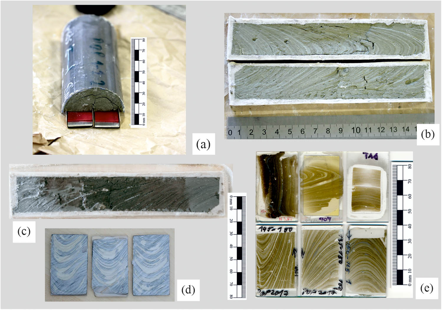
Steps and results of gypsum method: (a) subsamplers pushed lengthwise into the wet sample; (b) subsamples embedded with gypsum; the cracks in the middle formed before cutting and embedding; (c) impregnated and un-polished subsample slab; (d) subsamples after the first epoxy resin impregnation showing the penetration depth; light places still non-impregnated; (e) polished thin-sections prepared from unconsolidated laminated sediments from Tatra Mts. lakes.
4.2 Dehydration
Subsample dehydration process is an important step for the preparation of thin-section and to achieve sediment without cracks and the deformed surface is very crucial. Various dehydration methods have been developed through time and have different properties (Table 2): freeze-drying [10,17,20,21], acetone in the liquid phase [13,21,22,23,24], and critical point drying [17,25]. Repeated exchanges of acetone [13] are a time-consuming procedure and require a large quantity of solvent [14]. Our first attempt to produce the thin sections followed the acetone method [13], but it caused the large cracks in the laminae and the samples were unusable. So to avoid such cracks, we adopted a process of the subsample stabilization using the ordinary gypsum, which took about 1 h to harden (Figure 5b). We tested the gypsum of two different producers. To obtain the semiliquid consistency, we followed the producer instructions and the gypsum with longer time of hardening was more suitable for work. The gypsum embedding keeps the sediment partially moist, and later, the Epoxy resin impregnation [13] could be carried out. The dry gypsum embedded subsample can be used to produce acetate peels. In the gypsum procedure, the crack formation in sediment is remarkably reduced and the time for dehydration can be reduced. To minimize the crack formation, the paper label is left on the fresh sediment surface which acts as “patch” against cracking, prevents the sample surface from quick drying and holds the sediment during the drying (Figure 3g and h).
Methods of dehydration of the unconsolidated limnic sediment and their advantages and disadvantages from various practices
| Method | Advantages | Disadvantages | Source |
|---|---|---|---|
| Freeze-drying | Fast and low recurring costs; minimal cracks | Cracks in sediments with high contents of organic matter | [10,17,20,21] |
| Acetone in liquid phase | Gentle dehydration; rare cracks; high quality samples | Collapsing of coarse sediments; expensive due to acetone consumption; time consuming (7–10 days) | [13,21,22,23,24] |
| Critical point drying | Gentle dehydration; minimal cracks | Changes in the physical properties of pore solutions; possible damage due to fluid movements | [17,25] |
| Gypsum embedding | Gentle dehydration; easy manipulation with soft and fresh sediment rare cracks; fast curing time; suitable for acetate peel replicas | This article |
4.3 Impregnation
The use of polymers in impregnation of the unconsolidated deposit is a standard practice, and each polymer has its own properties (Table 3). Our laboratory has the best experiences with the Epoxy 2000 resin for the preparation of the petrological and paleontological thin sections, and we used this resin for impregnating the laminated deposits. To gain the total impregnation, an embedded subsample is left in the highest possible vacuum; in our case, the vacuum chamber reaches pressure conditions −0.8 bar. The vacuum condition produces a slower flux in resin and saturates the porous sediment due to the capillarity of the sediment and the low viscosity resin embeds the unconsolidated sediment [13]. The embedding box can be reused for next sample.
Methods of embedding and advantages and disadvantages discussed from various practices
| Embedding material | Catalyst | Advantages | Disadvantages | Source |
|---|---|---|---|---|
| Spurr low-viscosity resin | Dimethylaminoethanol | Can be performed without special equipment; easily adaptable in laboratory | Hydrophobic; suspected to be carcinogenic; toxic; suspected to provoke allergic reactions | [10,13,22,26] |
| Araldite | Accelerator 964 C DMP-30 | Moderate costs; fast hardening | Suspected to be carcinogenic; suspected to provoke allergic reactions; requires a great deal of work; embedding in a desiccator with low pressure; requires freeze-drying | [10,27] |
| Palatal | Cyclo hexanon peroxide | Good quality; applicable to dry sample; can easily be thinned with acetone and the curing time is long enough to allow complete impregnation | Suspected to be carcinogenic; prolonged ‘floating’ of the sediment over palatal; slow, requires at least 2 weeks; requires dehydration by acetone | [28] |
| Castolite resin | Oxydation | Undisturbed soil samples; low viscous for easy penetration | — | [29] |
| Methyl methacrylate | Benzoyl peroxide | Suitable for the embedding of porous material | Lack of autopolymerisation | [30] |
| Crystic | Andonox® KP9; Norox® MEKP-925H | Requires a minimum of equipment | Needs thinning with acetone | [21] |
| LR white hard resin | Benzoyl peroxide | Extremely low viscosity; low vapour pressure; low toxicity | Distortion and wraping occurs on curing; anaerobic polymerization is advised for curing | [31] |
| Epoxy 2000 resin | Epoxy 2000 hardener | Fast hardening; can be performed without special equipment; easy preparation; curing at room temperature, low water content within the sediment does not influence the hardening process | Microbubbles and microcracks; suspected to be carcinogenic; toxic; suspected to provoke allergic reactions | This article |
When impregnating the unconsolidated laminated deposit, the resin penetrates the sample only 2 mm from the surface (Figure 5d), but the depth of impregnation depends on porosity and sediment material composition (resin goes deeply in gyttja). Therefore, during the lapping of the surface before gluing the sample to glass slide, we have to repeat the impregnation 1–2 times accompanied by gentle lapping to preserve sedimentary structures of the impregnated subsample.
4.4 Polymerization
Embedded subsample is left to cure under room temperature, which is easy but little time-consuming whereas there are other methods work with higher temperatures [13] that could lead to bubbles development in the resin. This process requires the maximum time of 24–36 h, depending on the amount of polymer used to impregnate the sediment.
The impregnated sediment (Figure 5c) is diagonally cut into standard 2.5 × 4.5 cm slabs (Figures 5d, e, and 6), but also larger thin-sections could be produced (it depends on the laboratory equipment). For grinding of the surface before gluing, we use the SiC powder of the grain sizes F320, F600, F800, and for the finishing SiC powder F800, F1200. For final polishing, we use the water-based 1-micron polycrystalline diamond suspension. Thin-sections prepared by this method can be used for elemental analysis using micro-XRF (Figure 7) and X-radiographic images [10,17,32] to study the paleoclimate and seasonal indicators in these laminated deposits.

Thin-sections prepared by the gypsum method under an optical microscope (a–d) and SEM (e). (a and b) Popradské pleso; (c–e) Batizovské pleso. Small black dots (b–d) looking as preserved organic matter or residual grinding powder were studied under UV light, Raman spectroscopy, and light microscopy. These are micro-bubbles and micro-cracks.

Distribution of the elements in the (a) laminated deposits from Popradské pleso prepared by the gypsum method and analyzed (b–f) by micro-XRF and (g) in the optic-microscope. Thin sections from Figure 5e, right down.
5 Conclusion
Gypsum can effectively help in dehydration and stabilization of the fine-laminated clastic deposit. The gypsum embedding keeps the sediment partially moist, and the sample is ready for impregnation with resin. After impregnation, the slab of 10 × 2.5 cm is prepared for elemental mapping on micro-XRF, X-radiographic, image analysis, or production of the thin sections. The method needs a minimal infrastructure and makes the entire process of preparation of polished thin sections faster and can be done within 3 to 4 days. The gypsum dehydration was performed on laminated clastic deposits and its use on biochemical- and organic-rich laminated sediment should be tested.
Acknowledgments
This work was financially supported by the project APVV-15-0292 and by the projects: Centre of Excellence for Integrated Research of the Earth’s Geosphere (ITMS: 26220120064) and Completion of technical infrastructure for research of geodynamical processes and global changes in Earth’s history (ITMS: 26210120013), which had been co-financed through the European Regional Development Fund.
Author contributions: Ramachandran Dhavamani – Co-operation in the process of preparation of the thin-sections and study of the laminated deposits. Golej Marián – Preparation of the polished thin-sections, technical support. He proposed the gypsum for the dehydration process and the Epoxy 2000 resin for impregnation process. Starek Dušan – Expertise in sedimentology and microscopic studies of the clastic deposits. Pipík Radovan – supervising the technical work, project leader.
References
[1] Ojala AEK, Saarinen T, Salonen VP. Preconditions for the formation of annually laminated lake sediments in Southern and central Finland. Boreal Env Res. 2000;5:243–55.Search in Google Scholar
[2] Brauer A. Annually laminated lake sediments and their palaeoclimatic relevance. In: Fischer H, Kumke Th, Lohmann G, Miller H, Negendank J, editors. The Climate in historical times. GKSS School of Environmental Research. Berlin, Heidelberg: Springer; 2004. p. 109–27. 10.1007/978-3-662-10313-5_7.Search in Google Scholar
[3] Brauer A, Dulski P, Mangili C, Mingram J, Liu J. The potential of varves in high-resolution, paleolimnological studies. Pages News. 2009;17(3):96–8. 10.22498/pages.17.3.96.Search in Google Scholar
[4] Zolitschka B, Francus P, Ojala AEK, Schimmelmann A. Varves in lake sediments – a review. Quat Sci Rev. 2015;117:1–41. 10.1016/j.quascirev.2015.03.019.Search in Google Scholar
[5] Bendle JM, Palmer AP, Carr SJ. A comparison of micro-CT and thin section analysis of Lateglacial glaciolacustrine varves from Glen Roy, Scotland. Quat Sci Rev. 2015;114:61–77. 10.1016/j.quascirev.2015.02.008.Search in Google Scholar
[6] Palmer AP, Bendle J, Macleod A, Rose J, Thorndycraft V. The micromorphology of glaciolacustrine varve sediments and their use for reconstructing palaeoglaciological and palaeoenvironmental change. Quat Sci Rev. 2019;226:105964. 10.1016/j.quascirev.2019.105964.Search in Google Scholar
[7] National Petrographic Service, Inc. http://www.nationalpetrographic.com/different-types-of-thin-sections, 2020.Search in Google Scholar
[8] Lamoureux SF. Varve chronology techniques. In: Last WM, Smol JP, editors. Tracking environmental change using lake sediments. Basin analysis, and chronological techniques. vol. 1, Dordrecht: Kluwer Academic Publishers; 2001. p. 247–60. 10.1007/0-306-47669-X_11.Search in Google Scholar
[9] Ojala AEK, Francus P, Zolitschka B, Besonen M, Lamoureux SF. Characteristics of sedimentary varve chronologies – A review. Quat Sci Rev. 2012;43:45–60. 10.1016/j.quascirev.2012.04.006.Search in Google Scholar
[10] Francus P. Annually resolved grain-size distributions in varved sediments using image analysis – application to Paleoclimatology. Sediment Geol. 1998;121(3):289–98. 10.1016/S0037-0738(98)00078-5.Search in Google Scholar
[11] Lapointe F, Francus P, Lamoureux SF, Saïd M, Cuven S. years of large rainfall events inferred from particle size at East Lake, Cape Bounty, Melville Island, Canada. J Paleolimnol 2012. 1750;48(1):159–73. 10.1007/s10933-012-9611-8.Search in Google Scholar
[12] Renberg I. Improved methods for sampling, photographing and varve counting of varved lake sediments. Boreas. 1981b;10:255–8. 10.1111/j.1502-3885.1981.tb00486.x.Search in Google Scholar
[13] Lamoureux SF. Embedding unfrozen lake sediments for thin section preparation. J Paleolimnol. 1994;10:141–6. 10.1007/BF00682510.Search in Google Scholar
[14] Boës X, Fagel N. Impregnation method for detecting annual laminations in sediment cores: An overview. Sediment Geol. 2005;179:185–94. 10.1016/j.sedgeo.2005.05.001.Search in Google Scholar
[15] Normandeau A, Brown O, Jarrett K, Francus P, De Coninck A. Epoxy impregnation of unconsolidated marine sediment core subsamples for the preparation of thin sections at the Geological Survey of Canada (Atlantic). Geol, Surv Canada, Tech Note. 2019;10:1–10. 10.4095/313055.Search in Google Scholar
[16] Ludlam SD. Sedimentation rates in Fayetteville Green Lake, New York, USA. Sedimentology. 1981;28:85–96. 10.1111/j.1365-3091.1981.tb01665.x.Search in Google Scholar
[17] Pike J, Kemp AES. Preparation and analysis techniques for studies of laminated sediments. In: Kemp AES, editor. Palaeoclimatology and Palaeoceanography from Laminated Sediments. Geol. Soc., London, Spec. Publ.; 1996:116. p. 37–48. 101144/GSL.SP.19961160105.Search in Google Scholar
[18] Francus P, Asikainen CA. Sub-sampling unconsolidated sediments: a solution for the preparation of undisturbed thin-sections from clay-rich sediments. J Paleolimnol. 2001;26(3):323–6. 10.1023/A:1017572602692.Search in Google Scholar
[19] Nakagawa T. Suigetsu 2006 project Members. High-precision sampling of laminated sediments: Strategies from Lake Suigetsu. Pages Mag. 2014;22(1):12–3. 10.22498/pages.22.1.12.Search in Google Scholar
[20] Murphy CP. Thin-section preparation of soils and sediments. Soil Sci. 1986;144(4):307–8. 10.1097/00010694-198710000-00013.Search in Google Scholar
[21] Conway JS. A simplified method for impregnation of soils and similar clay-rich sediments. J Sediment Pet. 1982;52:650–1.10.1306/212F7FD6-2B24-11D7-8648000102C1865DSearch in Google Scholar
[22] Clark JS. Stratigraphic charcoal analysis on petrographic thin sections: application to fire history in Northwestern Minnesota. Quat Res. 1988;30:81–91. 10.1016/0033-5894(88)90089-0.Search in Google Scholar
[23] Lamoureux SF. Catchment and lake controls over the formation of varves in monomictic Nicolay Lake, Cornwall Island, Nunavut. Can J Earth Sci. 1999;36(9):1533–46. 10.1139/e99-040.Search in Google Scholar
[24] Lotter AF, Lemcke G. Methods for preparing and counting biochemical varves. Boreas. 1999;28:243–52. 10.1111/j.1502-3885.1999.tb00218.x.Search in Google Scholar
[25] Bouma AH. Method for the study of sedimentary structures. New York: Wiley and Sons; 1969.Search in Google Scholar
[26] Kemp AES, Dean J, Pearce RB, Pike J. Recognition and analysis of bedding and sediment fabric features. In: Last WM, Smol JP, editors. Tracking environmental change using lake sediments. Developments in Paleoenvironmental Research. vol 2, Dordrecht: Springer; 2001. p. 7–22. 10.1007/0-306-47670-3_2.Search in Google Scholar
[27] Zolitschka B. Image analysis and microscopic investigation of annually laminated lake sediments from Fayetteville Green Lake (NY, USA) Lake C2 (NWT, Canada) and Holzmaar (Germany): A comparison. Geol Soc London, Spec Publ. 1996;116(1):49–55. 10.1144/GSL.SP.1996.116.01.06.Search in Google Scholar
[28] Röhrig R, Scharf BW. An alternative embedding method for thin section preparation of lake sediments. J Paleolimnol. 2006;35:207–9. 10.1007/s10933-005-2316-5.Search in Google Scholar
[29] Bourbeau GA, Berger KC. Thin sections of soils and friable materials prepared by impregnation with the plastic “Castolite”. Soil Sci Soc Am Proc. 1947;12:409–12. 10.2136/sssaj1948.036159950012000C0092x.Search in Google Scholar
[30] Palle SD, Chappard C, Orsini JB. Friable rock embedding in methyl methacrylate for thin-sectioning in geological preparations. J Microbiol. 1985;141:193–8. 10.1111/j.1365-2818.1986.tb02715.x.Search in Google Scholar
[31] Ferrow E, Roots W. A preparation technique for TEM specimens, application to synthetic Mg-chlorite. Eur J Miner. 1989;1:815–9.10.1127/ejm/1/6/0815Search in Google Scholar
[32] Dulski P, Brauer A, Mangili C. Combined μ-XRF and microfacies techniques for lake sediment analyses. In: Croudace IW, Rothwell RG, editors. Micro-XRF Studies of Sediment Cores. Dordrecht: Springer; 2015. p. 325–49. 10.1007/978-94-017-9849-5_12.Search in Google Scholar
© 2020 Ramachandran Dhavamani et al., published by De Gruyter
This work is licensed under the Creative Commons Attribution 4.0 International License.
Articles in the same Issue
- Regular Articles
- The simulation approach to the interpretation of archival aerial photographs
- The application of137Cs and210Pbexmethods in soil erosion research of Titel loess plateau, Vojvodina, Northern Serbia
- Provenance and tectonic significance of the Zhongwunongshan Group from the Zhongwunongshan Structural Belt in China: insights from zircon geochronology
- Analysis, Assessment and Early Warning of Mudflow Disasters along the Shigatse Section of the China–Nepal Highway
- Sedimentary succession and recognition marks of lacustrine gravel beach-bars, a case study from the Qinghai Lake, China
- Predicting small water courses’ physico-chemical status from watershed characteristics with two multivariate statistical methods
- An Overview of the Carbonatites from the Indian Subcontinent
- A new statistical approach to the geochemical systematics of Italian alkaline igneous rocks
- The significance of karst areas in European national parks and geoparks
- Geochronology, trace elements and Hf isotopic geochemistry of zircons from Swat orthogneisses, Northern Pakistan
- Regional-scale drought monitor using synthesized index based on remote sensing in northeast China
- Application of combined electrical resistivity tomography and seismic reflection method to explore hidden active faults in Pingwu, Sichuan, China
- Impact of interpolation techniques on the accuracy of large-scale digital elevation model
- Natural and human-induced factors controlling the phreatic groundwater geochemistry of the Longgang River basin, South China
- Land use/land cover assessment as related to soil and irrigation water salinity over an oasis in arid environment
- Effect of tillage, slope, and rainfall on soil surface microtopography quantified by geostatistical and fractal indices during sheet erosion
- Validation of the number of tie vectors in post-processing using the method of frequency in a centric cube
- An integrated petrophysical-based wedge modeling and thin bed AVO analysis for improved reservoir characterization of Zhujiang Formation, Huizhou sub-basin, China: A case study
- A grain size auto-classification of Baikouquan Formation, Mahu Depression, Junggar Basin, China
- Dynamics of mid-channel bars in the Middle Vistula River in response to ferry crossing abutment construction
- Estimation of permeability and saturation based on imaginary component of complex resistivity spectra: A laboratory study
- Distribution characteristics of typical geological relics in the Western Sichuan Plateau
- Inconsistency distribution patterns of different remote sensing land-cover data from the perspective of ecological zoning
- A new methodological approach (QEMSCAN®) in the mineralogical study of Polish loess: Guidelines for further research
- Displacement and deformation study of engineering structures with the use of modern laser technologies
- Virtual resolution enhancement: A new enhancement tool for seismic data
- Aeromagnetic mapping of fault architecture along Lagos–Ore axis, southwestern Nigeria
- Deformation and failure mechanism of full seam chamber with extra-large section and its control technology
- Plastic failure zone characteristics and stability control technology of roadway in the fault area under non-uniformly high geostress: A case study from Yuandian Coal Mine in Northern Anhui Province, China
- Comparison of swarm intelligence algorithms for optimized band selection of hyperspectral remote sensing image
- Soil carbon stock and nutrient characteristics of Senna siamea grove in the semi-deciduous forest zone of Ghana
- Carbonatites from the Southern Brazilian platform: I
- Seismicity, focal mechanism, and stress tensor analysis of the Simav region, western Turkey
- Application of simulated annealing algorithm for 3D coordinate transformation problem solution
- Application of the terrestrial laser scanner in the monitoring of earth structures
- The Cretaceous igneous rocks in southeastern Guangxi and their implication for tectonic environment in southwestern South China Block
- Pore-scale gas–water flow in rock: Visualization experiment and simulation
- Assessment of surface parameters of VDW foundation piles using geodetic measurement techniques
- Spatial distribution and risk assessment of toxic metals in agricultural soils from endemic nasopharyngeal carcinoma region in South China
- An ABC-optimized fuzzy ELECTRE approach for assessing petroleum potential at the petroleum system level
- Microscopic mechanism of sandstone hydration in Yungang Grottoes, China
- Importance of traditional landscapes in Slovenia for conservation of endangered butterfly
- Landscape pattern and economic factors’ effect on prediction accuracy of cellular automata-Markov chain model on county scale
- The influence of river training on the location of erosion and accumulation zones (Kłodzko County, South West Poland)
- Multi-temporal survey of diaphragm wall with terrestrial laser scanning method
- Functionality and reliability of horizontal control net (Poland)
- Strata behavior and control strategy of backfilling collaborate with caving fully-mechanized mining
- The use of classical methods and neural networks in deformation studies of hydrotechnical objects
- Ice-crevasse sedimentation in the eastern part of the Głubczyce Plateau (S Poland) during the final stage of the Drenthian Glaciation
- Structure of end moraines and dynamics of the recession phase of the Warta Stadial ice sheet, Kłodawa Upland, Central Poland
- Mineralogy, mineral chemistry and thermobarometry of post-mineralization dykes of the Sungun Cu–Mo porphyry deposit (Northwest Iran)
- Main problems of the research on the Palaeolithic of Halych-Dnister region (Ukraine)
- Application of isometric transformation and robust estimation to compare the measurement results of steel pipe spools
- Hybrid machine learning hydrological model for flood forecast purpose
- Rainfall thresholds of shallow landslides in Wuyuan County of Jiangxi Province, China
- Dynamic simulation for the process of mining subsidence based on cellular automata model
- Developing large-scale international ecological networks based on least-cost path analysis – a case study of Altai mountains
- Seismic characteristics of polygonal fault systems in the Great South Basin, New Zealand
- New approach of clustering of late Pleni-Weichselian loess deposits (L1LL1) in Poland
- Implementation of virtual reference points in registering scanning images of tall structures
- Constraints of nonseismic geophysical data on the deep geological structure of the Benxi iron-ore district, Liaoning, China
- Mechanical analysis of basic roof fracture mechanism and feature in coal mining with partial gangue backfilling
- The violent ground motion before the Jiuzhaigou earthquake Ms7.0
- Landslide site delineation from geometric signatures derived with the Hilbert–Huang transform for cases in Southern Taiwan
- Hydrological process simulation in Manas River Basin using CMADS
- LA-ICP-MS U–Pb ages of detrital zircons from Middle Jurassic sedimentary rocks in southwestern Fujian: Sedimentary provenance and its geological significance
- Analysis of pore throat characteristics of tight sandstone reservoirs
- Effects of igneous intrusions on source rock in the early diagenetic stage: A case study on Beipiao Formation in Jinyang Basin, Northeast China
- Applying floodplain geomorphology to flood management (The Lower Vistula River upstream from Plock, Poland)
- Effect of photogrammetric RPAS flight parameters on plani-altimetric accuracy of DTM
- Morphodynamic conditions of heavy metal concentration in deposits of the Vistula River valley near Kępa Gostecka (central Poland)
- Accuracy and functional assessment of an original low-cost fibre-based inclinometer designed for structural monitoring
- The impacts of diagenetic facies on reservoir quality in tight sandstones
- Application of electrical resistivity imaging to detection of hidden geological structures in a single roadway
- Comparison between electrical resistivity tomography and tunnel seismic prediction 303 methods for detecting the water zone ahead of the tunnel face: A case study
- The genesis model of carbonate cementation in the tight oil reservoir: A case of Chang 6 oil layers of the Upper Triassic Yanchang Formation in the western Jiyuan area, Ordos Basin, China
- Disintegration characteristics in granite residual soil and their relationship with the collapsing gully in South China
- Analysis of surface deformation and driving forces in Lanzhou
- Geochemical characteristics of produced water from coalbed methane wells and its influence on productivity in Laochang Coalfield, China
- A combination of genetic inversion and seismic frequency attributes to delineate reservoir targets in offshore northern Orange Basin, South Africa
- Explore the application of high-resolution nighttime light remote sensing images in nighttime marine ship detection: A case study of LJ1-01 data
- DTM-based analysis of the spatial distribution of topolineaments
- Spatiotemporal variation and climatic response of water level of major lakes in China, Mongolia, and Russia
- The Cretaceous stratigraphy, Songliao Basin, Northeast China: Constrains from drillings and geophysics
- Canal of St. Bartholomew in Seča/Sezza: Social construction of the seascape
- A modelling resin material and its application in rock-failure study: Samples with two 3D internal fracture surfaces
- Utilization of marble piece wastes as base materials
- Slope stability evaluation using backpropagation neural networks and multivariate adaptive regression splines
- Rigidity of “Warsaw clay” from the Poznań Formation determined by in situ tests
- Numerical simulation for the effects of waves and grain size on deltaic processes and morphologies
- Impact of tourism activities on water pollution in the West Lake Basin (Hangzhou, China)
- Fracture characteristics from outcrops and its meaning to gas accumulation in the Jiyuan Basin, Henan Province, China
- Impact evaluation and driving type identification of human factors on rural human settlement environment: Taking Gansu Province, China as an example
- Identification of the spatial distributions, pollution levels, sources, and health risk of heavy metals in surface dusts from Korla, NW China
- Petrography and geochemistry of clastic sedimentary rocks as evidence for the provenance of the Jurassic stratum in the Daqingshan area
- Super-resolution reconstruction of a digital elevation model based on a deep residual network
- Seismic prediction of lithofacies heterogeneity in paleogene hetaoyuan shale play, Biyang depression, China
- Cultural landscape of the Gorica Hills in the nineteenth century: Franciscean land cadastre reports as the source for clarification of the classification of cultivable land types
- Analysis and prediction of LUCC change in Huang-Huai-Hai river basin
- Hydrochemical differences between river water and groundwater in Suzhou, Northern Anhui Province, China
- The relationship between heat flow and seismicity in global tectonically active zones
- Modeling of Landslide susceptibility in a part of Abay Basin, northwestern Ethiopia
- M-GAM method in function of tourism potential assessment: Case study of the Sokobanja basin in eastern Serbia
- Dehydration and stabilization of unconsolidated laminated lake sediments using gypsum for the preparation of thin sections
- Agriculture and land use in the North of Russia: Case study of Karelia and Yakutia
- Textural characteristics, mode of transportation and depositional environment of the Cretaceous sandstone in the Bredasdorp Basin, off the south coast of South Africa: Evidence from grain size analysis
- One-dimensional constrained inversion study of TEM and application in coal goafs’ detection
- The spatial distribution of retail outlets in Urumqi: The application of points of interest
- Aptian–Albian deposits of the Ait Ourir basin (High Atlas, Morocco): New additional data on their paleoenvironment, sedimentology, and palaeogeography
- Traditional agricultural landscapes in Uskopaljska valley (Bosnia and Herzegovina)
- A detection method for reservoir waterbodies vector data based on EGADS
- Modelling and mapping of the COVID-19 trajectory and pandemic paths at global scale: A geographer’s perspective
- Effect of organic maturity on shale gas genesis and pores development: A case study on marine shale in the upper Yangtze region, South China
- Gravel roundness quantitative analysis for sedimentary microfacies of fan delta deposition, Baikouquan Formation, Mahu Depression, Northwestern China
- Features of terraces and the incision rate along the lower reaches of the Yarlung Zangbo River east of Namche Barwa: Constraints on tectonic uplift
- Application of laser scanning technology for structure gauge measurement
- Calibration of the depth invariant algorithm to monitor the tidal action of Rabigh City at the Red Sea Coast, Saudi Arabia
- Evolution of the Bystrzyca River valley during Middle Pleistocene Interglacial (Sudetic Foreland, south-western Poland)
- A 3D numerical analysis of the compaction effects on the behavior of panel-type MSE walls
- Landscape dynamics at borderlands: analysing land use changes from Southern Slovenia
- Effects of oil viscosity on waterflooding: A case study of high water-cut sandstone oilfield in Kazakhstan
- Special Issue: Alkaline-Carbonatitic magmatism
- Carbonatites from the southern Brazilian Platform: A review. II: Isotopic evidences
- Review Article
- Technology and innovation: Changing concept of rural tourism – A systematic review