Impact evaluation and driving type identification of human factors on rural human settlement environment: Taking Gansu Province, China as an example
-
Haojian Dou
 ,
Huan Li
,
Huan Li

Abstract
Evaluating the quality of rural human (RH) settlements and clarifying its spatial differentiation characteristics have the most direct guiding role for the formulation of regional construction policies and the optimization of RH settlements. In this study, the index model of environmental quality of RH settlement was established. ImPACT and trade-off analysis methods were used to quantitatively identify the spatial differentiation of RH settlement and dominant impact human factors of it in Gansu Province in 2017. Then, the driving type of RH settlement environment was identified. Results are as follows. (1) The overall environmental quality of RH settlement in Gansu Province shows a decreasing trend from “west to east.” (2) The environmental quality of RH settlement is mainly affected by eight factors, of which the effect of quantity index per capita is more significant. (3) The trade-off relationship between the environmental quality index and these eight dominant factors is mainly low–low, which indicates that the human factors are the main reason for the environmental quality of the RH settlement. (4) Based on the dominant human factors, Gansu Province is classified into four driving types, of which the proportion of comprehensive type accounts for 77.01%.
1 Introduction
The rural human (RH) settlement environment refers to the environment related to living, residence, and basic production activities of rural residents. It is a combination of materials and non-materials required for production and living of residents in rural areas [1]. It includes both hard environment, such as living conditions, infrastructure, and public service facilities, and soft environment, such as living comfort level, convenience of information exchange, level of economic development, and level of social services. In the 1950s, Doxiadis, Greek urban planner, put forward the research concept of “Human settlement.” He believed that human settlement is the basis of human survival and development, the geographic space of closest and most specific material exchange, as well as emotional communication between human and environment [2,3]. In the early 1990s, Chinese scholar Liangyong Wu first advocated the establishment of “human settlement environment science.” The human settlement environment is a place where humans live together, consisting of five systems such as natural system, human system, social system, residential system, and supporting system [4]. In addition, it is a multi-level and multi-type spatial system and can be classified into urban human settlement environment and RH settlement environment [5].
With the acceleration of urbanization, the issue of urban human settlement environment in the development of European and American cities has attracted much attention, and related research results have increased [6]. Human settlement environment research shows a strong “urbanism” tendency [7]. In this case, the development of the countryside has been neglected. The problems, such as rural poverty, disorderly development of rural settlement space, severe destruction of rural ecological landscape, and gradual decline of rural traditional culture, have emerged [3]. In terms of research progress on the human settlement environment, foreign scholars pay more attention to the expansion and in-depth evaluation of the content, incorporating factors such as gender, low-income groups, environmental sanitation, health, transportation, natural disasters, and environmental goals into the human settlement environment quality assessment system. Domestic scholars have carried out research from both macro- and micro-levels [8,9]. At the macro-level of the country, region, and watershed, they mainly study the geographical theoretical system of rural settlements, the spatial pattern of rural settlements, the evolution and sustainable development of RH settlements, and the quantitative assessment of human settlements and its impact factors. At the village level and other micro-levels, they mainly study through interviews and questionnaire surveys of rural households to explore the micro-mechanism and path selection of human settlement environment construction [10,11]. In addition, with the intensification of the flow of urban and rural elements, rural subjects have obtained a broader space for behavior. The diversified behavior results in the transformation and expansion of the “factor-structure-function” of the rural spatial system [11]. The reconstruction of RH settlement environment has been the focus of this research. In the process, many contradictions and conflicts between rural economic development and environmental protection of RH settlements have arisen [12,13]. Researchers should carry out the study of RH settlement environment from the perspective of spatial heterogeneity, analyze the impact of social and human factors on the RH settlement environment, and reveal the driving types of RH settlement environment. This has the most direct guiding impact on the formulation of construction policies of regional RH settlement environment and the optimization of RH settlement environment in accordance with local conditions.
Gansu Province is an underdeveloped region in western China, whose ecology is sensitive and fragile. Its long-term urban–rural dual structure system has led to problems such as scattered rural housing layout, backward infrastructure, and fragile ecological environment because of the vast area that is affected by the natural environment and society. Influenced by multiple factors such as economic and cultural differences of Gansu Province, the RH settlement environment shows significant spatial heterogeneity, and its development reflects the development and evolution of human–land interaction. The RH settlement environment is the result of the interaction of a variety of human factors. To systematically and comprehensively analyze the spatial differences and influencing factors of the regional human settlement environment, the selection of indicators and models is particularly important. Factors such as topography, hydrology, climate, and vegetation are the natural basis for human survival. The long-term accumulation in the process of rural development plays a relatively stable role in the quality of human settlements, determining the original distribution of the population, economics, social, and production. The human element is the product of human activities, directly related to the movement of the population in the geographical space, and has a significant impact on the quality of the human settlement environment. At present, most of the scholars focus on studying the impact of natural factors on the human settlement environment, whereas human factors are rarely involved [14,15]. Based on this, Gansu Province is taken as an example in this study to construct a comprehensive evaluation index system for RH settlement environment quality, clarify the current level of RH settlement environment quality and spatial differentiation characteristics, reveal the impact of human factors on the RH settlement environment, and identify the driving types of RH settlements, to provide decision-making basis and experience reference for the renovation and optimization of RH settlements.
2 The overview of research region
2.1 Natural geographical environment
Gansu is located in the inland of western China, between 92°13′ E and 108°46′ E as well as between 32°31′N and 42°57′ N. It is also located in the intersection of the northwest arid region, the Qinghai-Tibet alpine region, and the eastern monsoon region. The total area of the province is 42.58 × 10⁴ km2, accounting for 4.72% of China’s total land area. The landforms are complex and diverse. Mountains, plateaus, plains, river valleys, deserts, and Gobi have staggered distribution. The terrain tilts from southwest to northeast. The altitude of most of the Gansu Province is above 1,000 m. The area of mountains and plateaus accounts for about 70% of the total land area of Gansu Province. Gansu is situated deeply inland. The warm and humid air currents from oceans are difficult to reach this region. It is difficult to form precipitation and the climate in most areas is dry. It has the continental temperate monsoon climate. The annual average temperature is 0–15°C, and the annual precipitation is 36.6–734.9 mm, declining from southeast to northwest. Precipitation mostly concentrates in June to August, accounting for 50–70% of the total annual precipitation. The difference in frost-free period among regions of Gansu Province is significant. The frost-free period of Longnan River Valley is around 280 days, and that of the Gannan Plateau is the shortest with only 140 days. The rivers in Gansu belong to the three major river basins of the Yangtze River, the Yellow River, and the inland rivers, with both internal and external river basins. Area of each river basin accounts for 8%, 32%, and 60% of the total river area, respectively. The Gansu Province is covered by forests, thickets, grasslands, and deserts. There are many plant-cover types, such as meadow, pad-like vegetation, sparse vegetation on the slopes of high mountain debris, and swamps and aquatic vegetation. The plant resources are rich [16] (Figure 1).

Location of Gansu Province.
2.2 Socioeconomic environment
Gansu Province has jurisdiction over 14 cities (or prefectures) and 87 counties (or districts). At the end of 2018, the total population of Gansu Province was 2,63,26,000. The rural population was about 1,37,95,550, and the urbanization rate reached 47.69%. The per capita annual net income of rural households was 8804.1 Yuan, and the Engel coefficient of rural residents was 29.7%. Since the government of Gansu Province released the “Action Plan on Improving the Rural Human Settlement Environment” in 2014, a series of policies and systems had been explored to improve people’s livelihood and promote the equalization of basic public services in urban and rural areas. Many practices, such as dilapidated housing renewal, drinking water safety, and road hardening, have initially improved the RH settlement environment. In 2018, to further strengthen the governance of RH settlement environment, Gansu Province issued the “Implementation of the Three-Year Action on Improvement of Rural Human Settlement Environment.” This further improves the RH settlement environment, creating the tidy and orderly rural environment and increasing the environmental and health awareness of rural residents. At the end of 2018, the proportions of rural regions with hardened roads, tap water, and village bus in Gansu Province accounted for 96.7%, 86%, and 95.6%, respectively. The green coverage rate in rural regions reached 16.3%. The proportion of rural household garbage dispose is 45% and that of access to sanitary toilets in rural areas is 20%. The comprehensive utilization rate of livestock and poultry manure was 70%. A total of 97.5% rural regions had the comprehensive cultural service centers, and 85% rural regions had the planning management [16].
3 Data sources and research methods
3.1 Data source
The data used in this study come from three sources. (1) Basic maps: topographic map (1:2,50,000) and vector administrative boundary (1:2,50,000) for Gansu Province were obtained from Gansu Province Surveying and Mapping Bureau. (2) Basic data about population, income, and expenditure, living conditions and culture, infrastructure, public services, etc. for Gansu Province in 2017, from Gansu Province Development Yearbook 2018, Gansu Province Rural Areas Yearbook 2018, China Statistical Yearbook 2018, China Rural Areas Yearbook 2018, etc. [17,18,19,20]. (3) The cultivated land area and construction land area for each county (district) of Gansu Province in 2017 from survey data of land-use change in Gansu Province.
During the impact evaluation of RH settlement environment at the country level in Gansu Province, the initial data were standardized to eliminate the influence of dimension and numerical size on the results [21]. If a greater value is more conducive to system development, then the index is positive, and equation (1) will be used for its standardization. If a lesser value is more conducive to system development, then the index is negative, and equation (2) will be used for its standardization. The equations are as follows:
For positive index:
and for negative index:
where Ci and Zi are the initial and standardized values of ith index of each county in Gansu Province in 2017, respectively, and max(Ci) and min(Ci) are the maximum and minimum values of ith index, respectively.
In addition, to minimize the influence of subjective factors on evaluation results in the process of determining the weights, coefficient of variation was used to objectively assign weight to each index. The procedures are as follows:
where δi, Di,
Evaluation index system of RH settlement environment in Gansu Province and weights of indices
| Target layer | Criterion layer | Evaluation index layer | Index weight | Positive or negative |
|---|---|---|---|---|
| Quality of RH settlement environment | Production and living environment, B1 (0.2381) | Agricultural mechanization rate, Z11 (%) | 0.1136 | + |
| Agricultural technology popularization rate, Z12 (%) | 0.4006 | + | ||
| Electricity consumption per 10,000 households, Z13 (kWh) | 0.2755 | + | ||
| Per capita housing area of rural residents, Z14 (m2/person) | 0.2103 | + | ||
| Infrastructure environment, B2 (0.1570) | Tap water usage in rural areas, Z21 (%) | 0.1508 | + | |
| Access rate of public transportation lines in rural areas, Z22 (%) | 0.2815 | + | ||
| Rural broadband coverage, Z23 (%) | 0.2408 | + | ||
| Rural cable television popularization rate, Z24 (%) | 0.3269 | + | ||
| Public service facilities environment, B3 (0.2122) | The number of teachers per 1,000 people, Z31 (person) | 0.2251 | + | |
| Rate of participation in new rural cooperative medical system, Z32 (%) | 0.0830 | + | ||
| Number of hospital beds per 1,000 people, Z33 (units) | 0.3200 | + | ||
| Proportion of health care expenditure in household consumption expenditure, Z34 (%) | 0.3720 | + | ||
| Ecological environment, B4 (0.3928) | Rate of centralized treatment of rural domestic garbage, Z41 (%) | 0.2381 | + | |
| Rate of centralized treatment of sewage, Z42 (%) | 0.6006 | + | ||
| Forest coverage, Z43 (%) | 0.1613 | + |
3.2 Research methods
3.2.1 The evaluation method of RH settlement environment
3.2.1.1 The establishment of evaluation index system of RH settlement environment
Establishing a comprehensive and effective evaluation index system is the key to accurately evaluate and quantify RH settlement environment in the 87 evaluation units of Gansu Province. The RH settlement environment is a complex system, consisting of multi-attribute and multi-level subsystems. To evaluate the level of RH settlement environment, we must consider the rural resource base and ecological protection and development, and also take into account the recycling of continuous investment. From the perspective of unified economic development–social progress–ecological civilization, this study fully considered the basic requirements of index selection such as comprehensiveness, purposiveness, scientificity, and operability as well as measurements of RH settlement environment such as policy relevance, multi-dimensional comprehensiveness, research object specificity, and data availability. In addition, according to the evaluation standard of human settlement environment at home and abroad, evaluation index system of RH settlement environment was established from four aspects such as production and living environment, infrastructure environment, public service facility environment, and ecological environment. This system consists of 15 indices (Table 1).
3.2.1.2 Evaluation model of quality of RH settlement environment
Weighted summation was used to calculate the quality index of RH settlement environment of 87 counties (districts) in Gansu Province. The equation is as follows:
where RH (rural habitat) is the comprehensive score of quality of RH settlement environment, Zi is the standardized value of each evaluation index of RH settlement environment, Wi is the weight of the ith evaluation index of RH settlement environment, and n is the total number of indices. The greater the value of the RH, the better the quality of RH settlement environment.
3.2.2 The evaluation method of impact of human factors
3.2.2.1 ImPACT analysis method
IPAT is a classic equation for evaluating the impact of human factors on the environment. It simply classifies human factors into population, wealth, and technology, and the combined effect of these three independent human factors causes environmental impacts. However, those three factors are commonly not independent [22]. The ImPACT equation developed on the basis of the IPAT equation further classifies human factors into population, wealth, consumption, and technology [23]. In this study, human factors and environmental impacts were incorporated into the ImPACT analysis framework, and the STIRPAT model was used to evaluate the impact of human factors on RH settlement environment. The expression of STIRPAT model is as follows:
where I is the environmental impact; a is the constant term that scales the model; P is the population (social conditions); A is the level of wealth (economic conditions); T is technology (production conditions); b, c, and d are the exponential terms of P, A, and T; and e is the error term. Previous studies reported that the dominant factors affecting the RH settlement environment are natural geographical environmental factors, socioeconomic development factors [24], tourism development factors, and regional cultural factors. There are significant differences in their roles and directions. The natural geographical environment and regional culture, which have been accumulated for a long time in the process of rural development, play a stable role in the quality of human settlement environment and have a weak impact on the dynamic process of RH settlement environment. The new human–land relationship factors formed during the tourism development are key driving forces currently affecting the RH settlement environment in tourist areas and have little impact on the quality of RH settlement environment in non-tourist areas. This is not universal [25]. The quality of RH settlement environment is closely related to changes in the socioeconomic system, and the driving force mainly results from socioeconomic changes and innovation. Based on the above studies, social conditions, economic conditions, and production conditions were selected as the key human factors affecting the RH settlement environment in Gansu Province. Among them, the social conditions are obtained by weighted summation of indices such as the total rural population (people), the proportion of rural employees in the total rural population (%), the rate of non-agriculturalization of rural employees (%), the rate of ruralization of population (%), and the rate of ruralization of construction land (%). The economic conditions are obtained by weighted summation of indices such as the total gross domestic product (GDP; 1 × 10⁴ Yuan), the GDP per capita of the primary industry (1 × 10⁴ Yuan), the proportion of GDP of the primary industry (%), total output value of agriculture, forestry, animal husbandry, and fishery (1 × 10⁴ Yuan), investment ratio of fixed assets in the primary industry (%), and non-agriculturalization rate of per capita income of farmers (%). The production conditions are obtained by weighted summation of indices such as the total cultivated land area (1 × 10⁴ hm2), cultivated land area per capita (1 × 10⁴ hm2), total power of agricultural machinery (kWh), net amount of fertilizer use (t), and effective irrigation area (1 × 10⁴ hm2).
To evaluate the impact of human factors on the RH settlement environment, equation (6) can be transformed into a logarithmic form:
The estimated coefficient in the STIRPAT model in the logarithmic form is consistent with the interpretation of elasticity in economics. If the estimated coefficients (b, c, or d) are equal to 1, the impact of RH settlement environment and human factors (P, A, or T) has the monotone change in the same proportion. If the coefficients are greater than 1, the increase in the impact of RH settlement environment caused by the increasing human factors exceeds the change of the human factors. If the coefficients are less than 1 (but greater than 0), the increase in the impact of RH settlement environment caused by the increasing human factors is less than the change of the human factors. If the coefficients are less than 0, the increase in the human factor has negative impact on RH settlement environment. The error term includes other factors besides P, A, or T, which including technical environmental impact and technical ecological benefits. The residual term includes other impact factors besides P, A, or T. Thus, the inverse logarithm of the residual term can be interpreted as the technology environmental impact multiplier or ecological benefit of technology. The greater the value of it, the worse the ecological benefit of technology [26].
3.2.2.2 Trade-off analysis method
Benefit for a single objective is defined as the relative deviation from the mean for a given observation by Bradford and D’Amato [27]. This study introduces the root mean square deviation (RMSD) to further identify the relationship between the dominant human factors and the quality of RH settlement environment. Before calculation, the data were standardized to eliminate the influence of dimension on the results. The RMSD is calculated as follows:
where

Illustration of tradeoff between two objectives.
3.2.3 The classification method of driving type
Based on the evaluation of impact of human factors on the RH settlement environment, the grouping analysis method in the ArcGIS platform clustering mapping toolset was used to cluster the dominant factors. The tool can classify the dominant factors based on the attributes of factors and optional space/time constraints. As a branch of clustering, spatial clustering is a process of obtaining the optimal classification. The classification is continuously optimized according to the termination condition of the cluster, and the optimal solution is finally obtained. There are many algorithms for spatial clustering, which can be summarized as follows: clustering algorithm based on classification, clustering algorithm based on hierarchy, clustering algorithm based on density, clustering algorithm based on the network, clustering algorithm based on the model, and other forms of the clustering algorithm. To ensure that members of all groups are in close proximity to each other, the grouping analysis method adopts the connected graph (the minimum spanning tree) to find natural groupings in the county-level administrative regions of Gansu Province. The spatial constraint method of group analysis in this study is the Delaunay triangulation method, which indicates that the factor in one group has at least one shared natural neighborhood with another factor in the same group. The relationship among natural neighborhoods is based on Delaunay triangulation. Delaunay triangulation can create nonoverlapping triangulations according to the centroid of factor. Each factor is a triangle node, and nodes with the common edge are regarded as domains. Finally, the optimal number of groups is determined based on the F-statistic.
4 Result analysis
4.1 Spatial differentiation in quality of RH settlement environment
To scientifically understand the overall status and spatial differentiation of the quality of RH settlement environment in Gansu Province, according to relevant literature and results of this study, we used the ArcGis10.0 Natural Breaks Classification to classify the rural production and living environment, infrastructure environment, public service facility environment, ecological environment, and comprehensive living environment of Gansu Province into five levels, such as high level, relatively high level, medium level, relatively low level, and low level.
4.1.1 Spatial differentiation of comprehensive living environmental quality
There was a significant spatial differentiation in the quality of RH settlement environment among different regions of Gansu Province, decreasing from west to east (Figure 3a). The overall quality is not high. The west of Lanzhou has relatively high quality, mainly are medium and high-level areas, showing a staggered distribution of structural characteristics. More than 90% of the counties (districts) in the east of Lanzhou have poor environmental quality, mainly are relatively low and low-level areas. These areas present the characteristics of “large quantity and wide area.” The quality index of RH settlement environment in Jinchuan District is the greatest, reaching 0.9709. This is 0.4428 higher than that of Liangdang County (0.5281), which is ranked second. The quality of human settlements in Gansu Province presents the first distribution characteristics. The quality index of RH settlement environment in Minxian, located in the south of the province, is the lowest, with a value of only 0.0909, less than 10% of that of Jinchuan District. The average quality of RH settlement environment in Gansu Province is 0.2890. There are 34 counties (districts) that have the quality index greater than the average value, accounting for only 39.08% of the total counties (districts). They are mainly concentrated in east of Lanzhou. Ninety-five percent of the evaluation units are RH settlement environment, where the index is greater than the average.

The spatial distribution of RH settlement environment and hotspot at the country level of Gansu Province in 2017.
In addition, the hot spot analysis tool was used to perform local spatial autocorrelation analysis (Figure 3b). The results show that counties (districts) with different levels of environmental quality show a certain degree of agglomeration in space. The environmental quality in the northeastern region of Gansu is obviously higher than that in the southeastern region. The areas with high-level environmental quality of RH settlement are mainly agglomerated in a large hotspot and three small hotspots, all of which are located in the west of Lanzhou. The areas with low-level environmental quality of RH settlements are mainly agglomerated in a large cold spot. This spot is surrounded by several small cold spot areas, which are mainly located in Longzhong, southeast of Longnan, and Gannan, that show a trend of “the level of agglomeration decreasing from the center to outward edge.”
4.1.2 The spatial differentiation in sub-index of RH settlement environment
Gansu Province has significant spatial differences in the sub-index of RH settlement environment (Figure 4). The overall production and living environment present a spatial pattern of “high in the northwest and low in the southeast.” In the west of Lanzhou, 95% of counties (districts) have the index of environmental quality greater than 0.1719, which is above a medium level. In the east of Lanzhou, 85% of counties (districts) have the index of environmental quality less than 0.1825 (the average level). The production and living environment are poor, which should be improved to meet the livable requirement of the rural population. The infrastructure environment presents a more significant “high in the west and low in the east” spatial pattern than the production and living environment. More than 85% of the counties (districts) in the west of Lanzhou have the index of environmental quality greater than 0.6318, which is at relatively high and high levels. All grades of roads form a complete transport network system. Post and telecommunications as well as other infrastructures cover all towns and villages. Most counties (districts) in the east of Lanzhou are at a low level, and only a few counties (districts) reach the high level. Tap water, transportation, and communications in these areas are relatively backward. The public service facility environment has a smaller spatial difference compared with the infrastructure environment. Most of the areas in the west of Lanzhou are at median and above level. The low-level areas are mainly distributed in Linxia, Tianshui, Longnan, Dingxi, and other areas. This is a large gap of public services between high-level and low-level areas caused by the lag in education, medical care, culture, and entertainment. The overall spatial difference in ecological environment among different areas of Lanzhou is not significant except for few areas at the medium level. A total of 86.21% of the counties (districts) are below the medium level, and 63.21% of the counties (districts) are at relatively low and low level.

The spatial differentiation in sub-index of RH settlement environment of Gansu Province in 2017.
4.2 The impact of human factors on the RH settlement environment
4.2.1 Analysis of dominant impact factors of RH settlement environment
The least squares method was used to evaluate the impact of the selected human factors on the human settlement environment. The STIRPAT model was established (Table 2). The success of fit of the model reaches 0.6595. Thus, the human factors, such as economic, social, and production conditions, can explain 65.95% of the impact of RH settlement environment in Gansu. The coefficient is significant. The value of F-statistic is 82.472. These indicate the equation fits well.
Evaluation of impact of human factors on the human settlement environment
| Variable classification | Variable | Non-standardized coefficient | t value |
|---|---|---|---|
| Social conditions | Total rural population (people) | 0.0263 | 0.4776 |
| The proportion of rural employees in the total rural population (%) | −0.0074 | −0.0980 | |
| The rate of ruralization of population (%) | −0.1914 | −1.4898 | |
| The rate of ruralization of construction land (%) | 0.0433 | 0.5020 | |
| The rate of non-agriculturalization of rural employees (%) | 0.2808*** | 3.5036 | |
| Economic conditions | Total GDP (1 × 10⁴ Yuan) | 0.1038** | 2.1843 |
| GDP per capita of primary industry (Yuan) | 0.2967*** | 2.9207 | |
| Proportion of GDP of primary industry (%) | −0.041 | −0.4813 | |
| Total output value of agriculture, forestry, animal husbandry, and fishery (1 × 10⁴ Yuan) | −0.1789* | −1.9520 | |
| Investment ratio of fixed assets in the primary industry (%) | 0.0129 | 0.3997 | |
| Non-agriculturalization rate of per capita income of farmers (%) | −0.0835 | −1.0725 | |
| Production conditions | Net amount of fertilizer use (t) | −0.0924 *** | −2.7581 |
| Total power of agricultural machinery (kWh) | 0.1374*** | 3.7575 | |
| Effective irrigation area (hm2) | 0.0721** | 2.1788 | |
| Total cultivated land area (hm2) | −0.1059 | −0.9786 | |
| Cultivated land area per capita (hm2/person) | 0.1942* | 1.6770 | |
| R2 | 0.6595 | ||
| Correction term R2 | 0.5816 | ||
| F-statistics | 82.4722 | ||
| Sample size | 87 | ||
*Significant at the level of 0.1, **significant at the level of 0.05, ***significant at the level of 0.01.
The evaluation results of STIRPAT model are as follows (Table 2). Eight indices such as the rate of non-agriculturalization of rural employee, total GDP, GDP per capita of primary industry, total output value of agriculture, forestry, animal husbandry, and fishery, net amount of fertilizer use, total power of agricultural machinery, effective irrigation area, and cultivated land area per capita have significant impacts on the RH settlement environment. Among these, non-standardized coefficients of the rate of non-agriculturalization of rural employee as well as GDP per capita of primary industry are the greatest, which are 0.2808 and 0.2967, respectively. These indicate that these two factors are dominant impact factors of RH settlement environment, and their role is significantly higher than other factors. The main reason for this result is that these two factors are the main factors affecting the income of rural residents. Therefore, increasing the non-agriculturalization rate of rural employees and the per capita GDP of the primary industry are critical to improving the RH settlement environment in Gansu Province. The non-standardized coefficient of cultivated land area per capita is ranked second, reaching 0.1942. Among the key human factors that affect the RH settlement environment in Gansu Province, the impact of this index is second only to that of the rate of non-agriculturalization of rural employee. This indicates that the change of RH settlement environment caused by the change in cultivated land area per capita is smaller than the change in cultivated land area per capita. The non-standardized coefficients of total GDP, total power of agricultural machinery, and effective irrigation area are small, which are 0.1038, 0.1374, and 0.0721, respectively. This indicates that the change of RH settlement environment caused by the change in total GDP, total power of agricultural machinery, and effective irrigation area is smaller than the change in total GDP, total power of agricultural machinery, and effective irrigation area, respectively. The standardized coefficients of the total output value of agriculture, forestry, animal husbandry, and fishery, as well as the net amount of fertilizer use are less than 0, which are −0.1789 and −0.0924, respectively. This shows that the increase in the total output value of agriculture, forestry, animal husbandry, and fishery, as well as the net amount of fertilizer accelerates the decrease in quality of RH settlement environment. Thus, the development of traditional animal husbandry, which pollutes agriculture, is not conducive to the improvement of the RH settlement environment of Gansu.
4.2.2 Analysis of trade-off of dominant factors in the RH settlement environment
The RMSD was used to calculate the trade-off relationships between each of the above eight dominant human factors and the quality of RH settlement environment, generating a map of the trade-off relationship. As shown in Figure 5, there is a significant difference in the trade-off relationship. Considering the RMSD value, the trade-off relationship between RH and the cultivated land area per capita is the greatest, reaching 0.4849. It is followed by that between RH and the rate of non-agriculturalization of rural employees, which is 0.4503. That between RH and total GDP is the smallest, which is 0.1513. These indicate that cultivated land area per capita, the rate of non-agriculturalization of rural employees, GDP per capita of primary industry, and net amount of fertilizer use (RMSD > 0.3), which are indices reflecting economic and production conditions per capita, are dominant factors affecting the quality of RH settlement environment in each county (district). The total GDP, the total output value of agriculture, forestry, animal husbandry and fishery, the total power of agricultural machinery, and the effective irrigation area, which are indices reflecting total value of economic and production conditions, have relatively weak impacts on the quality of RH settlement environment in each county (district). The trade-off relationship between RH and cultivated land area per capita is distributed in different quadrants. The proportions of evaluation units in quadrants of low–high, low–low, and high–low account for 17.24, 52.87, and 21.84%, respectively. This indicates that the worse quality of RH settlement environment is related to the smaller cultivated land area per capita. The trade-off relationship between RH and other seven dominant factors is mainly distributed in quadrants of low–low and low–high. Among them, the proportions of all evaluation units between RH and total GDP, GDP per capita of primary industry, total output value of agriculture, forestry, animal husbandry, and fishery, total power of agricultural machinery, and the effective irrigation area in quadrants of low–low account for more than 70%. In addition, the proportion of evaluation unit between RH and net amount of fertilizer use accounts for 65.52%. These indicate that regions with poor quality of RH settlement environment are mainly distributed in counties (districts) with human factors of small values, such as total GDP, GDP per capita of the primary industry, total output value of agriculture, forestry, animal husbandry and fishery, total power of agricultural machinery, and effective irrigation area. The above analysis shows that the human factors have a significant impact on the quality of RH settlement environment in Gansu Province. The human factors with small values are the main reason for the poor quality of RH settlement environment.
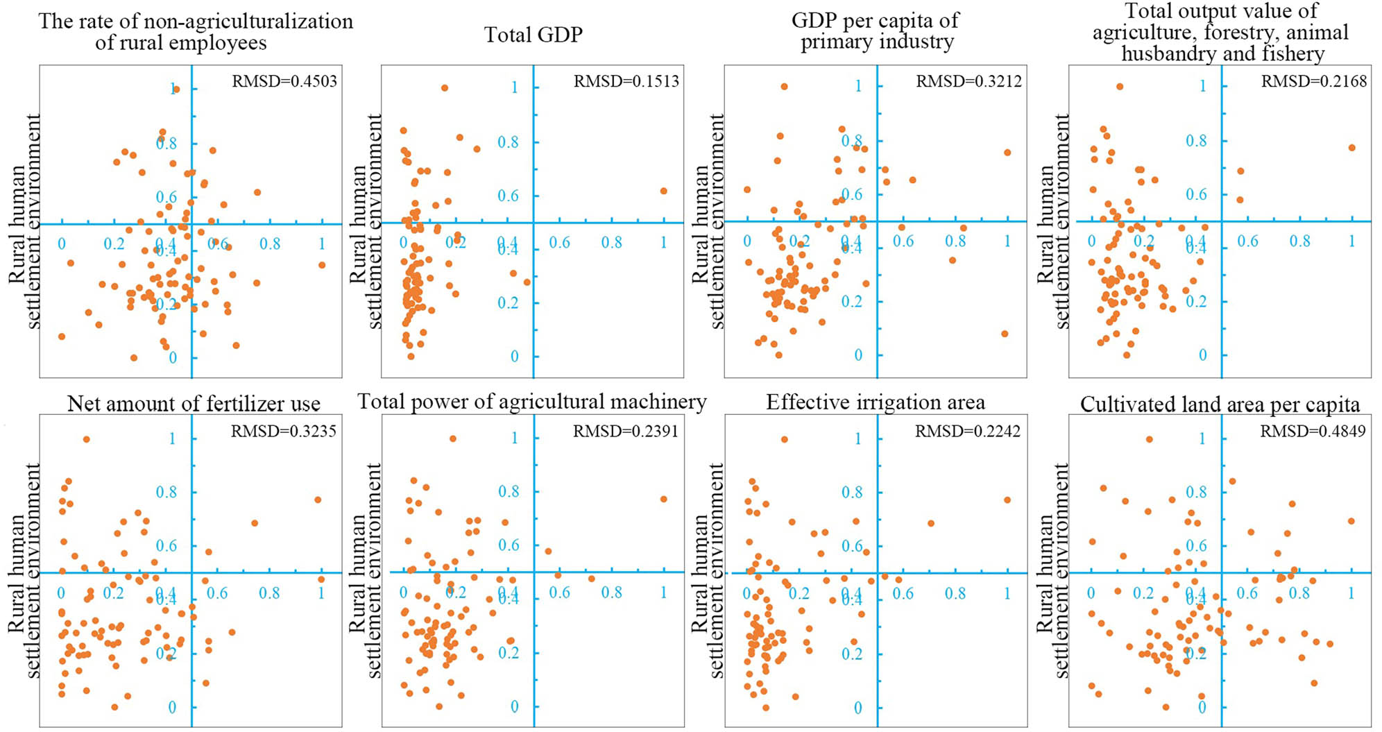
Trade-off analysis between RH settlement environment and eight dominant human factors.
4.3 The classification of driving types of RH settlement environment
Based on the evaluation of impact of human factors on the RH settlement environment, the administrative divisions, and the attributes of the eight dominant human factors, the driving types of RH settlement environment were classified to identify the spatial differentiation of impact factors of RH settlement environment in Gansu Province. The grouping tools within the ArcGIS 10.2 Mapping Clusters toolset were used to determine the optimal number of groups based on the F-statistics. According to the calculation, when the number of groups is 4, the value of F reaches 14.1331. F increases as the number of groups increases. Therefore, Gansu Province is classified into four driving types of RH settlement environment (Figure 6), such as comprehensive type (economic, social, and production conditions have a similar impact on the quality of RH settlement environment), economy-production-dominated and society-assisted type (compared with social conditions, economic and production conditions have greater impacts on quality of RH settlement environment and are dominant factors. Social conditions are assistant factors), economy-production-dominated and society-restricted type (economic and production conditions are significantly better than social conditions and have a positive impact on the quality of RH settlement environment; economic conditions have a negative impact on it), and economy-production-society-restricted type (economic, production, and social conditions are poor, and key factors restricting the improvement of quality of RH settlement environment). Among these, the comprehensive type accounts for 77.01%.

The classification of driving types of RH settlement environment.
The driving type of RH settlement environment in Gansu province is dominated by comprehensive type, including 61 counties (districts), accounting for 77.01% of all counties (districts). They are mainly distributed in the center of Gansu and east of Lanzhou. It is followed by economy-production-society-restricted type, which includes eight counties (districts), mainly distributed in Gannan Prefecture, Subei Mongolian Autonomous County, and Akse Kazak Autonomous County, and all are minority counties. The economy-production-dominated and society-assisted type include seven counties (districts), mainly distributed in some counties and districts in Jiuquan, Jiayuguan, and Zhangye of west of Gansu. The economy-production-dominated and society-restricted type includes five counties (districts), mainly distributed in north of Lanzhou. To improve the level of RH settlement environment and reduce the difference in it among different regions, it is necessary to adopt different methods for regions with different driving types of RH settlement environment.
5 Discussion
In this study, an evaluation index system of quality of RH settlement environment was established from four aspects, such as production and living environment, infrastructure environment, public service facility environment, and ecological environment. In addition, the impact of human factors, such as social conditions on RH settlement environment, economic conditions, and production conditions, was analyzed. Through ImPACT and trade-off analysis, eight indicators, such as the rate of non-agriculturalization of rural employees, total GDP, GDP per capita of the primary industry, total output value of agriculture, forestry, animal husbandry, and fishery, net amount of fertilizer use, total power of agricultural machinery, effective irrigation area, and cultivated land area per capita, are dominant human factors that affect the spatial differentiation of quality of RH settlement environment in Gansu Province. Thus, we should increase investment in hardware facilities such as rural infrastructure, public service facilities, and sanitation facilities according to the construction requirements of RH settlement environment. Through fiscal, taxation, investment, and other policies, we will create a good development environment for the rural areas of Gansu and realize the balanced development of the RH settlement environment. However, because of the limitation of data availability, we only selected a time node to conduct research. We cannot identify the time evolution of the quality of RH settlement environment. In the future, we can use multi-temporal data to study the evolution of regional RH settlement environment and explore the dominant human factor affecting the spatiotemporal change of regional RH settlement environment [29].
There are four driving types of RH settlement environment such as the comprehensive type, economy-production-dominated and society-assisted type, economy-production-dominated and society-restricted type, and economy-production-society-restricted type. This indicates that the society, economy, and production technologies guided by new urbanization have important impacts on the quality of RH settlement environment. The optimization and improvement of RH settlement environment in Gansu Province should focus on completing rural social insurance, improving the rural economic development, and strengthening technological innovation [30]. This study provides a reference for Gansu Province to formulate strategies for the optimization and improvement of RH settlement environment in accordance with local conditions and achieves a sustainable strategy from part to whole. However, the RH settlement environment is a complex systematic project, subject to not only the impact of national and local macro policies but also the interference of the behavior of rural multi-development subject. Thus, how to condense the optimization timing of different types of areas as well as design supporting optimization paths and schemes in accordance with local conditions will be the focus of future research [30].
6 Conclusions
The overall quality of RH settlement environment in Gansu Province is not high, and the spatial distribution has obvious regional differences, showing a decreasing trend from “west to east.” The west of Lanzhou has relatively high quality, mainly are medium and high-level areas. More than 90% of the counties (districts) in the east of Lanzhou have poor environmental quality, mainly are low and relatively low-level areas. In addition, the differences in spatial pattern of the production and living environment as well as infrastructure environment between eastern and western regions are significant. These public service facilities environment and ecological environment are not significant.
Six indices, such as the rate of non-agriculturalization of rural employees, total GDP, GDP per capita of the primary industry, total power of agricultural machinery, effective irrigation area, and cultivated land area per capita, have significant positive impacts on the RH settlement environment. The total output value of agriculture, forestry, animal husbandry, and fishery and the net amount of fertilizer use have significant negative impacts on it.
Indices reflecting economic and production conditions per capita are dominant factors affecting the quality of RH settlement environment in each county (district). Indices reflecting total value of economic and production conditions have relatively weak impacts on the quality of RH settlement environment in each county (district). The trade-off relationship between the environmental quality index and these eight dominant factors is mainly low–low, which indicates that the human factors with small values are the main reason for the poor quality of the RH settlement environment.
Based on the dominant human factors, Gansu Province is classified into four driving types of RH settlement environment such as the comprehensive type, economy-production-dominated and society-assisted type, economy-production-dominated and society-restricted type, and economy-production-society-restricted type. Among these, the proportion of comprehensive type, which is comprehensively influenced by the economic, social, and production conditions, accounts for 77.01%.
Acknowledgments
The authors express their sincere thanks for the financial support from National Natural Science Foundation of China. This research was funded by the National Natural Science Foundation of China, grant number 41961033.
Author contributions: Libang Ma and Huan Li designed the research. Haojian Dou, Jie Bo, and Fang Fang processed the data and made comments and suggestions on the manuscript. All authors contributed to the results, discussions, and writing of the manuscript.
References
[1] Schaltegger S, Sturm A. Okologieinduzierte Entscheidungsprobleme des Managements. Ansatzpunkte zur Ausgestaltung von Instrumenten [Ecology induced management decision support. Starting points for instrument formation]. WWZ Discussion Paper No. 8914. Basel: WWZ; 1989.Search in Google Scholar
[2] Doxiadis CA. Ekistics: An Introduction to the Science of Human Settlements. vol. 41–49, Athens: Athens Publishing Center; 1968. p. 81.Search in Google Scholar
[3] Zeng JX, Yang QQ, Liu YJ, Zhao CF, Li BH. Research on evolution and influential mechanism for rural human settlement in motional key ecological function areas: a case of Lichuan. Hum Geogr. 2016;1:81–8.Search in Google Scholar
[4] Wu LY. Introduction to sciences of human settlements. Beijing: China Building Industry Press; 2001.Search in Google Scholar
[5] Liu ZH, Wang LL, Zhang B, Yu X, Zhou XD. The evaluation of urban human settlements based on fuzzy matter-element model: taking 11 prefecture-level cities in Jiangxi Province as examples. Environ Res Lett. 2018;1053:1.10.1088/1742-6596/1053/1/012132Search in Google Scholar
[6] Cui C, Wang Z, He P, Yuan S, Kang C. Escaping from pollution: the effect of air quality on inter-city population mobility in China. Environ Res Lett. 2019;14:12.10.1088/1748-9326/ab5039Search in Google Scholar
[7] Li BH, Zeng JX, Hu J. Progress and prospects on the research of rural human settlement environment. Geogr Geo-Inf Sci. 2008;5:74–8.Search in Google Scholar
[8] Michael C. Rural settlement and land use. Chicago: Aldine Transaction; 2007.Search in Google Scholar
[9] Daniel T, Kenneth M. Emerging rural settlement patterns and the geographic redistribution of America’s new immigrants. Rural Sociol. 2006;71(1):109–31.10.1526/003601106777789828Search in Google Scholar
[10] Ma JJ, Zeng JX. Study on the longevity phenomena and human settlements in rural China: taking Zhongxiang city as an example. Geograph Res. 2012;31(3):450–60.Search in Google Scholar
[11] Meier MA. Ecoefficiency evaluation of waste gas purification systems in the chemical industry. Reprod Biol Endocrinol. 1997;2(25):35.Search in Google Scholar
[12] Tang N, Wang C, Du XZ. Evaluation of rural human settlements quality and its differentiated optimization in Chongqing Municipality. Econ Geograph. 2018;38(1):160–5+173.Search in Google Scholar
[13] Xiao H, Wang X, Zhang X, Li L, Yu Z. Planning activities improvements responding local interests change through participatory approach. Open Geosci. 2019;11(1):697–707.10.1515/geo-2019-0055Search in Google Scholar
[14] Feng ZM, Tang Y, Yang YZ. Establishment and application of human settlements environment index model (HEI) based on GIS. Acta Geograph Sin. 2008;63(12):1327–36.Search in Google Scholar
[15] Hao HM, Ren ZY. Evaluation of nature suitability for human settlement in Shaanxi Province based on grid data. Acta Geograph Sin. 2009;64(4):498–506.Search in Google Scholar
[16] 2019 Gansu Development Yearbook. China Statistics Press; 2019.Search in Google Scholar
[17] 2018 Gansu Development Yearbook. China Statistics Press; 2018.Search in Google Scholar
[18] 2018 Gansu Rural Yearbook. China Statistical Press; 2018.Search in Google Scholar
[19] 2018 China Statistical Yearbook. China Statistics Press; 2018.Search in Google Scholar
[20] 2018 China Rural Yearbook. China Statistics Press; 2018.Search in Google Scholar
[21] Lama N, Boracchi P, Biganzoli E. Exploration of distributional models for a novel intensity-dependent normalization procedure in censored gene expression data. Comput Stat Data Anal. 2008;53(5):1906–22. 10.1016/j.carol carroll sda 2008.11.026.Search in Google Scholar
[22] Ehrlich PR, Holdrens JP. The impact of population growth. Science. 1971;171:1212–7.10.1126/science.171.3977.1212Search in Google Scholar
[23] Waggoner PR, Ausubel JH. A framework for sustainability science a renovated IPAT identity. Proc Natl Acad Sci U S A. 2002;99:7860–5.10.1073/pnas.122235999Search in Google Scholar
[24] Yang XZ, Wang Q. Evaluation of rural human settlement quality difference and its driving factors in tourism area of southern Anhui Province. Acta Geograph Sin. 2013;68(6):851–67.Search in Google Scholar
[25] Yang RB, Yang DY. Traditional settlements study on sciences of human settlements in Erhai Lake Region. Environ Res Lett. 2019;592:1.Search in Google Scholar
[26] York R, Rosa E, Dietz T. STIRPAT, IPAT and ImPACT: analytic tools for unpacking the driving forces of environmental impacts. Ecol Econ. 2003;23:351–65.10.1016/S0921-8009(03)00188-5Search in Google Scholar
[27] Bradfordand JB, D’Amato AW. Recognizing trade-offs in multi-objective land management. Front Ecol Environ. 2012;10:210–6.10.1890/110031Search in Google Scholar
[28] Lu N, Fu BJ, Jin TT, Chang RY. Trade-off analyses of multiple ecosystem services by plantations along a precipitation gradient across Loess Plateau landscapes. Landsc Ecol. 2014;29:1697–708.10.1007/s10980-014-0101-4Search in Google Scholar
[29] Yang J, You HL, Zhang YQ, Jin C. Research progress on human settlements: from traditional data to big data+. Prog Geograph. 2020;39(1):166–76.10.18306/dlkxjz.2020.01.016Search in Google Scholar
[30] Han YM. Evaluation on the county of human settlement environment and analysis of spatio-temporal variation in northwestern province. China: LanZhou; 2018.Search in Google Scholar
© 2020 Haojian Dou et al., published by De Gruyter
This work is licensed under the Creative Commons Attribution 4.0 International License.
Articles in the same Issue
- Regular Articles
- The simulation approach to the interpretation of archival aerial photographs
- The application of137Cs and210Pbexmethods in soil erosion research of Titel loess plateau, Vojvodina, Northern Serbia
- Provenance and tectonic significance of the Zhongwunongshan Group from the Zhongwunongshan Structural Belt in China: insights from zircon geochronology
- Analysis, Assessment and Early Warning of Mudflow Disasters along the Shigatse Section of the China–Nepal Highway
- Sedimentary succession and recognition marks of lacustrine gravel beach-bars, a case study from the Qinghai Lake, China
- Predicting small water courses’ physico-chemical status from watershed characteristics with two multivariate statistical methods
- An Overview of the Carbonatites from the Indian Subcontinent
- A new statistical approach to the geochemical systematics of Italian alkaline igneous rocks
- The significance of karst areas in European national parks and geoparks
- Geochronology, trace elements and Hf isotopic geochemistry of zircons from Swat orthogneisses, Northern Pakistan
- Regional-scale drought monitor using synthesized index based on remote sensing in northeast China
- Application of combined electrical resistivity tomography and seismic reflection method to explore hidden active faults in Pingwu, Sichuan, China
- Impact of interpolation techniques on the accuracy of large-scale digital elevation model
- Natural and human-induced factors controlling the phreatic groundwater geochemistry of the Longgang River basin, South China
- Land use/land cover assessment as related to soil and irrigation water salinity over an oasis in arid environment
- Effect of tillage, slope, and rainfall on soil surface microtopography quantified by geostatistical and fractal indices during sheet erosion
- Validation of the number of tie vectors in post-processing using the method of frequency in a centric cube
- An integrated petrophysical-based wedge modeling and thin bed AVO analysis for improved reservoir characterization of Zhujiang Formation, Huizhou sub-basin, China: A case study
- A grain size auto-classification of Baikouquan Formation, Mahu Depression, Junggar Basin, China
- Dynamics of mid-channel bars in the Middle Vistula River in response to ferry crossing abutment construction
- Estimation of permeability and saturation based on imaginary component of complex resistivity spectra: A laboratory study
- Distribution characteristics of typical geological relics in the Western Sichuan Plateau
- Inconsistency distribution patterns of different remote sensing land-cover data from the perspective of ecological zoning
- A new methodological approach (QEMSCAN®) in the mineralogical study of Polish loess: Guidelines for further research
- Displacement and deformation study of engineering structures with the use of modern laser technologies
- Virtual resolution enhancement: A new enhancement tool for seismic data
- Aeromagnetic mapping of fault architecture along Lagos–Ore axis, southwestern Nigeria
- Deformation and failure mechanism of full seam chamber with extra-large section and its control technology
- Plastic failure zone characteristics and stability control technology of roadway in the fault area under non-uniformly high geostress: A case study from Yuandian Coal Mine in Northern Anhui Province, China
- Comparison of swarm intelligence algorithms for optimized band selection of hyperspectral remote sensing image
- Soil carbon stock and nutrient characteristics of Senna siamea grove in the semi-deciduous forest zone of Ghana
- Carbonatites from the Southern Brazilian platform: I
- Seismicity, focal mechanism, and stress tensor analysis of the Simav region, western Turkey
- Application of simulated annealing algorithm for 3D coordinate transformation problem solution
- Application of the terrestrial laser scanner in the monitoring of earth structures
- The Cretaceous igneous rocks in southeastern Guangxi and their implication for tectonic environment in southwestern South China Block
- Pore-scale gas–water flow in rock: Visualization experiment and simulation
- Assessment of surface parameters of VDW foundation piles using geodetic measurement techniques
- Spatial distribution and risk assessment of toxic metals in agricultural soils from endemic nasopharyngeal carcinoma region in South China
- An ABC-optimized fuzzy ELECTRE approach for assessing petroleum potential at the petroleum system level
- Microscopic mechanism of sandstone hydration in Yungang Grottoes, China
- Importance of traditional landscapes in Slovenia for conservation of endangered butterfly
- Landscape pattern and economic factors’ effect on prediction accuracy of cellular automata-Markov chain model on county scale
- The influence of river training on the location of erosion and accumulation zones (Kłodzko County, South West Poland)
- Multi-temporal survey of diaphragm wall with terrestrial laser scanning method
- Functionality and reliability of horizontal control net (Poland)
- Strata behavior and control strategy of backfilling collaborate with caving fully-mechanized mining
- The use of classical methods and neural networks in deformation studies of hydrotechnical objects
- Ice-crevasse sedimentation in the eastern part of the Głubczyce Plateau (S Poland) during the final stage of the Drenthian Glaciation
- Structure of end moraines and dynamics of the recession phase of the Warta Stadial ice sheet, Kłodawa Upland, Central Poland
- Mineralogy, mineral chemistry and thermobarometry of post-mineralization dykes of the Sungun Cu–Mo porphyry deposit (Northwest Iran)
- Main problems of the research on the Palaeolithic of Halych-Dnister region (Ukraine)
- Application of isometric transformation and robust estimation to compare the measurement results of steel pipe spools
- Hybrid machine learning hydrological model for flood forecast purpose
- Rainfall thresholds of shallow landslides in Wuyuan County of Jiangxi Province, China
- Dynamic simulation for the process of mining subsidence based on cellular automata model
- Developing large-scale international ecological networks based on least-cost path analysis – a case study of Altai mountains
- Seismic characteristics of polygonal fault systems in the Great South Basin, New Zealand
- New approach of clustering of late Pleni-Weichselian loess deposits (L1LL1) in Poland
- Implementation of virtual reference points in registering scanning images of tall structures
- Constraints of nonseismic geophysical data on the deep geological structure of the Benxi iron-ore district, Liaoning, China
- Mechanical analysis of basic roof fracture mechanism and feature in coal mining with partial gangue backfilling
- The violent ground motion before the Jiuzhaigou earthquake Ms7.0
- Landslide site delineation from geometric signatures derived with the Hilbert–Huang transform for cases in Southern Taiwan
- Hydrological process simulation in Manas River Basin using CMADS
- LA-ICP-MS U–Pb ages of detrital zircons from Middle Jurassic sedimentary rocks in southwestern Fujian: Sedimentary provenance and its geological significance
- Analysis of pore throat characteristics of tight sandstone reservoirs
- Effects of igneous intrusions on source rock in the early diagenetic stage: A case study on Beipiao Formation in Jinyang Basin, Northeast China
- Applying floodplain geomorphology to flood management (The Lower Vistula River upstream from Plock, Poland)
- Effect of photogrammetric RPAS flight parameters on plani-altimetric accuracy of DTM
- Morphodynamic conditions of heavy metal concentration in deposits of the Vistula River valley near Kępa Gostecka (central Poland)
- Accuracy and functional assessment of an original low-cost fibre-based inclinometer designed for structural monitoring
- The impacts of diagenetic facies on reservoir quality in tight sandstones
- Application of electrical resistivity imaging to detection of hidden geological structures in a single roadway
- Comparison between electrical resistivity tomography and tunnel seismic prediction 303 methods for detecting the water zone ahead of the tunnel face: A case study
- The genesis model of carbonate cementation in the tight oil reservoir: A case of Chang 6 oil layers of the Upper Triassic Yanchang Formation in the western Jiyuan area, Ordos Basin, China
- Disintegration characteristics in granite residual soil and their relationship with the collapsing gully in South China
- Analysis of surface deformation and driving forces in Lanzhou
- Geochemical characteristics of produced water from coalbed methane wells and its influence on productivity in Laochang Coalfield, China
- A combination of genetic inversion and seismic frequency attributes to delineate reservoir targets in offshore northern Orange Basin, South Africa
- Explore the application of high-resolution nighttime light remote sensing images in nighttime marine ship detection: A case study of LJ1-01 data
- DTM-based analysis of the spatial distribution of topolineaments
- Spatiotemporal variation and climatic response of water level of major lakes in China, Mongolia, and Russia
- The Cretaceous stratigraphy, Songliao Basin, Northeast China: Constrains from drillings and geophysics
- Canal of St. Bartholomew in Seča/Sezza: Social construction of the seascape
- A modelling resin material and its application in rock-failure study: Samples with two 3D internal fracture surfaces
- Utilization of marble piece wastes as base materials
- Slope stability evaluation using backpropagation neural networks and multivariate adaptive regression splines
- Rigidity of “Warsaw clay” from the Poznań Formation determined by in situ tests
- Numerical simulation for the effects of waves and grain size on deltaic processes and morphologies
- Impact of tourism activities on water pollution in the West Lake Basin (Hangzhou, China)
- Fracture characteristics from outcrops and its meaning to gas accumulation in the Jiyuan Basin, Henan Province, China
- Impact evaluation and driving type identification of human factors on rural human settlement environment: Taking Gansu Province, China as an example
- Identification of the spatial distributions, pollution levels, sources, and health risk of heavy metals in surface dusts from Korla, NW China
- Petrography and geochemistry of clastic sedimentary rocks as evidence for the provenance of the Jurassic stratum in the Daqingshan area
- Super-resolution reconstruction of a digital elevation model based on a deep residual network
- Seismic prediction of lithofacies heterogeneity in paleogene hetaoyuan shale play, Biyang depression, China
- Cultural landscape of the Gorica Hills in the nineteenth century: Franciscean land cadastre reports as the source for clarification of the classification of cultivable land types
- Analysis and prediction of LUCC change in Huang-Huai-Hai river basin
- Hydrochemical differences between river water and groundwater in Suzhou, Northern Anhui Province, China
- The relationship between heat flow and seismicity in global tectonically active zones
- Modeling of Landslide susceptibility in a part of Abay Basin, northwestern Ethiopia
- M-GAM method in function of tourism potential assessment: Case study of the Sokobanja basin in eastern Serbia
- Dehydration and stabilization of unconsolidated laminated lake sediments using gypsum for the preparation of thin sections
- Agriculture and land use in the North of Russia: Case study of Karelia and Yakutia
- Textural characteristics, mode of transportation and depositional environment of the Cretaceous sandstone in the Bredasdorp Basin, off the south coast of South Africa: Evidence from grain size analysis
- One-dimensional constrained inversion study of TEM and application in coal goafs’ detection
- The spatial distribution of retail outlets in Urumqi: The application of points of interest
- Aptian–Albian deposits of the Ait Ourir basin (High Atlas, Morocco): New additional data on their paleoenvironment, sedimentology, and palaeogeography
- Traditional agricultural landscapes in Uskopaljska valley (Bosnia and Herzegovina)
- A detection method for reservoir waterbodies vector data based on EGADS
- Modelling and mapping of the COVID-19 trajectory and pandemic paths at global scale: A geographer’s perspective
- Effect of organic maturity on shale gas genesis and pores development: A case study on marine shale in the upper Yangtze region, South China
- Gravel roundness quantitative analysis for sedimentary microfacies of fan delta deposition, Baikouquan Formation, Mahu Depression, Northwestern China
- Features of terraces and the incision rate along the lower reaches of the Yarlung Zangbo River east of Namche Barwa: Constraints on tectonic uplift
- Application of laser scanning technology for structure gauge measurement
- Calibration of the depth invariant algorithm to monitor the tidal action of Rabigh City at the Red Sea Coast, Saudi Arabia
- Evolution of the Bystrzyca River valley during Middle Pleistocene Interglacial (Sudetic Foreland, south-western Poland)
- A 3D numerical analysis of the compaction effects on the behavior of panel-type MSE walls
- Landscape dynamics at borderlands: analysing land use changes from Southern Slovenia
- Effects of oil viscosity on waterflooding: A case study of high water-cut sandstone oilfield in Kazakhstan
- Special Issue: Alkaline-Carbonatitic magmatism
- Carbonatites from the southern Brazilian Platform: A review. II: Isotopic evidences
- Review Article
- Technology and innovation: Changing concept of rural tourism – A systematic review