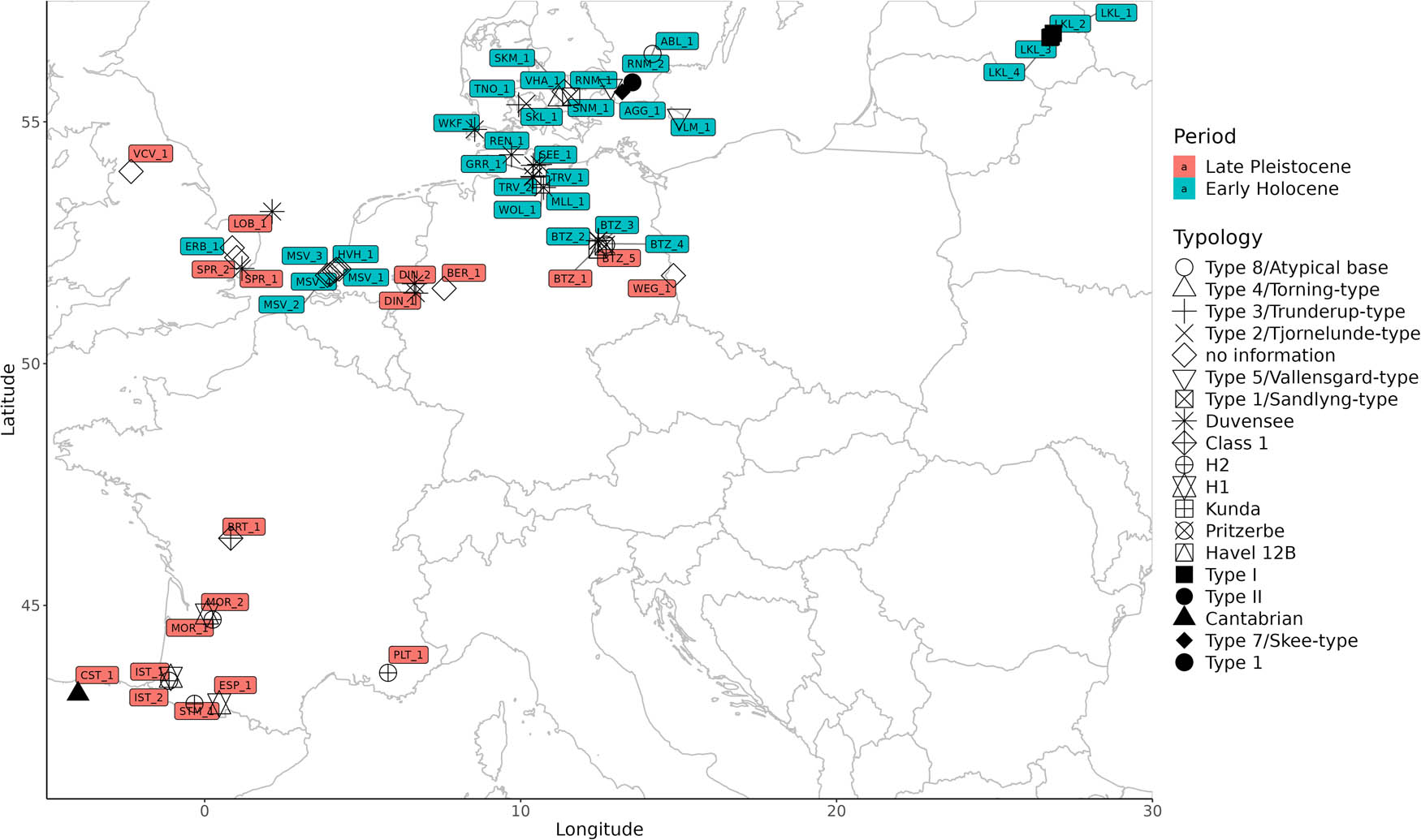
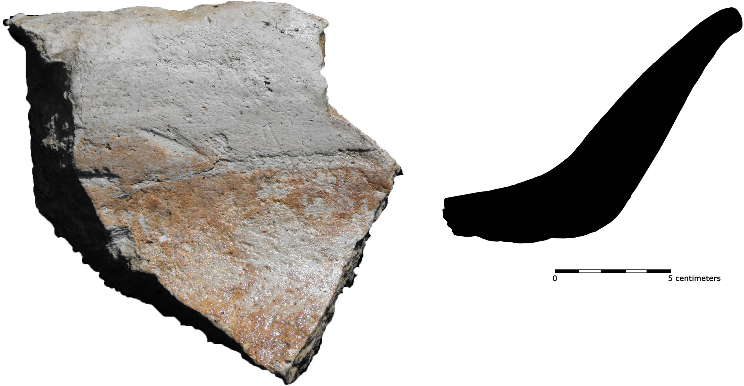
Studies on prehistoric osseous barbed points have relied heavily on typology in linking presumed types to broader techno-complexes, and for making chronological inferences. The accumulation of both new finds and of radiocarbon dates obtained directly on such artefacts, however, has revealed that (i) shape variability defies neat typological divisions, and that (ii) chronological inferences based on typology often fail. To further query these issues and to better understand the design choices and cultural evolutionary dynamics within this artefact class, we present a 2D open-outline geometric morphometric analysis of 50 directly dated Late Pleistocene and Early Holocene osseous barbed points primarily from northern and western Europe. The results indicate that (a) different components (tip, base, and barbs) of these artefacts were subject to varying design constraints and that (b) there is no clear-cut distinction between Final Palaeolithic and Mesolithic point traditions. Different techno-functional components evolved at various rates while specimens assigned to the same type and/or techno-complex are only occasionally morphologically similar. The results reflect a relatively low level of normativity for this artefact class and likely a repeated convergence on similar design elements. We propose that interpretations linked to cultural dynamics, individual craft agency, and repeated convergence on locally optimal designs may offer more satisfying avenues for thinking about the barbed points of this period.
Tracing the patterns of wealth consumption within and between burial communities can reveal different aspects of the sociopolitical and economic abilities of and relations between individuals, groups, and whole communities. For a cross-cultural comparison, burial communities of the cultural groups of the Hungarian Middle Bronze Age Vatya and Füzesabony pottery styles in the Carpathian Basin were chosen. Special emphasis is put on the development of the wealth consumption during the late phase of the Middle Bronze Age. It could be shown that Vatya and Füzesabony communities exhibit very similar patterns of wealth consumption and seemingly sociopolitical organization. In the cemetery of Dunaújváros-Duna-dűlő, a dynamic competition and cooperation between different social segments can be witnessed, representing an arena in which signaling the individual’s and groups’ ability to participate in sociopolitical organization of the burial community took place. The wealth consumption over the whole considered geographical space, and beyond, changes during the late Middle Bronze Age. It can be assumed that during the times of change, cultural convergence increases, as changes in burial rites and wealth consumption suggest. This development is possible because Vatya and Füzesabony shared a very similar sociopolitical organization as well as the perception of wealth and how it should be consumed.
Investigation into the utilitarian function of mortuary vessels is often a neglected aspect of ceramic examination. Since, in most cases, a direct link can be assumed between the vessels’ size, form, and most optimal utilitarian function, morphometry-based ceramic categories – along with ethnoarchaeological examples – can help to understand the role of these vessels in funerary contexts. This article focuses on the relationship between the utilitarian function of ceramics and their roles in graves through the analysis of eight Early Copper Age (4400/4300–4000/3900 BC) burial sites, associated with Tiszapolgár and Bodrogkeresztúr ceramic styles, from the Upper Tisza Region (Hungary). The deposition of ceramic assemblages in graves became common in this period; however, a systematic analysis of their function has never been carried out before. In this study, a morphometry-based methodology was developed to establish the vessels’ utilitarian function. These functions were considered in the analysis of the composition of mortuary assemblages, and how they may reflect social status or gender roles of the deceased individual. Results indicate that the Tiszapolgár and Bodrogkeresztúr assemblages cannot be unequivocally distinguished from each other based on morphometric and functional criteria, suggesting similar functional roles in the past funerary contexts.
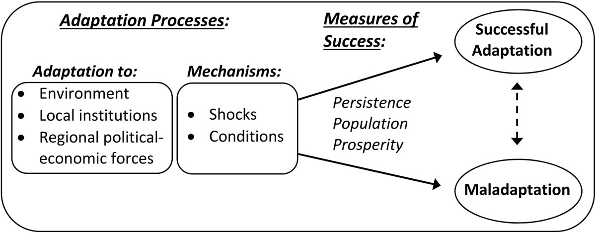
One of archaeology’s principal contributions to knowledge is its ability to track human actions and social conditions over long periods of time. I describe an approach to operationalizing this insight for the rise and fall of cities and other settlement over time. Cities that survive and thrive are considered successful, and urban success can be measured along three dimensions: persistence, population, and prosperity. Successful cities were those whose leaders, residents, and institutions found ways to adapt to a range of shocks and conditions, including the environment, local institutions, and regional political and economic forces. Urban success is therefore due to processes of urban adaptation that operated over long periods of time. I outline a conceptual and methodological approach to urban success and position the concept with respect to notions of adaptation and time scales in sustainability science and the social and historical sciences more broadly.
Solange Rigaud, Alain Queffelec, François-Xavier Le Bourdonnec, Saltanat Alisher kyzy, Stanley H. Ambrose, Ronan Ledevin, Redzhep Kurbanov, Alexandra Buzhilova, Natalia Berezina, Rustam H. Ziganshin, Svetlana Shnaider
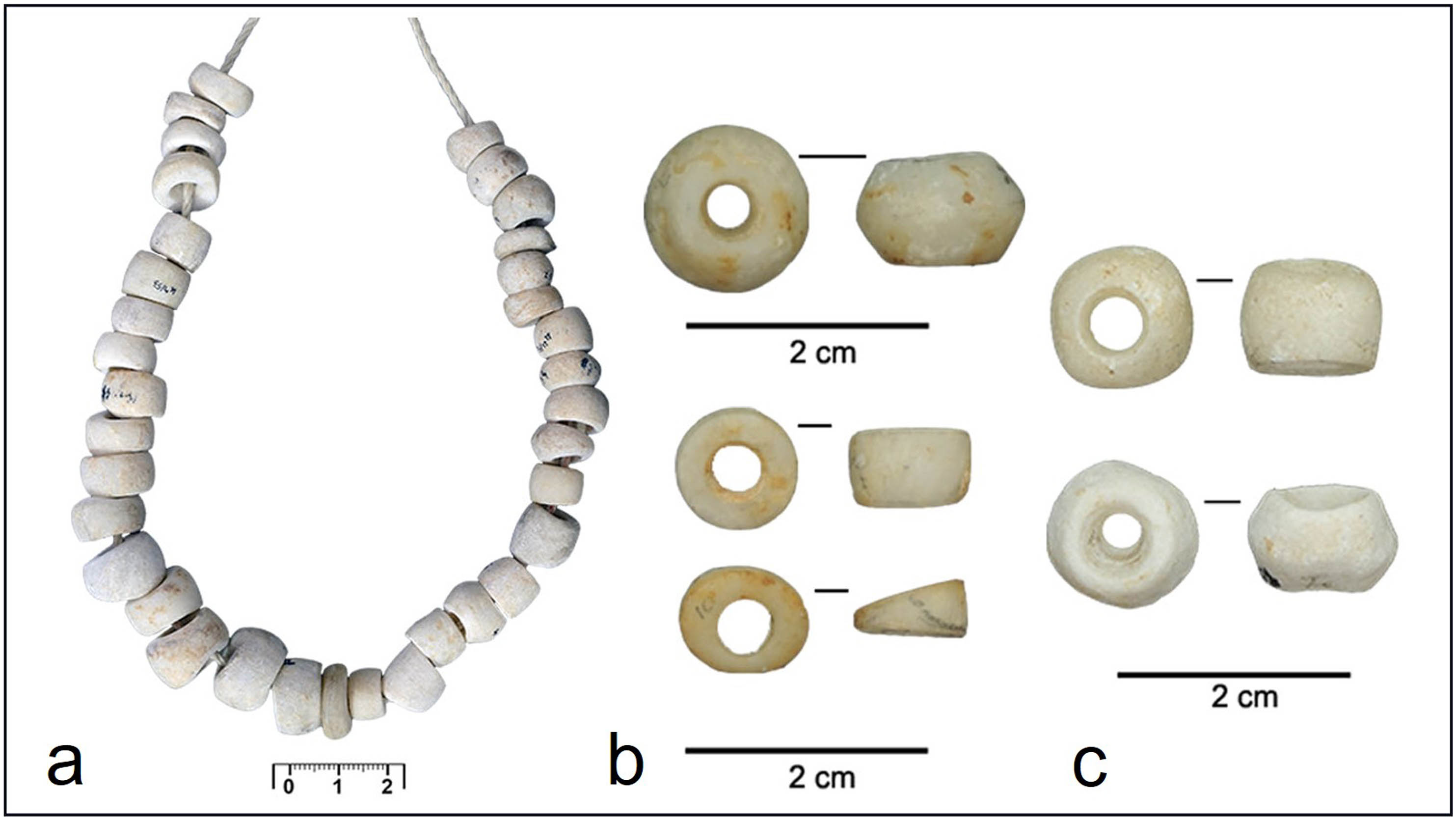
This article studies the discoid Didacna sp. shell beads discovered at Kaylu, a Middle Holocene burial site located in Southern Turkmenistan. Microscopic, morphometric, spectrometric, and SEM analyses were carried out on the material to identify how the beads were manufactured and used. New radiocarbon dating and bioanthropological data to age and sex the two skeletons discovered in the burials are provided. A regional synthesis shows that personal ornaments from the Caspian region were diversified through time and that a stylistic shift between the last foragers and the first farmers occurred. We also observed strong correspondences between the personal ornaments documented in the northern, eastern, and western Caspian Sea during the Neolithic, with no evidence of similar symbolic production in Northern Iran. We propose that a northern route may have allowed the diffusion of common ornamental traditions in the Caspian region to the exclusion of the southern Caspian. Alternatively, discontinuities in material culture diffusion in coastal areas could be evidence of maritime voyaging. Seafaring may have granted the fast and spatially erratic diffusion of specific bead types, people, information, knowledge, and symbols from both sides of the Caspian Sea, by long maritime voyages or by leapfrog diffusion during the Neolithic.
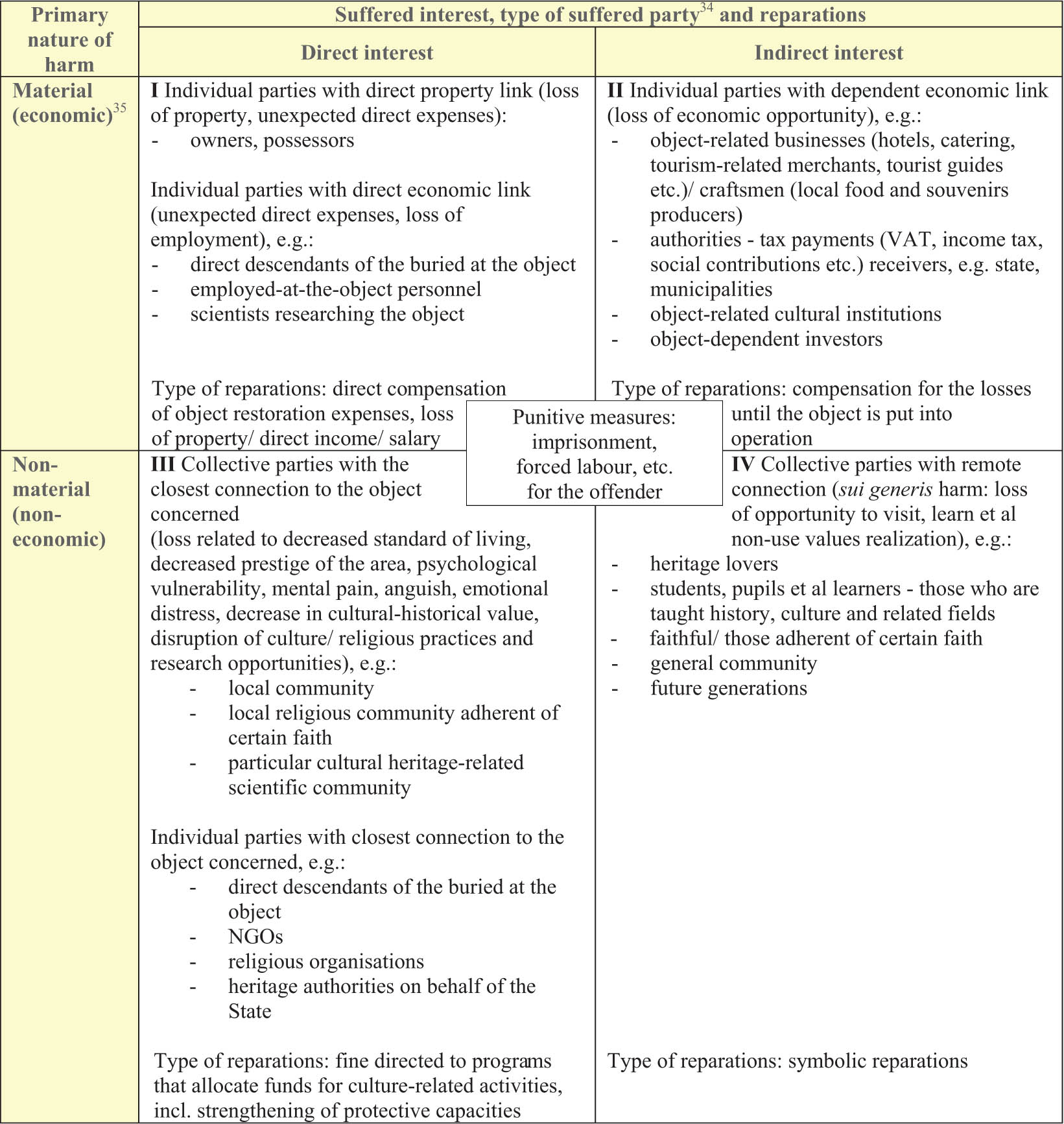
The aim of this research is to show how different groups of stakeholders are suffering as a result of heritage crime. Research primarily addresses Latvian situation (with international comparisons) in relation to archaeological sites as the most vulnerable, however, the findings can be applicable to other heritage objects and broader territory as well. Most of these stakeholders are currently limited in, if not denied, access to justice and rights for an effective remedy within the traditional criminal law system. Insufficient level of social awareness of socio-economic benefits and rights stemming from integrity, development, and use of archaeological sites together with existing legal constraints results in poor self-recognition by individuals and groups as victims of heritage crime. While suffered parties abstain from protecting their rights, there is lack of information and proactive action from public authorities including law enforcement. Current research analyses the nature and scope of immediate harm resulted from the damage of archaeological sites and the extended consequences of the heritage crime for the different stakeholders’ groups. It points at the inefficiency of standard retributive approach and evaluates benefits of restorative justice elements in reaching justice for heritage crime victims. The results could be used for better recognition of benefits, and therefore rights, stemming from intact archaeological sites, amending legal regulation, providing access to justice for suffered individual and collective parties, allowing recognition of mass victimisation and facilitating prevention of heritage crime.
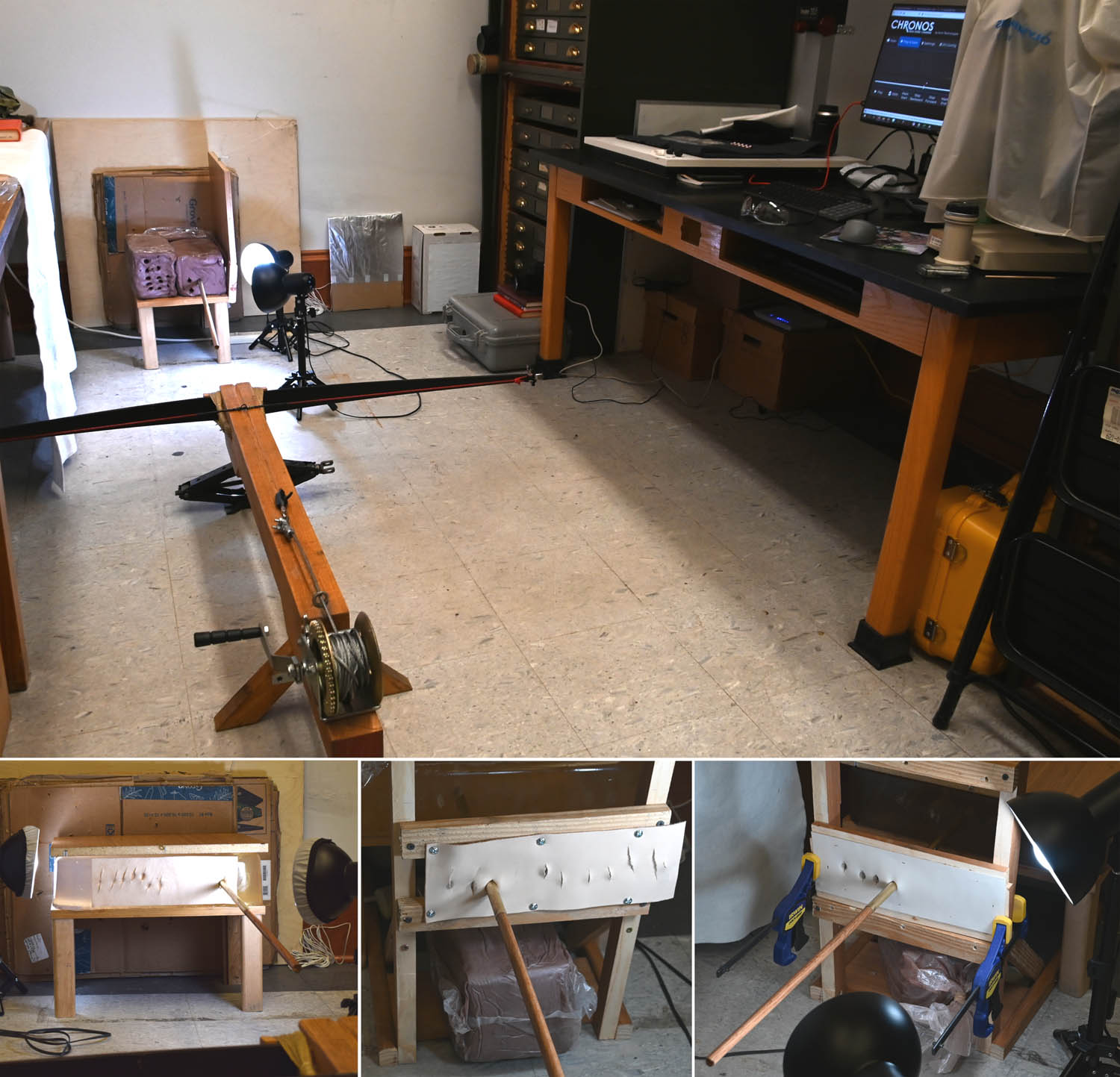
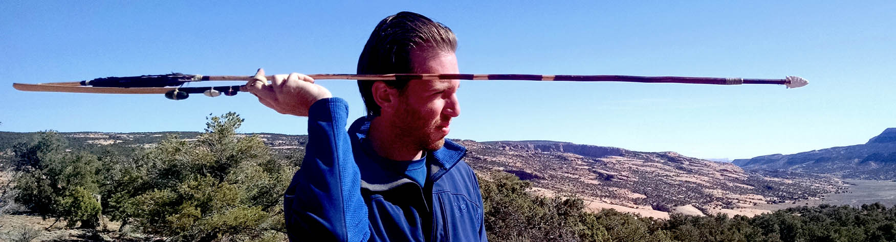
When they work, controlled experiments can efficiently and clearly reveal essential characteristics of the functions and performance of ancient hunting and fighting weapons. However, homogenous target media must be carefully validated to ensure that controlled tests capture the same variables that made weapons effective in their original application. Although homogenous flesh simulants have proven effective for studying firearms, the same simulants cannot be assumed to be effective when testing low-velocity cutting/piercing projectiles, which have significantly different performance characteristics than bullets. We build on past research showing that two flesh simulants that are commonly used by archaeologists, ballistics gelatin and pottery clay, fail to capture how atlatl darts and arrows perform when penetrating biological tissues. In accord with forensic research of knife-thrust attacks, natural and polymeric skin simulants may prove effective in future experiments, but this requires further research.
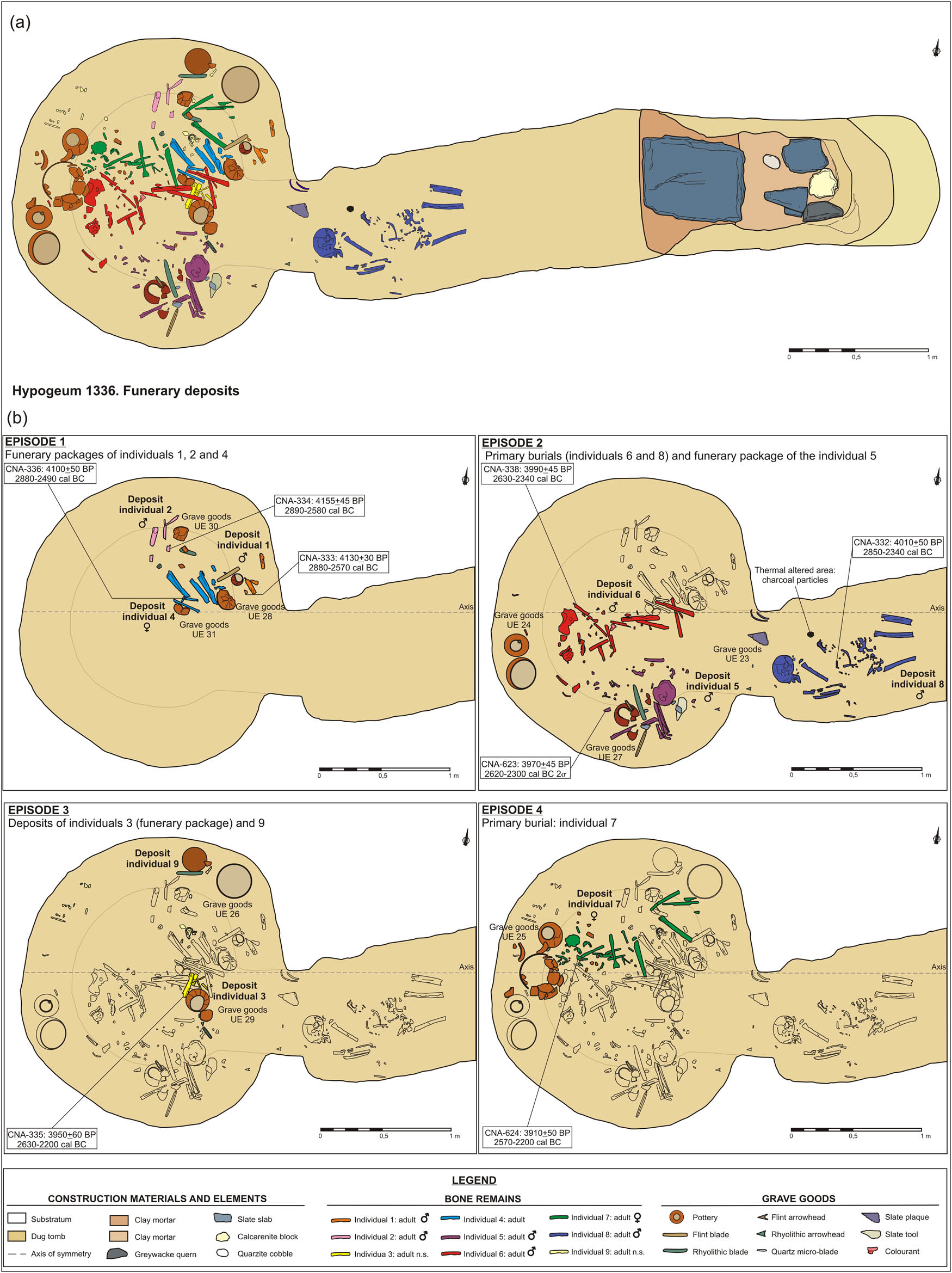
This study analyses the funerary activity of small collective tombs with a limited number of individuals in the southwest of the Iberian Peninsula during the Copper Age. These small burial spaces are one of the most frequent funerary manifestations and one of the most common forms of megalithic monumentality in the complex societies of this geographical area. The necropolis of La Orden-Seminario is put forward as a detailed case study, applying a multi-method approach that integrates the interrelated analysis of architecture, stratigraphy, funerary deposits, bioanthropological indicators, and chronological sequences. The research makes it possible to identify the overarching features that characterise these collective funerary activity: (a) the architectural and functional similarity between the hypogea and tholoi ; (b) the periodic remodelling and reorganisation of the burial spaces; (c) the formation of superimposed funerary levels articulated in various phases; (d) the short periods of time in each level, with a concentration of 1–5 generations; (e) the coexistence of primary and secondary funerary deposits; (f) the low minimum number of individuals and the non-existence of dissymmetric practices according to sex and/or age; (g) the uniformity of the grave goods, the fragmentation of the objects, and the deposition of offerings; and (h) reuse during the Early Bronze Age.
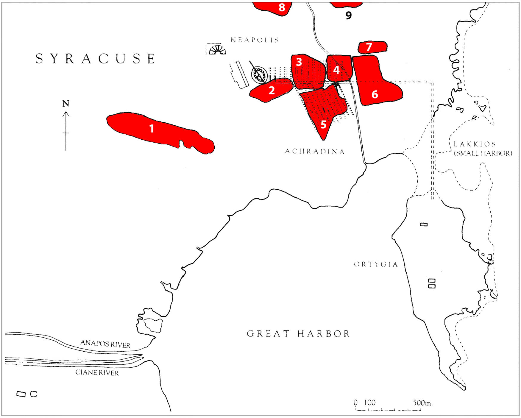
Fish and fish products are considered important sources of nutrition due to their high protein, fat, and fat-soluble vitamin content. These food items have been extensively discussed and celebrated in various genres of Greek literature. However, there is a discrepancy between the rich textual evidence of fish cooking and consumption and the limited archaeological evidence of fishing gear, especially with respect to Greek Sicily. Such scarcity of evidence is particularly evident in the Archaic period. To address the issue of fish consumption in Greek Sicily and to determine the role of fish in the local communities’ diet, this study focuses on the new data that have emerged from stable isotopes analysis on skeletal remains from a recently discovered Archaic period necropolis in Syracuse. The study analyzes the dietary habits of the individuals buried in the necropolis and establishes possible connections between burial practices and diet. Additionally, the study compares the dietary patterns with the social status of the individuals, as demonstrated by the funerary context. The comparison of the new evidence with similar contexts will allow for a critical review of the literary sources and the reinterpretation of the archaeological record. Through this, the study aims to establish the role of fish in the diet of the Greeks of Sicily and their significance at the dining table.
This study describes an effective protocol for naturalistic archaeological weapons experiments that improves cross-validation with controlled experiments and allows testing of multiple hypotheses. Stone-tipped atlatl darts and arrows were launched by skilled users against fresh carcasses, with high-speed cameras and radar guns capturing details of ballistic performance, impacts to bone and stone armatures, and other variables. The results pertaining to terminal ballistics in soft tissues are presented, with implications for what made ancient hunting projectiles effective and can be observed archaeologically. Fine-grained knappable stones seem to produce sharper armatures that can dramatically improve penetration, and presumably, lethality. Two commonly used metrics by archaeologists for estimating armature efficacy, tip cross-sectional area (TCSA), and perimeter (TCSP), are not among the significant variables for capturing penetration depth in soft tissues. However, armatures with larger TCSAs tend to be fitted to larger shafts that carry more energy and penetrate more deeply, providing one method for predicting wounding potential. The variability within weapon systems means that isolating efficacy to individual variables, such as tip cross-sectional size of stone armatures, can lead to erroneous interpretations.
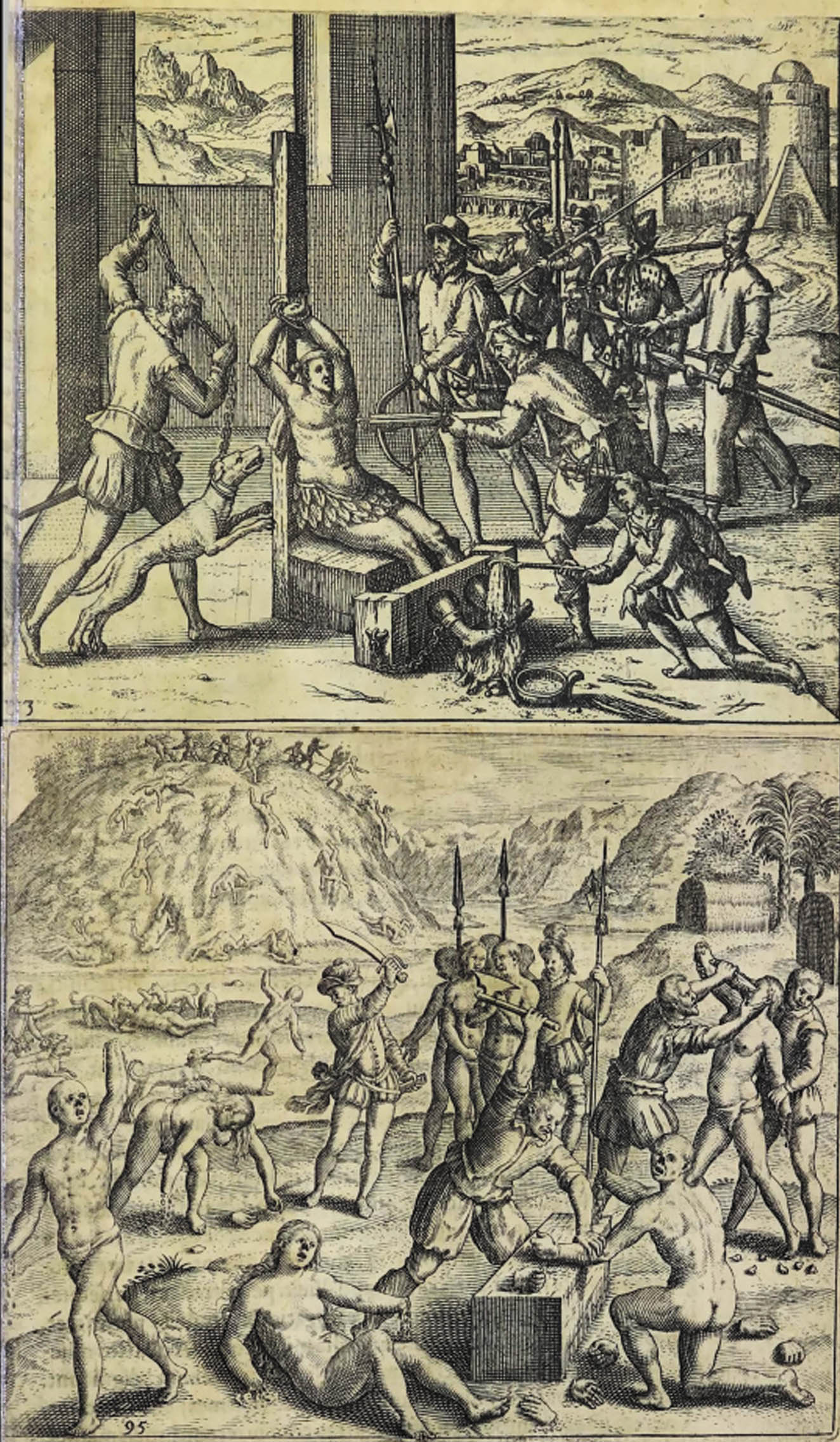
Newen Antug is a multicomponent (residential and funerary) archaeological site located in the Lácar basin south of Neuquén, Argentina, in the east Andean section of the binational basin of the Valdivia River. Two human skeletons were discovered during the excavation of the site. Based on radiocarbon dating and associated material contexts, the burials can be associated with the period of first contact between the indigenous people of the region with the Spanish. Based on the analysis of historical sources, bioanthropological studies, and forensic data, we postulate that these individuals were tortured victims of the war waged by the Spaniards against the indigenous inhabitants. The skeletal remains present various perimortem trauma. The left hand and distal end of the left forearm was absented in situ and which are discussed as being possible form of mutilations of the upper limbs. Individual 1 ♀ had a horse ( Equus caballus) leg replacing or symbolising the missing left limb. The mutilation practice is recorded as part of the power devices characteristic of the Warfare Phase (1536–1655) of the conquest, when the Spanish were attempting to establish a pre-disciplinary machinery of their “Sovereign Power” in the south-central Chile. The findings reported here extend this process to Northeastern Patagonia in Argentina.
Hagia Sophia’s hypogeum is a group of subterranean Roman tomb structures located in the area between the northeastern side of the structure and the imaret (“soup kitchen”) of Hagia Sophia. Consisting of three chambers connected by a passage, the hypogeum is dated to the fourth century and older than the current Hagia Sophia. The story of the architectural documentation of the hypogeum is also interesting. As a matter of fact, exposed findings during the museum research still contribute to the dating studies of the structure. The first digital architectural visualisation of the space was made in 2020 within the documentation of the subterranean structures of Hagia Sophia. After the partial cleaning of the inner space at the end of 2021, a relatively more favourable environment allowed for its visualisation. This study presents the most recent architectural documentation of the hypogeum carried out, the first reconstruction plan proposal, and a virtual superposition of the structure with its superstructure. Completely cleaning the interior and top will enable this space to be thoroughly documented and dated. By including the narrative of the documentation story to the present, this study is expected to be the last visualisation of the hypogeum until it is completely cleaned. The lack of architecturally similar structures in Istanbul requires special attention to this subterranean structure.
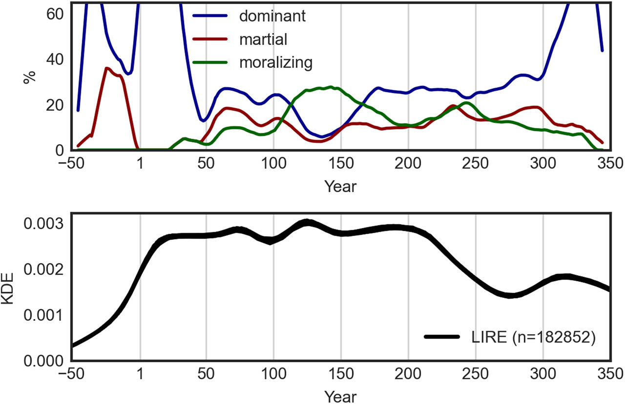
This article presents a quantitative analysis of iconographic trends in the depiction of deities in the coinage of the Roman Empire throughout the second and third centuries CE to explore temporal shifts in Roman imperial propaganda in the context of developments and pressures in affluence, prosperity, and political stability. Next to providing deeper insight into the topic of Roman imperial ideology, the article’s main objective is to test the validity of the so-called affluence hypothesis from the debate on cultural evolution. The hypothesis predicts that an increase in affluence and prosperity leads to the emergence of moralizing themes in religion. Based on the comparison of the iconographic trends in Roman coinage, as represented by the Online Coins of the Roman Empire project portal of coin types, with changes in affluence and prosperity indicators for the period of the second and third centuries CE, the results suggest that in times of political stability and prosperity, Roman Empire emphasized moralizing deities on coins more often than in times of crisis. In contrast, martial deities and those oriented on dominating power were promoted on coins more frequently in turbulent times. In this small-scale case study, the results support the arguments of the affluence hypothesis.
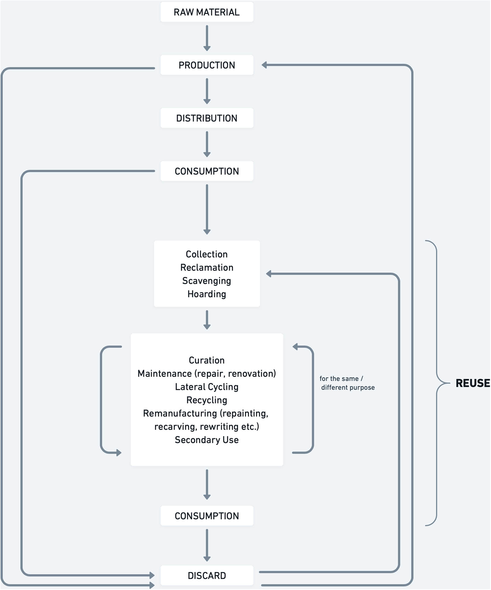
In recent years, studies on reuse practices in premodern societies have multiplied. Nonetheless, a linear model (production – usage – discard) is still widely employed for describing past economic systems. Integrating it with a circular model, instead of assuming that products were discarded after their usage, would greatly benefit our knowledge of ancient and medieval economies. In this work, we present a model of circular economy and define the terms used in this context. Thereafter, a possible agenda on how to study circularity both through archaeological material and written sources is traced. This covers archaeological fieldwork methods, as well as the process of interpretation and the re-evaluation of old data. It also proposes new strategies to use and read written sources to explore reuse practices. If different theoretical and methodological approaches are combined, a more holistic and vivid picture of premodern economies can be gained and help our understanding of how past societies used the resources available to them.
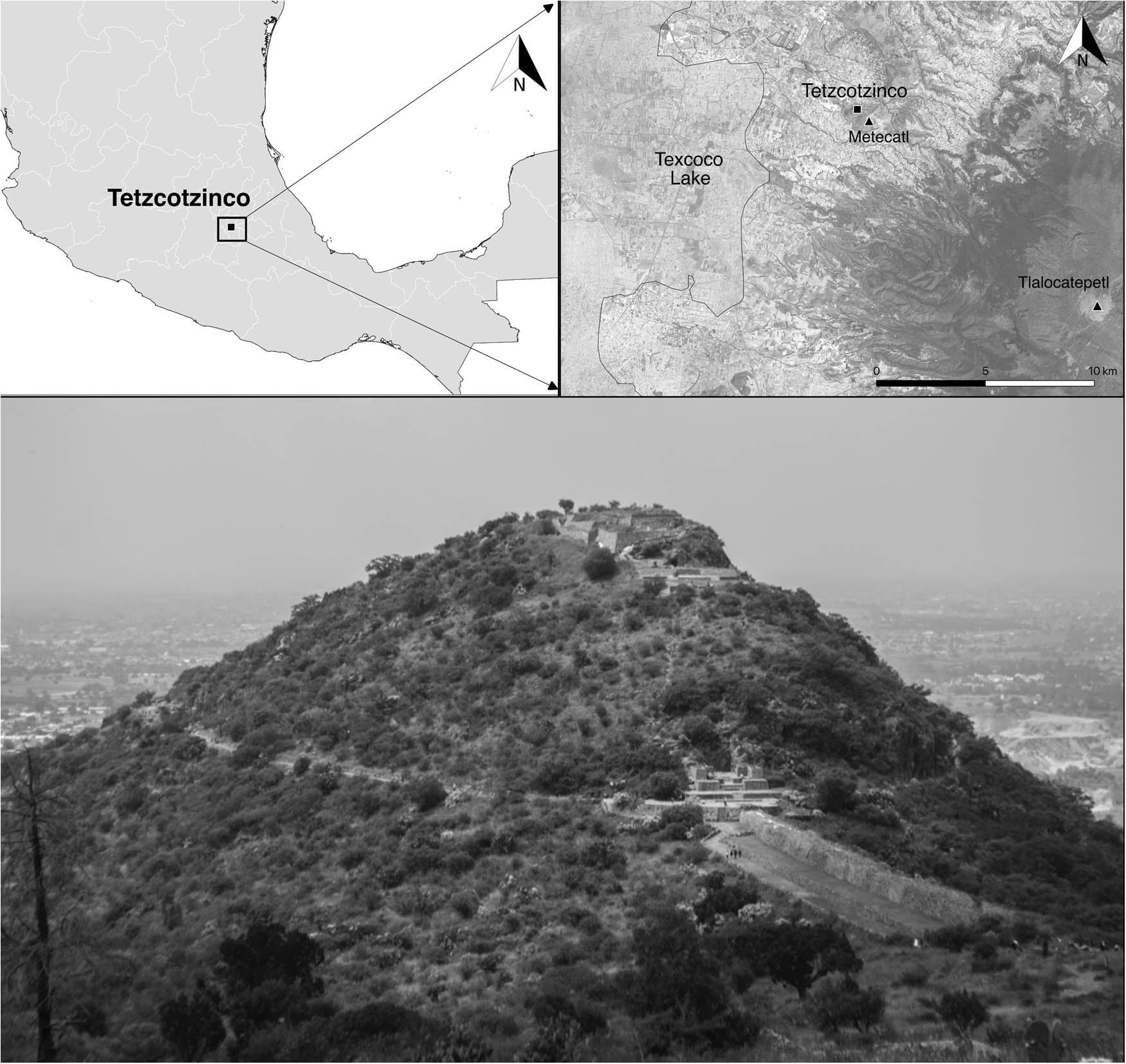
This work presents the results of new archaeological research carried out in Tetzcotzinco, Mexico, with a special focus on its water management. Survey documentation at the site, with the use of 3D photogrammetry, offered new images and maps of water control features, namely, canals, reservoirs, and aqueducts. The integration of these data into a GIS database, as well as the complementation of information from previous archaeological research and colonial historical accounts, allowed further analysis of the flow, velocity, and quantity of water distributed at the site, and its possible connections with watercourses in its surroundings. This research studies the broader regional water sources and three possible courses of water in the area which could have provided the flow of liquid into Tetzcotzinco. This article is a contribution to a better understanding of the importance of water and its distribution not only in Tetzcotzinco but also in the Center of Mexico during pre-Hispanic times.
We present an interdisciplinary collaboration whereby linguistic data are explored with the aim of gaining new insights on archaeological features to enrich investigations of the past. Archaeology on its own relies on a very discontinuous record and here we argue that a fuller use of linguistic resources can offer more nuanced insights of the cultural context, and thus a more comprehensive reconstruction of both archaeological histories in general and archaeological features specifically. Languages, as complex human artefacts, often develop vocabularies that reflect speakers’ need to communicate about everyday objects and actions. Therefore, it makes sense to turn to lexicographic and semantic data as sources of additional clues about various aspects of the past. To date, this kind of collaboration has either focused on aspects of culture that leave little trace in the archaeological record or on aspects of material culture that informs wider histories of migrations and contacts. Collaboration has also, more often than not, had the goal of answering linguistic rather than archaeological questions. The novel approach we propose here is a focus on a domain which does leave a substantial trace in the archaeological record and that falls in the realm of mundane aspects of the universal human experience – i.e. domestic fire use – with the aim of gaining a more nuanced and culturally grounded understanding of archaeological features and their investigation. This article is a demonstration in principle for the potential of this approach, illustrated here with a pilot study of combustion features on the Australian continent. Having collected fire-related words in a sample of dictionaries of Australian Indigenous languages, we explain how and why the information they encapsulate can support archaeological studies.
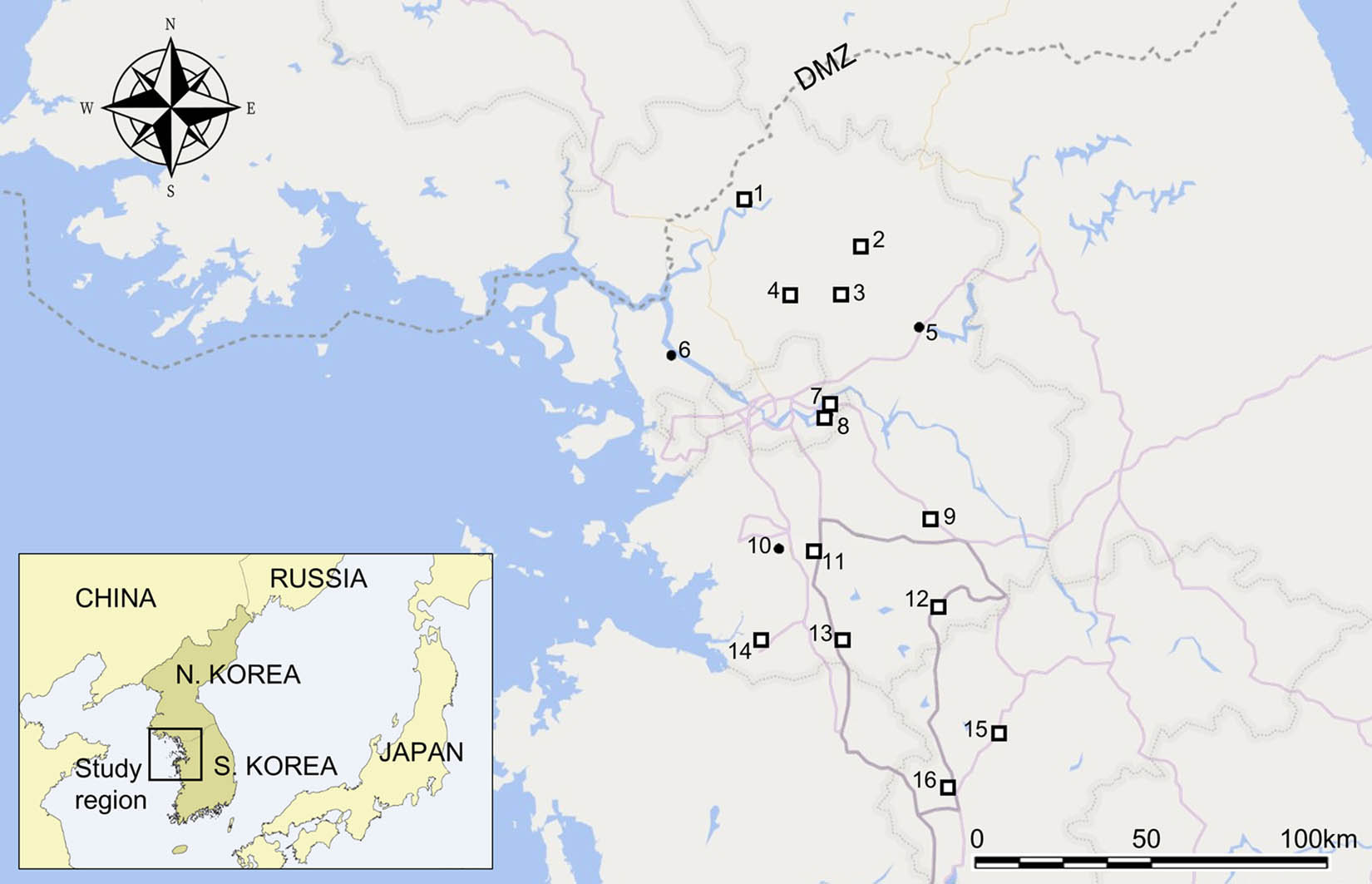
The process of state formation is a social phenomenon closely connected with a polity’s external relationships. During peer–polity interactions, polities undergo social reorganization as they mutually influence each other. This study examines this process and argues that in central-western Korea, around 200–400 CE, hostile interactions among multiple polities weakened the power of ingroup members to level social differences and increased social complexity. When confronted with unfriendly outgroups, potential rulers could assume different social roles (e.g., diplomat, war leader, or trader) and utilize new social threats to demand and legitimize higher social status. Archaeological data from central-western Korea illustrate the community’s efforts to build a defense system and prepare for war. Autonomous agricultural communities rapidly realigned into a state system in response to external threats, presumably from historically documented hostile groups such as the Lelang commandery and Goguryeo. The decision to oppose neighboring polities likely enhanced the leaders’ ability to consolidate power, while the rulers of the Baekje (also spelled “Paekche”) state could employ various other means for self-aggrandizement throughout its history.
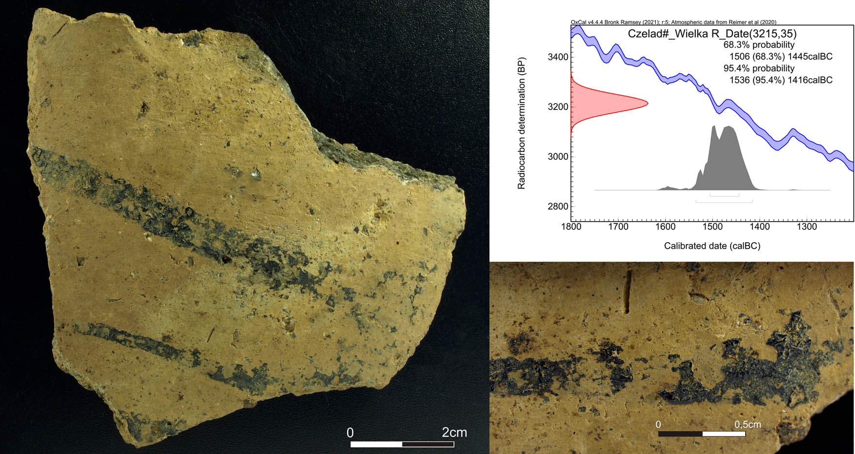
The article presents the results of research on the habitation model, chronology, and pottery production of the Silesian-Greater Poland Tumulus Culture at Czeladź Wielka settlement (Góra county). The site of the Czeladź Wielka is the first published settlement of the Tumulus culture from the area, providing the first evidence for developing a model of habitation change between the Early and Late Bronze Age. The typochronological analyses allowed positioning the finds in the Middle Bronze Age, while radiocarbon dating placed the site between the late sixteenth and fifteenth century BC. Quantification of technological traits were used to define the general characteristics of Tumulus culture pottery in the region showing the preference for coarse, undecorated, or textile-impressed ceramics. Spatial analyses indicate the presence of a clustered settlement pattern characterized by discard of ceramic material in cultural layer. The findings suggest continuity of certain cultural traits from the preceding Únětice and the influence of contemporary Trzciniec cultural circle.
While archaeology is certainly a politically conscious discipline, with various members involved in political and activist movements, especially focusing on gender and race issues, little has been said, discussed, or done with regards to class and elitism. In fact, it seems that since the advent of postmodernity in the 1970s, class and elitism have become moot topics. The aim of this article is to reflect upon class-based discrimination and elitism in archaeology, first by tracing the changes they have undergone, especially during late capitalist times, and how class has become sublimated to fit the neoliberal agenda; second, the article focuses on several issues concerning class and elitism in the university context in general, and in archaeology in particular, and how these serve as barriers to those less wealthy and fortunate; third, this work highlights how these issues concerning class and elitism in archaeology then affect scientific discourse on one hand, which has become more technologically advanced, and consequently more expensive, and archaeological theory on the other, which in its hectic search for novelty has lost its capacity to truly contribute anything new to our understanding of past and present societies.
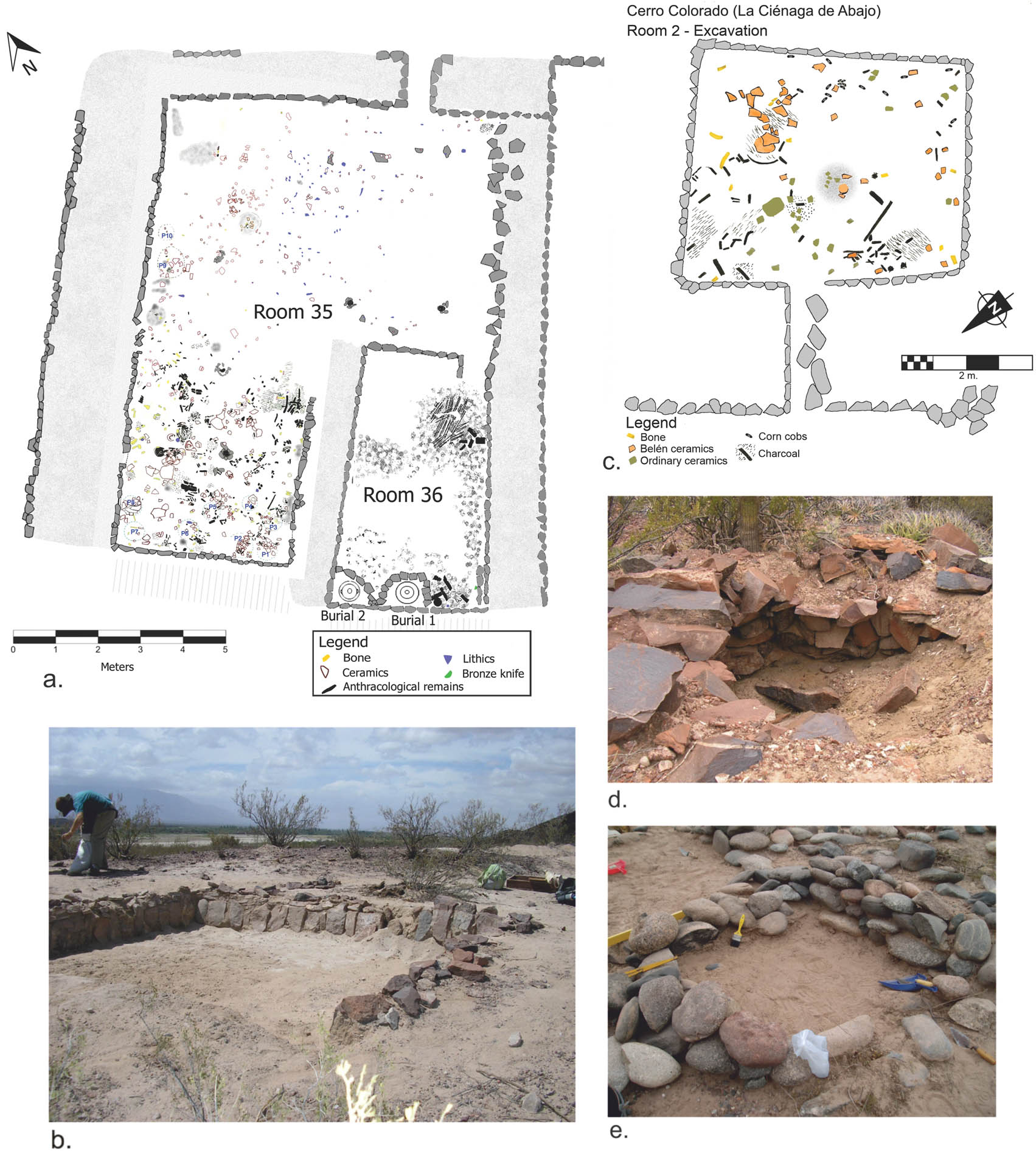
As seen in many examples of imperial expansions throughout history, the Inkas applied a whole range of policies strategically adapted for the different local organizations, in every corner of their empire, and local groups, in turn, were reconfigured based on the new conditions. Starting from the investigation of a group of late local landscapes of the Hualfín Valley (Department of Belén, Catamarca) in the Northwestern Argentina, from a critical perspective of the sociopolitical definitions classically given to these societies, the aim of this study consists of describing the spatial, social, and temporal dimensions of these landscapes and advancing the discussion about how local groups socially and politically organized themselves, in immediately pre-Inka times and after the incorporation of their territories into the Inka state. To this end, a brief discussion on the Late and Inka periods in Northwestern Argentina and theoretical guidelines for landscape analysis are presented. Then, we address the analysis of one of the landscapes in particular: the Cerro Colorado de La Ciénaga de Abajo and its surroundings, and we briefly analyze the cases of Asampay, Palo Blanco, and Puerta de Corral Quemado, and the regional landscape network.
This study examines the role of the Nuragic metal trade in the Mediterranean setting, seeking to advance the debate on this subject. Published metal-related data are considered alongside current interpretations. Although Sardinia is geologically rich in metals, including copper and lead (silver), scholars have nonetheless disagreed about the role of these metals in shaping the political economy of Nuragic Sardinia and its interaction with the outside world (c. 1350–720 BC). Traditionally the island has been seen as passively relying on the agency of foreign merchants from the eastern Mediterranean region. Lately, however, a divergent view has credited Sardinia with a more active and autonomous role in the Mediterranean marketplace. This study provides an analytical review of the complexity of such opinions, alongside isotope-derived and other archaeometallurgical evidence. As a scaffold for future inquiries, key features based on theoretical and historical perspectives are pulled together to form an exploratory model of Sardinia’s changing geopolitical position in the interlinked world of the Mediterranean between the Bronze and Iron Ages. The time around 1200 BC is identified as a major historical threshold.
Sites from the earliest known phases of Maltese prehistory often consist of scatters of sherds for the Għar Dalam and Skorba phases (6000–4800 BCE), and tomb contexts for the Żebbuġ phase (3800–3600 BCE). Neolithic studies are, therefore, heavily reliant on the study of pottery. Although traditional typological and seriation-based analyses of the pottery record have substantially enhanced our knowledge of Early Neolithic Malta, there is a growing appreciation of the need to go beyond these approaches to gain new insights. This study reviews the accessible literature on fabric studies on assemblages found in the Maltese Islands, presenting the state of knowledge for the pottery of the Għar Dalam, Skorba (Early Neolithic), and Żebbuġ (Late Neolithic) phases. Microphotographs of pottery wares were selected from a compilation produced for an ongoing project (the MaltaPot project) to illustrate the descriptions found in the literature. The advances made by archaeologists in studying the Maltese Neolithic pottery are reviewed, and suggestions for building on them are proposed, as archaeometric and petrographic techniques have not been applied systematically to Neolithic pottery from Malta.
The spectacular finds at Turkey’s Göbekli Tepe have fired the imaginations of archaeologists and the general public alike. Reflecting on developments at and about the site since the 2011 publication of a critique of the site’s dominant interpretation as a hunter-gatherer cult centre, this article shows that some elements of that critique, including assertions about roofing and a residential population, have gained traction, while others have fallen on deaf ears. Göbekli Tepe has also become the locus of discussion and speculation in disciplines ranging from astronomy and religion to psychology and architectural history, while also inspiring pseudoscientific claims that associate the site with the Garden of Eden, a supposed technologically sophisticated pre-Holocene civilization or extraterrestrial visitors.
Special Issue Published in Cooperation with Meso’2020 – Tenth International Conference on the Mesolithic in Europe, edited by Thomas Perrin, Benjamin Marquebielle, Sylvie Philibert, and Nicolas Valdeyron - Part II
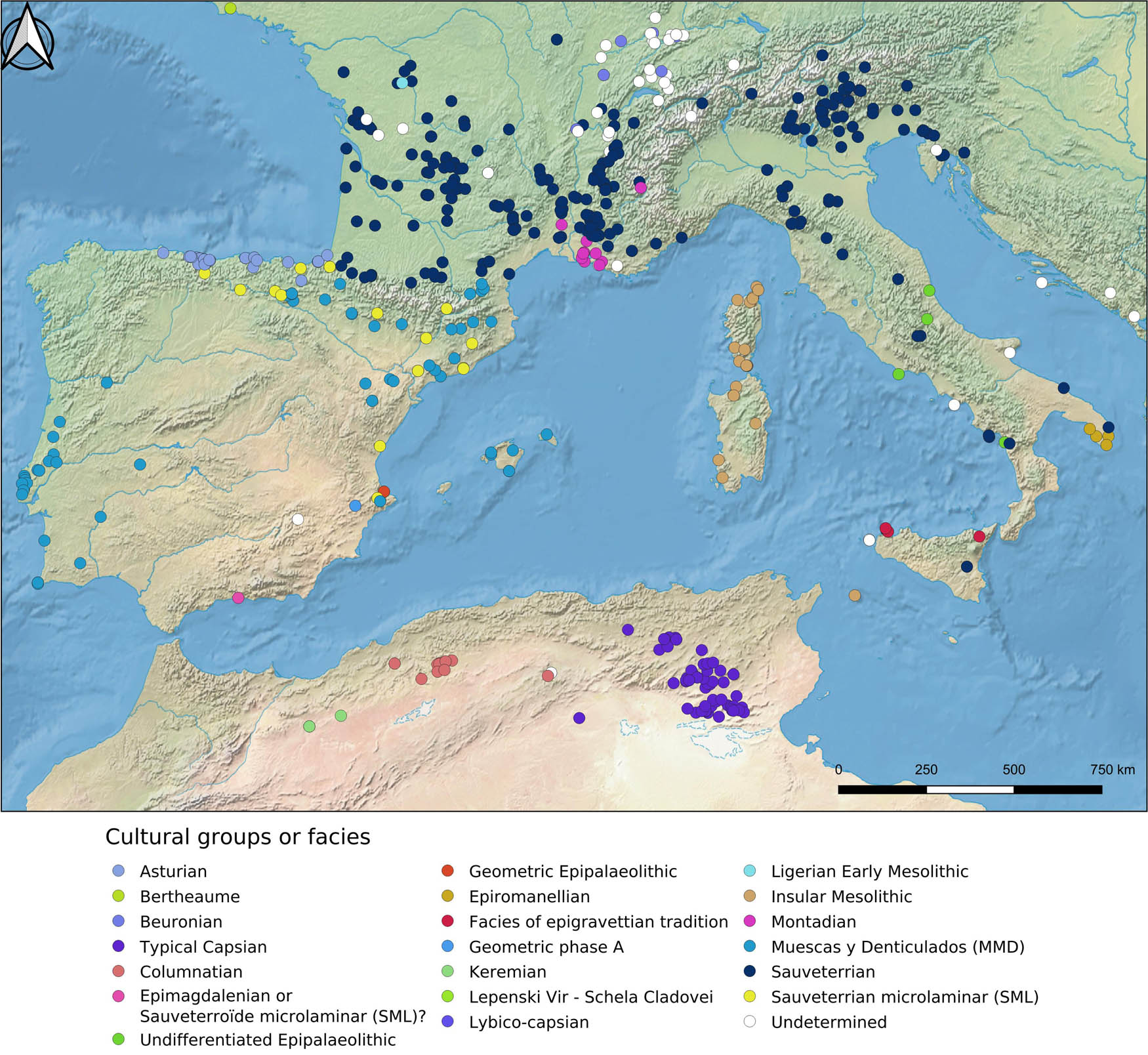
In the Western Mediterranean Basin, the last hunter-gatherer societies fall within a chronological range between the 9th and 5th millennia cal. BCE, that is, between the cold oscillation of the Younger Dryas and the Holocene climatic optimum, before disappearing under the expansion of the first Neolithic societies. The variability in cultural expressions is very high, as shown by the variability in the lithic industries, a technical field which, from a historiographical point of view, is the preferred approach of archaeologists to address these issues. However, convergences in technical choices or typological features show the existence of major currents of diffusion and exchange between many of these Mesolithic groups. But the discussion of these cultural dynamics requires knowing precisely the absolute chronology of these groups and the detailed characteristics of their material productions. The aim of this article is so to re-examine the chronocultural organization of the Mesolithic of the Western Mediterranean, especially the first part of it, roughly from the middle of the 10th millennium cal. BCE to the middle of the 6th, on the basis of a critical revision of the absolute dates.
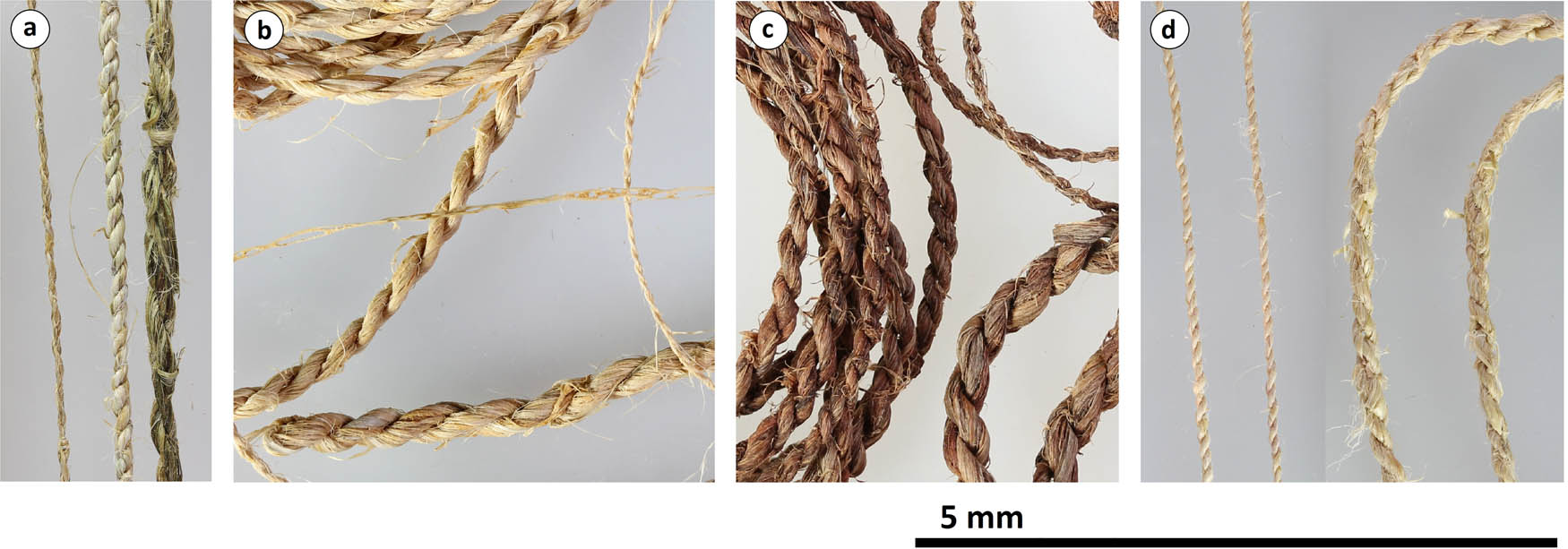
The site Zamostje 2, located in Sergiev-Posad district of Moscow (Russia) on the west bank of the Dubna River, has provided two Mesolithic and one Early Neolithic occupations dated from 7000 to 5400 cal BC. Thanks to the waterlogged environment, the site has an exceptional preservation. The site has yielded fishing screens, fishing fences, wooden fishing traps, and several small cordage remains elaborated with plant fibres, pine bark floats, fragments of paddles, and other wooden objects. In this work, we present the study of the fragments of cordage and fishing nets with the objective of providing new insights into the production and use of implements made of plant fibres. We have characterized the production process by analysing the morphological and technical characteristics by carrying out experimentation with plant fibres in order to obtain reference material to recognize them at an archaeological level. The analysis of 82 knots and 23 fragments of strings has allowed to determine that they were elaborated with single threads from 0.5 to 1.5 mm thick, which is noticeably smaller than most examples from other sites. All of them were elaborated with woody bast fibres.
This article focuses on the Mesolithic record of northeastern Italy, one of the key European regions for studying the last prehistoric hunter-gatherer groups. Most specifically, it aims to compare the rich Early and Late Mesolithic evidence, trying to shed some light on the shift between these two periods. Such a topic is approached at a regional scale, that is to say, by comparing the overall record and trying to identify similarities and divergences concerning different aspects of past lifeways such as settlement strategies, technology, exploitation of faunal resources, ornamental traditions and burial rituals. Overall, by providing an updated regional synthesis, the presented data highlight aspects of continuity and discontinuity between these two periods and contribute significantly to the debate concerning the modalities in which this transition took place in Southern Europe.
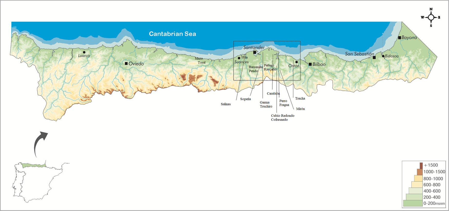
This article presents the research on the palaeoenvironmental changes that took place at the end of the Tardiglacial, in the early and middle Holocene, observed in sites of anthropic origin in central-eastern Cantabria. Through the comparative analysis of the economy, the settlement pattern, and the industries of the Azilian and Mesolithic settlements, we try to infer the repercussions they could have had on the last hunter-gatherers, in order to adapt to the modification of the territory, the change in the available resources, and the socio-economic consequences they could have had on the settlement. The radiocarbon record of central-eastern Cantabria and the Cantabrian region (Northern Spain) between 9.5 and 7.9 ka cal BP is analysed in order to assess the impact of the cold events that occurred in 9.3 and 8.2 ka cal BP, identified in the palaeoenvironment.
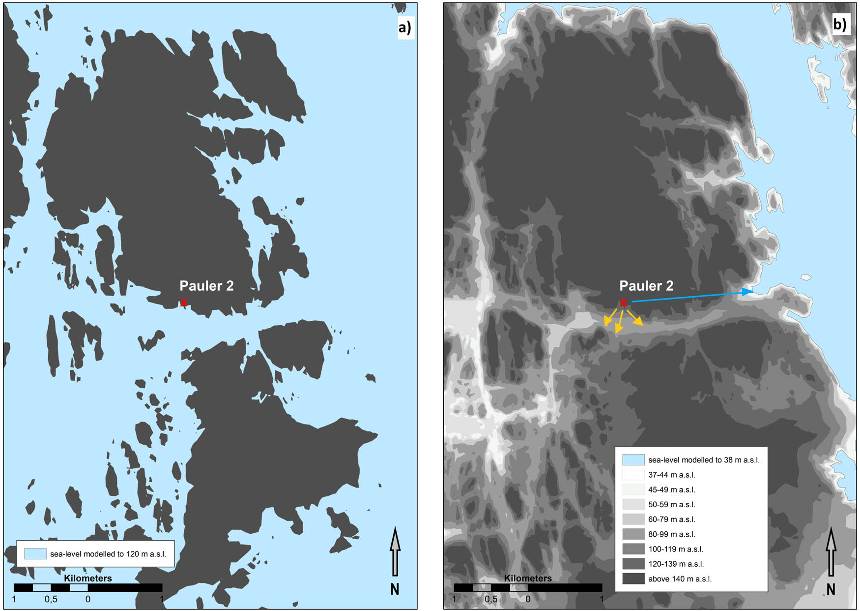
The coastal areas of Southeast Norway underwent dramatic environmental changes throughout the Mesolithic period. Continuous postglacial land uplift/isostatic rebound lead to retreating shorelines turning former seabed into coastal hinterland. While archaeological research lately has focused on the coastal and marine orientation of Mesolithic groups in the region, their interaction with the wooded coastal hinterland is little researched. This article explores shifting human–environment relations connected to these long-term changes. The starting points are nine archaeological sites in the Oslo fjord region, from which the artefact material shows that they were coast based in the earlier Mesolithic. They all have yielded radiocarbon dates from structures, mostly hearths, with later Mesolithic datings. At these later times, the sites had turned into elevated hinterland locations. First, the archaeological context and sample material of these later dates are discussed; on this basis, it is suggested that these later dates, earlier interpreted as impaction of forest fires, indicate the use of elevated hinterland locations in the Mesolithic. Second, this article explores the relevance of the wooded hinterland for the Mesolithic groups of the region, including animated beings, wayfinding practices and the possible function of these hinterland locations as potential practical and cosmological anchor points and strategic points in a communication system. It is argued that the study of the use of the hunter-fisher-gatherers’ interaction with the wooded and rocky coastal hinterland is needed to achieve a holistic understanding of their involvement and socializing with their world.
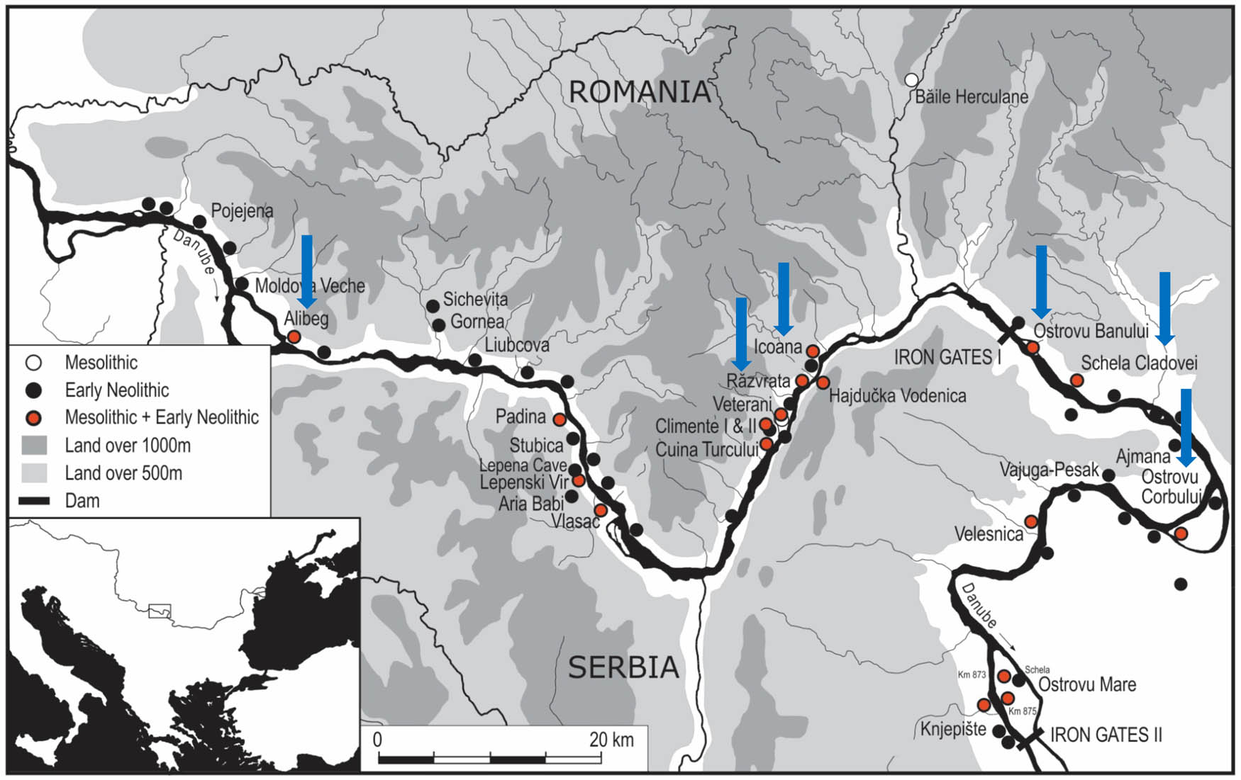
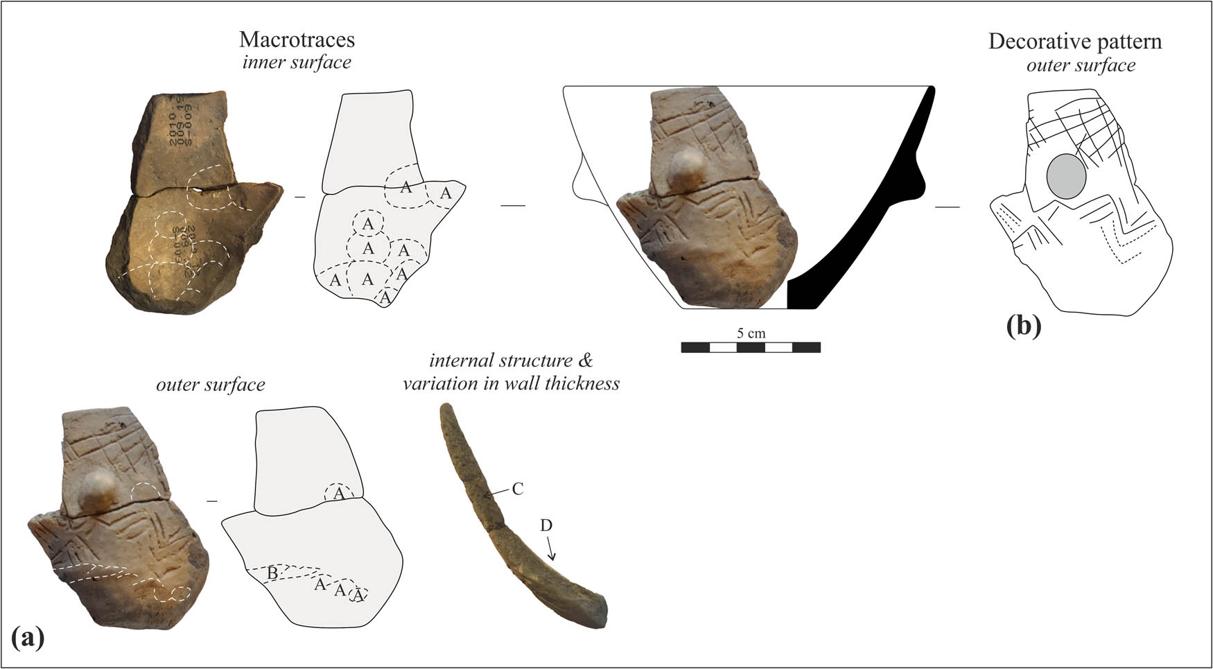
The Mesolithic settlements on the left bank of the Danube in the Iron Gates have yielded numerous artefacts made of osseous materials. Products and sub-products of the chaîne opératoire are present, suggesting in situ manufacturing of the finished items. Among a restricted range of artefact types, the most characteristic ones are bevelled tools made of antler, pointed tools of bone, and boar tusk scrapers. Our research has focused on identifying both the manufacturing processes applied to the various raw materials and the marks left by use, which are key indicators of the function of the artefacts. We were also interested to know if a unitary technological scheme could be identified throughout the Iron Gates, or if there are features specific to individual sites. Our findings suggest that despite a general unitary pattern, it is nevertheless possible to identify elements that are characteristic of individual sites but whether these were the result of economic or cultural factors is more difficult to assess. The results of this combined approach suggest wood processing and hunting were among the main activities performed with osseous artefacts. Contrary to some previous interpretations, there is no evidence for their use in connection with plant cultivation.
This article presents a critical review of the way inland navigation is constructed in the archaeological literature as an essential component of mobility in Mesolithic Ireland, with a particular focus on boats and rivers. Against a scarce background of direct archaeological and environmental evidence, a content analysis of the academic discourse highlights a dominant processual approach structured around three themes: seafaring and pioneering “events”; boat technology and performance; broad generalisations about the land- and waterscape. It is argued that such a narrative could be usefully revisited by adopting a small-scale, high-resolution approach that would explore human and material agency and integrate analogy as a method.
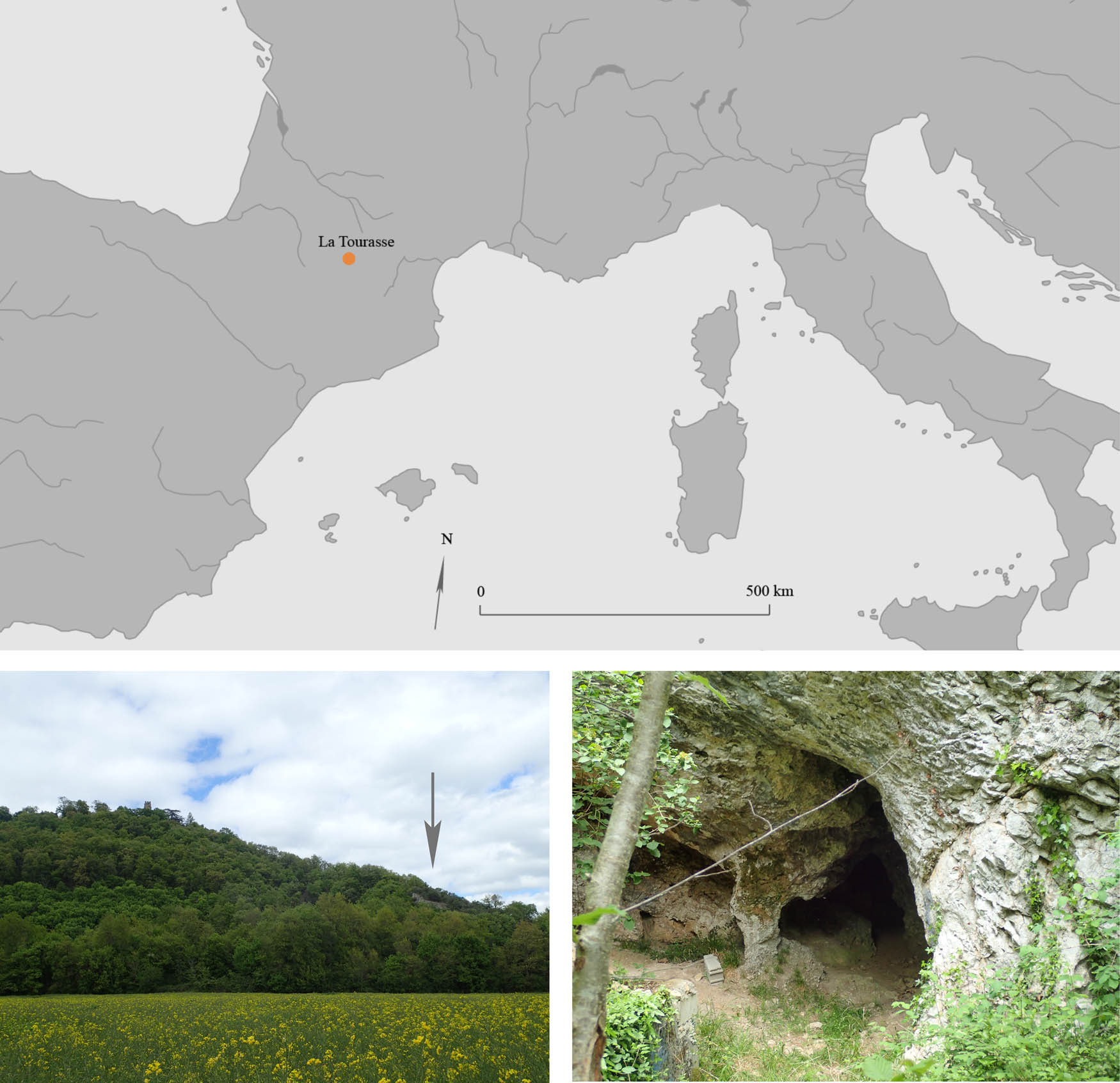
The aim of this study is to present new data on vegetation dynamics and plant collecting practices during the Late Glacial and the Early Holocene in southwestern France. La Tourasse cave is located in the Pyrenean piedmont plain, where the Azilian cultural complex was initially defined. The last excavations of the site took place in the 1980s and 1990s and the recovered materials are currently being studied or revisited from a multidisciplinary perspective. We present here the results of the charcoal analysis performed on La Tourasse’s Azilian (ca. 13000–11500 cal. BP) and Mesolithic (ca. 10500–9000 cal. BP) levels, complemented by the study of a small seed assemblage. Our results document the shift from an open landscape towards a forested environment, with the gradual passage from open vegetation dominated by shrubs of the Rose family ( Prunus spp.) to the mixed oak forest, which speaks in favor of the biochronological coherence of this sequence. However, marked differences in taxonomic richness and state of the wood from one level to another, unrelated to the prevailing environmental conditions, suggest variable behavior of humans toward wood that could be the result of differing mobility strategies, hearth functionalities, or taxonomic preferences.
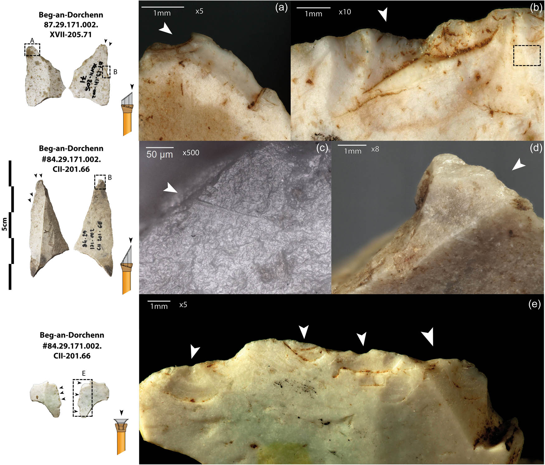
The notion of style has been the subject of much research and theoretical development in prehistoric archaeology. This vast concept touches several fields, including the morphology of artefacts, technical gestures and their function. The lithic typology of arrowhead armatures was widely developed in the twentieth century for the study of the French Mesolithic and includes some of these aspects. The functional, technical, or aesthetic nature of the morphological characteristics of these artefacts has received little attention, while the mapping of types has been overvalued This article presents a new approach combining statistical analysis with the use-wear analysis of arrowhead from several Breton sites, dated to the Late Mesolithic.
The Mesolithic technology in Western Europe depicts the last cultural expressions and adaptations of hunter-gatherers before the adoption of Neolithic agro-pastoral practices. Many questions arise when investigating the timing, nature, and historical significance of the Mesolithic. The development of the Mesolithic culture is usually associated with the onset of milder environmental conditions at the beginning of the Holocene. Hunter-gatherer societies would have adopted new subsistence and territorial strategies in response to environmental changes, which would have consecutively impacted their technological system. This assertion considers the Mesolithic in South-western Europe as one homogeneous phenomenon and eludes the putative role that early Holocene climatic fluctuations may have played in hunter-gatherer organizations. In this study, we aimed at questioning the archaeological variability of the first Mesolithic by taking benefit from new data provided by recent excavations at La Baume de Monthiver (Comps-sur-Artuby, France). La Baume de Monthiver is a small rock shelter located along the Jabron Valley in the southern French pre-Alps. The rock shelter records several Mesolithic occupations documenting Sauveterrian technological traditions. By studying the Baume de Monthiver, we take the opportunity to explore the Sauveterrian in its longue durée and address the question of its diachronic variability. In this study, we investigated the M-B′ archaeological assemblage and question its homogeneity at the transition of the 10th- and 9th-millennium cal. BP. Our results document stable technological and subsistence practices before and after the climatic fluctuations at the end of the 10th-millennium cal. BP, supporting the hypothesis of well-adapted Mesolithic societies to the climatic “instability” characterizing the early Holocene.
The remarkable group of tools was detected among the hunter-gatherer-fishers’ archaeological materials of the East European Plain central part dated around 3500–2700 BC. The so-called “crooked items” were initially interpreted as ritual phallic depictions, but now after conducting a more detailed analysis of their morphology, technology, and use-wear, it became clear that we deal with pressure flakers used to process flint tools. The most astonishing fact is that the straight parallel to these tools exists, coming from the opposite side of the globe, namely, the Bering Strait region – Kamchatka, Chukotka, and Alaska, where the same tools are known quite well both in archaeological and ethnographical collections. In this study, we discuss the results of use-wear analysis of both handles and removable tips from the Central Russian settlements of Moscow, Ivanovo, and Yaroslavl regions dated the second half of the fourth to the beginning of the third millennium BC.
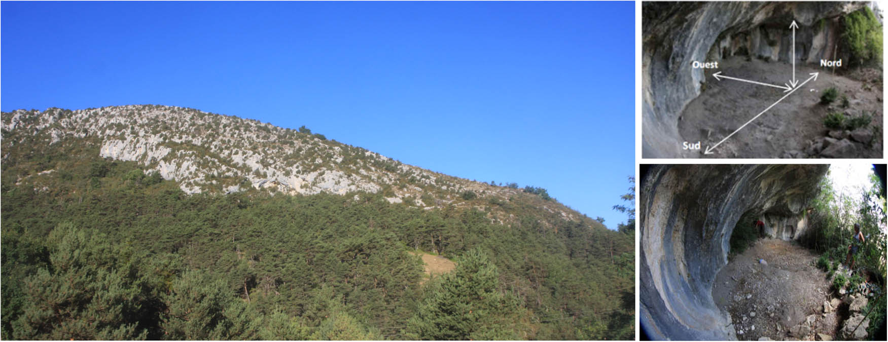
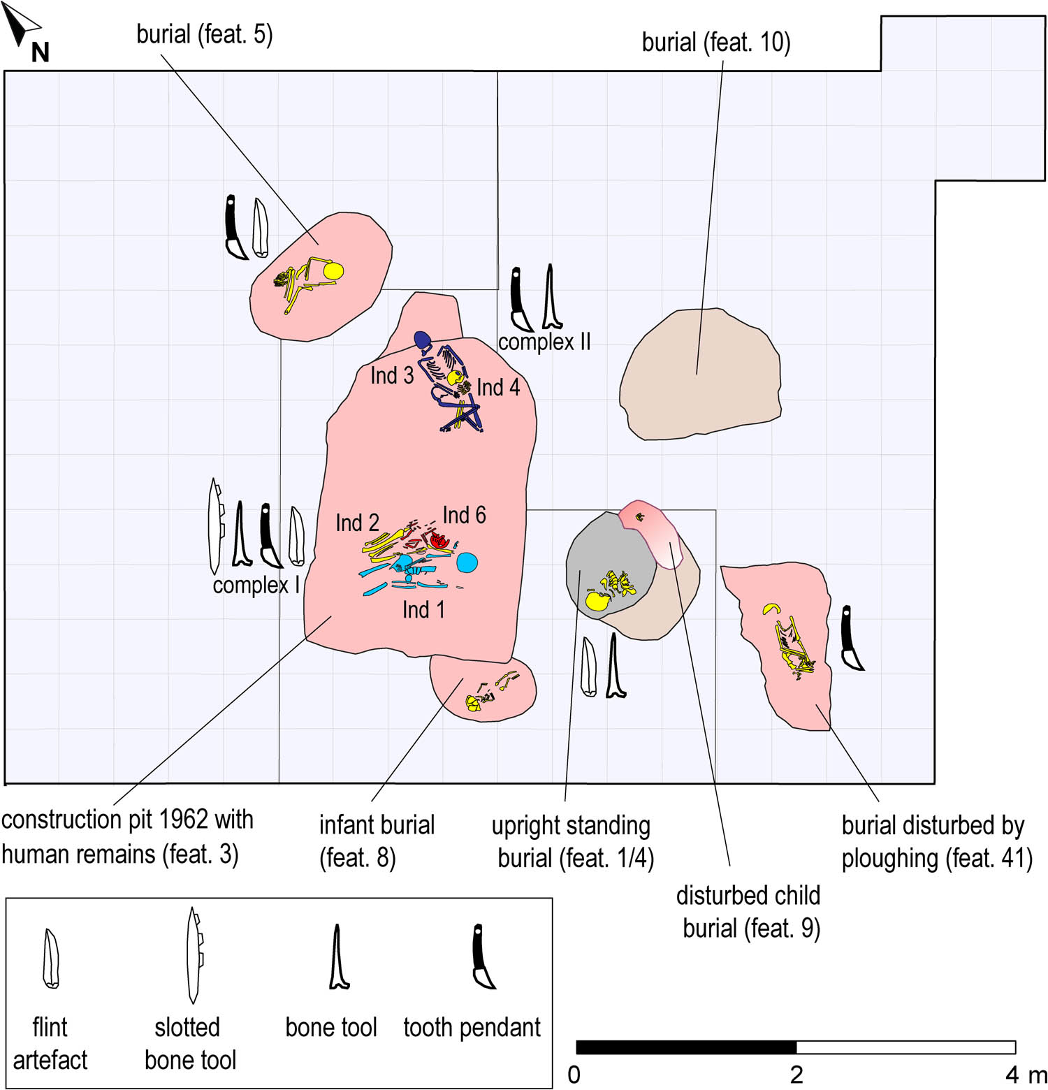
The Mesolithic burial site Groß Fredenwalde, NE-Germany, discovered in 1962, had remained a poorly understood part of the Mesolithic burial record for decades. Since 2012, the site has been under re-investigation. New discoveries confirm the presence of several single and multiple inhumation graves. Groß Fredenwalde stands out as the largest and one of the oldest Mesolithic cemeteries in North-central Europe. Its use period can be separated into two phases: a main phase in the late seventh millennium cal BC to the early sixth millennium cal BC and a later single burial c. 4900 cal BC. Here the state of research on the site is presented and selected characteristics are discussed in the context of early cemeteries of Northern and North-eastern Europe.
Special Issue on Archaeology of Migration: Moving Beyond Historical Paradigms, edited by Catharine Judson & Hagit Nol
In this article, we critically review recurrent tropes, implicit frameworks, and unexplained concepts in current research on the process of “Neolithisation” in the western part of southern Norway. Two models are on offer, as also seen elsewhere in the European research: either 1) the transition to agriculture is rapid and substantially carried by migrants, or 2) the Late Neolithic transition builds on a long history of local adaptation. After outlining these models, we scrutinise especially west Norwegian evidence, pointing out ambiguities and limitations in the material which mean that neither of the two models fit. In the final section, we consider which new questions could be asked to move beyond the current, somewhat polarised debate: Who are the actors of the transition, how are boundaries between groups created, and can the acknowledgement of the complexity of the process of ‘migration’ result in new narratives? Addressing these questions remains a fundamental challenge for archaeological migration studies as a whole.
Many Indigenous groups in North America have long-held practices of using migration and movement in response to environmental and social changes. Diasporic communities, composed of migrants maintaining significant connections to their former homelands, were likely once common in refuge areas of North America, but not always recognized by archaeologists. Many Puebloan peoples in the Northern Rio Grande region of the US Southwest used movement as a way to escape Spanish colonial control after AD 1600, yet retained connections to their homelands. This Puebloan diaspora had far-reaching consequences for Native peoples across the Southwest and neighboring regions like the Great Plains. Here, we briefly summarize how diasporas are defined globally and the ways in which these definitions could shift to help us model diasporas in North America. Using the Pueblo diaspora and a multi-generational Pueblo–Ndee (Apache) community in the Central Great Plains as example, we explore the intricacies of identifying diasporas for North America within the contexts of Indigenous resistance and adaptation.
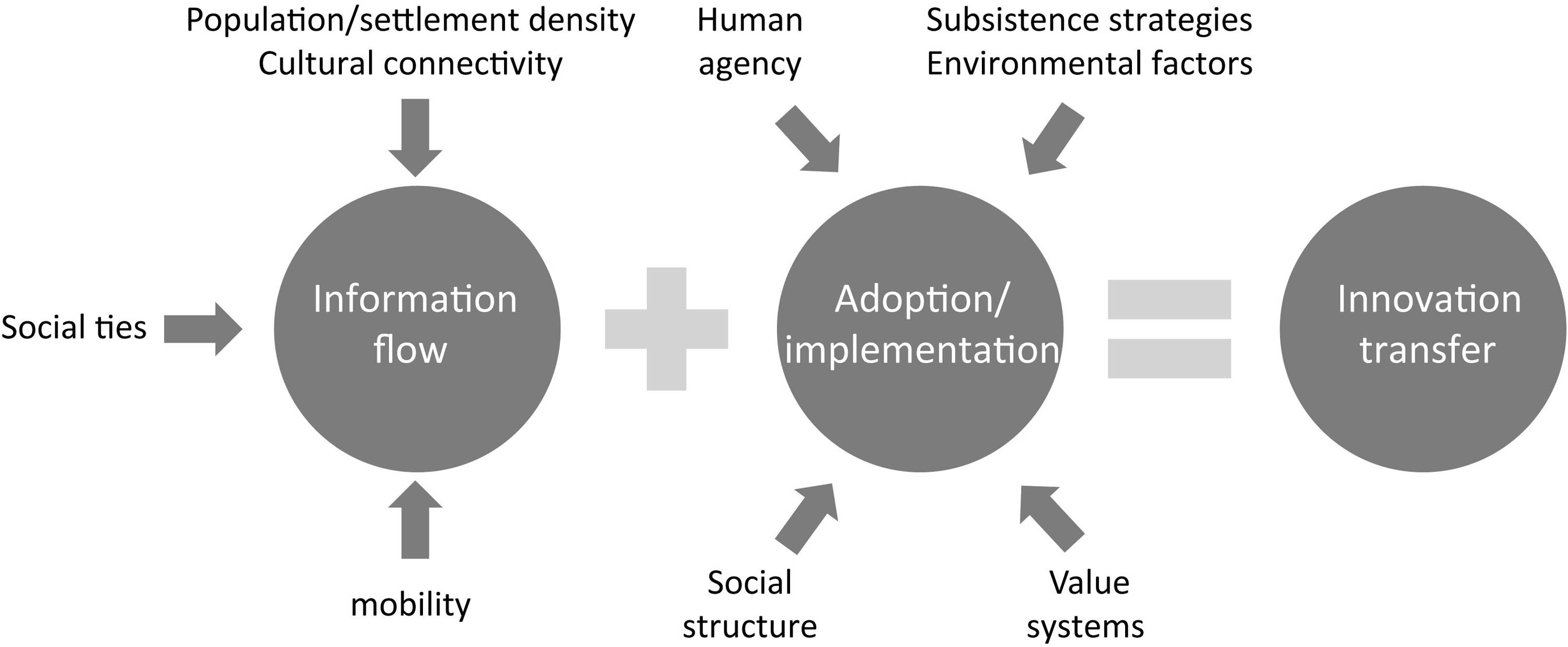
The spread of innovations is an important driver for transformation processes in human societies. It is carried by two crucial conditions – the flow of information and the adoption/appropriation of the innovation. While the latter is a social and cultural process, the first is among others carried by mobility. Mobility in this context can take on different forms and range from migration events up to small-scale everyday mobility between neighbours. In this article, the transmission of ideas and technology without major migration events will be treated. This is based on two case studies – the spread of agriculture from Central Europe to South Scandinavia and the spread of copper metallurgy from Southeast to Central Europe. For both, the spatio-temporal spread of the innovation will be described and factors influencing the information flow and the process of adoption will be taken into account. This will help to develop a more detailed understanding concerning the transmission of ideas and technology without major migration events and allows us to follow the question of what roles did mobility and other factors play in it.
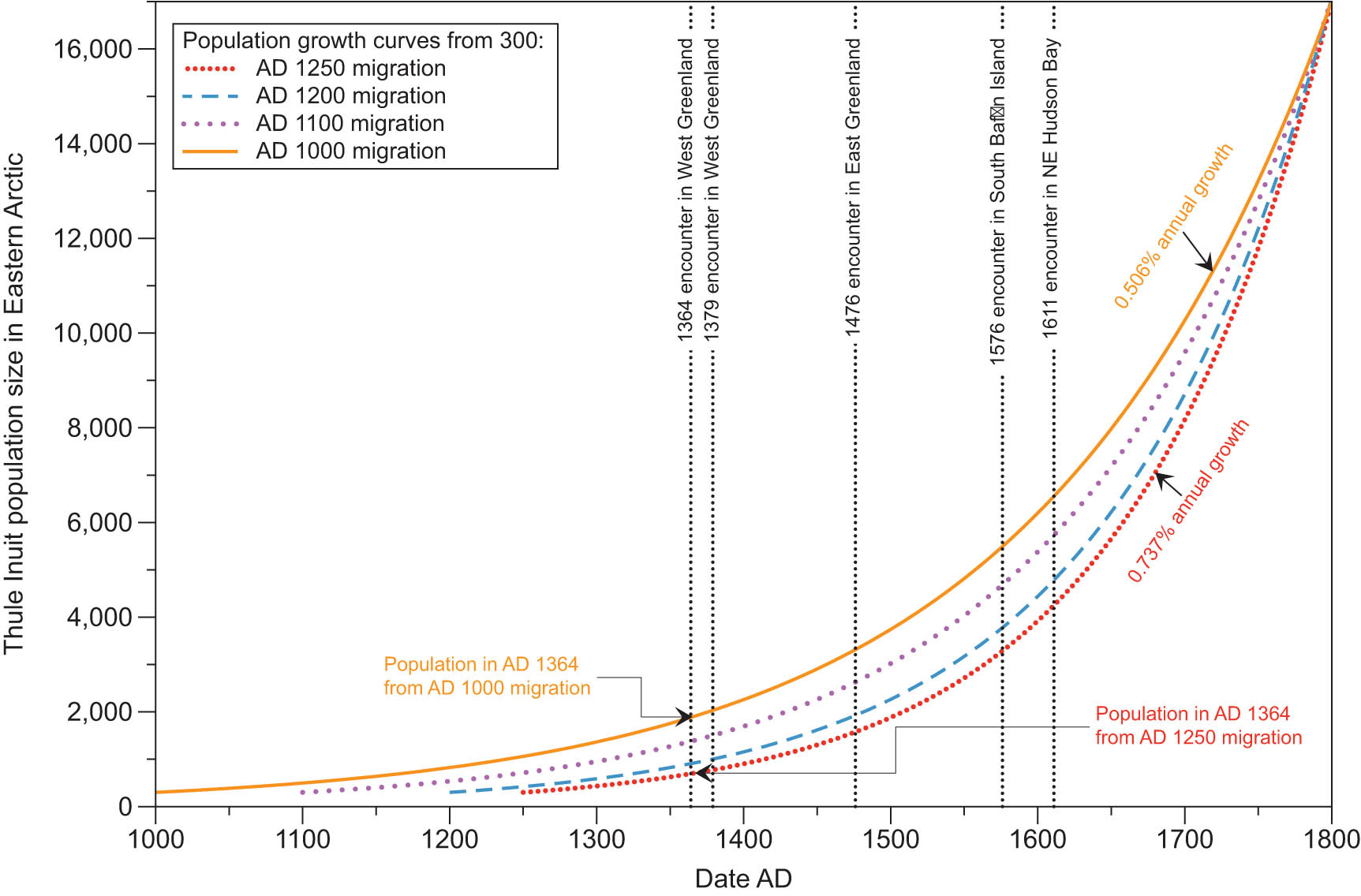
The process by which the Thule Inuit migrated from the region around Bering Strait into Arctic Canada and Greenland, which is notable for its logistical complexities, the varied and difficult regions traversed and then populated, and for the enormous distance covered, is almost invariably described in terms emphasizing the pace at which it took place. The most common description is “rapid,” and some descriptions conclude it may have been accomplished within just a few decades, despite researchers not having explored the logistical and demographic implications of that inference. This article explores several possible meanings of “rapid” in the context of the Thule migration and reviews the evidence that is informative concerning its pace, including radiocarbon dates, historical encounters, logistics, and demography. It concludes that the Thule Inuit may indeed have felt a sense of urgency to expand into new regions, but they did this at a far slower pace than most researchers have concluded, over centuries rather than decades.
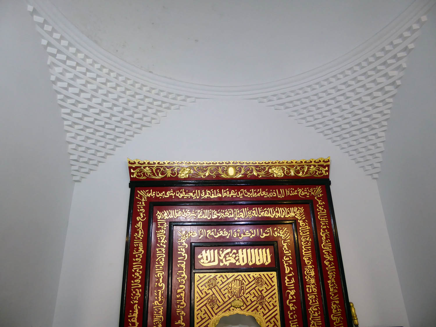
This article studies the evolution of the Muslim community in China between the fourteenth and sixteenth centuries from the perspective of mosque architecture. It analyses four medieval Chinese mosques with domed mihrab chambers: the Hangzhou Phoenix Mosque, the Songjiang Mosque, the Dingzhou Mosque, and the Qingyang Great North Mosque. The article focuses on the dome-roof of the mihrab chamber in these mosques, applying an art-historical approach to examine the construction methods, as well as the decorative details of the dome-roof. To explore the origin and function of the domes in these mosques, I compare them not only with local architecture but also architecture from Central Asia. Meanwhile, the historical text on building construction examines the links between the Muslim community and the transformation of the architecture. The appearance of the mosques’ roofs reflects the fact that the immigrant Muslims became local Muslims under the authority and conciliation of the Ming central administration.
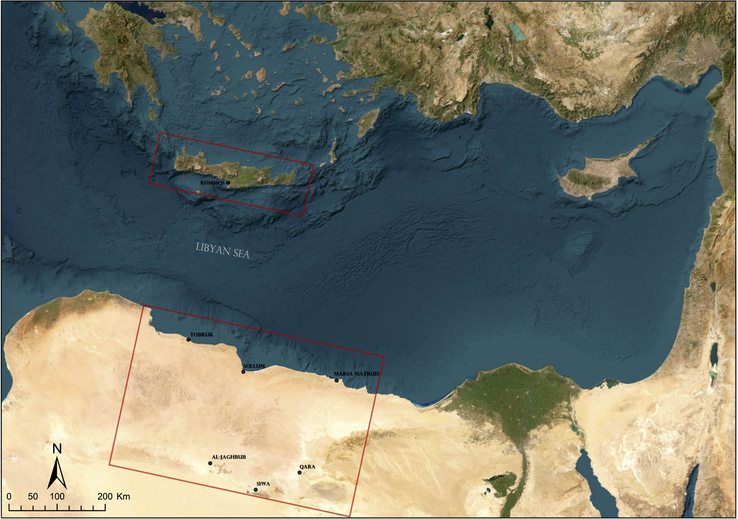
This study examines the influence of Human Ecodynamics and Historical Ecology to understand the complexities of historical mobility. Based on Landscape Archaeology, this study considers some of these theoretical principles for studying and reconstructing the movements of past human populations. This discussion is grounded on the example of a research project focused on modelling movement and interaction patterns between the Aegean area (Crete) and northeastern African region (Marmarica) from the Late Bronze to Roman times. The project works with multivariate data representative of the routes and non-human factors that may interplay in biocultural processes. Three key aspects structure this article: (1) the emergence of Human Ecodynamics and Historical Ecology in archaeology, (2) their impact on the theoretical evolution of Landscape Archaeology, and (3) the methodological implementation of these principles through a case study. We specifically discuss the strengths of Human Ecodynamics and Historical Ecology to enhance the conceptualisation of mobility by considering the heterarchical interrelationships between human and non-human agents. Our methodological implementations showcase this by using computational approaches to model human pathways influenced by and in constant relationship with their environment. This research thus highlights the importance of transdisciplinary approaches to studying historical mobility from an archaeological and complex systems perspective.
The topic of Arab migration during the medieval period has occupied many modern historians. The evidence for migration in chronicles and geographies, however, is quite thin. This article looks at these texts as well as at contemporary “archaeological texts” (inscriptions and papyri documents) and archaeology. Each of these sources provides different information under different limitations which sometimes correlates with another. One main focus of the article is the ability of archaeology to answer – alone – the question about Arab migration. For that purpose, two archaeological models are proposed. One model highlights the link between the material culture of two regions (origin and destination) in two sequent times and its evolvement in the destination. The other model points to continuous links between origin and destination and the evolvement of material culture in the origin. The models are compared to a number of case studies from the early Islamic period (seventh to tenth century AD) in the Levant, Spain, and additional regions. The case studies present innovations which might reflect migrants: irrigation methods, specific forms of architecture, production techniques of portable artifacts, and evidence for a new confession – Islam. While the archaeological records of early Islam are often too limited to answer most of the models’ criteria, two case studies seem promising: soapstone pots/bowls and early Muslim burials. Both cases imply the migration of people from the Arabian Peninsula elsewhere in the eighth or even the seventh century.
Special Issue on Ancient Cultural Routes: Past Transportations Infrastructures as a Two-Way Interaction Between Society and Environment, edited by Francesca Fulminante, Francesca Mazzilli & Franziska Engelbogen
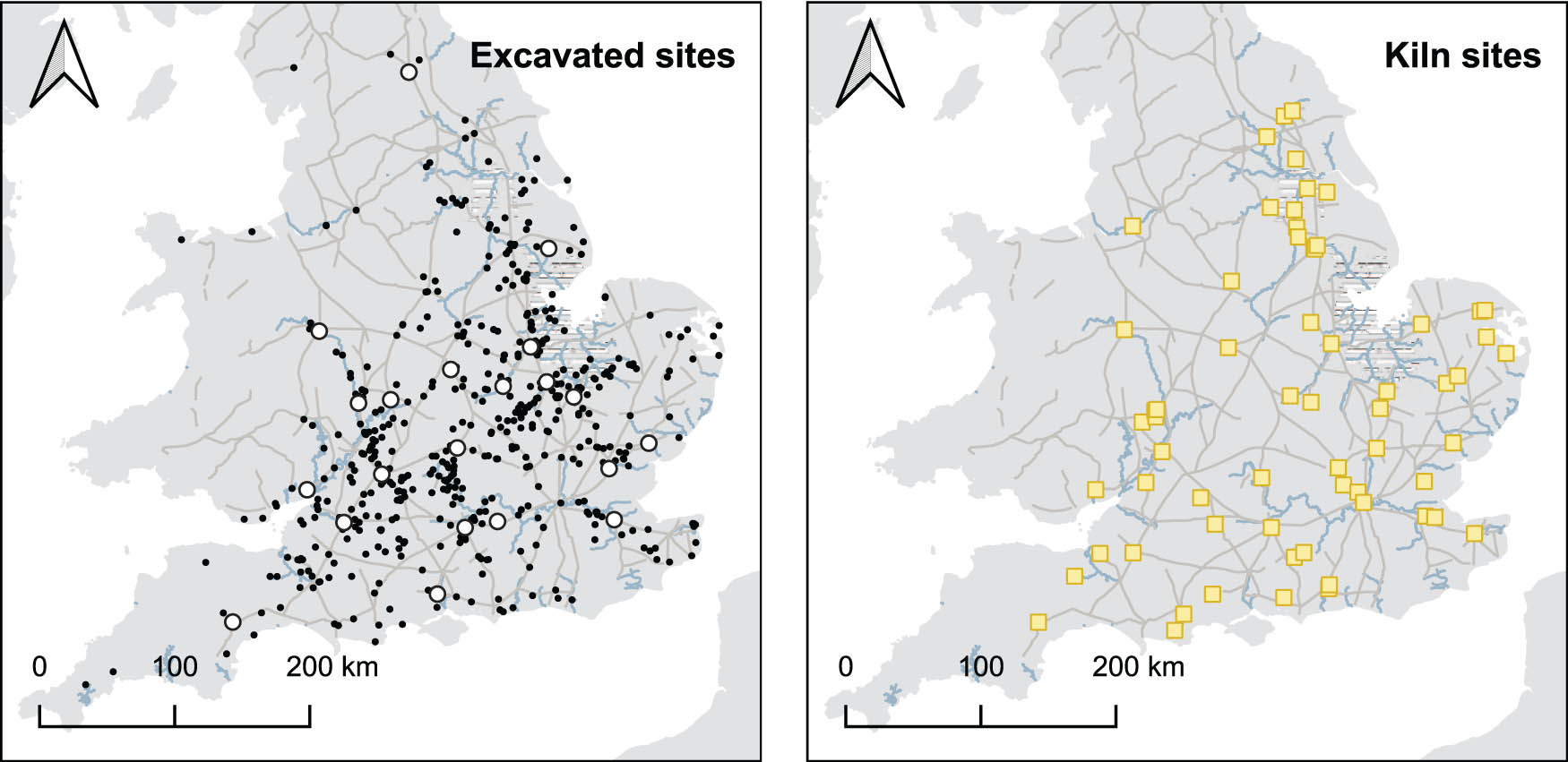
The distribution of Roman pottery depended on the transportation system which moved it. Here we trace developments in these distributions during the Roman period in Britain to document how the transportation system developed and assess its impact on the island’s economy. We created a database with records from 775 excavations at 652 sites, and data on over two million pottery sherds. By analyzing the changing distributions of pottery from production centers, we are able to measure improvements in the Roman transportation system over time. These improvements seem to have been most rapid soon after conquest, with transport costs almost halving in the first century of Roman occupation. As the road network expanded and transportation technology improved and pottery gained access to wider markets, producers’ dominance over their local markets declined as rival products became more accessible, and certain industries dramatically increased their outputs. Production by small industries fell in our Middle and Later Roman periods.
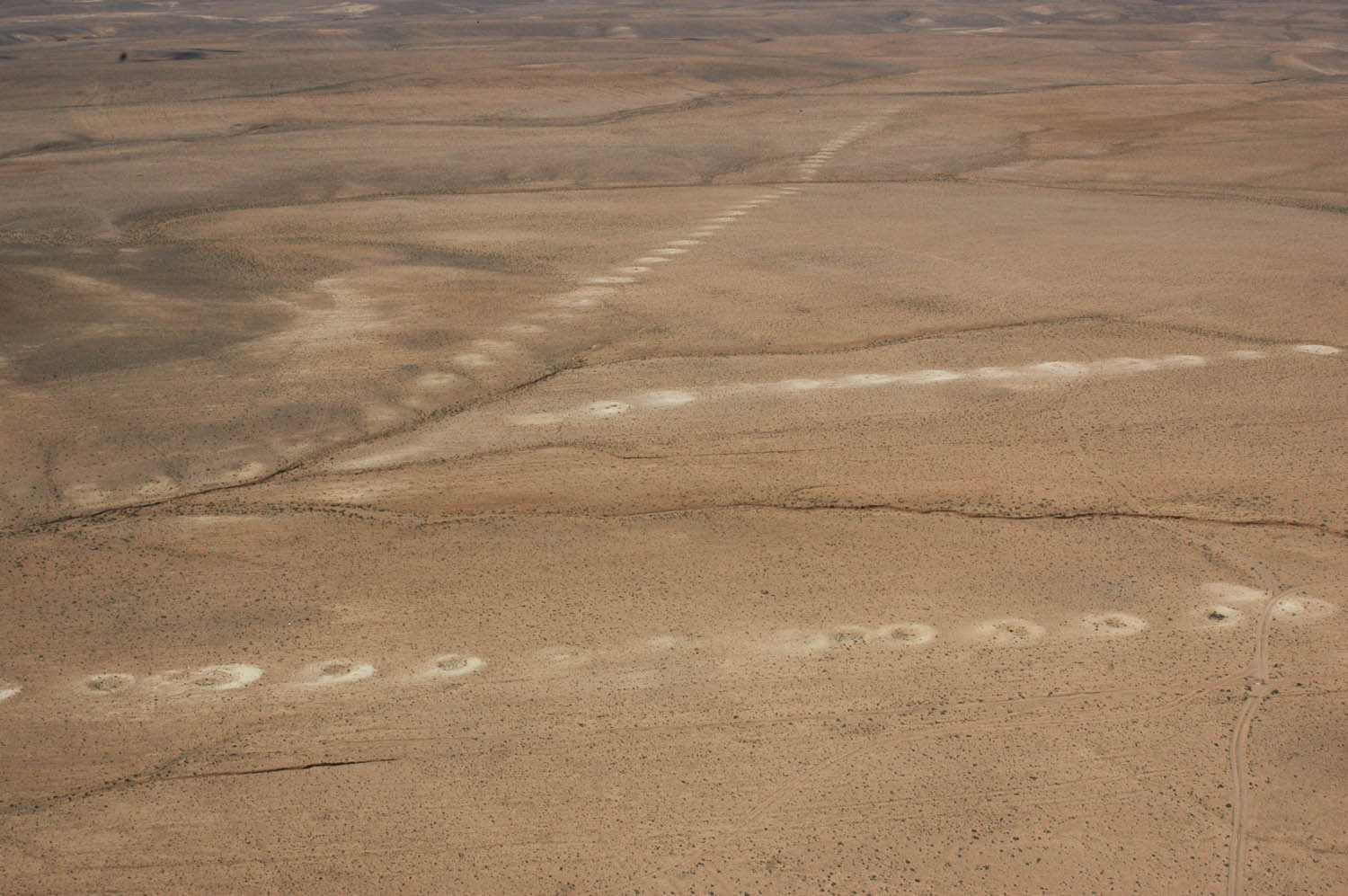
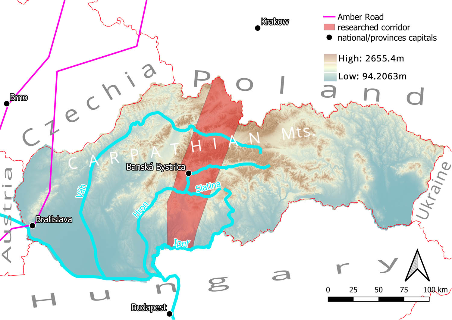
Although fertile soil is rare in central Slovakia, the region is rich in raw minerals, a resource exploited since the Palaeolithic. Maintaining trade through a reliable network of safe routes across the mountainous landscape was of vital importance, and the remains of roads that connected this mining area to the rest of the world can still be found. Furthermore, the south–north route connecting these resources with the Carpathian Basin in the south and the Vistula River Basin in the north may have played an important role as a possible bypass to the well-known Amber Road. By combining walkthrough surveys and high-resolution LiDAR data, the paths of single roads can be reconstructed and analysed in relation to the main routes. Furthermore, by applying the geographic information system-based spatial context of settlement structures, analyses can be performed on whether routes passing through certain areas caused the establishment of settlements or whether the routes were built to connect the established sites with the rest of the road network. Finally, defining ancient route planning strategies can help answer the question of how the main routes affect settlement patterns.
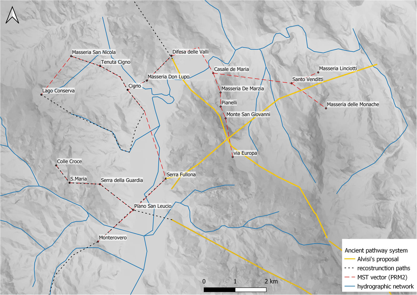
Today, the Fortore River is the geographic and administrative boundary between the regions of Molise and Apulia. In the past decade, scholars have debated Fortore’s role during the pre-Roman and Roman periods, specifically focusing on how this physical boundary may have influenced the interaction and connectivity between Samnium (modern-day Molise) and Daunia (modern-day northern Apulia). Both ancient literary sources and archaeological finds indicate the situation is complicated, and it is challenging to locate the geographical and cultural borders, especially in the pre-Roman period. This article suggests a model to understand the past interaction between the two modern-day areas of Macchia Valfortore (Molise) and Carlantino (Apulia). These sites were in the proximity of the Fortore River, and an investigation of material culture in both locations revealed a complex and diverse society between the sixth century BC and the first century BC. The small-scale spatial networks constructed help to explain the interchange dynamics between the two districts and, furthermore, how each of them related to the ancient road system. The case study demonstrates, moreover, how a not conventional archaeological approach may also highlight the prominence of river connections for economic and social development.
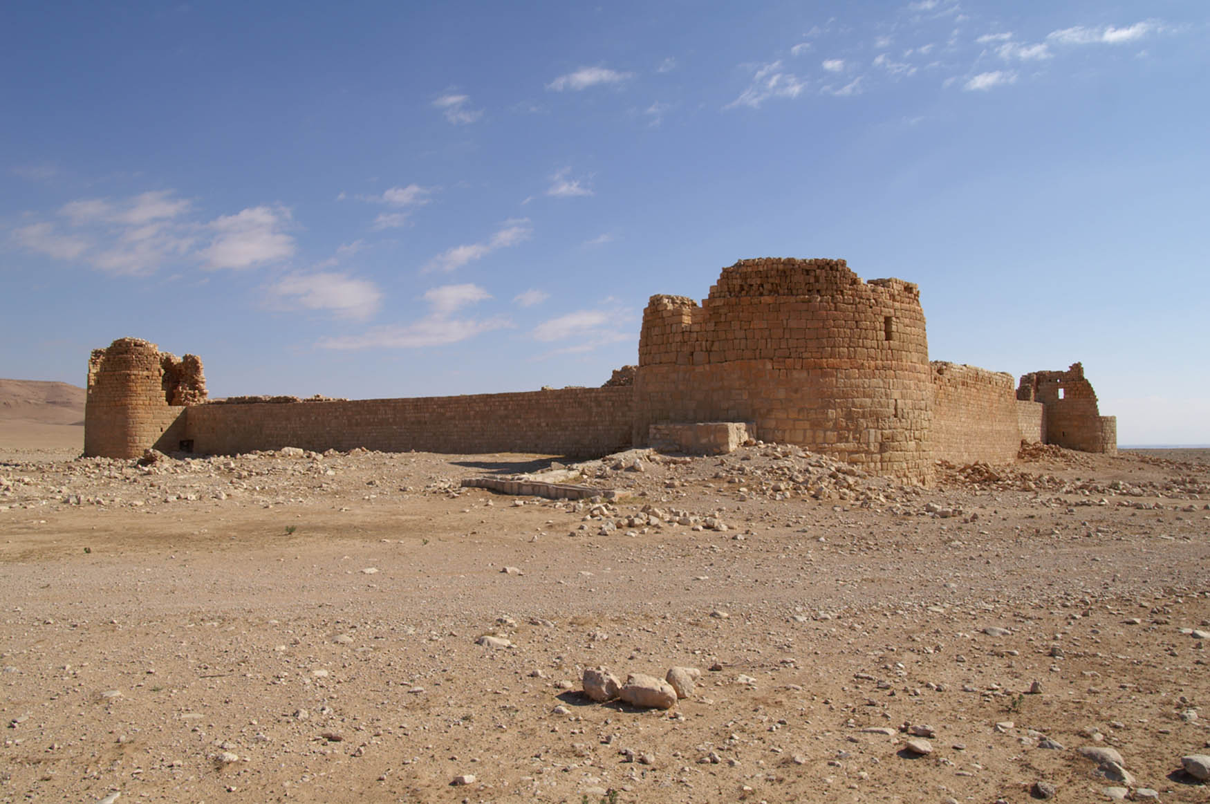
The Strata Diocletiana was a military road in Late Roman Period Syria. It ran from Damascus to the Euphrates by way of Palmyra. The road was fortified and received its name during the reign of Diocletian (284–305 CE), following the Roman sack and subsequent garrisoning of Palmyra after the city’s failed revolt 272–273 CE. The Strata Diocletiana is only one of several attested routes between Palmyra and western Syria and one of two between Palmyra and Damascus. In this study, we seek to understand why this route was chosen for the new fortified road. We compare the location of Late Roman fortifications along the Strata Diocletiana to the modern distribution of water in the Syrian Desert and the theoretical least-cost paths between Palmyra and Damascus, and Palmyra and the fortress of Sura on the Euphrates. The argument is made that some parts of the Roman road network in the Syrian Desert were planned in order to control major water sources along the desert rim, but that the new military road between Damascus and Palmyra in the late third century CE was constructed with the aim of monitoring and controlling access to settled regions from the desert, in addition to ease and speed of communication. The conclusions have bearings not only on our understanding of the Late Roman defence and communication system, but also on nomad-settled interaction in Late Antiquity and the use of GIS methodologies in the reconstruction of ancient communication networks.
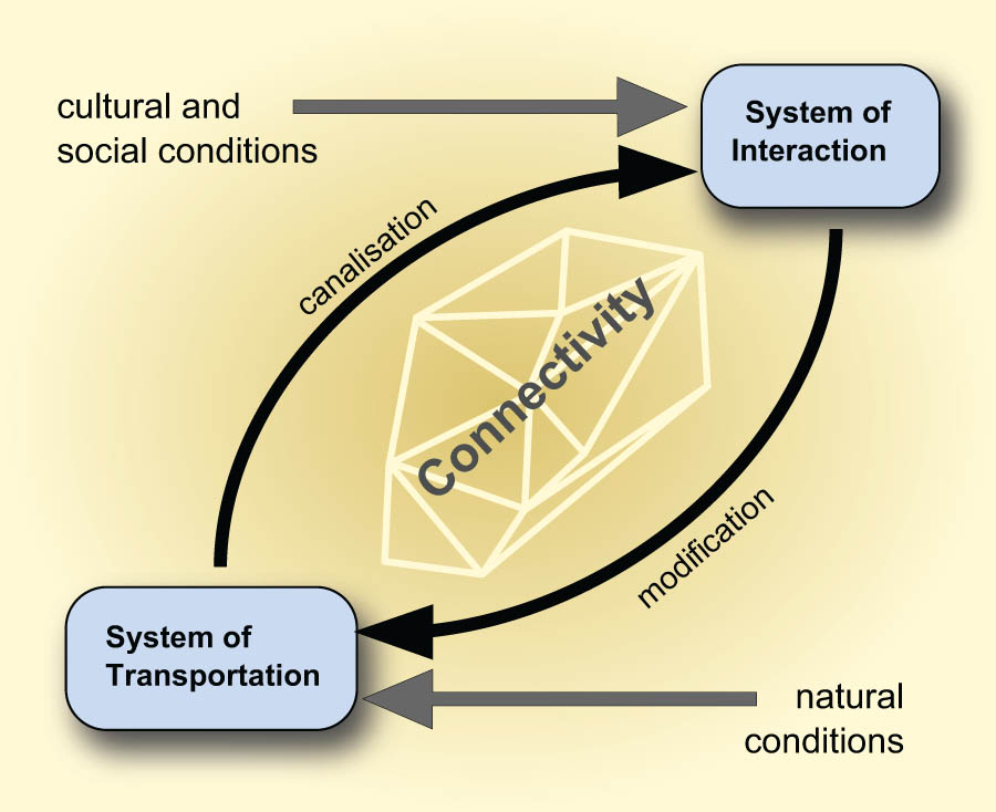
Transport research is a multidisciplinary field that extends beyond technical aspects. As such, it can provide significant insights into societies, economies, and cultures. In this study, we take a broader perspective that encompasses transport, interaction, and connectivity. These three terms are interconnected, with transport and interaction being interdependent sub-systems. Transport research encompasses means of transport, local, regional, and supra-regional networks, transport infrastructure, and the items transported. In turn, interaction research focusses on interaction networks, groups, and intensities. The concept of connectivity adds a layer of complexity, enabling a better understanding of the sub-systems and the system as a whole by considering the balance of opportunities and limitations. This article aims to demonstrate how the various approaches and concepts are related and to outline an integrated and systematic research approach.
Special Issue on Scales of Interaction in the Bronze and Iron Age Central Mediterranean, edited by Emily Holt & Davide Schirru
Lua Valenzuela-Suau, Sílvia Valenzuela-Lamas, Jaume García-Rosselló, Paloma Salvador, Jordi Nadal, Marta Díaz-Zorita Bonilla, Leopoldo D. Pena, Antonio Delgado, Manuel Calvo
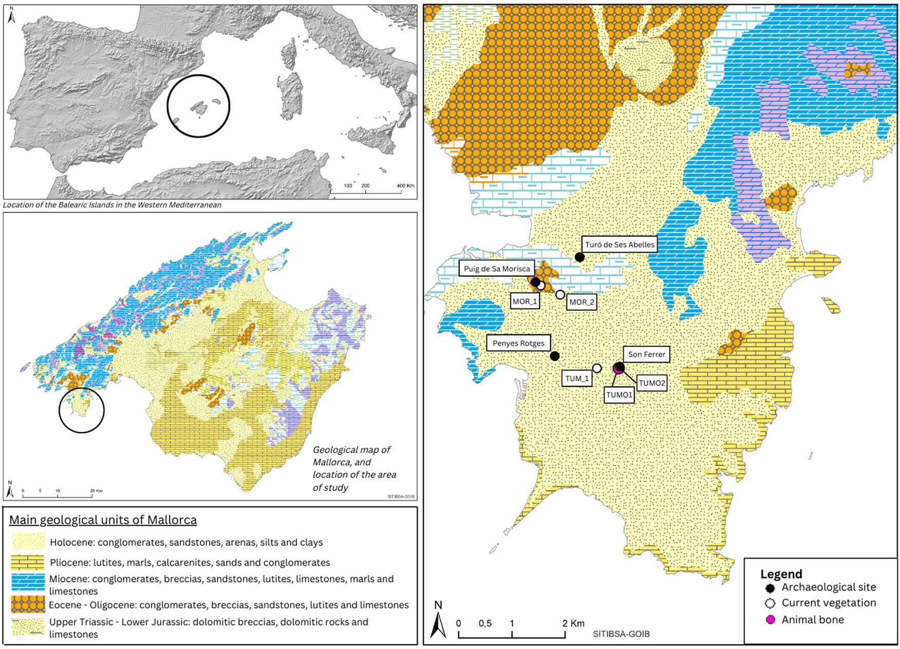
This is the first mobility 87 Sr/ 86 Sr analysis in human remains made on the Balearic Islands. Eight human individuals buried at the same Late Iron Age funerary chamber of Son Ferrer site (Calvià, Mallorca) have been sampled for strontium and oxygen isotopic analysis ( 87 Sr/ 86 Sr and δ 18 O). The study includes strontium and oxygen isotopic analysis of domestic mammals buried in the same Funerary Area (FA1) together with present-day vegetation and archaeological bone to assess the strontium isotopic ratios ( 87 Sr/ 86 Sr) around the site. All the results are compatible with the 87 Sr/ 86 Sr documented in Mallorca and, more specifically, with the surrounding bedrocks from the site. Humans, caprines, and dogs provided similar results and no significant differences are found between the species. The only exception is a caprine which shows seasonal movement through the period of enamel mineralisation. The isotopic information agrees with the previous studies, which proposed that Son Ferrer site was a symbolic place for the surrounding territory where people from the nearby villages were buried.
Using west-central Sardinia as a case study, this article explores how multi-scalar survey archaeology can be used to address questions of the intensity, nature, and scale of interaction in the Iron Age central Mediterranean. This large island played an important role in Mediterranean trade networks and was frequented and settled by Phoenicians, Carthaginians, and Romans, among others over the course of the first millennium BCE. These foreign groups interacted with local Nuragic people through trade, the exchange of ideas, and genetic admixing, which led to increasing connectivity over time. Large excavations at major colonial sites and genetic studies have reinforced the perception that interactions were felt most strongly in coastal regions, while inland communities remained more isolated. Our multi-scalar survey data, drawn from site-based survey at the inland nuraghe S’Urachi and regional survey in its surrounding territory (the Sinis Archaeological Project), supply information concerning how Iron Age interactions impacted inland rural communities. These data show how interaction transformed over time, as trade increased and agriculture intensified in response to external demands. Ultimately, we suggest that survey archaeology is an important tool for illuminating multi-scalar interaction in Sardinia and elsewhere.
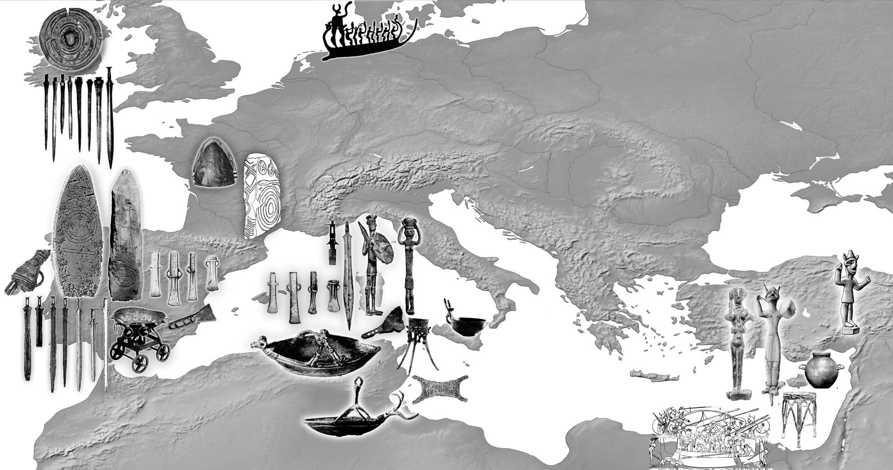
Sardinia was a hub of sea routes in the Final Bronze Age, c. 1200–850 BC, connecting the Aegean and the Levant in the East with the Iberian Atlantic façade in the West at its latitudinal extremes. Although situated some 1,200 nautical miles apart, bronze working techniques on the island, specific decorations, and implement typologies were clearly related to those in western Iberia, which was a pivotal node connecting the Atlantic and Mediterranean worlds. Without doubt, individuals have travelled between and beyond both regions, and transported objects alongside technological as well as theoretical information. Although serious challenges accompanied the multi-directional intensification of interactions, the local communities had innovative responses to them, managing to integrate new people and knowledge. The general aim of this contribution is to provide a theoretical framework with which to analyse the motivations and social mechanisms for cooperation and communication that facilitated technology transfer in an environment of dispersed, socially heterogeneous communities. The exchanges and interactions within this decentralised network must have been self-organised by individuals and communities, and encompassed all forms of entanglement. Consequently, practises of self-governance, hospitality, conflict management, and inter-group communication as well as shared symbols are of central interest.
Special Issue on Bricks Under the Scope: Microscopic and Macroscopic Approaches to the Study of Earthen Architecture, edited by Marta Lorenzon, Moritz Kinzel, & Benjamín Cutillas-Victoria
Throughout prehistory, earthen architecture has played a pivotal role in establishing a sustainable and easily maintainable built environment, showcasing humanity's capacity to design and construct intricate structures using eco-friendly and cost-effective materials. This special issue underscores the enduring significance of earthen architecture in our historical and contemporary understanding of sustainable building practices.
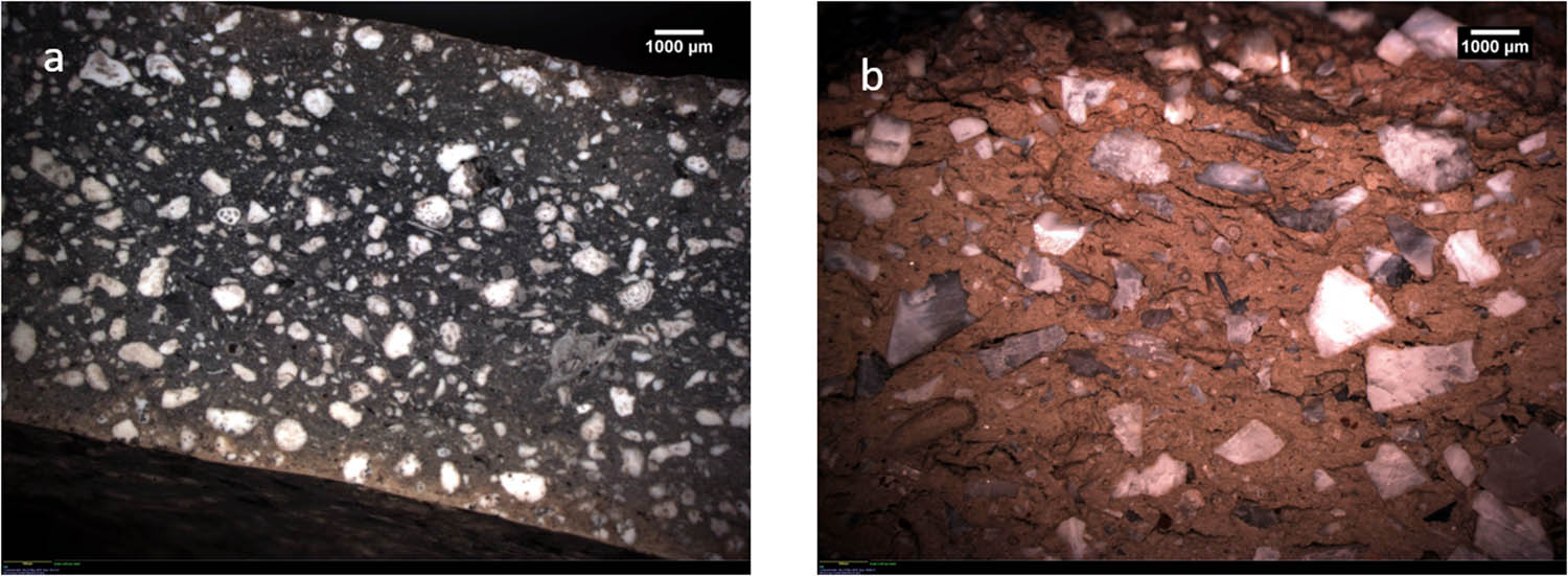
The use of mudbricks in Early Iron Age ramparts is an uneven feature of defensive architecture on the Iberian Peninsula. The use of mudbricks as a building material has been linked to the arrival of Levantine building traditions with the Phoenicians, and its appearance among local societies varies between the eighth and sixth centuries BC according to the public or domestic nature of the structures. In this article, we present the geoarchaeological analyses of the mudbricks used in constructing one of the defensive towers or bastions at Villares de la Encarnación (Caravaca de la Cruz, Spain). This site, endowed with two complex fortification lines and towers, is one of the main settlements for understanding the development of the Early Iron Age among the inland and mountain communities of the region. The analytical program includes wavelength dispersive X-ray fluorescence, CHN elemental analysis, and thin-section petrography and provides new data about soil procurement and manufacturing choices. These results highlight the technical and social complexity behind mudbrick constructions and the adoption of new earthen practices among Early Iron Age communities in order to build more imposing and elevated towers that might convey an image of the power and strength of these inland settlements.
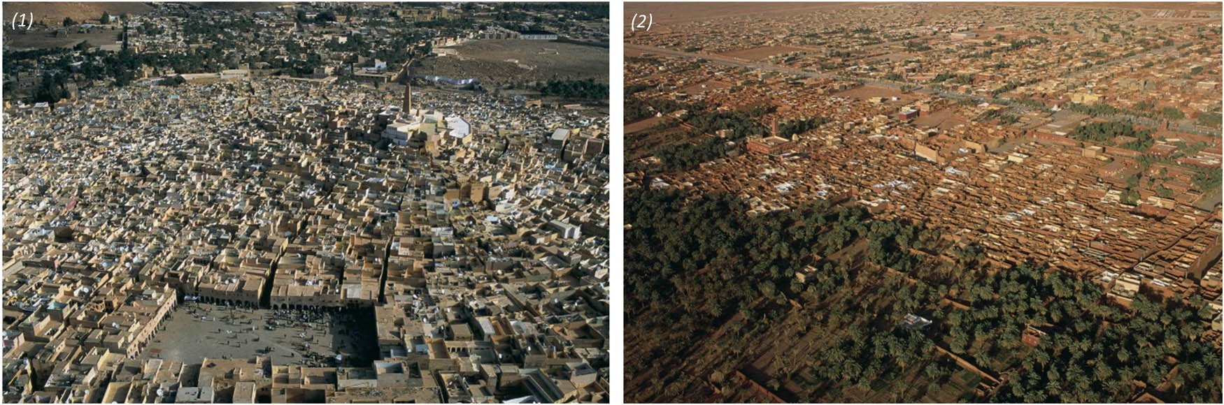
Earthen architecture constitutes a significant component of cultural heritage worldwide. However, this heritage is under threat due to a multitude of factors, including social, environmental, and economic changes. In South Algeria, earthen architecture is intimately linked to the identity of historic urban landscapes, particularly in Timimoun, the chief town of the gourara region. However, the shift towards industrial construction techniques and materials, encouraged by the state, has led to the abandonment of earthen houses and a neglect of traditional building culture. This poses questions about the evolving relationship between the inhabitants and their existing built environment in the context of changing social and economic conditions. To address this issue, we conducted an ethnographic study aimed to understand the significance and value of earthen architecture among local communities. Drawing on existing literature on the positive and negative views linked to earthen architecture, we employed a questionnaire to identify stakeholders’ preferences, choices, and attitudes towards this form of architecture. Through analysing the responses to the questionnaire, we have gained insight into the current state of earthen architecture and its significance. Our research findings provide valuable contributions to better comprehend the challenges faced by the preservation of earthen architecture and the cultural heritage it represents.
Using case studies from Aşıklı Höyük, Çatalhöyük, Boncuklu Tarla, Göbekli Tepe (all Turkey), and Monjukli Depe (southern Turkmenistan), this study presents a framework for in-depth research on prehistoric earthen architecture in southwestern and central Asia. It demonstrates the challenges and potential for innovative and comparative studies based on interdisciplinary approaches and the use of architectural, microstratigraphic, and microarchaeological analyses. Furthermore, it sheds new light on issues related to various aspects of building continuity which is commonly recognised as a very important phenomenon in the Neolithic but could have different facets. The study attempts to discuss the reasons behind the local decisions to use and recycle specified building materials. In addition, it evaluates – in relation to particular sites – the usefulness of specific analyses for reconstruction of daily, seasonal, or annual practices. Advanced analyses of floors and fire installations, for instance, can contribute not only to the identification of indoor and outdoor surfaces but also to a better understanding of activity areas and the intensity of use within particular spaces. Variations and different combinations of mudbrick, mortar, and plaster recipes allow for insights into how earth and sediment material were used to mark collective and individual identity through the performance of a building. Recognising reused materials and features allows us to trace further the nature of prehistoric societies and local architectural dialects.
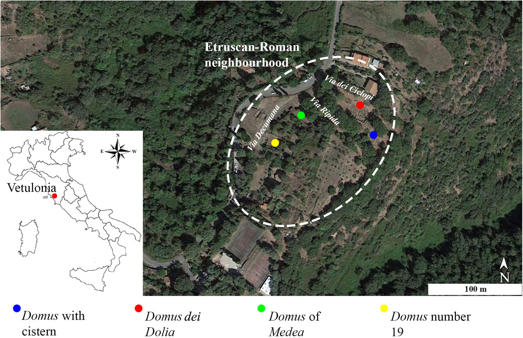
In this article, the archaeological and archaeometrical study of several roof tiles and bricks retrieved at the Etruscan Domus dei Dolia is presented. The Domus is located in Etrusco-Roman neighbourhood (Hellenistic – Late Republican periods, third–first centuries BC) of the ancient city of Vetulonia (central Italy), in the area of Poggiarello Renzetti . The main goals were to establish the characteristics of the raw material/s used in their production, the possible provenance, the technology applied, and to get insight regarding the production organization and the local economy. The archaeological materials were analysed by optical microscopy (OM), X-ray diffraction (XRD), and X-ray fluorescence (XRF). Principal component analysis was also applied to evaluate/interpret chemical data. Results evidenced that roof tiles and bricks were produced using a different technology and raw materials. Roof tiles were possibly manufactured within 12 km from the archaeological site and imported into the town, exploiting two different raw materials. Conversely, bricks were likely produced very close to the archaeological site. So, it is supposed that raw materials were selected considering factors such as distance, abundance, and accessibility to natural resources and security.
Research into prehistoric buildings in northwest Europe has identified the ubiquitous use of turf. The study first introduces direct and proxy evidence for the material’s detection in the field, then analyses individual case studies to demonstrate how this locally available and renewable material shaped buildings and building practices. Turf, grown and sourced on or near a site, ties buildings to their landscape, while creating flexible shells that can shift as needed, metamorphosing built space and volume accordingly. Turf’s capacity to then compost and regrow embeds its buildings into a prehistoric circular economy that interweaves dwellings, people, animals, plants, soils, and nutrients into a holistic understanding of a “curated” rather than a “built” environment – an architecture borrowed from the soil to which it can return. The characteristics of turf blocks as a malleable and arguably metamorphosing building material call for a rethink of turf architecture, not resulting in static products but in ongoing circular processes. This new concept operates within an extended lifecycle of houses, not as in traditional approaches from birth (built) to death (abandoned), but within a cyclical, cradle-to-cradle approach. An experimental training project now translates this prehistoric cyclical model into modern sustainable turf building practice to demonstrate its potential for positive climate action today.
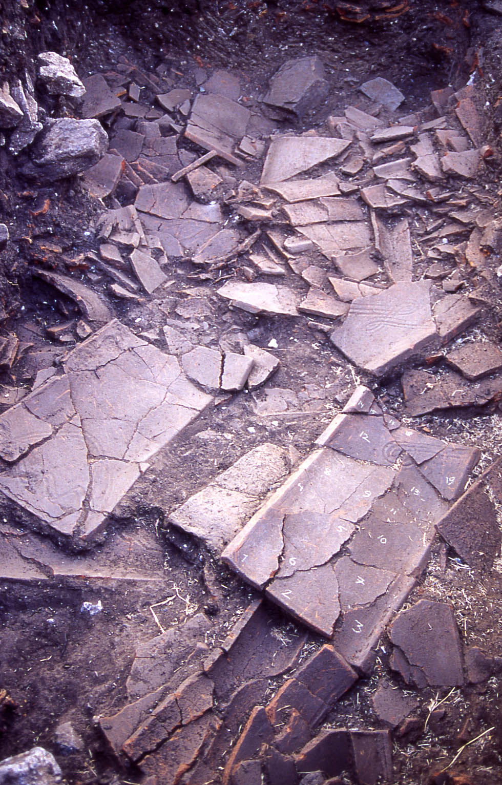
Undecorated ceramic roof tiles and their fragments are one of the most enduring and numerous remains of the earthen architecture of the Roman period to survive to us from many parts of the Roman world, especially from the Mediterranean region. Despite this, we have huge gaps in our knowledge regarding this material due to the sparsity in specialist studies and published excavation or survey records. The most detrimental gap is a lack of sufficiently fine-grained tile typology to easily situate and compare any tile material found. This work will outline the methodology used in the author’s recent research concerning Roman-period ceramic roof tiles in the Eastern Mediterranean and discuss the different ways we can approach undecorated roof tiles as material to gain valuable data. The work will also touch on the current limitation we have for further research in using this material as a dataset based on the status of research (limited and biased), the methodologies that would be most valid for research (e.g. is typology still a valid tool?), and the means we have in increasing the value of this material as a source for knowledge (better documentation). Such research allows us to gain meaningful and interesting new information on style, production, and transfer of knowledge and technology, which ultimately will help us to better understand how past societies functioned and interacted.
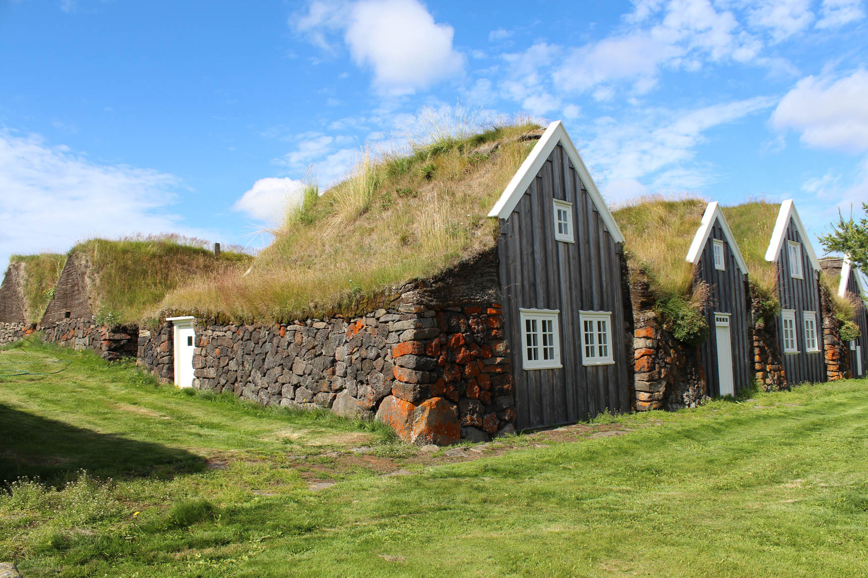
For a millennium, turf was the primary building material in Iceland. It was used for dwellings, outhouses, boundary walls, raised roads, and other man-made structures. Turf is known as an earthen building material in many countries, especially in northern latitudes, but the knowledge of how to build using it has mostly disappeared. As turf was used well into the twentieth century in Iceland, the skilled craft of locating, harvesting, and building with this material has been retained. This is also facilitated by still standing historical buildings and the need for continual maintenance. Archaeologists also benefit from learning about turf as they frequently interpret the remains of turf walls in the archaeological record. This means that Iceland is in a unique position to disseminate knowledge on this important intangible heritage. However, because of a lack of adequate funding and strategies for maintaining the craft, these skills are in danger of disappearing in Iceland as well. In this article, we discuss the state of knowledge on turf, what turf is, the preservation of the intangible building heritage, the revival of interest in turf, and how the various strands of evidence serve as background for the interpretation of turf as heritage and as an archaeological material.
Special Issue on Past Sounds: New Perspectives in the Field of Archaeoacoustics, edited by Margarita Díaz-Andreu & Neemias Santos da Rosa
Psychoacoustics offers a promising, subject-centred approach in unlocking the sonic experience of past built spaces. Its tools and metrics offer tempting responses to an essential challenge of sensory archaeology practice: the rendition of individual experience as data. How can one person’s experiences be compared with another’s towards generalized observations? Moreover, what can be said about past experience as a result? These questions are central to the ongoing acoustic consideration of the ancient sanctuary of Zeus on Mount Lykaion. Here the landscape that binds the sanctuary ruins offers noteworthy moments of sonic connectivity and isolation. Building on existing scholarship based on researcher perception, a sensory approach was developed to explore the site’s sonic relationships and ultimately determine what roles they could have played in original site usage, information beyond what the architecture and written record offers. Extensive site research uses first-hand sonic observation to frame a machine-based psychoacoustic analysis of binaural field recordings. Findings map out a sacred terrain of shared and singular experience orchestrated by sonic connectivity made available for further interpretation. They also underscore the necessity of caution in interpreting psychoacoustic findings themselves as an empathetic understanding of past people.
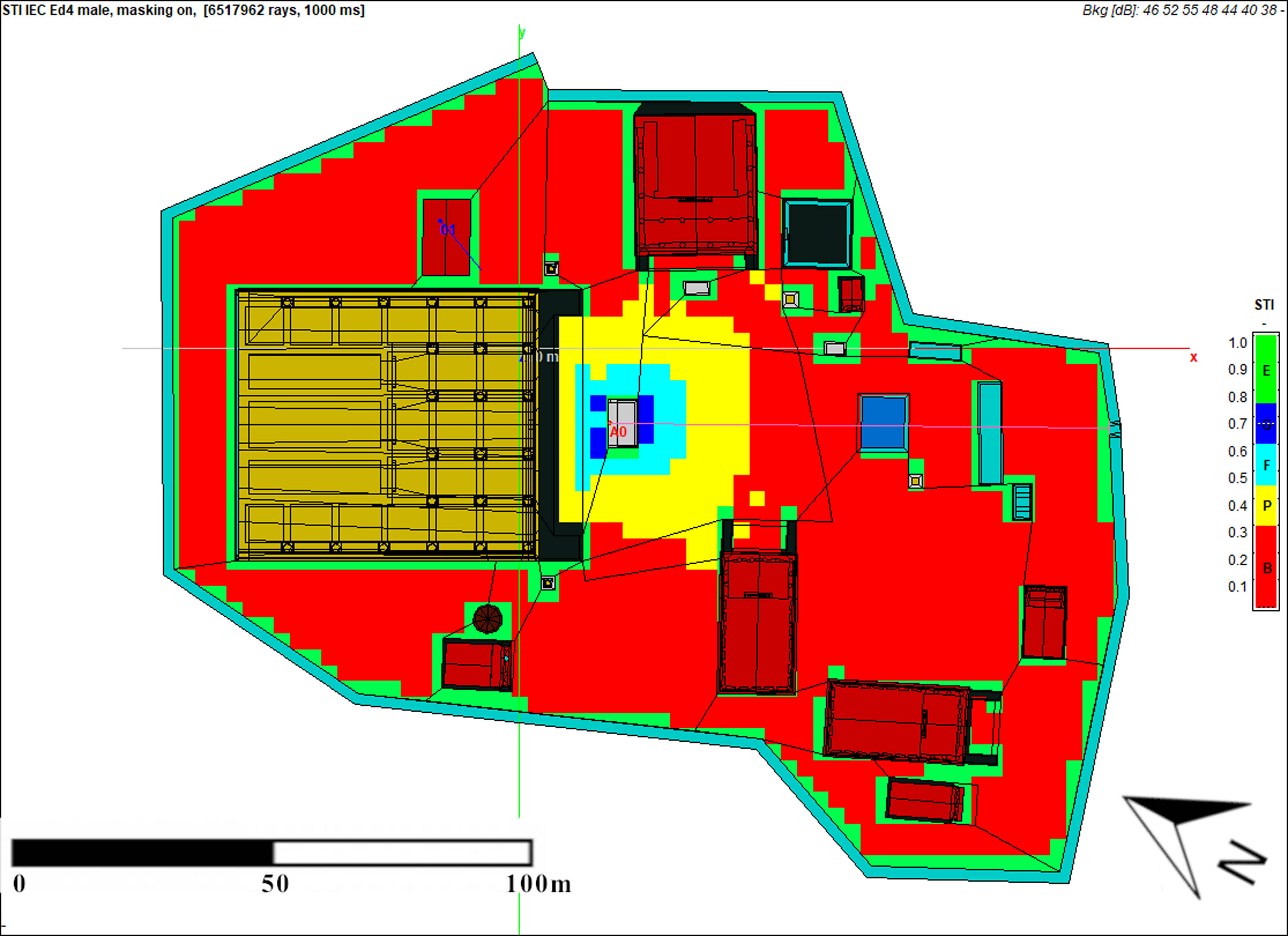
Rhetoric was one of the cornerstones of Roman education and public speaking, the essence of being a Roman politician. The speakers attempted to captivate the audience with their style and convince them of their arguments. Studying the audience is therefore just as important as investigating the speakers and their speeches. The aim of this article is to estimate the number of people who could intelligibly hear a speaker delivering a speech from two speaking platforms located in the city of Rome: the podium of the Temple of Bellona in the Campus Martius (in the Late Republican and Late Augustan periods) and the Capitoline Temple. To do this, we built virtual reconstructions of both venues according to the current state of knowledge about them, taking into account the geometry of the space as well as the materials from which they were built. On the models thus prepared, we carried out acoustic simulations for three different levels of background noise (36, 49, and 55 dBA), resulting in Speech Transmission Index maps. The results became the basis upon which we estimated the size of the maximum potential crowds that could hear speech intelligibly, using two methods based on the behaviour of contemporary crowds. We further compared our results with those of previous studies that concern other speaking platforms in Rome.
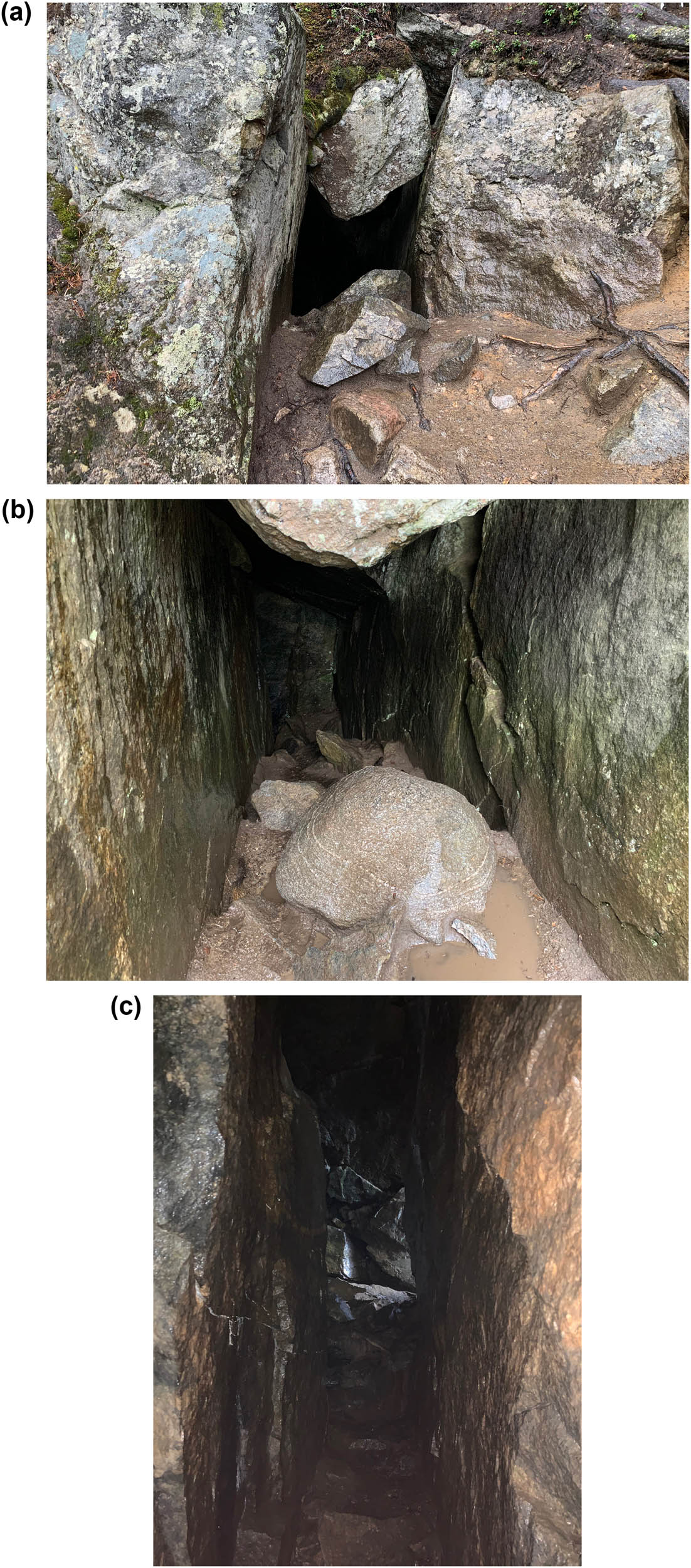
Pirunkirkko (“Devil’s Church”) is one of the famous caves in Finland. Tradition says that this crevice leading into the mountain was a meeting place for sages, who typically used sound to contact the spirit world. Today, the place is visited by practitioners of shamanism, who organise drumming sessions at the back of the cave. This article examines Pirunkirkko and the related traditions from the perspective of acoustics, hypothesising that the acoustic characteristics of the crevice might have played a role in the ritualisation of the place and the power of its rituals. Methods employed include impulse response recording, spectrum analysis, archival research, and interview of a shamanic practitioner. The results indicate that the back of the cave houses a distinct resonance phenomenon. A standing wave between the parallel walls generates a ringing tone at 219–232 Hz that stays audible after sharp impulses or vocalisations at the same frequency. The local folklore or the interviewed practitioner does not mention this phenomenon at all. Instead, they speak about the “spirit of the cave,” “special energy,” or “new horizons” opened up by drumming. This leads to reflection on cultural frameworks of thought that guide sensory perceptions leading to differing experiences and interpretations.
In this article, the potential of archaeoacoustics for understanding past communities is discussed by looking at a range of acoustic parameters. Our case study is the Urkosh rock art area in the Ongudai district, Republic of Altai (Russia). The rock art of this area dates possibly from the Upper Palaeolithic and definitely from the Early Bronze Age (second half of the third millennium BCE). There are important periods in the Early Iron Age (first half of the first millennium BCE) and the medieval era, after which there are later additions up to the present day. Major and minor sites were tested, as well as some with no art. The results obtained from the tests conducted using the impulse response method indicate high values for sound clarity not only in the rock art sites but also in at least one nearby panel without rock art. Although these results cannot explain why rock art was produced precisely in specific locations, they objectively describe the acoustic conditions under which particular intangible cultural practices were probably organised in them. In particular we focus on storytelling and music, cultural practices for which there is a wealth of information in the ethnographic sources written about the area.
The aim of this work is to analyse recent studies which have raised new hypotheses concerning aural architecture as an emerging trend in humanities research, with a particular focus on the intersection of sacred space, rituals, and sound in the past. These studies have highlighted how sacred buildings not only defined a sacred place as a physical and symbolic expression of a specific form of worship but also established the setting for performative and multisensorial ceremonies in which music, dance, and other sonic events played an important role. In this contribution, we investigate studies on aural architecture to explore if the location of sacred spaces indicates whether ancient people reacted to ritual and musical developments by modifying sanctuaries or by designing and constructing new buildings and spaces for performances. In addition, this article explores studies on aural architecture to obtain an overview of how specific sonic features could have influenced the soundscape of sacred spaces, which consisted not only of songs, music, prayers, recitations and religious sonic and vocal utterances but also of natural elements, such as animals, water, and wind. This overview also takes into consideration how digital technologies and virtual acoustics can help shape our understanding of the architecture-sound nexus.
Music and sound cannot be experienced through writing and numbers. Writing freezes time onto paper; as a time-based medium, sound cannot be heard without temporal motion, and acoustic metrics are silent data. For a complete experience of sound, it needs to engage our bodies. Digital multimedia technologies offer powerful approaches to understanding the acoustics of the past, and this work will explore a number of those affordances. In particular, this work explores the use of apps that illustrate archaeoacoustic effects, set digitally within visual and acoustic archaeological cultures. The ways of immersing audiences through projection, acoustic simulation, field and studio recordings, and musical performance will be discussed. The use of virtual reality (VR) headsets is explored to create a sense of deep-flow and presence amongst audiences, total immersion in an experiential phenomenological understanding of interacting audio and visual fields, as well as setting such results within an appropriate context. This study will examine how acoustics results at caves in Northern Spain, in various phases of Stonehenge, and at Paphos Theatre (all World Heritage Sites) can be explored using VR and multimedia technologies, evaluating the comparative advantages of the use of different technologies. It proposes that such integration of visual and sonic modelling using interactive digital technologies is effective as a non-representational theory approach to compliment empirical studies, allowing understanding that goes beyond numerical analysis and binary dialectics to engage directly with the material of archaeological sites in an embodied manner, and address the real-world complexities of acoustic ecologies and their contexts.
Special Issue on Reconsidering the Chaîne Opératoire: Towards a Multifaceted Approach to the Archaeology of Techniques, edited by Marie-Elise Porqueddu, Claudia Sciuto & Anaïs Lamesa
This article is an introductory contribution to our Special Issue Reconsidering the Chaîne Opératoire: Towards a Multifaceted Approach to the Archaeology of Techniques . The chaîne opératoire is a central and fundamental concept for archaeological studies that has been fully appropriated and repurposed by several generations of researchers. In this paper, we would like to present some of the points discussed and illustrated by the various articles in this special issue. The aim is to highlight theoretical and practical considerations in various fields, with a diachronic focus. From the biographical approach to the study of artefacts to the challenges of interdisciplinarity through cognitive and sensory approaches, the theoretical discussion is rich and innovative, acknowledging that the chaîne opératoire can be used as a tool for deciphering the complex network of artefacts, environments, and societies of the past and present.
The study of plaster vessels, white ware, from the Late Neolithic Southwest Asia (7000–5000 cal BC) is an untapped source that can provide us with valuable insights into the earliest development of pyrotechnology and Neolithic society. This plaster material is not well known and has not been involved in many studies. Using a symmetrical approach for the case study of plaster ware at Tell Sabi Abyad in Upper Mesopotamia, this article argues that it is crucial to acknowledge materiality in the study of these vessels. The ware resembles pottery in shape, typology, and basic function but is far from it material-wise and in its chaîne opératoire. The material plaster is also often misunderstood and associated primarily with architecture. Therefore, plaster ware stands at the crossroads between being observed as a copy of ceramics and being recognized as portable architecture. This article calls for an interdisciplinary approach, balancing the exact sciences of archaeometry and the theory of materiality. It will also address problems concerning terminology; it proposes replacing the term white ware with “plaster ware” as the most appropriate title for this ware because it can be better understood by a wider audience outside the discipline.
This article discusses the chaîne opératoire concept in prehistoric archaeology, traditionally employed for the study of lithic industries and ceramic production, and focuses on personal ornament manufacture. This category of non-functional objects has been analysed with the operational sequence approach in the framework of a research project aimed at the techno-functional study of prehistoric marble artefacts. Throughout an experimental approach, the study presents the actions and choices made by the artisans to produce marble beads and tries to understand the role and social-cultural meaning that these items had for the Copper Age communities in Tuscany. Finally, our study proved that the beginning of the use of the Apuan marble can be traced back to the sixth millennium BC, and it was connected with the production of personal ornaments, reaching its peak during the Copper Age.
Several marble sarcophagi, including both plain or fluted coffins and chests decorated with garlands, friezes, and elaborate compositions framed by columns and covered with roof-shaped or kline lids, are attested in the Roman burial grounds at Hierapolis in Phrygia (Turkey). Because of their repetitive, standardized pattern, fluted sarcophagi have been dismissed by scholars as the formulaic, more affordable output of local workshops. Contrary to the apparent simplicity, however, each item is highly individual with respect to the morphology of its mouldings and flutes, surface treatment, and decorative details. The majority of the pieces from the North Necropolis seem to have been carved in response to individual requirements. While rationalized modes of production likely dominated the economic landscape of the Roman sarcophagus industry, customers could exercise a significant degree of control over the pieces carved by local quarry-based workshops. Exploration of these processes, operational flows, and histories may yield new perspectives on the social and economic relationships that underpinned the production and trade of Roman sarcophagi.
Pottery-making practices have been approached by the use and application of the concept of chaîne opératoire in different parts of the world. This concept has allowed researchers to re-evaluate the social dimensions of technological studies as well as to explore aspects related to technical and social identity of ancient and modern artisans. In this article, we examine the use of grog (crushed sherds) to temper specific ceramic vessels (infant funerary urns) as material practice often used by ancient potters during Late (c. 950–1450 AD) and Inca (c. 1450–1532 AD) Periods in the Northwestern Argentine (NWA) region. The research shows that this practice can be understood as a ritual material practice with a long-standing tradition in the NWA region. Additionally, several alternative interpretations of this practice are explored in the light of different – animistic – understandings of how the Andean world works, and how people interact each other, with material things, and with landscape.
The Bonneuil quarry basin is located in the North-East of Paris; it played a role in the well-known stone trade for Paris and its surroundings in the nineteenth and the beginning of the twentieth centuries. Stonecutters of this area mainly used the extraction with the lance, a long iron spin bear by a scaffolding. This tool helped the quarrymen speed up their work allowing them to be competitive in trading. At the end of the 1930s, Martial Lefèvre, a wealthy owner of quarries in the Bonneuil’s basin, created a machine, roadheaders with rotating drill bits, following the movement of his quarrymen using the lance. The story of this machine was also involved in the Second World War and the occupation of France. Merging modern archaeology, history, and archaeology of technique, the aim of this paper is to explore the transition between hand tools and mechanical tools through the chaîne opératoire filter, a subject that is currently little studied. It also crossed the path of the delicate story of a small industry during one of the most events in France, the Second World War. Using it as an example, this article questions the status of these quarries during and after this main event.
The present study focuses on an Early Copper Age (4500–4000/3900 cal BC) atypical ceramic bowl from Tiszagyenda-Vágott-halom (Eastern Hungary). At first glance, the bowl was strikingly different from the other well-executed, often richly decorated bowls known from the site. Although such vessels can be found sporadically in other Early Copper Age sites, they have never been studied to see exactly how they differ from typical pottery. The aim of the present study is to understand the ideas, intentions, decisions, knowledge, and skills of the potter who made this vessel by reconstructing the chaîne opératoire of the making of the bowl. Technological and stylistic analyses suggest that the atypical pot was probably made by a beginner potter. The stylistic elements (form and decoration) are common in the pottery repertoire of the site and are not considered exceptional, apart from the quality of the execution. The deviation from the usual pottery-making techniques, however, suggests that the potter had probably not acquired all the pottery-making traditions of the community.
The article aims to show how a transdisciplinary approach can contribute to a better understanding of the composite biography of a precious object. The study focuses on the Cintola del Duomo (Museum of the Opera del Duomo, Pisa), one of the most famous objects in the history of goldsmithing, both for its exceptional manufacturing quality and for its devotional value. For a long time, the Cintola was considered a fragment of a long garland – decorated with precious stones, enamel, and silver plates – that was displayed on the façade of the Cathedral on certain days of the liturgical calendar. Detailed historical studies suggested that the garland was lost in the early 1300s, while the object now in the museum is more likely to be a reconstruction, decorated with ancient and modern gems. In situ diagnostic campaigns were carried out on the garland using portable Raman spectroscopy (i-Raman, B&W Tek) and portable X-Ray fluorescnece (XRF) (Elio, Bruker) to reveal the identity of the gems and enamels preliminarily studied by gemmological analysis. The combination of analytical techniques made it possible to better outline the complex history of the artefacts. The analysis provided information on the identity of the gems, proposing an interesting question about their possible relationship with the crown of Henry VII of Luxembourg (in the same museum). The study includes aspects related to the materiality of the objects, revealing the socio-cultural context in which the object was produced and supporting its recontextualisation in the museum as a symbolic representation of the past.
In recent years, studies focused on Chaîne Opératoire reconstruction of pottery vessels have shown important developments and provided new data related to vessel production and the complexities acquired by prehistoric societies. This research focuses on the pottery vessels discovered at the Mines Prehistóriques de Gavà (Barcelona, Spain), which constitute the earliest evidence of a mining center for variscite during the 4th millennium BC. The main objective of this study is to determine the technological procedures employed in the production of these potteries by identifying the Chaînes Opératoires and establishing their relationship to the site’s context, which is linked to extensive exchanges within the European network. Through a meticulous analysis and comparison of the morpho-typological and technological characteristics of the vessels, we aim to identify different production methods. The findings of this study, along with their reconstruction in techno-stylistic trees, contribute to a deeper understanding and explanation of the variability and technological complexity found in these pottery vessels. This work exposes a novel approach to studying the pottery vessels in Iberian Peninsula by involving the application of archaeometric techniques such as direct macroscopic and microscopic observation traces (using naked eyes; microscopic Dino – Lite), as well as chemical analyses such as petrographically and X-ray diffraction enabling the identification of key mineral components within the clay.
Downloaded on 17.10.2025 from https://www.degruyterbrill.com/journal/key/opar/9/1/html?lang=en&srsltid=AfmBOoqxms8gPcUorJwsyCfEQ1VZI6uqlnvxWQ8AUHvbaXD1kOhirBFo