Landscapes of Movement Along the (Pre)Historical Libyan Sea: Keys for a Socio-Ecological History
-
David Laguna-Palma
 and
Pablo Barruezo-Vaquero
and
Pablo Barruezo-Vaquero

Abstract
This study examines the influence of Human Ecodynamics and Historical Ecology to understand the complexities of historical mobility. Based on Landscape Archaeology, this study considers some of these theoretical principles for studying and reconstructing the movements of past human populations. This discussion is grounded on the example of a research project focused on modelling movement and interaction patterns between the Aegean area (Crete) and northeastern African region (Marmarica) from the Late Bronze to Roman times. The project works with multivariate data representative of the routes and non-human factors that may interplay in biocultural processes. Three key aspects structure this article: (1) the emergence of Human Ecodynamics and Historical Ecology in archaeology, (2) their impact on the theoretical evolution of Landscape Archaeology, and (3) the methodological implementation of these principles through a case study. We specifically discuss the strengths of Human Ecodynamics and Historical Ecology to enhance the conceptualisation of mobility by considering the heterarchical interrelationships between human and non-human agents. Our methodological implementations showcase this by using computational approaches to model human pathways influenced by and in constant relationship with their environment. This research thus highlights the importance of transdisciplinary approaches to studying historical mobility from an archaeological and complex systems perspective.
1 Introduction
Mobility has been a defining feature of human history, shaping societies and cultures across time and space. Understanding the drivers of these movements and the agents that shape them is essential to gaining insights into past human societies. This study explores an approach to understanding movement across landscapes from an archaeological perspective. Therefore, we seek to introduce a series of conceptual tools and methods to trace historical mobility. Influenced by Human Ecodynamics and Historical Ecology, our study highlights the socio-ecological context of past movements and, by extension, adopts a complex systems approach.
In the context of this study, the concept of migration enhances our approach to historical mobility by providing an alternative insight by which to interpret the past movements of people and their impact on societies. Understanding why people chose to move in the past provides insights into environmental dynamics, socioeconomic activities, political pressures, and cultural influences. We conceptualise migration (based on the Oxford English Dictionary, 2023) as the seasonal, temporal, or permanent movement of individuals, people, or communities, entangled with animals, plants, and so forth, from one place to another, in conjunction with material (objects) or immaterial (ideas) flows – implying exchange or the act by which objects and ideas are being passed. Such movements are normally triggered by external factors (e.g. conflict, climatic changes, trading, etc.) and leave footprints on landscapes (e.g. change in or extension of socio-ecological niches). Thus, our definition underscores the idea that movement occurs in the landscape and involves non-human agents. This is an operational definition that suitably conforms to our approach, which specifically focused on tracing and modelling the movement along the Libyan Sea (Crete and Marmarica) from the Late Bronze to Roman times (ca. 1400 BCE–300 CE) (Figure 1). In this, we adopt a complex systems perspective to unravel the interaction patterns of the communities that inhabited these regions that additionally accounts for the human–environment interactions associated with historical mobility.
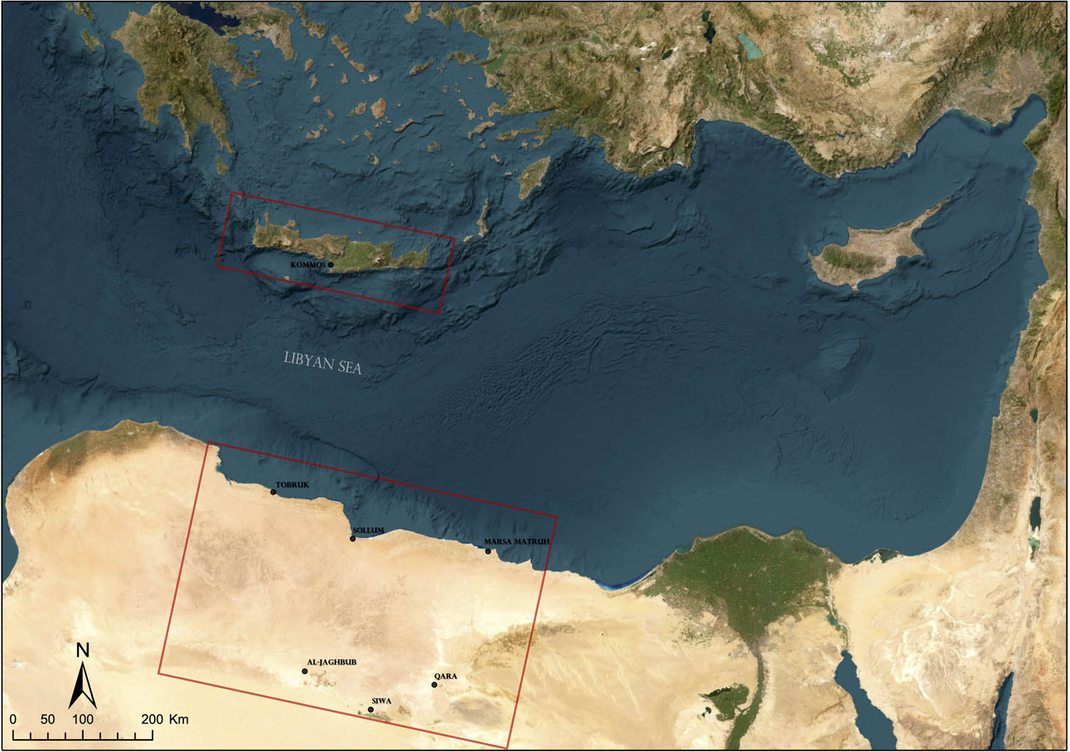
Map of the Eastern Mediterranean with general locations mentioned in the text (Basemap: © ESRI).
Our purpose is to develop a diachronic account of possible regional and supraregional flows of movement generated by different communities’ economic and social exchanges. This study explores these dynamics through a case study focused on Marmarica (northeastern Libya and northwestern Egypt). This region has often been marginalised within a narrative that predominantly relies on textual and iconographic sources from neighbouring groups (Cooper, 2022). Moreover, prior archaeological endeavours within Marmarica have tended to focus on specific locales – for instance, northern zones of Western Marmarica (Hulin, 2008; Hulin, Timby, Muftah, & Mutri, 2010; Hulin, Timby, & Mutri, 2009) and Eastern Marmarica (Rieger, 2017, 2019, 2023), among others. Notwithstanding these studies, there is no comprehensive study of the entire Marmarica region, nor research considering it in its own historical right. Such an absence is problematic, considering its relevant geographic position as a hub within the exchange circuits between Cyrenaica and the Nile Valley, as well as between the Eastern Mediterranean harbours and the hinterland oases. Therefore, shedding light on its historical mobility and interaction patterns contributes to a more comprehensive understanding of the interconnections that have shaped the northeastern African landscapes in the broader Mediterranean context.
The complexity of this research has led us to implement different approaches such as site mapping, GIS spatial analysis, and network research. The systematic exploration of historical cartography and aerial imagery enabled the mapping and recording of archaeological remains (Rayne et al., 2017; Wilson, 2021), serving as proxies to infer human mobility. Furthermore, we deployed accumulated cost surface analysis, specifically the focal mobility network (FMN) (Déderix, 2016; Llobera, Fábrega-Álvarez, & Parcero-Oubiña, 2011), to derive historical human pathways. Finally, archaeological network research (Brughmans, Mills, Munson, & Peeples, 2023; Brughmans & Peeples, 2023) enabled us to examine the intricate connections that have shaped human interactions across the Marmarican landscapes. Our research also considered various environmental factors and their interrelationships with humans. Principles derived from Human Ecodynamics and Historical Ecology (Fitzhugh, Butler, Bovy, & Etnier, 2018) helped to better conceptualise, model, and shed new light on the complexities of analysing these landscapes from an archaeological approach.
This article ultimately intends to connect the theoretical and methodological aspects of our research. Therefore, the first part of the article is a brief theoretical presentation of Human Ecodynamics and Historical Ecology and their impact on Landscape Archaeology. We subsequently present some insights into what these approaches bring forward for understanding the landscape from a complex systems perspective. The following sections expound on different aspects in which this theoretical basis directly influences our methodological approach to modelling past movements. The article concludes by discussing our approach to conceptualising past, but also present, mobility dynamics.
2 Theoretical Framework: The Role of Socio-Ecological Factors
2.1 Human Ecodynamics and Historical Ecology
Since J. McGlade coined the concept of Human Ecodynamics in 1995, it has steadily gained traction in archaeological research. It aims to study the historical and long-term interrelationships between humans and the environment through space and time, assessing the agency that both these entities have on each other (Harrison & Maher, 2014; McGlade, 1995). In other words, its aim is to analyse the socio-natural system(s). Similarly, the concept of Historical Ecology developed by Crumley and colleagues (1994a) has also been increasingly used in anthropological and archaeological research. Like Human Ecodynamics, Historical Ecology refers to the study of the coevolutional, dialectical, dynamics between human and non-human agents, where non-humans’ agency enacts its influence upon both themselves and humans, and vice versa (Crumley, 1994b). These mutual and entangled interrelationships facilitate the development of sociohistorical structures that work at different spatial, temporal, and systemic scales (Fitzhugh et al., 2018; Marquardt, 2019).
Both approaches might arguably be complementary, considering their aims – the synthetic and historical study of the interactions between human and non-human agents. Moreover, both assemble a number of features that can be implemented in a complementary fashion, specifically to understand landscapes as the spatial manifestation of such interactions (Barruezo-Vaquero & Laguna-Palma, 2022; Fitzhugh et al., 2018; Ray, 2019; Sinclair, Moen, & Crumley, 2018). In sum, they share a common understanding of non-linear dynamics/heterarchical agency to trace human–environment interrelationships from a long-term perspective (Crumley, 1994a,b, 2019; Fitzhugh et al., 2018; Harrison & Maher, 2014; McGlade, 1995). If at all, it could be argued that Historical Ecology studies human ecodynamics. But in any case, these scholarly approaches converge (Kirch, 2005). For this reason, and for the sake of simplicity, henceforward we will normally use “HE” to encompass both Human Ecodynamics and Historical Ecology.
2.2 Exploring the Core Tenets of HE: Entangled Relationships
One of the core concepts that sets HE is the recognition of entangled relationships between human and non-human agents. Such entanglements have significant implications for understanding landscapes as entangled places (Eriksson, Ekblom, Lane, Lennartsson, & Lindholm, 2018). The idea of entanglement also bears significance because it can merge other concepts brought by HE, including mutual agency, non-linearity, and heterarchy. By incorporating these concepts, HE’s research can provide a more comprehensive and nuanced understanding of the relationships between humans and their environments. This understanding is essential in studying historical mobility, as it recognises the interconnectedness of both factors and how they shape one another over time. Ultimately, HE’s approach to entangled relationships provides a rich framework for investigating complex and evolving interactions in changing socio-ecological contexts.
2.2.1 Mutual Agency
HE renders a dialectical interrelationship between the human and non-human agents of the Earth’s biophysical system to explain how socio-natural systems operate (Marquardt, 2019). As stated by McGlade (1995), “structures are maintained only by constant energy/matter and entropy exchange, in which the action of positive feedbacks of environmental and cultural processes drive the system to new evolutionary states, which in turn provide the conditions for renewal of higher entropy production.” In other words, HE emphasises the interconnectedness between the human and non-human agents of socio-natural systems and how they mutually shape and influence one another through constant exchange and feedback loops.
Hence, it follows that analysing socio-natural systems requires envisioning these systems as composites, wherein each component can potentially interact with every other component. This has both epistemological and ontological implications. Following Ingerson (1994, p. 45), we should understand the culture/nature dichotomy as “quantitative variations along a single spectrum rather than as an either/or dichotomy [which, as a consequence,] requires us to disassociate qualities and characteristics” traditionally labelled either as “social” or “natural.” We find the concept of mutual agency quite suitable in this context. Mutual agency implies that humans and non-humans are deeply entangled through their agency. Indeed, as Bauer (2018; also, Bauer & Ellis, 2018) argued, it is through the recognition of this bidirectionality that we can correctly understand the ontological intertwinement between humans and non-humans. Moreover, such mutuality through bidirectional connections allows the system to change and, therefore, evolve. Thus, the synergy between humans and non-humans drives co-evolutional dynamics, which leads to arguing that history might be conceptualised as the coevolution of multiple species (Fitzhugh et al., 2018).
Understanding the synergy generated by the mutual agency of human and non-human agents is the task of HE (Maher & Harrison, 2014, pp. 2–3). To do so, HE incorporates an approach based on Complex Adaptive Sciences (CAS). The approach of CAS is not so much placed on the agents per se, but rather on the holistic picture derived from the agents’ interactions, changes, and patterns at multiple scales (Sinclair et al., 2018). These interactions and their governing mechanisms are thus of utmost interest; two other concepts in HE can be quite useful to describe them: non-linearity and heterarchy.
2.2.2 Non-Linearity
HE applies a reasoning based on non-linear dynamics of causality (McGlade, 1995). Complex dynamical systems, such as socio-cultural or biocultural ones, have the capacity to generate unpredictable, emergent behaviour via non-linear, especially chaotic, feedback. A direct consequence is that the systemic dynamics of causality hinge on an (initially) indeterminate number of agents who vary in number and effect depending on the moment, place, and scale of analysis. As such, “ecosystem structure is viewed as a series of weakly coupled sets within a hierarchy of process rates involving biotic interaction […] and abiotic factors […]. The non-linear couplings in these processes are further complicated by human action” (McGlade, 1995, p. 121). To understand these complex dynamics, it is essential to decompose the global picture into smaller parts, following a hierarchical analytical approach – as McGlade uses it within the context of hierarchy theory –, and gear them into a concrete, broad narrative.
This approach to causal explanations is fundamental to interpreting human–environment entanglements. Non-linearity accounts for the interlaced dynamics of complex systems, offering a more nuanced and comprehensive understanding of the interactions that occur within socio-natural systems (Maher & Harrison, 2014, p. 2; McGlade, 1995; Winterhalder, 1994). It can be said that non-linearity is one of the foundational governing principles driving the mutual agency of human and non-human agents.
2.2.3 Heterarchy
If non-linearity governs human–environment interrelationships, heterarchy is a type of organisation that defines the character of such interrelations for HE. Heterarchy defines a complex system that allows elements to be ranked or unranked (relative to other elements) in several ways depending on systemic requirements, creating a dynamic structure in which power and influence are distributed among various agents (Crumley, 1994b, p. 12). This is in contrast to hierarchies, where elements are ranked in a fixed order. In a heterarchy, the relative importance and behaviour of agents, whether human or non-human, are not constant but fluctuate depending on spatial and temporal contexts, leading to a flexible and adaptive structure of human–environment interrelationships.
As previously mentioned, non-linear bidirectional interrelationships involve multiple agents operating within a complex system across diverse spatial and temporal scales. The power that agents – be they human or not – can effect upon others is not static but variable; at times, they might be stimulators/dominant or respondents/dominated (Crumley, 2019, p. 293). Consequently, the relative behaviour and importance of agents are not static; their actions, interactions, and results fluctuate in response to changing circumstances, leading to a context-sensitive and adaptable system.
2.2.4 Multiscalar: Long-Term, Large (Distributed) Scale
Historical ecologists have been vocal about the importance of using multiscalar archaeological data to gain a comprehensive multitemporal and multi-scalar understanding of human–environment interrelationships (Hambrecht et al., 2020; McGovern, Hambrecht, & Hicks, 2019; Ray, 2019). According to this approach, the landscape is the fundamental unit of analysis from which to develop a framework that includes distributed (local, regional, interregional, and supra-regional), longitudinal, and multitemporal (longue durée) sites. The coinage of the conceptual phrase “Distributed Observing Network of the Past” (DONOP) by some practitioners encompasses this perspective: “through the analysis of archaeological datasets, we have the potential to access long-term records of human interactions with natural systems at a wide variety of temporal and spatial scales and thus both reconstruct past environmental conditions and reveal the human dimensions of these processes” (Hambrecht et al., 2020).
Incorporating different spatial scales, from local to interregional, enhances the study of historical human–non-human interrelationships (Hambrecht et al., 2020). However, it is important to note that inclusion does not mean decontextualisation. Instead, a comparative and inclusive perspective that pays attention to each context is necessary to deploy coherent analyses. Multiscalar thus means to integrate different cartographies within the same narrative. The ultimate goal of such an approach is to provide “historical and diachronic knowledge of human–environmental relationships” and their impacts, which can inform present concerns (Ray, 2019).
2.3 Complex Systems Theory
The exploration of complex systems – or at least its conceptualisations – enhances the understanding of Human Ecodynamics and Historical Ecology, as these arguably analyse complex systems (for a comprehensive study on complex systems applied to archaeological research, see Daems, 2021). Complex systems are those characterised by complexity. Although sketchy to define, complexity can be described as the convergence of a plurality of properties: non-linear behaviour, self-organisation, emergence, adaptation, non-equilibrium, interdependencies among components of a system, processing of information, etc. (Daems, 2021, p. 35). Any complex system thus possesses these properties, albeit the degree of complexity may vary within the system (and scale of analysis). It is important to note that complex systems adapt through time due to the constant exchange of feedback and processing by the components of said systems. For this reason, complex systems can be considered complex adaptive systems (Daems, 2021). Complex systems theory describes and seeks to understand how these systems behave and evolve through time.
The epistemic basis of complex systems theory clearly benefits HE, which, in essence, studies complex adaptive systems. Indeed, the core analytical tenets of HE previously described match with the properties exhibited by any complex system: mutual agency describes the profound interdependencies among human and non-human agents, as well as the processing of information happening between them. Moreover, mutual agency develops in a heterarchical and non-linear way, which leads to emergent phenomena and changes in the system’s state. These processes occur at multiple levels within a biocultural system; hence, HE seeks to understand multi-scalar changes and their drivers. In this context, complex systems theory emerges as an appropriate analytical and conceptual tool for HE.
2.4 Epistemological Considerations: A Brief Comment on Research Methodologies
The study of complex systems, such as human–environment co-developments, has epistemological consequences and requires a framework capable of articulating human and non-human agents in a multi-scalar approach (Marquardt, 2019; Winterhalder, 1994). From a spatial point of view, this means not to privilege one scale over another but to account for the interlacement of different spatial scales, from the micro to the macro. The concept of DONOP reinforces this latter aspect.
Understanding heterarchy challenges traditional hierarchical frameworks. Strict hierarchical models are normally at odds with unravelling heterarchical processes because they assign fixed and rigid categories or values to explain how agents work within a given system. This is problematic for understanding complex, dynamic, and multidimensional chains of causation (Crumley, 1994b, p. 13). A heterarchical approach is essential to overcome these problems. In a framework based on HE, each agent’s importance will vary according to the spatial-temporal context and degree of freedom-to-act in that context (Marquardt, 2019). Any framework seeking to articulate HE or that considers human–environment interrelationships should thus develop mutable interlinks between the chosen scales of analysis.
Heterarchy is also applicable to the use of diverse disciplines, theories, and methods. Diversity can be an opportunity to deploy holistic research, instead of being seen as an insurmountable divergence (Crumley, 2019). Disciplinary barriers work against the analysis of complex phenomena. To resolve this issue, some researchers (Crumley, 1994a,b; Meyer & Crumley, 2011) have proposed to use as many theories and methods as possible to solve a specific problem, depending on the context and available sources of information. This heterarchical vision conceives disciplines, theories, and methods not as closed boxes but rather as intertwined sets of tools – a toolbox (Crumley, 2017). Thinking of disciplines, theories, and methods as a toolbox can open up the possibility of working within transdisciplinary frameworks (e.g. Acosta-Naranjo & Domínguez, 2014; Lethbridge & Hartman, 2016; note, however, that ‘transdisciplinary’ has also been used to refer to the inclusion of different social sectors to our research: Milek, 2018). Complex systems theory can also reinforce this perspective by signaling the need for a consilient approach capable of merging data, methods, and theories across disciplines (Daems, 2021, p. 10).
2.5 How These Theories Influence Our Understandings of Landscapes
The incorporation of many of the ideas brought by HE has enriched discussions about how to attain our original aim, i.e. understanding movement through the landscape. Movement, i.e. human interactions, does not occur in a vacuum or a blank setting but occurs in the landscape. Hence, this research is fundamentally based on Landscape Archaeology. Admittedly influenced by Crumley (2017), we argue that HE’s framework is better deployed through the study of landscapes. The project thus considers the definition of “landscape” fundamental to operationalise our research. Our way to represent and analyse interactions across landscapes is through an ontological approach influenced by HE. This section aims to connect HE’s principles seen above with conceptualisations purely based on Landscape Archaeology.
From a general and broad perspective, we conceive the landscape as a space that encompasses, as if it were a single unit, the physical environment and other non-human agents and human remains (settlements, sacred and productive places, mobility structures, etc.) (Ashmore & Knapp, 1999; David & Thomas, 2016, pp. 38–40; Martín Civantos, 2008, pp. 26–35; Moreland, 2010). All of these factors are arguably interconnected, entangled, as in a network. For this reason, we conceive the landscape as a network compounded of multiple and distinct elements present in the same reality (see Kowalczyk, 2020 for a similar proposal).
Accordingly, concepts used in Landscape Archaeology, such as environment or nature, should be understood from a broad and integrative perspective, although excluding humans for analytical reasons. In this guise, “nature” or “environment” encompasses the non-human biotic and abiotic factors (atmosphere, relief, water flows, soil pedogenesis, vegetation, etc.) (Malpica Cuello, 2009). In sum, what landscape archaeologists have normally denominated as environment or nature can also be called non-human agents, or factors, according to the influences of HE and posthuman thinking (Crellin & Harris, 2021).
Landscapes are anthropic artefacts, too (Martín Civantos, 2009). As Trigger (1967, p. 158) points out, every social relationship and process has an impact and reflection on the landscape. Moreover, humans socialise their landscapes, both communally and individually, through different experiential dynamics (Ashmore & Knapp, 1999; Egeler, 2019; Ingold, 1993; Johnson, 2012; Martín Civantos, 2008). Thus, human agency, with its social and symbolic dimensions, is also part of the landscape. Therefore, landscapes are both social and cultural (Giacomorra, 2006, p. 34). Ancillary to this premise is the temporality of landscapes, which, in a sense, resonates with Crumley’s concept of longitudinal research (McGovern et al., 2019). If landscapes are reflections of human action throughout history, then the social actions in a place over time add different modifications and additions to the landscape – they are historical palimpsests (Martín Civantos, 2011; Tello, 1999). From this perspective, landscapes are (partly) the epidermal manifestation of economic, cultural, and political changes; i.e. they are historical, cultural, and socio-economic (Criado-Boado, 2017; Martín Civantos, 2008, 2011) and should be analysed a la longue durée.
It can be argued, in sum, that landscapes are the product of historical and dialectical interrelationships between humans and non-humans. They are historical socio-ecosystems (Martín Civantos, 2018), and hence, the “spatial manifestation” of humans and non-humans through time (Ray, 2019). Applied to our study, this requires understanding key cultural aspects of movement while recognising the embeddedness of non-humans in such a process.
3 Materials and Methods
3.1 Case Study: The Marmarica Region (NE-Libya/NW-Egypt)
Considering the scope of this article, we have selected the region of Marmarica, present-day northeastern Libya and northwestern Egypt (Figure 1). The purpose is to illustrate the potential of our theoretical and methodological approaches for a better understanding of past movements and historical interactions. In this way, we can illustrate how these procedures can be applied in a specific context and demonstrate their results in practice.
3.1.1 Sources and Data Acquisition
Our study required sources and data, including legacy data, of different natures to cross-check and obtain further archaeo-historical and environmental information about this northeastern African region. Therefore, integrating published field data surveys, archaeological reports, maps, historical aerial photographs, and satellite imagery has proven valuable. These resources have been particularly useful in identifying scattered archaeological remains and traditional paths, which are typically considered proxies for inferring the human mobility of communities across landscapes. Moreover, environmental and geographical indicators can be reconstructed from these resources, thus allowing for a more holistic approach in line with our theoretical framework.
The identification of these archaeological remains in the specific case of Marmarica draws upon a variety of sources, most notably the aerial photographs taken by Squadron 113 of the Royal Air Force (RAF). The RAF flew over large stretches of the Eastern Marmarica coast using Hawker Hind Lighter Bomber biplanes from September 23 to November 1, 1938, to map through photographs this strategic region in the pre-war context of the Second World War (Ray & Nikolaus, 2022). These photographs provide a unique snapshot of the landscape and environment. Another crucial source of information is the cartography used, primarily based on a series of maps produced by the US Army Map Service that covers the entire study area and dates from the Second World War to the Cold War (Figure 2). Specifically, the P502 series (1954) of the US Army Map Service, 1:250,000 stands out. This latter series derived from the information provided by the Middle East Command maps produced in 1941–1942, which were based on the information collected in 1916 by the “Survey of Egypt” for the territories covering northeastern Africa (Vetter, Rieger, & Nicolay, 2014, p. 44).
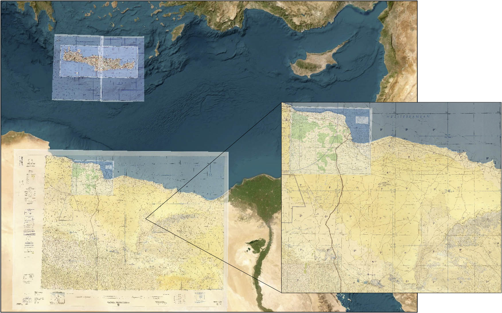
Georeferenced historical topographic maps of Crete (Greece) and Marmarica (northeastern Libya/northwestern Egypt) (Basemap: © ESRI).
The information gleaned from these sources is of great relevance for two main reasons. First, it provides insights into both human and non-human agents, encompassing topographic and hydrographic features, as well as the exact locations of ancient settlements, burial sites, productive areas, traditional routes, and so on. Second, the collected information predates the large-scale agricultural, urban, and industrial developments that took place in this region from the second half of the twentieth century. As such, these data provide a valuable record of landscapes that no longer exist or that have undergone significant changes over time.
Two comprehensive datasets were developed to collect and process the archaeo-historical and environmental information within a GIS framework (ArcGIS 10.5). This was done in order to systematically record the archaeological sites and traditional paths that were identified. The first dataset integrates the information associated with each archaeological site, considering the variables listed in Table 1. The second dataset contains information related to historical routes, considering the variables listed in Table 2.
Sites database’s record structure
| Variable | Type | Example |
|---|---|---|
| ID | String | PE_00004 |
| Zone | Numeric | 2 |
| Modern_Name | String | Zawiyet Umm el - Rakham |
| Old_Name | String | Unknown |
| Coord_x | Numeric | 27.025833 |
| Coord_y | Numeric | 31.4 |
| Accuracy | String | High |
| Validation | Numeric | 4 |
| Type | String | Settlement |
| Subtype | String | Fort |
| Eco_Zone | String | Coastal zone and northern tableland |
| Risk_Level | String | High |
| Cod_Risk | String | 5, 6, 7 |
| Remains | Dichotomous | Yes |
| Chronology | String | Late Bronze |
| Keywords | String | New Kingdom, Ramesside period, Cannanite amphora, Stirrup-jar, Temple |
| Description | String | Located on the Marmarica coast of Egypt, 20 km to the west of Marsa Matruh. During the Ramesside period, it was the location of a major fort which probably marked the western extent of Egyptian influence |
| Biblio_ref | String | (Snape, 2003, pp. 19–20; Nielsen, 2017); http://vici.org/vici/21476 |
Routes database’s record structure
| Variable | Type | Example |
|---|---|---|
| ID | String | PE_NET0004 |
| Zone | Numeric | 2 |
| Name | String | Masrab Istabi |
| Start_point | String | Marsa Matruh |
| End_point | String | Siwa |
| Length | Numeric | 308 |
| Type | String | Main route |
| Cod_type | Numeric | 3 |
| Knowledge | String | Demonstrable |
| Cod_know | Numeric | 3 |
| Aegean_chr | String | Iron Age |
| Egypt_chr | String | Third Intermediate period |
| Description | String | Digitization based on satellite imagery, cartographic, and survey data |
| Biblio_ref | String | US Defense Mapping Agency Aerospace Center. 1991. TPC H-4B, Egypt. [Tiff]. 1:500,000. (Vetter et al., 2014, p. 477; Grosskopf & Rieger, 2019, p. 54; Rieger, 2017, p. 54) |
The subsequent step involved mapping the terrain surface using remote aerial survey techniques. GIS was used to georeference a variety of historical sources, including topographic maps, historical aerial imagery (as detailed above), field survey data, and published archaeological reports. Control points located on the surface were systematically used to select easily identifiable topographic features, which allowed precise linkages in terms of geospatial position. The study area was then divided into 10 × 10 km2, within which a thorough remote aerial survey was conducted by crosschecking our sources and imagery. Thus, GIS was instrumental in allowing us to obtain precise information on the locations of archaeological sites and historical paths (Figures 3 and 4).
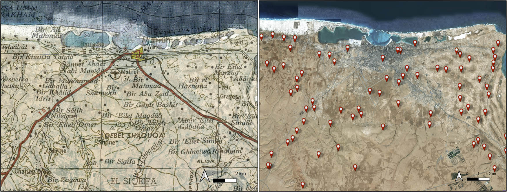
(Left) Topographic map from 1954, US Army Map Service (P502, Sheet NH 35-3 Matruh). (Right) Spatial distribution of digitised sites covering the Marsa Matruh area (Basemap: © ESRI).
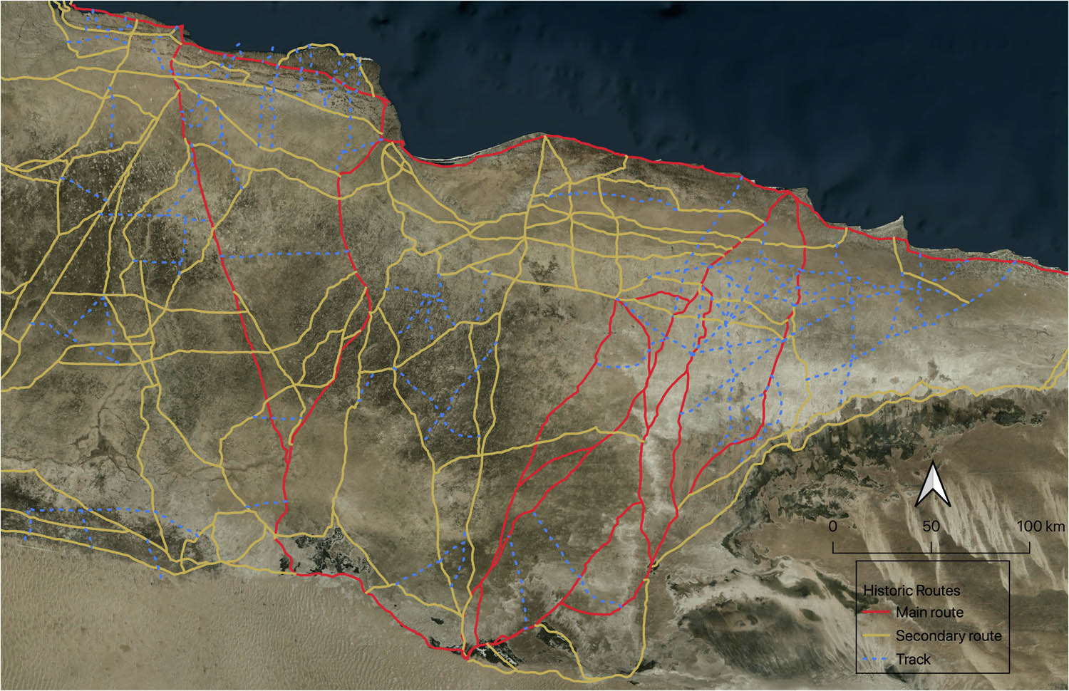
Digitisation of historical routes and traditional paths in Marmarica. This process involved various historical sources and aerial imagery (Basemap © Microsoft).
This process also included the identification of topographic and hydrographic elements, for instance, integrating various digital elevation models (DEMs) and generating the hydrographic network (rivers, wadis, potentially floodable areas, etc.) from them. This highlights the importance of GIS in facilitating a comprehensive evaluation and systematisation of data related to not only archaeological sites and historic routes but also geographic and ecological factors (Figure 5). It additionally enables the analysis of multivariate data, thereby contributing to the reconstruction of how these communities (humans) moved across the landscape, while considering other (non-human) agents that influenced and were involved in these dynamics.
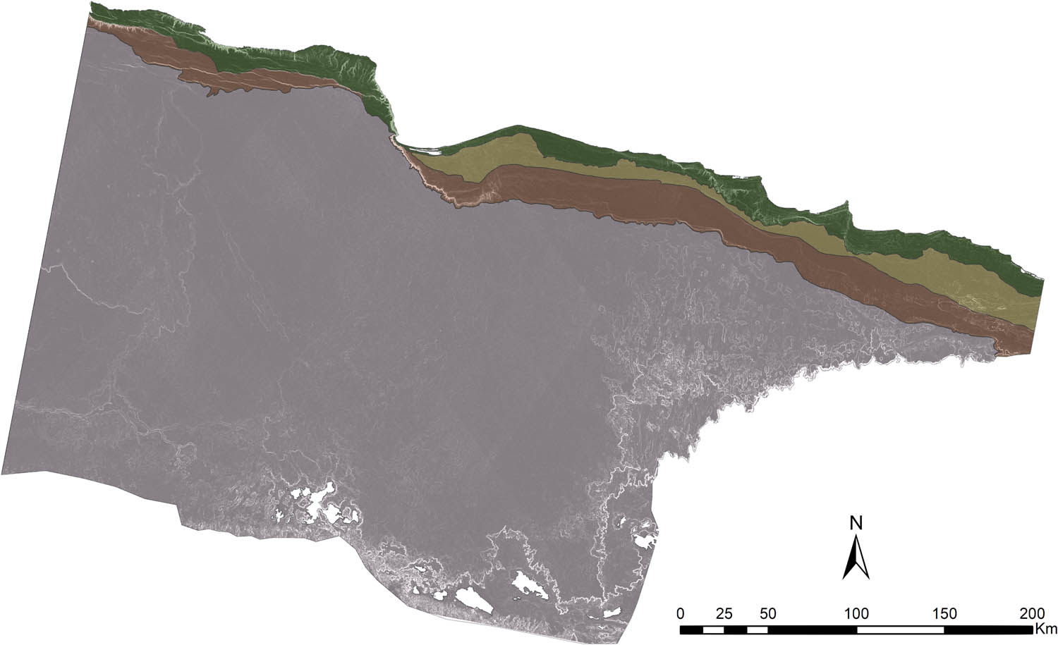
The project delineated the diverse ecological contexts of the Marmarica region, encompassing a range of landscapes defined by the coastal zone, Northern tableland, the Pre-Marmarican Plain, Marmarica Plateau, and desert margins (based on fieldwork conducted on the Eastern Marmarica Plateau in northwestern Egypt (Rieger, 2023)). These contrasting ecosystems contribute to the unique biodiversity and environmental significance of the region as a whole.
3.1.2 (Re)constructing Past Movements
Besides GIS, the specific application of spatial analysis and network research are also fundamental in achieving our aims. Accumulated cost surface analyses have proven to be highly useful, and among them, the use of FMN has yielded highly satisfactory results in several case studies for different contexts (Aceituno & Uriarte, 2019; Déderix, 2016; Fábrega-Álvarez, 2006, 2016; Llobera et al., 2011; Moreno-Navarro, 2022; Pažout, 2017; Stančo & Pažout, 2020; among others). Other methods for reconstructing and studying past movements, such as least cost path, have the limitation of starting from known sites as origins and destination points from which to establish routes (Fábrega-Álvarez & Parcero-Oubiña, 2007; Güimil-Fariña & Parcero-Oubiña, 2015; Maniére, Crépy, & Redon, 2020; Verhagen & Jeneson, 2012; Verhagen, Nuninger, & Groenhuijzen, 2019; among others). Therefore, given that the nature of archaeological data makes our sample always biased and unequal, we tend to overrepresent specific zones within the study area. By contrast, FMN can overcome the limitation of not having high reliability regarding all the archaeological sites in a given region or even not knowing them due to various issues such as lack of reliable dating. As discussed below, this method is based on the application of hydrological and cost–distance analysis tools, resulting in pathways or routes with potential flow accumulation, i.e. movement potential. Additionally, this method allows us to obtain accumulation values that are key to applying network approaches to our data and research aims.
Spatial analysis first requires identifying the factors influencing mobility and the temporal changes in landscapes. Our case encompasses a vast region located in northeastern Africa, predominantly characterised by flat terrain and arid and semi-arid conditions. Consequently, the factors affecting mobility for our study were (i) the physical and topographic characteristics of the terrain surface, such as elevation, slope, and the presence of valleys, plains, and plateaus; and (ii) the hydrographic network, which includes elements such as rivers, water catchment areas, and the presence of wadis (i.e. dry streams or channels with seasonal flood potential typical of arid and semi-arid regions).
After clearly defining the factors affecting mobility for our case, the next step was to establish precise mechanisms to quantify each one. The goal was to create a friction or cost surface map that represents the difficulty of moving across landscapes. In the case of Marmarica, due to its semi-arid and arid conditions, the presence of water catchment areas, wadis, and slopes are particularly relevant to consider (Table 3). Thus, each factor was quantified depending on the spatial context, for, as the principle of heterarchy states, not every agent is equally relevant (in this case, for human mobility); the significance varies according to the spatiality.
Variables that affect mobility in the Marmarica region and the mechanisms to quantify each of them
| Variables | Description |
|---|---|
| Slope | Percentage of slope based on orography |
| Water catchment sources (Cisterns + Wadis with higher potential flooding) | Gradual increase in resistance the further away from water sources, until a maximum value similar to a 10% slope is reached at 5 km from the water points |
| Wadis | Gradual resistance to crossing |
A comprehensive friction or cost surface map should not only represent the physical characteristics of the terrain but also embed a mobility function to simulate movement across different landscapes. This is critical for the model to reflect the complexities of historical mobility accurately. To this end, Naismith’s rule (1982) was applied as a foundational component of the mobility function. This function provides duration estimation by positing that a travel cost (i.e. time and effort) is expected to double for every 12% increase in slope. This rule was instrumental in the calculation of our final friction map, providing a nuanced view of how topography impacts mobility (Figure 6). Our choice is not arbitrary; it is grounded on the recognition that human movement is a key factor influencing mobility along transport routes. Indeed, it is highly likely that the use of packs or draught animals through these routes was accompanied by people on foot (Verhagen et al., 2019), which emphasises the importance of considering human mobility as a key in our analysis. The implications of this are twofold: not only does it acknowledge the role of humans as active agents shaping the landscape through mobility but it also asserts the critical nature of human mobility patterns in our spatial analysis.
Friction map generated by assigning a gradual cost to the hydrographic network depending on the ecological context and calculating the slope from a DEM. Values are represented using a colour categorisation scheme, with lighter shades indicating greater resistance to movement and darker shades indicating lower resistance. Dark-coloured circles indicate water catchment areas.
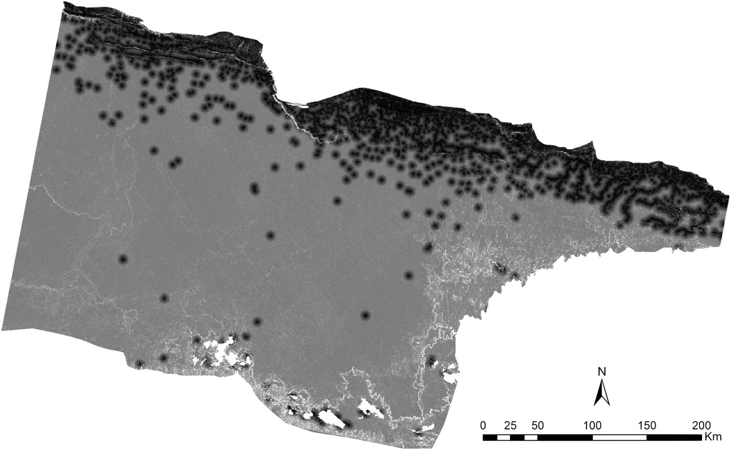
The successful implementation of FMN requires a series of sequential operations following the acquisition of the friction map or surface cost for the region. Initially, it is necessary to generate a mesh or grid of points, which can be achieved by creating a set of random points or an orthogonal layer of uniformly spaced points covering the entire study area (Figure 7). The generated mesh was then associated with a friction map, which was obtained by assigning cost values to each factor (Table 3). The following procedure entails executing a sequence of operations using GIS. The first step involved calculating the distance from each point in the mesh to each pixel with respect to the friction layer generated in the previous step. This is followed by the calculation of the flow direction using hydrological tools based on the cost distance layer calculated in the previous step. Finally, the flow accumulation at each point is computed based on the flow direction. All of these operations can be automated, leading to the generation of a raster layer for each point, in which the pixel value represents the accumulated flow towards that point. To generate the final network using FMN, the mean value of all layers was calculated, resulting in an integrated layer with the values of the accumulated flow, indicating potential circulation (Figure 8).
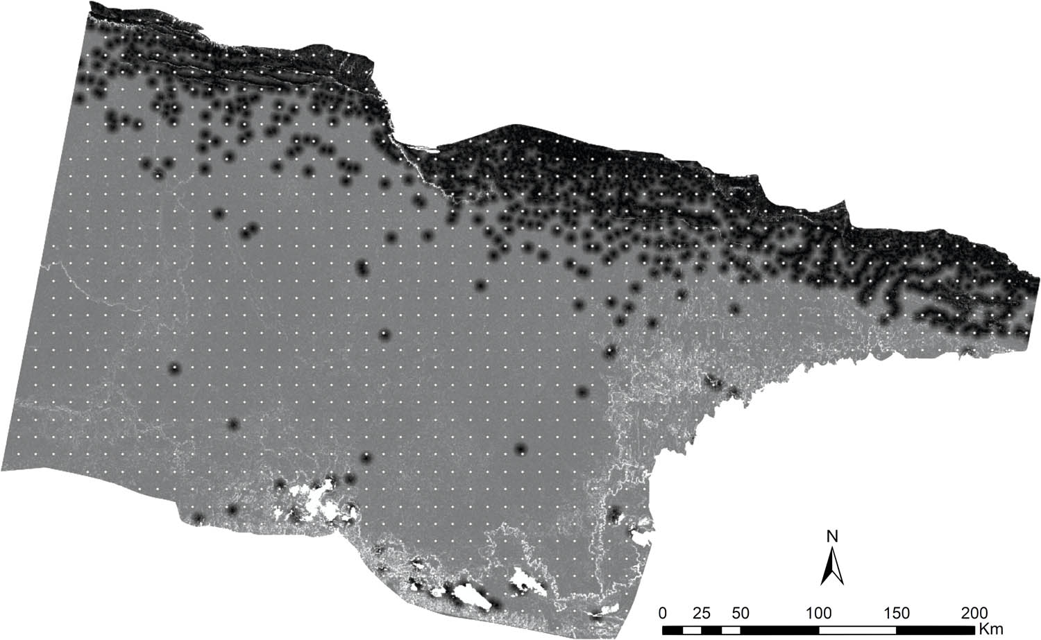
Orthogonal point layer covering the entire study area, with points spaced 10 km apart.
Preliminary results of the application of the FMN. Potential routes are depicted in graduated shades of black based on the accumulation of values obtained.
3.1.3 Exploring Network Dynamics
The aforementioned procedures provide an opportunity to identify pathways or routes with circulation potential. However, our research focused not only on the archaeological study of routes but also on representing and analysing interaction patterns and connectivity within and between the target regions. To achieve this, we employed network approaches to represent our archaeological data as network data, so that it can be analysed and explored. The reconstruction of possible pathways enhances our understanding of the topological structure of the routes within the region under study, while also obtaining accumulation values that allow measuring the strength of connections between different places based on their potential circulation. This is particularly significant in our study, which relies on spatial networks (Brughmans & Peeples, 2020), as connectivity is determined not by the number of connections between specific places but by the intensity of those connections.
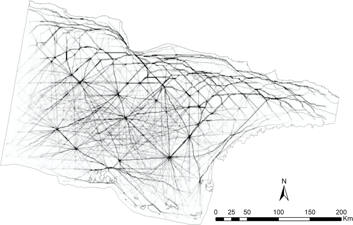
Network science can inform us from additional angles of different patterns and explore the structure of our region’s relationships between places. However, prior to applying network science methods to our data, a sequence of preparatory steps must be carried out. First, it is necessary to review and correct topological errors that may have arisen during the network generated using FMN. These errors include fragmented segments and discontinuous intersections (Figure 8). This process is essential for obtaining a network that generates the least possible distortions when analysed. Second, our research necessitated the development of junction nodes that indicate the points at which each route segment or section ends (Figure 9a). This is because our goal was to study the network structure independently, treating each segment or section as an entity to be analysed.
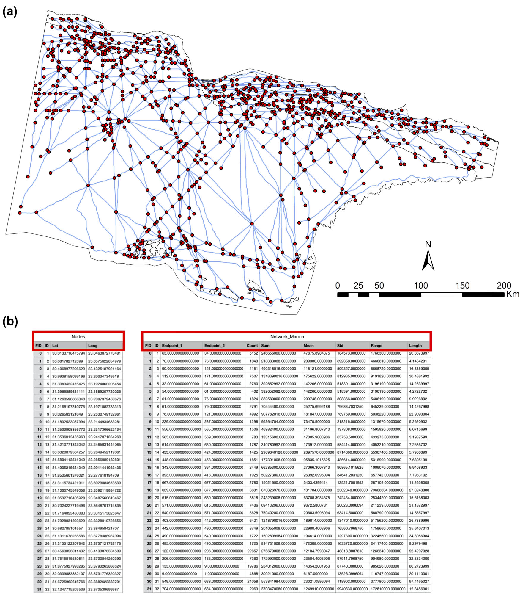
(a) Topological network (in blue) of the Marmarica region obtained by processing results from the FMN approach and generating nodes at each intersection. The endpoint of each route segment is represented as a node (in red). (b) Table showing the different metrics calculated using statistical tools and integrated into network attributes.
The subsequent step involved integrating the corresponding values for each network segment. These values include the area, number of cells, sum, mean, standard deviation, range, and length for each segment (Figure 9b). The statistical analysis tools provided by GIS have allowed their calculation, which in turn allows us to integrate them as attributes associated with our network. In this way, we can correlate both, nodes and metrics, for each segment. The outcome is a layer representing our network for the study region and, most importantly, a network containing all the necessary information to carry out network analysis.
At this stage, we can delve into the exploration of our data using different techniques, simulations, and analyses through network visualisation software (Visone v. 2.24.1) to explore our networks from different configurations and structures (for various methods, see Brughmans et al., 2023; Brughmans & Peeples, 2023). For example, we can explore the role of nodes based on their positions and relationships with others within the network structure (Figure 10).
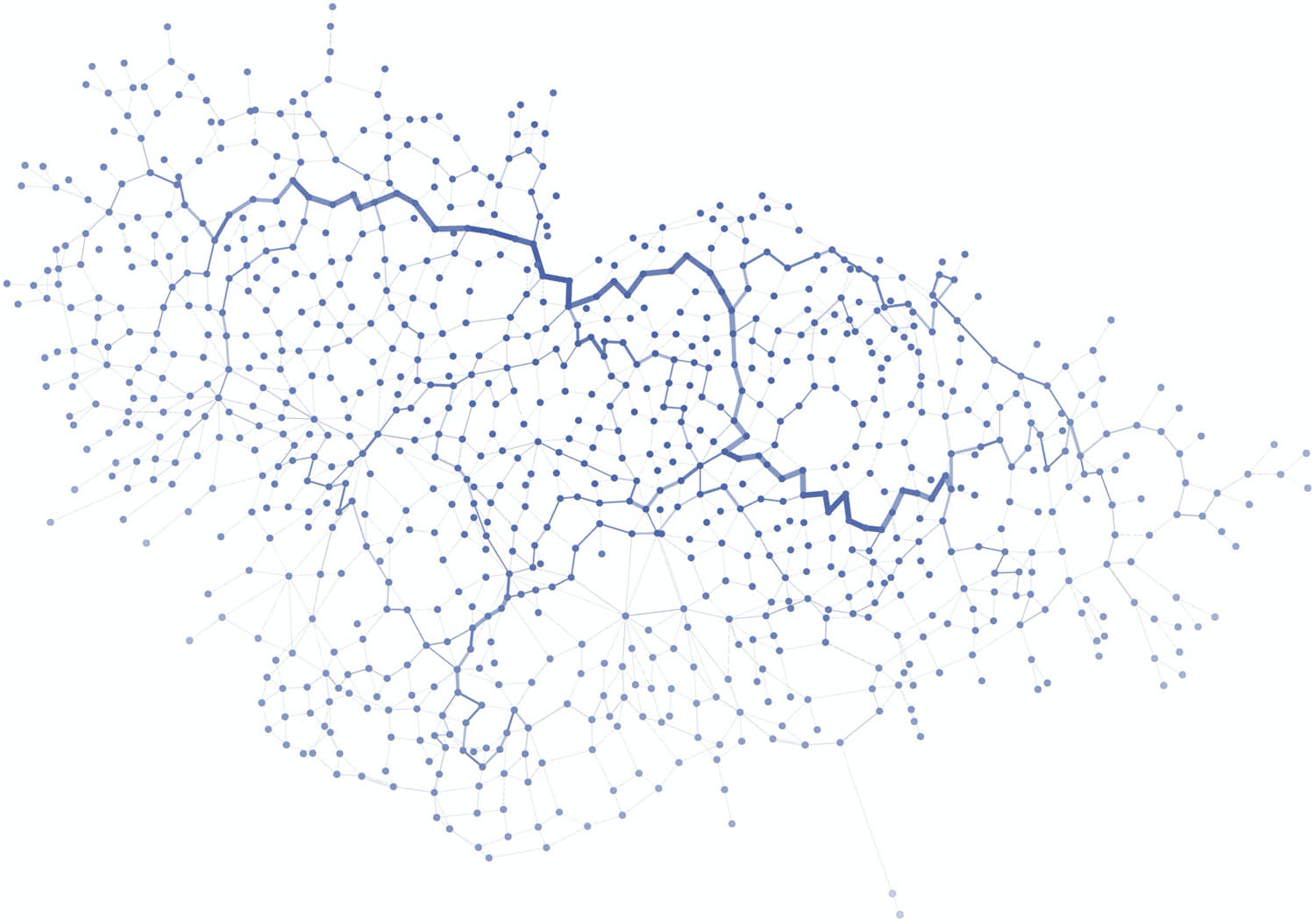
Network representation of the Marmarica region. Nodes (in blue) have been freed from their geographic position, allowing a visualisation based on the strength of their connections and the number of links within the network.
In our approach, the application of centrality measures has provided key insights into the structure and function of a network (Freeman, 1979). Centrality measures, such as “betweenness centrality,” were used to evaluate the influence of a node within the network structure (Figure 11a). This metric allows us to assess the relevance of a node in terms of its position based on the number of times this specific node acts as an intermediary between the nodes. Nodes with high betweenness centrality are considered key points because they are essential for the flow and connection between different areas of the network. Another important centrality measure is “closeness centrality,” which is used to quantify the proximity between nodes (Figure 11b). Nodes with high closeness centrality indicate how close they are to each other and are important for fast and effective communication across the network (Brughmans et al., 2023). Analysing various network metrics was therefore crucial, as they enhanced our understanding of the network dynamics.
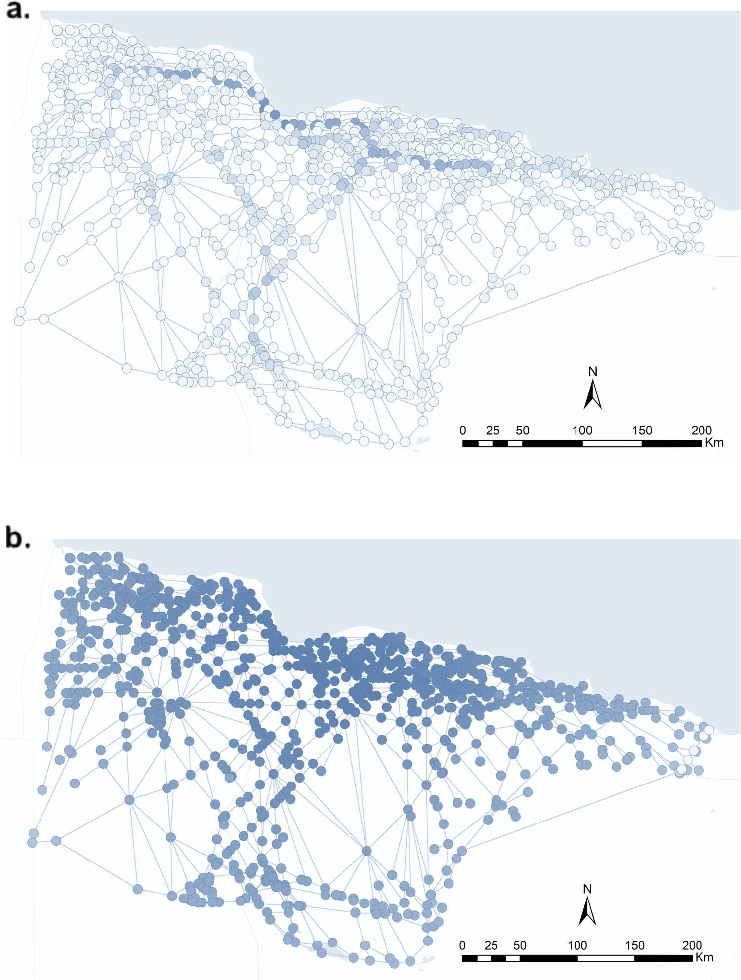
Representation of the mobility network in the Marmarica region with nodes in their geographic position. (a) Nodes are gradually represented according to the betweenness centrality. Higher values are clearly observed along the coast and the central connection towards the inland oasis. (b) Nodes are gradually represented according to the closeness centrality. Higher values are again clearly observed along the coastal area.
4 Results and Discussion
Our results have significantly expanded the available archaeo-historical information on these regions. By using digital research methods and techniques, we were able to reach and cover areas that would otherwise have been inaccessible. This allowed us to exhaustively compile, evaluate, and systematise heritage data published on known archaeological sites as well as locate and record previously unknown sites, such as ancient settlements, burial sites, or historic resource catchment areas. As a result, this has allowed the recording of more than 3,000 archaeological sites, which in turn has shed light on settlement patterns and human occupation within these areas. Moreover, by associating each site with its ecological context, we gained a better understanding of the interrelationships between human and non-human agents across landscapes and the biocultural heritage that they represent. However, the chronological resolution of the data should be considered; it must be noted that certain areas lacked the necessary fieldwork to establish fine-grained chronologies for many of our sites. This may limit the accuracy of our accounts for shorter time periods and requires further investigation.
Our study also obtained significant results regarding mobility and interaction patterns within these regions through spatial analysis and network science. In the case presented in this article, our results demonstrate that coastal areas exhibit greater connectivity than inland zones. Similarly, these areas present a high concentration of multi-period sites that tend to align with regions where mobility is more prominently articulated. This fact is evident in areas surrounding present-day Tobruk in Libya, Sollum and Marsa Matruh in Egypt, and, to a lesser degree, around the oases of Siwa (Egypt), and al-Jaghbub, (Libya). Additionally, we identified connections that followed the north–south and east–west axes between the same coastal areas and the hinterland oasis. These connections are evident from the existence of short-, medium-, and long-distance communication structures (as illustrated in Figures 8, 9, and 11). These results are crucial to the reconstruction of mobility and patterns of interaction, which might have contributed to the development of settlement and subsistence strategies for the communities that moved across these landscapes. The spatial distribution of these concentrated potential routes, compared to the distribution of archaeological sites, suggests a propensity for settling in proximity to key socioeconomic focal points, such as maritime ports, agricultural lands, or the borders of political territories. Consequently, these regions primarily functioned as attractors within a complex network system, facilitating connections with the surrounding territories over the long term.
It is important to note that the mobility model presented does not respond to analyses conditioned by the presence of archaeological remains and rather yielded from independent modelling: sites’ location and distribution were obtained by site mapping through remote aerial survey, whereas our movement model was obtained by applying FMN analyses. Consequently, the results from our modelling have the potential to reflect how movement occurs not just because of human settlements but also due to—in conjunction with—non-human agents. The same reasoning applies to the location of settlements and of the spatial structure as a whole. Thus, the convergence of areas that articulate mobility and of archaeological sites respond to complex patterns of human–non-human entanglements and not just to “simpler” reasons (e.g. this pathway is here because there is a settlement nearby). Our study exemplifies this by applying approaches from complex systems (integrating HE, GIS spatial analysis, and network science) to study past movements and interaction patterns.
Complex systems are characterised by interdependence and feedback between their components, which often exhibit emergent behaviours that cannot be explained by examining individual components in isolation. Connecting with our theoretical framework, this emergence is caused by non-linear dynamics. Think, for instance, how our analyses and models embed ecological zones, terrain relief, settlements, or water catchment areas (some of which are constituted by both humans and non-humans). None of these factors, in isolation or combined in pairs, can explain the spatial structure exhibited by Marmarica. It is rather the summatory combination (non-linearity) of all of them, measured independently and differently (heterarchically), what causes the emergence of new behaviours (in this case, human movement). In our case, the non-linearity of the agents involved in (the emergent behaviour of) mobility has been represented through a network approach.
The movement of people through a series of landscapes can thus be better understood by adopting a complex systems approach. Historical mobility can be understood as complex systems where people’s movements are influenced by a wide range of factors, including social, economic, and environmental. Such an approach points towards understanding migrations as the intertwinement (mutual agency) of human and non-human agents, even in contexts where humans are a priori those who decide (socio-economic reasons). Equally, such an approach enhances our understanding of how these movements influenced their social, spatial, and economic organisations, while considering different geographic and environmental conditions.
Revisiting the Marmarica case study provides a valuable illustration of the underlying theoretical principles and concepts. Our study focused on a vast region with different ecological areas, diverse human communities, and multiple interacting agents. This broad focus is arguably an example reflecting the principles of DONOP. These principles advocate for merging multiple scales, from the local to the supra-regional, to generate a long-term perspective of human–environment interactions. Although this article explicitly focuses on a meso-to-macro level, future work will also allow the integration of local scales. This allows us to reflect on the complex and multidimensional dynamics involved in historical mobility, in our case, chiefly propelled by socioeconomic reasons. We contend that such an integration of multiple chronological and spatial scales to understand movement accounts for different historical cartographies. The interconnectedness of such cartographies, moreover, favours a multi-scale perspective without privileging local over global, or vice versa, and rather supports an analysis of complex dynamics.
Although not stated before, it is also important to note that researchers in HE are committed to generating social outcomes (Costanza et al., 2007; Crumley, 2019; McGovern, 2014; Nelson et al., 2015). This commitment stems from considering that understanding ecosystems from a historical, non-lineal, and entangled perspective might generate insights applicable to the present (Crumley, 2019; Hambrecht et al., 2020; Ray, 2019). The core idea is that a comparative analysis of long-term records of the interactions of human–natural systems might help in the overall effort to understand and ameliorate anthropogenic-driven climate change (Hambrecht et al., 2020). As a preliminary example, our study highlights past ways of movement that are mostly unthinkable in today’s globalist present. The obtained mobility patterns reflect the possibility of moving across harsh landscapes without necessarily producing unsustainable changes in the ecosystem. Human movement can thus be performed without a degrading approach towards non-human agents, but rather through more flexible attitudes – societal development should go together with its ecosystem.
5 Concluding Remarks
This article has discussed some of the core tenets of HE and their potential applicability to the study of landscapes from a complex systems perspective. This topic was explored through a case study, whose main aim was to map past movements across the landscapes of significant regions in the Eastern Mediterranean context. Thus, although this study does not directly focus on understanding human ecodynamics, it is influenced by such an approach. We have also shown some possible areas of applicability by factoring non-humans in the archaeological analysis of plausible landscapes of (mainly) human movement. This does not mean to bluntly equalise humans and non-humans for understanding movement but to recognise the fluid force of agents across a multiplicity of contexts.
Drawing on different authors from the remits of HE and Landscape Archaeology, we have argued that landscapes are complex systems due to their diachronical, synchronical, agency, and phenomenological qualities (Criado-Boado, 2017; Fairclough, 2012; Opitz, Nuninger, & Fruchart, 2012; Van Dyke, 2014). Therefore, HE potentially enhances our conceptualisation of the landscape by envisioning them as historical biocultural constructions that involve the participation of human and non-human agents, which are historical socio-ecosystems (Crumley, 2017; Martín Civantos, 2018; McGlade, 1995). Moreover, this study has expounded how non-linearity and heterarchy enable a non-historicistic understanding of the landscape. Landscapes are not the products of concrete or fixed moments. On the contrary, they are dynamic, in continual, non-lineal, flux; in other words, they are the product of a flowing genealogy (sensu Criado-Boado, 1988) of human–environment entanglements. Mobility, we have claimed, is to be understood as a dynamic involving humans and non-humans. Although movement comprises many aspects of the human past (e.g. phenomenological practices, practical movement, trade and exchange, flow of information and ideas, etc., in sum, human interactions), human–environment entanglements occur here and there, in every process. Therefore, we argue that Mediterranean archaeological research should account for such interrelationships.
Hamilakis expounded in an interview with Pintucci (Hamilakis & Pintucci, 2021) that understanding migrations needs not to focus just on the people-on-the-move but also on the apparatus itself. This study suggests that the same applies to the underlying human–non-human (eco)dynamics. Movement in general, and migrations in particular, always involve human–non-human entanglements and changes within the system that might affect food security, population distribution, etc. Migrations are not just economical, political, or cultural, but biocultural. Movement and related phenomena such as migrations involve multiple species and diverse spatio-temporal contexts. The entanglement of all this, as well as its impacts, should be accounted for in our narratives. The patterns of interactions shown in this article reflect this and open the possibility of considering the influence movement might have on human and non-human populations or the impacts brought about (e.g. traditional approaches to movement and their impacts on food security, etc.). Thus, there are compelling socio-ecological arguments for considering in our present the impact of movement and migrations from a historical fashion.
Acknowledgments
We are thankful to Maurizio Toscano, from the Spanish Foundation for Science and Technology (FECYT); Pau de Soto, from the Autonomous University of Barcelona; Borja Legarra Herrero, from the Institute of Archaeology at UCL; Tom Brughmans, from UrbNet at Aarhus University; Fernando Moreno-Navarro from the University of Carlos III, and Carlos Rodríguez-Rellán, from the University of Granada, for their invaluable contributions to this project. We are also grateful to the editorial team and two anonymous reviewers for their useful comments and for enhancing the overall manuscript.
-
Funding information: The PERAIA Project: Landscapes, Networks, and Society along the ancient Libyan Sea has been funded by the Spanish Ministry of Universities (FPU17/06503) and the Vice-Rectorate for Research and Knowledge Transfer of the University of Granada (Ref: PPJIB2020.18).
-
Author contributions: This article has been written collaboratively by both authors.
-
Conflict of interest: The authors state no conflict of interest.
-
Data availability statement: All the data and associated information are available at https://peraia.ugr.es/gazetteer/ and https://zenodo.org/record/7678852.
References
Aceituno, F. J., & Uriarte, A. (2019). Conectando un territorio: Simulación de rutas de movilidad entre cazadores-recolectores y primeros cultivadores. El caso del Cauca medio (Macizo Volcánico, Colombia), inéditos procedentes del cementerio parroquial de Carabanchel Bajo (Madrid). Estudios de Prehistoria y Arqueología Madrileñas, 12, 175–192.Search in Google Scholar
Acosta Naranjo, R., & P. Domínguez, G. (2014). Ecoantropología: Hacia Un Enfoque Holista de Las Relaciones Ambiente-Sociedad. In A. Andreu Tomàs, Y. Bodoqué Puerta, D. C. d’Argemir i Cendra, J. J. Pujadas Muñoz, J. Roca Girona & M. Soronellas Masdeu (Eds.), Periferias, Fronteras y Diálogos. Actas del XIII Congreso de Antropología de La Federación de Asociaciones de Antropología Del Estado Español. Tarragona, 2–5 de septiembre de 2014 (pp. 2835–2858). Tarragona: Universitat Rovira i Virgili.Search in Google Scholar
Ashmore, W., & Knapp, A. B. (1999). Archaeologies of landscape: Contemporary perspectives. New Jersey, USA: Blackwell Publishers.Search in Google Scholar
Barruezo-Vaquero, P., & Laguna-Palma, D. (2022). On the integration of landscape archaeology within the framework of human ecodynamics – Some theoretical considerations. In E. Dogǎn, M. Pinto Leitão Pereira, O. Antczak, M. Lin, P. Thompson & C. Alday (Eds.), Diversity in archaeology. Proceedings of the Cambridge Annual Student Archaeology Conference 2020/2021 (pp. 339–359). Oxford: Archaeopress.10.2307/j.ctv2ws537m.35Search in Google Scholar
Bauer, A. M. (2018). Questioning a Posthumanist political ecology: Ontologies, environmental materialities, and the political in Iron age South India. Archaeological Papers of the American Anthropological Association, 29, 157–174. doi: 10.1111/apaa.12104.Search in Google Scholar
Bauer, A. M., & Ellis, E. C. (2018). The Anthropocene divide: Obscuring understanding of social-environmental change. Current Anthropology, 59, 209–227. doi: 10.1086/697198.Search in Google Scholar
Brughmans, T., & Peeples, M. A. (2020). Spatial networks. In M. Gillings, P. Hacıgüzeller, & G. Lock (Eds.), Archaeological spatial analysis: A methodological guide (pp. 273–295). Routledge.10.4324/9781351243858-15Search in Google Scholar
Brughmans, T., Mills, B. J., Munson, J. L., & Peeples, M. A. (Eds.). (2023). The Oxford handbook of archaeological network research. Oxford: Oxford University Press.10.1093/oxfordhb/9780198854265.001.0001Search in Google Scholar
Brughmans, T., & Peeples, M.A. (2023). Network science in archaeology. Cambridge: Cambridge University Press.10.1017/9781009170659Search in Google Scholar
Cooper, J. (2022). Beyond the Nile: Long term patterns in Nomad-State interactions across northeast Africa. Mare Nostrum, 13(1), 37–86. doi: 10.11606/issn.2177-4218.v13i1p37-86.Search in Google Scholar
Costanza, R., Steffen, W., Crumley, C., Dearing, J., Hibbard, K., Leemans, R., … Schimel, D. (2007). Sustainability or collapse: What can we learn from integrating the history of humans and the rest of nature. Ambio, 36, 522–527. doi: 10.1579/0044-7447(2007)36[522:socwcw]2.0.co;2.Search in Google Scholar
Crellin, R., & Harris, O. J. T. (2021). What difference does posthumanism make?. Cambridge Archaeological Journal, 31(3), 469–475. doi: 10.1017/S0959774321000159.Search in Google Scholar
Criado-Boado, F. (1988). Arqueología del paisaje y espacio megalítico en Galicia. Arqueología Espacial, 12, 61–118.Search in Google Scholar
Criado-Boado, F. (2017). A paisaxe como enxeñería inversa da materia e a memoria. In M. García Miraz (Coord.), Paisaxe e patrimonio: Un percorrido polo territorio a través do Arquivo de Galicia (pp. 147–157). Santiago de Compostela: Secretaría Xeral de Cultura.Search in Google Scholar
Crumley, C. L. (Ed.). (1994a). Historical ecology. Cultural knowledge and changing landscapes. Santa Fe, New Mexico, USA: School of American Research Advanced Press.Search in Google Scholar
Crumley, C. L. (1994b). Historical ecology: A multidimensional ecological orientation. In C. L. Crumley (Ed.), Historical ecology. Cultural knowledge and changing landscapes (pp. 1–16). Santa Fe, New Mexico, USA: School of American Research Advanced Press.Search in Google Scholar
Crumley, C. L. (2017). Historical ecology and the study of landscape. Landscape Research, 42, 65–73. doi: 10.1080/01426397.2017.1399994.Search in Google Scholar
Crumley, C. L. (2019). Afterword: Integrating time and space in dynamic systems. In C. Ray & M. Fernández-Götz (Eds.), Historical ecologies, heterarchies and transtemporal landscapes. Introductory perspectives (pp. 287–297). London: Routledge.10.4324/9781351167727-17Search in Google Scholar
Daems, D. (2021). Social complexity and complex systems in archaeology. New York and London: Routledge.10.4324/9781003036968Search in Google Scholar
David, B., & Thomas, J. (2016). Landscape archaeology: Introduction. In B. David & J. Thomas (Eds.), Handbook of landscape archaeology (pp. 27–44). New York and London: Routledge.10.4324/9781315427737Search in Google Scholar
Déderix, S. (2016). Traveling across archaeological landscapes: The contribution of Hierarchical Communication Networks. In S. Campana (Ed.), CAA2015. Keep the revolution going. Proceedings of the 43rd Computer Applications and Quantitative Methods in Archaeology annual conference (pp. 555–565). Oxford: Archaeopress.Search in Google Scholar
Egeler, M. (2019). Introduction: ‘Landscape’, ‘Myth’, and the North-Western European Perspective. In M. Egeler (Ed.), Landscape and myth in North-Western Europe (pp. 1–24). Belgium: Brepols.10.1484/M.BBL.5.115988Search in Google Scholar
Eriksson, O., Ekblom, A., Lane, P., Lennartsson, T., & Lindholm, K-J. (2018). Concepts for integrated research in historical ecology. In C. Crumley, T. Lennartsson, & A. Westin (Eds.), Issues and concepts in historical ecology. The past and future of landscapes and regions (pp. 145–181). Cambridge: University Cambridge Press.10.1017/9781108355780.006Search in Google Scholar
Fábrega-Álvarez, P. (2006). Moving without destination. A GIS-based determination of routes (optimal accumulation model of movement from a given origin). Archaeological Computing Newsletter, 64, 7–11.Search in Google Scholar
Fábrega-Álvarez, P., & Parcero-Oubiña, C. (2007). Proposals for an archaeological analysis of pathways and movement. Archeologia e Calcolatori, 18, 121–140.Search in Google Scholar
Fábrega-Álvarez, P. (2016). Un alto en el camino. Notas acerca del uso de SIG en los análisis de movilidad en arqueología. In M. C. Mínguez y E. Capdevilla (Ed.), Manual de Tecnologías de la Información Geográfica aplicadas a la Arqueología (pp. 161–182). Madrid: Comunidad de Madrid.Search in Google Scholar
Fairclough, G. (2012). Look the Other Way – From a branch of archaeology to a root of landscape studies. In S. Kluiving & E. Guttmann-Bond (Eds.), Landscape archaeology between art and science (pp. 471–485). Amsterdam: Amsterdam University Press.10.1017/9789048516070.034Search in Google Scholar
Fitzhugh, B., Butler, V. L., Bovy, K. M., & Etnier, M. A. (2018). Human ecodynamics: A perspective for the study of long-term change in socioecological systems. Journal of Archaeological Science: Reports, 23, 1077–1094. doi: 10.1016/j.jasrep.2018.03.016.Search in Google Scholar
Freeman, L. C. (1979). Centrality in social networks conceptual clarification. Social Networks, 1(3), 215–239.10.1016/0378-8733(78)90021-7Search in Google Scholar
Giacomorra, M. (2006). I Pastori Delle Madonie: Ambiente, Tecniche, Società. Palermo: Fondazione Ignazio Buttitta.Search in Google Scholar
Güimil-Fariña, A., & Parcero-Oubiña, C. (2015). Dotting the joins’: A non-reconstructive use of Least Cost Paths to approach ancient roads. The case of the Roman roads in the nw Iberian Peninsula. Journal of Archaeological Science, 54, 31–44. doi: 10.1016/j.jas.2014.11.030.Search in Google Scholar
Grosskopf, B., & Rieger, A. K. (2019). Buried in the Village: Skeleton Finds in a Graeco-Roman Settlement at Wadi Umm El-Ashdan, NW-Egypt. Anthropologie (Brno), 57(1), 53–67.10.26720/anthro.19.02.15.2Search in Google Scholar
Hambrecht, G., Anderung, C., Brewington, S., Dugmore, A., Edvardsson, R., Feeley, F., … McGovern, T. H. (2020). Archaeological sites as distributed long-term observing networks of the past (DONOP). Quaternary International, 549, 218–226. doi: 10.1016/j.quaint.2018.04.016.Search in Google Scholar
Hamilakis, Y., & Pintucci, A. (2021). Politics, migration, and race: A conversation with Yannis Hamilakis. EX-NOVO: A Journal of Archaeology, 6, 233–238. doi: 10.32028/vol6isspp233.Search in Google Scholar
Harrison, R., & Maher, R. H. (Eds.). (2014). Human ecodynamics in the North Atlantic: A collaborative model of humans and nature through space and time. Maryland: Lexington Books.Search in Google Scholar
Hulin, L. (2008). Western Marmarica Coastal Survey 2008: A preliminary report. Libyan Studies, 39, 299–314. doi: 10.1017/S0263718900010116.Search in Google Scholar
Hulin, L., Timby, J., Muftah, A. M., & Mutri, G. (2010). Western Marmarica Coastal Survey 2010: Preliminary report. Libyan Studies, 41, 155–162. doi: 10.1017/S0263718900000315.Search in Google Scholar
Hulin, L., Timby, J., & Mutri, G. (2009). The Western Marmarica Coastal Survey 2009: Preliminary report. Libyan Studies, 40, 179–187. doi: 10.1017/S0263718900004568.Search in Google Scholar
Ingerson, A. E. (1994). Tracking and testing the nature/culture dichotomy in Practice. In C. Crumley (Ed.), Historical ecology. Cultural knowledge and changing landscapes (pp. 43–66). Santa Fe, New Mexico, USA: School of American Research Advanced Press.Search in Google Scholar
Ingold, T. (1993). The temporality of the landscape. World Archaeology, 25(2), 152–174. doi: 10.1080/00438243.1993.9980235 Search in Google Scholar
Johnson, M. (2012). Phenomenological approaches in landscape archaeology. Annual Review of Anthropology, 41, 269–284. doi: 10.1146/annurev-anthro-092611-145840.Search in Google Scholar
Kirch, P. (2005). Archaeology and global change: The Holocene record. Annual Review of Environment and Resources, 30, 409–440. doi: 10.1146/annurev.energy.29.102403.140700.Search in Google Scholar
Kowalczyk, Z. (2020). Landscape as a network. Archaeological and ethnographic approaches to the Dewil Valley, Palawan, Philippines. Poznan: Faculty of Archaeology. Adam Mickiewicz University in Poznań.Search in Google Scholar
Lethbridge, E., & Hartman, S. (2016). Inscribing environmental memory in the Icelandic sagas and the Icelandic saga map. Publications of the Modern Language Association of America, 131, 381–391.10.1632/pmla.2016.131.2.381Search in Google Scholar
Llobera, M., Fábrega-Álvarez, P., & Parcero-Oubiña, C. (2011). Order in movement: A GIS approach to accessibility. Journal of Archaeological Science, 38(4), 843–851. doi: 10.1016/j.jas.2010.11.006.Search in Google Scholar
Maher, R. H., & Harrison, R. (2014). Humans – A force of nature. In R. Harrison & R. H. Maher (Eds.), Human ecodynamics in the North Atlantic: A collaborative model of humans and nature through space and time (pp. 1–21). Maryland: Lexington Books.Search in Google Scholar
Malpica Cuello, A. (2009). Una propuesta de análisis de la Arqueología del Paisaje. Reflexiones teóricas y un caso concreto de aplicación. Tudmir, 1, 9–28.Search in Google Scholar
Maniére, L., Crépy, M., & Redon, B. (2020). Geospatial data from the ‘Building a model to reconstruct the Hellenistic and Roman road networks of the Eastern desert of Egypt, a semi-empirical approach based on modern travelers’ itineraries. Journal of Open Archaeology Data, 8, 7. doi: 10.5334/joad.71.Search in Google Scholar
Marquardt, W. H. (2019). Dialectic in historical ecology. In C. Ray & M. Fernández-Götz (Eds.), Historical Ecologies, Heterarchies and Transtemporal Landscapes. Introductory perspectives (pp. 11–31). London: Routledge.10.4324/9781351167727-2Search in Google Scholar
Martín Civantos, J. M. (2008). Arqueología y recursos naturales: Notas para la Arqueología del Paisaje. In J. M. Martín Civantos (Ed.), Medio ambiente y Arqueología medieval (pp. 17–40). Granada: Alhulia.Search in Google Scholar
Martín Civantos, J. M. (2009). Estudio arqueológico del paisaje en la cara norte de Sierra Nevada y tierra de Guadix durante la época medieval. In A. Malpica Cuello (Ed.), Análisis de los paisajes históricos. De al-Andalus a la sociedad feudal (pp. 81–103). Granada: Alhulia.Search in Google Scholar
Martín Civantos, J. M. (2011). Working in landscape archaeology: The social and territorial significance of the agricultural revolution in al‐Andalus. Early Medieval Europe, 19(4), 385–410. doi: 10.1111/j.1468-0254.2011.00329.x.Search in Google Scholar
Martín Civantos, J. M. (2018). La Arqueología del Paisaje como lugar donde hacer realmente compleja nuestra disciplina’. In J. A. Quirós Castillo (Ed.), Treinta años de Arqueología medieval en España (pp. 205–224). Oxford: Archaeopress.10.2307/j.ctv1zcm12b.12Search in Google Scholar
McGlade, J. (1995). Archaeology and the ecodynamics of human-modified landscapes. Antiquity, 69, 113–132. doi: 10.1017/S0003598X00064346.Search in Google Scholar
McGovern, T. H. (2014). North Atlantic human ecodynamics research: Looking forward from the past. In R. Harrison & R. H. Maher (Eds.), Human ecodynamics in the North Atlantic: A collaborative model of humans and nature through space and time (pp. 213–223). Maryland: Lexington Books.Search in Google Scholar
McGovern, T. H., Hambrecht, G., & Hicks, M. (2019). Historical ecology and longitudinal research strategies around lake Mývatn, Iceland. In C. Ray & M. Fernández-Götz (Eds.), Historical ecologies, heterarchies and transtemporal landscapes. Introductory perspectives (pp. 32–42). London: Routledge.10.4324/9781351167727-3Search in Google Scholar
Meyer, W., & Crumley, C. (2011). Historical ecology: Using what works to cross the divide. In T. Moore & L. Armada (Eds.), Atlantic Europe in the first millennium BC: Crossing the divide (pp. 109–134). Oxford: Oxford University Press.10.1093/acprof:osobl/9780199567959.003.0003Search in Google Scholar
Milek, K. (2018). Transdisciplinary archaeology and the future of archaeological practice: Citizen science, portable science, ethical science. Norwegian Archaeological Review, 51, 36–47.10.1080/00293652.2018.1552312Search in Google Scholar
Moreland, J. (2010). Archaeology, theory and the middle ages: Understanding the early Medieval past. Bristol: Bristol Classical Press.10.5040/9781849668606Search in Google Scholar
Moreno-Navarro, F. (2022). Simulación y análisis del sistema de transporte en el norte de la Carpetania romana. Una aproximación desde los SIG y análisis de redes. Zephyrus, LXXXIX, 191–211.10.14201/zephyrus202289191211Search in Google Scholar
Naismith, W. W. (1892). Cruach Ardran, Stobinian, and Ben More. The Scottish Mountaineering Club Journal, 2(3), 135–136.Search in Google Scholar
Nelson, M. C., Ingram, S. E., Dugmore, A. J., Streeter, R., Peeples, M. A., McGovern, T. H., … Smiarowski, K. (2015). Climate challenges, vulnerabilities, and food security. Proceedings of the National Academy of Sciences, 113, 298–303.10.1073/pnas.1506494113Search in Google Scholar
Nielsen, N. (2017). Cereal cultivation and nomad-sedentary interactions at the Late Bronze Age Settlement of Zawiyet Umm el-Rakham. Antiquity, 91(360), 1561–1573. doi: 10.15184/aqy.2017.174.Search in Google Scholar
Opitz, R., Nuninger, L., & Fruchart, C. (2012). Thinking topographically about the landscape around Besançon (Doubs, France): From a multi- to an interdisciplinary approach. In S. Kluiving & E. Guttmann-Bond (Eds.), Landscape archaeology between art and science (pp. 395–412). Amsterdam: Amsterdam University Press.10.1017/9789048516070.029Search in Google Scholar
Oxford English Dictionary. (2023). Migration. https://www.oed.com/view/Entry/118324?redirectedFrom=migration#eid.Search in Google Scholar
Pažout, A. (2017). The roman road system in the Golan: Highways, Paths and Tracks in quotidian life. Journal of Landscape Ecology, 10(3), 11–24. doi: 10.1515/jlecol-2017-0022.Search in Google Scholar
Ray, C. (2019). Historical ecologies, heterarchies and transtemporal landscapes. Introductory perspectives. In C. Ray & M. Fernández-Götz (Eds.), Historical ecologies, heterarchies and transtemporal landscapes. Introductory perspectives (pp. 1–8). London: Routledge.10.4324/9781351167727-1Search in Google Scholar
Ray, N., & Nikolaus, J. (2022). Changing urban environments and the impact on coastal cultural heritage at Marsa Matruh, Egypt. Journal of Maritime Archaeology, 17, 445–464. doi: 10.1007/s11457-022-09337-0.Search in Google Scholar
Rayne, L., Bradbury, J., Mattingly, D., Philip, G., Bewley, R., & Wilson, A. (2017). From above and on the ground: Geospatial methods for recording endangered archaeology in the Middle East and North Africa. Geosciences, 7(4), 100. doi: 10.3390/geosciences7040100.Search in Google Scholar
Rieger, A.-K. (2017). The various ways of being mobile: Habitual knowledge, life-strategies and the ancient route networks on the Eastern Marmarica-Plateau (Northern Libyan Desert). Open Archaeology, 3, 49–68. doi: 10.1515/opar-2017-0003.Search in Google Scholar
Rieger, A.-K. (2019). ‘Un-Central’ landscapes of NE-Africa and W-Asia – Landscape archaeology as a tool for socio-economic history in arid landscapes. Land, 8(1). doi: 10.3390/land8010001.Search in Google Scholar
Rieger, A.-K. (2023). Water as a problem and a solution in arid landscapes: Resilient practices and adapted land use in the Eastern Marmarica (NW-Egypt) between the 2nd Millennium BCE and the 1st Millennium CE. Land, 12(5), 1109. doi: 10.3390/land12051109.Search in Google Scholar
Sinclair, P., Moen, J., & Crumley, C. (2018). Historical ecology and the longue durée. In C. Crumley, T. Lennartsson, & A. Westin (Eds.), Issues and concepts in historical ecology. The past and future of landscapes and regions (pp. 13–40). Cambridge: University Cambridge Press.10.1017/9781108355780.002Search in Google Scholar
Snape, S. (2003). New perspectives on distant horizons: Aspects of Egyptian imperial administration in Marmarica in the Late Bronze Age. Libyan Studies, 34, 1–8. doi: 10.1017/S026371890000337X.Search in Google Scholar
Stančo, L., & Pažout, A. (2020). Which way to Roxane: Mobility networks in the heartland of Central Asia. Journal of Archaeological Science: Reports, 32, 102391, 1–13. doi: 10.1016/j.jasrep.2020.102391.Search in Google Scholar
Tello, E. (1999). La formación histórica de los paisajes agrarios mediterráneos: Una aproximación coevolutiva. Historia Agraria, 19, 195–212.Search in Google Scholar
Trigger, B. G. (1967). Settlement archaeology. Its goals and promise. American Antiquity, 32, 149–160. doi: 10.2307/277900.Search in Google Scholar
Van Dyke, R. M. (2014). Phenomenology in archaeology. In C. Smith (Ed.), Encyclopedia of global archaeology (pp. 5909–5917). New York: Springer.10.1007/978-1-4419-0465-2_295Search in Google Scholar
Verhagen, P., & Jeneson, K. (2012). A Roman puzzle. Trying to find the via Belgica with GIS. In A. Chrysanthi, P. Murrieta, & y. C. Papadopoulus (Eds.), Thinking beyond the Tool: Archaeological computing & the interpretive process (pp. 123–130). Oxford: Archaeopress, BAR International Series, 2344.Search in Google Scholar
Verhagen, P., Nuninger, L., & Groenhuijzen, M. R. (2019). Modelling of pathways and movement networks in archaeology: An overview of current approaches. In P. Verhagen, J. Joyce, & M. R. Groenhuijzen (Eds.), Finding the limits of the limes. Modelling demography, economy and transport on the edge of the Roman empire (pp. 217–251). Luxemburg: Springer.10.1007/978-3-030-04576-0_11Search in Google Scholar
Vetter, T., Rieger, A. K., & Nicolay, A. (2014). Disconnected runoff contributing areas: Evidence provided by ancient watershed management systems in arid north-Eastern Marmarica (NW-Egypt). Geomorphology, 212, 41–57. doi: 10.1016/j.geomorph.2013.10.002.Search in Google Scholar
Wilson, A. (2021). The use of remote sensing and digital tools for cultural heritage management and archaeological research. Levant, 53(3), 384–388. doi: 10.1080/00758914.2022.2051901.Search in Google Scholar
Winterhalder, B. P. (1994). Concepts in historical ecology: The view from evolutionary theory. In C. L. Crumley (Ed.), Historical ecology. Cultural knowledge and changing landscapes (pp. 17–42). Santa Fe, New Mexico, USA: School of American Research Advanced Press.Search in Google Scholar
© 2023 the author(s), published by De Gruyter
This work is licensed under the Creative Commons Attribution 4.0 International License.
Articles in the same Issue
- Regular Articles
- A 2D Geometric Morphometric Assessment of Chrono-Cultural Trends in Osseous Barbed Points of the European Final Palaeolithic and Early Mesolithic
- Wealth Consumption, Sociopolitical Organization, and Change: A Perspective from Burial Analysis on the Middle Bronze Age in the Carpathian Basin
- Everything Has a Role to Play: Reconstruction of Vessel Function From Early Copper Age Graves in the Upper Tisza Region (Eastern Hungary)
- Urban Success and Urban Adaptation Over the Long Run
- Exploring Hypotheses on Early Holocene Caspian Seafaring Through Personal Ornaments: A Study of Changing Styles and Symbols in Western Central Asia
- Victims of Heritage Crimes: Aspects of Legal and Socio-Economic Justice
- On the (Non-)Scalability of Target Media for Evaluating the Performance of Ancient Projectile Weapons
- Small Houses of the Dead: A Model of Collective Funerary Activity in the Chalcolithic Tombs of Southwestern Iberia. La Orden-Seminario Site (Huelva, Spain)
- Bigger Fish to Fry: Evidence (or Lack of) for Fish Consumption in Ancient Syracuse (Sicily)
- Terminal Ballistics of Stone-Tipped Atlatl Darts and Arrows: Results From Exploratory Naturalistic Experiments
- First Archaeological Record of the Torture and Mutilation of Indigenous Mapuche During the “War of Arauco,” Sixteenth Century
- The Story of the Architectural Documentation of Hagia Sophia’s Hypogeum
- Iconographic Trends in Roman Imperial Coinage in the Context of Societal Changes in the Second and Third Centuries CE: A Small-Scale Test of the Affluence Hypothesis
- Circular Economy in the Roman Period and the Early Middle Ages – Methods of Analysis for a Future Agenda
- New Insights Into the Water Management System at Tetzcotzinco, Mexico
- How Linguistic Data Can Inform Archaeological Investigations: An Australian Pilot Study Around Combustion Features
- Leadership in the Emergent Baekje State: State Formation in Central-Western Korea (ca. 200–400 CE)
- Middle Bronze Age Settlement in Czeladź Wielka – The Next Step Toward Determining the Habitation Model, Chronology, and Pottery of the Silesian-Greater Poland Tumulus Culture
- On Class and Elitism in Archaeology
- Archaeology of the Late Local Landscapes of the Hualfín Valley (Catamarca, Argentina): A Political Perspective from Cerro Colorado of La Ciénaga de Abajo
- Review Article
- The State of the Debate: Nuragic Metal Trade in the Bronze Age and Early Iron Age
- A Review of Malta’s Pre-Temple Neolithic Pottery Wares
- Commentary Article
- Paradise Found or Common Sense Lost? Göbekli Tepe’s Last Decade as a Pre-Farming Cult Centre
- Special Issue Published in Cooperation with Meso’2020 – Tenth International Conference on the Mesolithic in Europe, edited by Thomas Perrin, Benjamin Marquebielle, Sylvie Philibert, and Nicolas Valdeyron - Part II
- The Time of the Last Hunters: Chronocultural Aspects of Early Holocene Societies in the Western Mediterranean
- Fishing Nets and String at the Final Mesolithic and Early Neolithic Site of Zamostje 2, Sergiev Posad (Russia)
- Investigating the Early-to-Late Mesolithic Transition in Northeastern Italy: A Multifaceted Regional Perspective
- Socioeconomic, Technological, and Cultural Adaptation of the Mesolithic Population in Central-Eastern Cantabria (Spain) in the Early and Middle Holocene
- From Coastal Sites to Elevated Hinterland Locations in the Mesolithic – Discussing Human–Woodland Interaction in the Oslo Fjord Region, Southeast Norway
- Exploitation of Osseous Materials During the Mesolithic in the Iron Gates
- Motorways of Prehistory? Boats, Rivers and Moving in Mesolithic Ireland
- Environment and Plant Use at La Tourasse (South-West France) at the Late Glacial–Holocene Transition
- Stylistic Study of the Late Mesolithic Industries in Western France: Combined Principal Coordinate Analysis and Use-Wear Analysis
- Mesolithic Occupations During the Boreal Climatic Fluctuations at La Baume de Monthiver (Var, France)
- Pressure Flakers of Late Neolithic Forest Hunter-Gatherer-Fishers of Eastern Europe and Their Remote Counterparts
- The Site Groß Fredenwalde, NE-Germany, and the Early Cemeteries of Northern Europe
- Special Issue on Archaeology of Migration: Moving Beyond Historical Paradigms, edited by Catharine Judson & Hagit Nol
- The Blurry Third Millennium. “Neolithisation” in a Norwegian Context
- Movement or Diaspora? Understanding a Multigenerational Puebloan and Ndee Community on the Central Great Plains
- Human Mobility and the Spread of Innovations – Case Studies from Neolithic Central and Southeast Europe
- The Thule Migration: A Culture in a Hurry?
- The Transformation of Domes in Medieval Chinese Mosques: From Immigrant Muslims to Local Followers
- Landscapes of Movement Along the (Pre)Historical Libyan Sea: Keys for a Socio-Ecological History
- Arab Migration During Early Islam: The Seventh to Eighth Century AD from an Archaeological Perspective
- Special Issue on Ancient Cultural Routes: Past Transportations Infrastructures as a Two-Way Interaction Between Society and Environment, edited by Francesca Fulminante, Francesca Mazzilli & Franziska Engelbogen
- The Impact of Transportation on Pottery Industries in Roman Britain
- The Role of the Road in Settling a Mountainous Region
- An Example of Geographic Network Analysis: The Case Study of the Fortore Valley (Molise and Apulia, Italy)
- Water, Communication, Sight, and the Location of Fortifications on the Strata Diocletiana (Syria) in Late Antiquity
- Transport, Interaction, and Connectivity
- Special Issue on Scales of Interaction in the Bronze and Iron Age Central Mediterranean, edited by Emily Holt & Davide Schirru
- Tracing Mobility Patterns of Buried Species of the Late Iron Age Funerary Staggered Turriform of Son Ferrer (Calvià, Spain)
- Approaching Interaction in Iron Age Sardinia: Multi-Scalar Survey Evidence from the Sinis Archaeological Project and the Progetto S’Urachi
- From the Atlantic to the Mediterranean and Back: Sardinia, Iberia, and the Transfer of Knowledge in Late Bronze Age Networks
- Special Issue on Bricks Under the Scope: Microscopic and Macroscopic Approaches to the Study of Earthen Architecture, edited by Marta Lorenzon, Moritz Kinzel, & Benjamín Cutillas-Victoria
- Earthen Architecture in Nordic Countries: Future Directions
- Earthen Architecture and Craft Practices of Early Iron Age Ramparts: Geoarchaeological Analysis of Villares de la Encarnación, South-Eastern Iberia
- Earthen Architecture in Southern Algeria: An Assessment of Social Values and the Impact of Industrial Building Practices
- Studying the Use of Earth in Early Architecture of Southwest and Central Asia
- Roof Tiles and Bricks of the Etruscan Domus dei Dolia (Vetulonia, Italy): An Archaeological and Archaeometric Study of Construction Materials
- The Building Blocks of Circular Economies: Rethinking Prehistoric Turf Architecture Through Archaeological and Architectural Analysis
- Undecorated Roman-Period Roof Tiles – An Old Material Providing New Results
- Turf Building in Iceland – Past, Present, and Future
- Special Issue on Past Sounds: New Perspectives in the Field of Archaeoacoustics, edited by Margarita Díaz-Andreu & Neemias Santos da Rosa
- Employing Psychoacoustics in Sensory Archaeology: Developments at the Ancient Sanctuary of Zeus on Mount Lykaion
- One, Two, Three! Can Everybody Hear Me? Acoustics of Roman Contiones. Case Studies of the Capitoline Hill and the Temple of Bellona in Rome
- Ringing Tone and Drumming Sages in the Crevice Cave of Pirunkirkko, Koli, Finland
- Music and Storytelling at Rock Art Sites? The Archaeoacoustics of the Urkosh Area (Russian Altai)
- Listening in Sacred Spaces: The Sanctuary of Poseidonia and Selinunte’s Main Urban Sanctuary
- Presenting Archaeoacoustics Results Using Multimedia and VR Technologies
- Special Issue on Reconsidering the Chaîne Opératoire: Towards a Multifaceted Approach to the Archaeology of Techniques, edited by Marie-Elise Porqueddu, Claudia Sciuto & Anaïs Lamesa
- Reconsidering the Chaîne Opératoire: At the Crossroad Between People and Materials
- Materiality of Plaster Vessels: The Problem of Southwest Asian Neolithic White Ware
- The Chaîne Opératoire Approach for Interpreting Personal Ornament Production: Marble Beads in Copper Age Tuscany (Italy)
- Seriality and Individualization: Carving the Fluted Sarcophagi from Hierapolis of Phrygia
- Making Vessels for the Dead: Pottery-Making Practices, Chaîne Opératoire and the Use of Grog (Crushed Sherds) as a Technological and Cultural Choice during Late and Inca Periods in the Northwestern Argentine Region (Southern Andes)
- An Invention Shading Light to the Socio-History of Bonneuil Quarry Basin: The Roadheaders with Rotating Drill Bits
- The Ugly Duckling: Understanding the Making of an Early Copper Age Atypical Ceramic Vessel from the Great Hungarian Plain
- Synopsis of a Treasure. A Transdisciplinary Study of Medieval Gold Workings Biographies
- Identification of Ceramic Traditions on the Prehistoric Mines of Gavà (Barcelona, Spain)