Transport, Interaction, and Connectivity

Abstract
Transport research is a multidisciplinary field that extends beyond technical aspects. As such, it can provide significant insights into societies, economies, and cultures. In this study, we take a broader perspective that encompasses transport, interaction, and connectivity. These three terms are interconnected, with transport and interaction being interdependent sub-systems. Transport research encompasses means of transport, local, regional, and supra-regional networks, transport infrastructure, and the items transported. In turn, interaction research focusses on interaction networks, groups, and intensities. The concept of connectivity adds a layer of complexity, enabling a better understanding of the sub-systems and the system as a whole by considering the balance of opportunities and limitations. This article aims to demonstrate how the various approaches and concepts are related and to outline an integrated and systematic research approach.
1 Introduction
Imagine a world without transport, teleportation, and telecommunication. Depending on your perspective, the result is either a paradise, without tiring journeys or contact with unpleasant people, or a desolate world without the opportunity to interact with other people beyond your home village. There would be no trade or means of collaboration. Although technical solutions such as telecommunication compensates for this deficiency in parts, in our present world, a lack of transport would be the stuff of nightmares.
Transport is obviously a precondition of many human activities, including mobility, migration, trade, and the exploitation and exploration of natural resources and small-scale agriculture. Transport enables the interaction of spatially separated entities. Connectivity is both a modern buzzword and a concept for certain phenomena emerging in interaction systems. The three terms – transport, interaction, and connectivity – range from concrete and tangible to completely abstract.
The aim of this study is to explore both the interrelationship of the three key terms and the methods for the analysis of these phenomena. The main intention is to move from superficial studies of transport, interaction, and the metaphoric usage of the term connectivity towards an integrated, interdisciplinary, and deep study of relationships beyond the mere networks. However, many methods and concepts for this kind of research are already available and hence, this article is rather a programmatic study than an original research work. The aim of this study is to highlight connections between different terms and concepts as well as ways towards a profound integration of these concepts. As this is a conceptual review article, the reader will look in vain for sections such as method, data and result. Instead, the text focusses on methodological concepts and key terms. The examples are biased by the author’s perspective.
2 Facets of Transport Analysis
Transport is a means of moving people and objects from one place to another. In this way, a metric neighbourhood can be established between people and objects that were previously in different places, thus fulfilling the prerequisite for interaction. Considering the lack of technology providing teleportation and telecommunication in ancient times, transport was the only means of spatial interaction in pre- and protohistory.
Transport involves certain difficulties and effort, and, as a result, the field of archaeology has a long-held interest in evidence of transport. For a systematic approach, different facets of transport archaeology have to be considered: means of transport; roads, routes, and networks; transport infrastructure; and transported objects.
2.1 Means of Transport
Pedestrian transport must be assumed as it leaves little evidence in the archaeological record beyond the presence of shoes. Wagons and the invention of the wheel is an archaeological relevant issue. Wagons are a substantial simplification of traffic and hence, it is no surprise, that the wheel was invented independently in different locations (Kaiser, 2010). The extraordinary importance of wagons is reflected with their role in funerary practice and rites of some cultures, which reflect their importance in everyday life as well (Harbison, 1969; Pare, 1988, 1991). Richly decorated four-wheeled ritual wagons and two-wheeled chariots were used in the Iron Age of Europe and the Mediterranean. Ritual wagons refer to a sphere of ritual and spiritual transport, mostly in the context with religious transitions. Egypt or Celtic chariots (Furger-Günti, 1991; Harbison, 1969; Veldmeijer, 2017) are rather associated with combat. Wagons require draft animals, which are sometimes present in graves. Equestrians also need to be considered (Bliujienė, 2009; Koch, 1999). Horses play an important role for equestrian nomads (Alexeev, 2001).
Ships and boats representing waterborne transport are known from rock art, the decoration of bronze objects, pottery vases, etc., from different times and regions (Kaul, 1998) as well as from shipwrecks (Johnstone, 2013). The most successful type is the logboat used in Europe from the Mesolithic to the twentieth century (Hirte, 1987; McGrail, 1978). Plank boats provide more technological details and more flexibility for shaping the hull. The Hjortspring boat from the Pre-Roman Iron Age and the Nydam boat from the Roman Iron Age are examples of a stepwise technological development and show the transition from the canoe to the rowing boat (Rieck, 1994; Rosenberg, 1937). Both combat vessels represent a strong military component. Specific technical solutions enable us to identify boat building traditions such as ships with sewn planks from the Mediterranean (Kahanov & Pomey, 2004). The strict functional requirements of ships and boats, which are life-threatening if not met, led to a relatively stable typological development of watercraft, where arbitrary attempts are rather rare. Each typological change is due to functional, economic, or social reasons. Social aspects are seen with the late Nordic vessels and the early cogs (Crumlin-Pedersen, 1997; Englert, 2015; Fliedner & Pohl-Weber, 1972). The Nordic ships are built in a traditional way and have larger capacity, while the cogs break with tradition and introduce entirely different people to shipbuilding and navigation. Shipbuilding and naval seafaring become the domain of medieval citizens. The wide range of topics covered with ships and wagons allows us to gain many information on both, transport and society. The means of transport tells us something about transport velocity, capacity, technical skills, and the social integration of transport.
2.2 Roads, Routes, and Networks
The aspect of roads, routes, and networks corresponds with the main topic of this volume, and includes material remains of roads as well as the reconstruction of routes based on indirect evidence (Margary, 1973; Pitz, 1962; Rathmann, 2003; Schneider, 1848; Tilburg, 2007; Vermeulen & Antrop, 2001). These empirical route models result in a network that comprises connections between places with specific features such as length, effort of movement, building costs, suitability for different means of transport, and technical realisation. Three levels are demonstrated in both the empirical and the theoretical network models (Nakoinz & Knitter, 2016, p. 171).
At the local level, networks represent the exact location of pathways. In this case, nodes represent turning points of the pathways and, rarely, occupied places. The edges of the network, the exact pathways are tightly connected to environment in this level. Slope, soil type, wetness, and means of transport determine the location of the pathways. Local level transport networks only make sense as geographical networks mapped in a geographical space. A network always connects nodes with straight (or arbitrary curved if there is no geographical meaning) lines. A least cost path connection would produce a curve between two sites by creating many artificial nodes that do not have a specific meaning beside they are placed on the pathway. Hence, these nodes do not make any sense without the geographical location.
Regional level networks do not focus on the exact location of the connection but on the question of which sites are connected to other sites. Both, geographical and non-geographical network representations can make sense. On the regional level, the nodes are settlements at the starting and end points of interaction processes. The edges are any kind of relationship or interaction. In this case, the edges are either interpreted as roads, pathways, or as measure of the actual interaction. Although the environment has influence on the edges, they are not directly related to the environment in the network model.
The supra-regional level networks represent dominant and abstract interaction patterns. On this level, the nodes do not include certain settlements but rather whole regions represented by a random point inside the region. Accordingly, the edges are not certain connections or roads but rather general routes and communication axes. The supra-regional level represents the general structure of the transport system.
Empirical local level networks can be developed using archaeological road remains, such as hollow ways and paved roads. The research on Roman roads started rather early and is still an important topic (Becker, 1880; Blöck, 2014; Davies, 2002; Margary, 1973). The reasons are diverse. The most important one is the fact that paved Roman roads are more likely to be discovered than roads without this kind of substantial material structure. Furthermore, the dense pattern of Roman archaeological evidence provides a rich context for interpreting the roads.
Nonetheless, paths without a fixed structure are also the subject of archaeological research (Herzog, 2016). In particular, hollow ways can be observed, but since they can be remains from different time periods and are not suitable for scientific dating or typological dating, their chronology is hard to determine. This is completely different for “Moorwege,” wooden paths built to cross bogs, because they offer much better opportunities for dating since they are often preserved in the wet environment (Endlich & Lässig, 2007; Hayen, 1958; Heumüller, 2018). Furthermore, the effort to build these constructions points to highly relevant connections. Similarly, paved street sections can indicate areas of special significance, as is the case at Borremose, a fortified settlement of the pre-Roman Iron Age in Denmark (Martens, 2010).
We also have to consider bridges and transport infrastructure such as fords (Lehnemann, Urz, & Meiborg, 2021) because they indicate roads or pathways. A disputed topic is the reconstruction of pathways using grave mounds. Müller (1904) not only observed that Bronze Age burial mounds form strange linear patterns in Denmark which can be interpreted as ancient pathways but also reconstructed the course of these paths more than 100 years ago. Similar research has been conducted in Schleswig-Holstein (Hinz, 1951; Marschalleck, 1964). This approach was accepted until Renfrew (1973) observed that megalithic tombs are often located at assumed territorial borders. For the Danish monuments, Klassen (2014) demonstrated that the Bronze Age lines frequently aim for fords, and their interpretation as paths is convincing. It is also possible that lines of monuments are both borders and pathways (Faupel, 2021; Faupel & Nakoinz, 2018; Nakoinz & Knitter, 2016). Although roads connect settlements, not all observed road segments are necessarily aiming at settlements. An example are stubways, which extend a network by running between frequently relocated settlement sites and the road system. They enable a stable road system that can coincide with borders.
Accepting the idea that monuments can indicate the location of paths, the next question is how to extract the network from the points. Müller (1904) used an intuitive approach that led to convincing results, but it is not reproducible. A quantitative and reproducible approach is to use neighbourhood graphs (Katajainen & Nevalainen, 1986; Nakoinz & Knitter, 2016, pp. 173–174) for pattern recognition. This approach is sensitive for gaps in the data and assumes that the pathways run exactly along the monuments (Figure 1).

The disadvantages of the neighbourhood graphs are overcome by the density ridge approach (Faupel, 2021; Faupel & Nakoinz, 2018; Nakoinz & Knitter, 2016). The kernel density estimation of the point density of monuments can be used to extract the ridges of the density “mountains,” indicating the lines of the highest point density. This approach was further developed by Franziska Faupel (Engelbogen) who applied this concept to Iron Age cemeteries and analysed the Iron Age transport system in southwest and west Germany and Alsace (Faupel, 2021) (Figure 2).

Density ridge method (Nakoinz & Knitter, 2016, Figure 9.9).
The empirical models show how the ancient pathway network had been. Usually, it is hard to understand why it is this way. To better understand the empirical models, theoretical models can be applied. Even if archaeological data are used, the outcome of the theoretical models is not directly related to the past. They show how the pathway system would look if some specific principles and parameter were applied. If the theoretical model does not fit the empirical one and the implementation of the model is correct, we can infer that the parameter and settings used in the theoretical model did not play a dominant role in the past. Otherwise, they must be considered for the archaeological interpretation.
A frequently used theoretical pathway model is the least cost path model (e.g. Herzog, 2016), which calculates the route that involves the least effort, taking into account the terrain, slope, and obstacles. The parameter used for this model differs according to preferences. For example, walking has fewer restrictions concerning the slope compared to driving a wagon. However, the standard approach simply calculates the optimal route. The second-best route differing slightly by small degree may run elsewhere. To overcome this problem, probabilistic approaches are used, which results in corridors rather than an exact pathway (e.g. Lewis, 2021).
Least cost path models can be used to identify the relevant factors determining the location of ancient pathways, allowing different theoretical models to be compared to the empirical one. The similarity of the theoretical and empirical model somehow measures the relevance of the theoretical parameters, allowing a more complete understanding of the pathways and their location (Faupel & Nakoinz, 2018; Nakoinz, 2012).
To summarise, local level networks show how the sites are connected and, in particular, which factors are significant or relevant for the exact location of the connection. This provides insight into the practical requirements, the purpose, and restrictions of the transport system. This level of analysis contributes to questions concerning the minimisation of transport costs, the role of transport costs in general, the relevance of single target sites and connections, and the degree of organisation and development of the transport network. We need to know which sites were connected to fully benefit from these analyses. This is the task of the regional level analysis.
The regional level ignores the precise location of a pathway and asks whether two sites are connected. Furthermore, some general characterisations such as the intensity of the connection can be used as edge weights to characterise the connection on an abstract level. Theoretical network models of the regional level are usually based on simple principles. For instance, connections can be established with sites within a certain distance (buffer approach) or with neighbours of different grades (k-neighbours approach). While the neighbourhood definition based on the ranking of differences to other sites is a mere metrical approach, neighbourhood graphs apply a topological concept. The Delaunay graph or the relative neighbour graph is defined by certain rules for the connections which not only involve distances but also the geometrical configuration of points. The Delaunay graph tests for all subsamples of three points if other points are inside the circle touching the three points. If there are no other points, the connections of the three points forming a three-angle are included in the graph. All other neighbourhood graphs are sub-graphs of the Delaunay graph.
The Delaunay graph represents a model with all required short connections and avoids any long or redundant connections. It can be used to describe a transport system where each settlement is connected to the next one but without highways running between the settlements or specific long-distance connections. At the same time, the many connections of the Delaunay graph represent a system in which it is easy to find a short path between all pairs of points. The relative neighbour graph still provides a network connecting all points but with fewer connections. From the perspective of people who build or maintain roads, this a good solution because connectivity is provided with a minimum of edges. From the traveller’s perspective, a complete graph would be preferred because it offers direct connections to all possible targets. The Delaunay graph is a kind of universal optimisation that considers both perspectives. In addition to these simulations of random graphs, simulations of specific processes can serve as theoretical models.
The minimisation of connections as in the neighbourhood graphs is also preferable from a cognitive perspective. People tend to reuse tracks even when it is not necessary. Empirical studies revealed that new pathways emerge when they provide a saving of distance of about 30% (Helbing, Keltsch, & Molnár, 1997). The theoretical networks help understanding the factors of empirical networks. Which parameters are optimised? Empirical networks need to be known to answer this question.
Empirical regional level networks can be established based on written sources or maps, such as the Tabula Peutingeriana (Albu, 2014). Although results of the local level networks can also be used for this purpose, they are usually too fragmented. Archaeological observations can be used in two ways. First, an object moved from one site to another, identified either typologically or based on scientific analysis, forms a connection between the two sites. It is often only possible to determine the region rather than the exact origin of an artefact, so very few connections can be drawn this way. A more probabilistic approach is to use similarity networks (Habiba, Athenstädt, Mills, & Brandes, 2018; Österborn & Gerding, 2015). In this case, the similarity of archaeological observations is used to deduce a certain degree of exchange between the two sites. The more complex the archaeological observation and the more unlikely a convergence phenomenon, the more reliable is the inferred interaction. The concept of cultural distances (Nakoinz, 2013a) aims to provide a consistent and theory-based approach of this idea; it is discussed further below.
Beyond the visualisation of these networks, network analysis reveals the characteristics of the nodes, edges, or the whole network. Centrality scores are one example of this (Aleskerov, Shvydun, & Meshcheryakova, 2021; Freeman, 1978; Koschützki et al., 2005; Tavassoli, 2018). Many case studies in regional level network analysis apply specific combinations of different methods (Feugnet, Rossi, & Filet, 2017; Filet, 2017; Fulminante, 2020; Knappett, 2013; Leidwanger & Knappett, 2018; Sindbæk, 2007 and other papers in this volume).
The network analysis of the regional level aims to answer the question of which and why sites are connected. A deeper understanding of the system of interaction is gained by neglecting the exact location of the connection. The next step of this abstraction process is to focus on the interrelationship of regions, which is the subject of the supra-regional level networks. This level of analysis is not discussed here as the methods are the same as those of regional level and only the nodes are defined differently.
Roads, routes, and networks show which destinations are considered worthy of being connected, which points are in fact connected, and, furthermore, which parameters have been optimised and are therefore more relevant than others.
2.3 Transport Infrastructure
In addition to roads, transport infrastructure comprises bridges (Lehnemann et al., 2021), ferries (Nakoinz, 2005), harbours (Vött, Fischer, & Hadler, 2015), and accommodation. Furthermore, stores or local merchants providing supplies and gear replacement can be assumed. In a time before maps, specialist knowledge must be provided by pilots and guides. Shoals, currents, dynamic fords, and dangerous passes make travelling life-threatening without proper information. Another aspect of security is threats of being robbed or encounters with unfriendly individuals or groups. The pacification of the path as well as fortification of the stations is important but partly intangible aspects of the infrastructure. Hillforts and dykes can be part of the security network as well as used by the threatening party. Archaeology definitely has knowledge gaps concerning transport infrastructure. Well investigated oppida being certainly the target as well as mid-way stations of many transport processes show that our knowledge is still limited (Metzler, 1995). However, the example of the Mont Lassois harbour or lock (Chaume, Cheetham, Komp, Lüth, & Weißl, 2020) shows there is potential for substantial archaeological knowledge. However, this is based on identifiability. A house, however, cannot easily be identified as a travellers’ hostel. If such information were available, it would reveal the degree of organisation of transport, the attitude of residents towards travellers, and conditions of transport.
2.4 Items Transported
The question of which items have been transported is not always a trivial one. According to Jacob-Friesen (1928), people, commodities, and ideas are the common categories of transported items. Although people are always involved, they can be the operators of the transport process or the passenger. Realistic scenarios involve combinations of all three categories, but limited archaeological evidence results in simplified models. However, it depends on which category is dominant. For example, a foreign type of ceramic vessel can be an imported object in which scientific analysis proves the material originated from a remote location. It is also possible that a craftsman moved to a new location and used his or her traditional techniques on local material, indicating the transport of people and ideas. Alternatively, just the idea might have travelled if the object is an imitation by a local craftsman. Obviously, the craftsman has to have been at a place where he could observe the original object or one of the original objects has to be moved into the reach of the local craftsman. From a transport perspective it appears to be relevant, if just people travel or if one template or many products are moved to the new location.
The mode of exchange is also relevant. Is it trade of products, gifts, loot, or just “by-catch”? Trade is defined as exchanging products after an offer to sell. Payment can be assumed to be in the form of money, commodities, or services. Gifts can be viewed as gifts of guests, tips, or bribery, and either reciprocal or not. Loot, unlike trade and gifts, is an involuntary transfer of the good and is one-sided. What I call by-catch are all objects which do not fit into these categories and are at the target location by accident. Objects lost by travellers are an example of this category.
Each category tells a different story, and it is challenging to decide in which category a foreign object belongs. A large number of foreign objects indicate trade, but even that is uncertain since regular gifts can have the same effect; regular trading commodities might be invisible in the archaeological record: for example less durable material such as leather, wood, or human being themselves.
In addition, some items of material culture serve as a kind of currency (Millot-Richard, 2021). For the La Tène culture, semi-finished products play different roles in different contexts, i.e. they can be considered products or currency. The exchange network of these objects is likely to map to the political-economic skeleton that supports the spatial organisation of a region.
There are also technical modes of exchange, such as direct exchange or down-the-line exchange (Renfrew, 1975, 1977). The main factors of the different modes are the moving actors and the successive steps of exchange. Who is travelling: professional merchants, customers, or producers? Are traded commodities passed on from one person to another one or directly from producer to consumer? Is the exchange process intermittent?
Renfrew (1977) compared an empirical fall-off curve with different theoretical distance decay functions to identify the mode of exchange. Fall-off curves represent the quantity of items as a function of the distance from the source. It is assumed that some items “fall off” from the constant stream of items and that the quantity of these items is a measure for the quantity of the remaining stream. Distance decay functions are theoretical functions that show the assumptions “fall off from the stream” or “decay of the remaining amount” for different exchange modes. Although this is a valid scientific approach, in practice, problems may arise due to topography and biases of the archaeological sources, which can distort the fall-off curves.
In conclusion, the items exchanged and the modes of exchange reveal social, cultural, and economic practices. What can be gained by transporting something and how is this put into practice? Assuming that people usually prefer the best solution from their perspective, it can be supposed that the specific transport behaviour was considered ideal from the perspective of perceived opportunities and restrictions. A direct contact might save costs by excluding intermediaries, but this perhaps means a dangerous journey in contrast to down-the-line exchange, just to mention one example. However, humans do not always act in a logical way and may prefer a path for a reason that is unknown. Subjective and objective factors are involved in the decision process.
3 Interaction
As discussed above, it is sometimes difficult to determine the mode and purpose of exchange. Furthermore, the term “exchange” indicates an exchanged object which might be unknown due to the nature of the archaeological record. It is necessary to turn to a broader and more abstract term that lacks these requirements: interaction (Nakoinz & Knitter, 2016, pp. 193–212). Interaction is not limited to exchange but can be considered an unspecific purpose of transport. Interaction includes the human–human interaction and human–environment interaction. Although the latter is important, this study focusses on the former.
What exactly is interaction? There are different definitions based on the discipline and the field of research in which the term is used. Homans defined interaction as the common participation in social processes (Homans, 1950). This definition focusses on the social process. In contrast, Argyle focusses on the iterative nature of interaction by defining interaction as a series of alternating responses (Argyle, 1969). This study focusses on the participation of at least two partners in an interaction process (Nakoinz, 2013b,c). For the purpose of this study, we also need to define spatial interaction as the interaction of spatially separated interaction partners. Spatial interaction involved transport before the rise of telecommunication.
Interaction has a wide range of purposes. It allows the balance of interests; the exchange of ideas, knowledge, and objects; the development of complex social organisations; collaborative work on innovations; the division of labour; and communication. Communication plays a special role in this list. Some interactions just have the purpose of communicating and exchanging information but many do not. In all cases, communication is a part of the interaction process. For example, each exchange of commodities is paired with an exchange of information. This holds even if we stretch the term “exchange,” which usually is assumed to be reciprocal. Leaving an object or a more explicit message for someone to find after the first agent is dead is definitely a kind of interaction and communication, though a direct response cannot be assumed.
Many interaction processes sometimes form a complex system of interaction comprising many different kinds of interaction processes being interlinked in a variety of ways. Interaction systems can be disassembled into subsystems consisting of tightly interlinked interaction process for one main purpose, such as a specific exchange connection. These interaction subsystems require maintenance. Just travelling 1,000 km, knocking at someone’s door, and asking to exchange some commodities might fail due to a lack of match of the required items and a certain mistrust. The actual exchange of goods must be prepared, and the contact is maintained with gifts and the occasional exchange of messages. Interaction can also cause conflicts. Each contact bears the potential for misunderstandings, insults, and the manifestation of diverging interests.
The system of spatial interaction can be seen as the driver of the system of transportation and the network to which the transportation network adapts. At the same time, the transportation network is influencing and directing the interactions. The two interrelated subsystems form a complex dynamic system that is stable due to the physical manifestation of the transport system. Due to the tight relationship of transport and interaction, studying each system can help us better understand the other.
An integrated investigation of ancient interaction is concerned with many different approaches (Nakoinz, Knitter, Faupel, & Nykamp, 2020), such as transport modelling, isotope analysis, and statistical analysis of artefacts. In general, three kinds of results can be distinguished: networks, interaction groups and cultures, and interaction intensities (Figure 3).
We will briefly discuss the different categories. Network analysis has already been touched within the transport section. In the interaction section we need to change just one detail. Now, it is required to use sound similarity networks, which are needed to indicate interaction in a general sense, without being limited by exchange or trade. The cultural distance approach is suitable for this purpose.
Cultural distances can be used to quantify interaction by using material culture as a type of fingerprint or cultural identifier of cultures in a general sense (Nakoinz, 2013a, 2014). Culture in this context is defined as shared ideas, practices, behaviour, and knowledge of certain groups of people which is reflected by their material culture. According to this definition, cultures may or may not be spatially bound. For example, they can have fuzzy boundaries or a distribution lacking a spatial focus. Furthermore, cultures can be spatially overlapping, with individuals belonging to multiple cultures according to the different sets of shared items and ideas and groups in which this is valid. Although we do not know these cultures in detail, we can identify them by using their material culture as a fingerprint. In addition, material culture can be used to compare different cultures and calculate the cultural distance of two sites. These cultural distances correspond with the inverse number of cultures in which both sites participate and can be used to develop interaction networks.
While networks focus on individual interaction processes, the analysis of interaction groups focusses on sets of actors with an above-average interaction intensity. In terms of network analysis, this is equivalent to highly connected sub-graphs and cliques. The difference is that clique analysis and similar approaches from network analysis require knowledge about individual edges, whereas the group analysis does not because it works on a statistical level. Interaction groups represent a generalised structure of the interaction system and play the same role for interaction patterns as the supra-regional networks do for the transport networks. It is like taking a step back in both cases: the details disappear and suddenly new patterns emerge.
This study focusses on the spatial extension of groups of intensive internal interaction. Boundaries of these areas would make sense if they follow natural interaction obstacles such as mountain ridges or rivers and demonstrate a connection to transport. These natural parameters provide us with theoretical models of the territories of the groups in question. These theoretical models do not reveal anything about the past directly, but instead suggest where to locate the border if we want to apply certain principles and parameter. Voronoi models are another important group of theoretical boundaries (Nakoinz & Knitter, 2016, pp. 162–166; Okabe, 2000; Voronoi, 1907). In contrast to the previously mentioned theoretical models, Voronoi models require centres for each assumed territory. The geometrical interpretation of Voronoi graphs is straightforward. The border is exactly where the distance to the next two or three centres is equal; hence, all areas are assigned to the nearest centre. This original approach has been optimised in different ways. Different degrees of importance of the centres that would cause larger territories can be included. The method known as weighted Voronoi graphs was introduced into archaeology by Renfrew and Level (1979) under the name “X-Tent model.” A rather unknown article (Fetter, 1924) already described this idea and the usage of different transport rates much earlier. While the original version uses direct distances (as the crow flies), least cost distances can further improve the model (Nakoinz, 2009; Stoddart, 2020). In this case, the Voronoi model is calculated in a kind of economical space with the border based on where the transport costs are equal and then mapped in the geographical space.
Empirical models of interaction groups are based on either indicator of interaction or borders. Dykes can be representations of borders but are rather rare in prehistory and certainly represent just a very small part of the ancient borders. Cluster analyses based on the cultural distances can reveal the cultural groups and mapping the results shows the spatial borders if they exist. The range of types of material culture control the kind of cultures that are covered by the analysis. By specifying the kind of material cultures used as input the analysis can be focussed on specific kinds of culture. Due to the fact, that many different kinds of culture (craft, rites, fashion, social attributes) are considered by this type of analysis and the different cultures are anchored in different ways in society because there is no universal interpretation in social, economic, or political terms. The only universal interpretation of cultures understood in this way is the interpretation as interaction groups.
Another approach, Westerdahl’s theory of transport zones (Westerdahl, 1986, 1998, 2006), starts at a completely different point to reach the same target of interaction areas. According to this theory, different interaction areas caused by different natural and cultural conditions indicate different means of transport are in use. Westerdahl himself focusses on maritime and limnic transport but this theory is valid for land transport as well, at least in principle. Harbours to move transported commodities and people between different types of vessels are located at the borders of the transport zones. This is an example of the limitations of the Voronoi concept with the centres rather in the geometrical centre.
Interaction areas or interaction groups demonstrate the spatial organisation of interaction in terms of patches of high connectivity that can act as spatial units in a network of regions. This can show specific internal dynamics (see below for connectivity).
While the interaction networks and groups focus on specific spatial structures, interaction intensity is concerned with measuring interaction degrees. We have already addressed basic concepts with the fall-off curves and distance decay, and only need to generalise it according to the more abstract concept of interaction. The original fall-off curves plot the number of artefacts depending on the distance from the source. The cultural distance is now used as an inverse proxy of interaction instead of the artefact number (Nakoinz, 2013a,b,c). This has several advantages. The cultural distance is more robust due to the higher number of input artefacts. It does not depend on a known origin of the artefacts because any sample point can be compared with regards to the material culture. The cultural distance can be focused on different aspects by restricting the analysis to certain sets of archaeological types. This kind of curve is called a distance diagram, and we can distinguish different types according to the definition of starting point (view) and target points (focus) of the interaction connection considered (Nakoinz & Knitter, 2016, pp. 198–203) (Table 1).
Distance diagram types dd1–dd9 (Nakoinz & Knitter, 2016, p. 2016, Figure 10.1)
| Fixed focus | Selected focus | All focussed | |
|---|---|---|---|
| Fixed viewpoint | dd1 (fixed profile) | dd2 (fixed sector) | dd3 (fixed multi-focal, fall-off curve) |
| Selected viewpoints | dd4 (selected profiles) | dd5 (selected sector) | dd6 (selected multi-focal) |
| All viewpoints | dd7 (aggregated profile) | dd8 (aggregated sector) | dd9 (aggregated multi-focal, variogram) |
Both the viewpoint scale and the focal scale start with a fixed point or focus resulting in dd1 with a fixed profile. Hence, dd1 represents the cultural distances from all points along a certain transect to the first point of this transect. The transect can be linear or follow a certain path. The distance diagram dd1 is fixed to a certain location and allows the influence of topographic features on the interaction to be investigated. The other end of the scale is to use all points as viewpoints and focus points. This results in a statistical curve and allows the dependence of the interaction to be investigated based on the distance. The distance diagram dd9 considers all possible combinations of starting points and target points of interaction connections and calculates the mean cultural distance for different bins of the geographical distance. In between dd2 and dd8, the distance diagrams use viewpoints and focus points that are restricted, such as focal points in a certain direction or a restriction to natural neighbours or nearest neighbours. The different distance diagram types answer specific questions according to the restrictions to viewpoints and focal points. In general, they are concerned with the influence of certain features such as topography or distance on interaction and complement the knowledge gained from the network and group analysis. It is possible to switch from geographical to economic or cultural distances within the distance graphs to explore other factors of interaction.
Certain types of curves known from spatial statistics and similar to distance diagrams should be mentioned as these functions are used to test for complete spatial randomness. These functions count the number of connections in certain distance bins from a specific set of combinations of two points. Nearest neighbours are a typical restriction. These functions are known by various names, such as g-function, f-function, or Ripley’s-k, and are common tools in point pattern analysis (Baddeley, Rubak, & Turner, 2016; Ripley, 1981). The general idea is that point patterns can be subdivided into three main classes: regular point patterns, random point patterns, and clustered point patterns. Each category can be identified with the functions constructed to prove random point processes. These functions are useful for interaction analysis because clustered point processes are assumed to be based on an attraction of the points while regular point processes are based on rejection. Different kinds of interaction are thus essential parts of the point processes and can be indicated using point pattern analysis. The interaction intensities tell us about factors influencing interaction.

Approaches of interaction analysis (Nakoinz et al., 2020, Figure 12).
4 Connectivity
Connectivity is currently a buzzword to describe the change in the current world in the context of globalisation, social media, and digitalisation. We can distinguish different kinds of connectivity (Nakoinz et al., 2022):
1. Connectivity is a metaphor for phenomena where things are connected in some way.
2. Connectivity is a generalised measure for interaction. Here we can distinguish two sub-types:
2.1. Connectivity is a measure of potential interaction. This kind of connectivity refers to the ability to interact with interaction partners.
2.2. Connectivity is a measure of the intensity of interaction. This kind of connectivity refers to actual interactions that can be measured.
To understand transport networks, a metaphor does not contribute much, but it is helpful to view connectivity as a measure of interaction. However, there are three main requirements of connectivity. A certain number of individuals (population) who can interact are required. The distance between the potential interaction partners needs to be small enough to enable interaction (proximity). Finally, the interaction partners need to know how to establish and perform connections (knowledge).
Connectivity can play different roles. It is a precondition concerning culture, collaboration, and democracy as well as an opportunity concerning division of labour and innovation. In addition, connectivity can also offer danger: if others are perceived mainly as a threat or contacts produce fear, in the case of scalar stress and community size thresholds. Scalar stress and thresholds are produced by complexity due to connectivity and hence, in this case complexity reduction is nothing but the reduction in connectivity. This short description makes clear that connectivity has advantages and disadvantages: a balance of both must be found by adjusting the degree of connectivity.
A practice or strategy of doing this is urbanity. Urban places have a certain complexity due to the population size. Certain organisational structures such as the formation of city districts, social groups with a distinct identity, and rituals reduce complexity originating from population size (Nakoinz, 2017). The cost is the growing complexity of urban knowledge which is less problematic as long as certain thresholds are not reached. In this sense, urbanity is a reinforcing system of finding the connectivity balance.
Connectivity adds a perspective to transport research that highlights opportunities and dangers. Accordingly, connectivity tells us something about reasons why transport and interaction develop in a certain way. Opportunities and dangers attract the systems of transport and interaction to certain system states and avoid others.
5 Summary of Key Points
This article describes two connected systems or sub-systems of an overarching system of transport and interaction. The transport system focusses on the opposition of potential contacts and the effort to move or maintain roads, while the interaction system is concerned with the advantages and disadvantages of interaction. These systems are interrelated, understanding one provides greater insight into the other. The first one deals with the changes and means of interacting and the second one with interaction itself. This joined system is complex, and, as a result, it displays nonlinear and emergent behaviour. The concept of connectivity focusses on these aspects because connectivity describes a system parameter that is highly correlated with complexity. The concept of connectivity is a surplus to the transport and interaction research that allows a much deeper understanding of the systems (Figure 4).
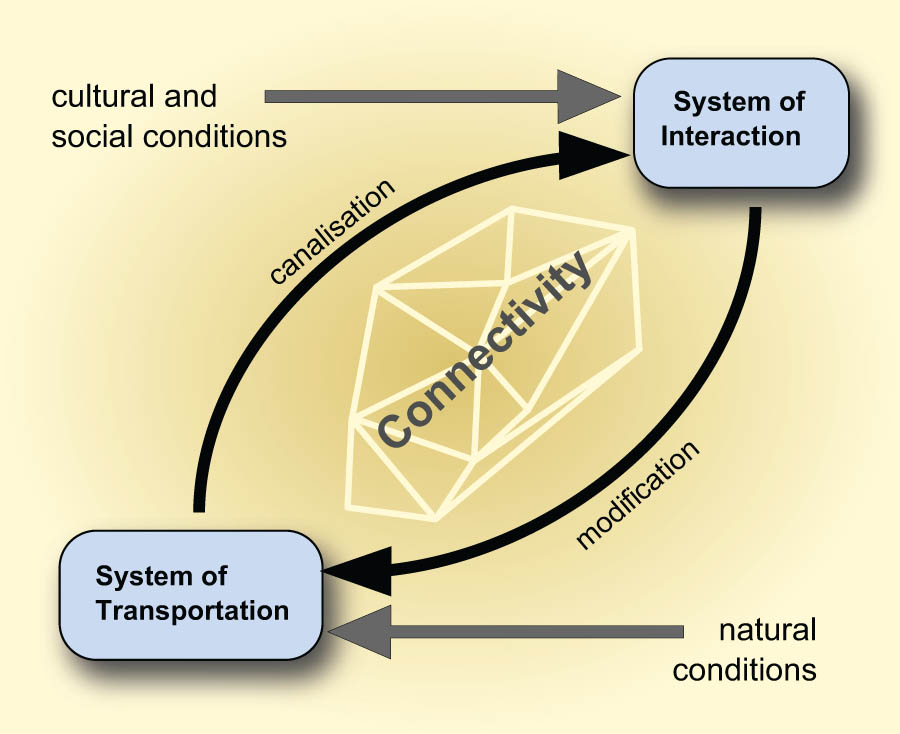
Interrelationship of the transport system and the interaction system.
6 Conclusion
Transport is a broad field of research and includes many aspects of which this article just touched a small part. Putting transport into context by addressing interaction and connectivity demonstrates that transport research is much more than a technical topic but contributes deep insights into societies. The transport system and the interaction system appear to be complementary, while connectivity contributes a specific perspective by focussing on the relevant drivers of system dynamics. For both sub-systems, different approaches complement each other. These approaches include different scales dealing with detailed or general patterns and different kinds of patterns based on networks, grouping approaches, and degrees of a certain effect. The concept of connectivity adds a layer of complexity that develops our understanding of the dynamics of the transport-interaction system. The different approaches address different questions, providing a multi-faceted picture of ancient exchange and transport through the integration of multidisciplinary approaches (Figure 5).

Conceptual scheme of Transport-Interaction-Connectivity research.
-
Funding information: This research was funded by the Deutsche Forschungsgemeinschaft (DFG, German Research Foundation) under Germany´s Excellence Strategy – EXC 2150 – 390870439 and Projektnummer 2901391021-SFB 1266.
-
Conflict of interest: Author states no conflict of interest.
-
Data availability statement: Data sharing is not applicable to this article as no datasets were generated or analysed during the current study.
References
Albu, E. (2014). The medieval Peutinger map: Imperial Roman revival in a German empire. Cambridge: Cambridge University Press.10.1017/CBO9781107444997Search in Google Scholar
Aleskerov, F., Shvydun, S., & Meshcheryakova, N. (2021). New centrality measures in networks. Boca Raton: Chapman & Hall/CRC. doi: 10.1201/9781003203421-1.Search in Google Scholar
Alexeev, A. I. (2001). Nomades des steppes: Les scythes, viie - iiie siècle av. J.-C. In L. L. Barkova & L. K. Galanina, (Eds.). Paris: Autrement.Search in Google Scholar
Argyle, M. (1969). Social interaction. London: Methuen.Search in Google Scholar
Baddeley, A., Rubak, E., & Turner, R. (2016). Spatial point patterns: Methodology and applications with r. Boca Raton: CRC Press, Taylor & Francis Group.10.1201/b19708Search in Google Scholar
Becker, T. (1880). Ueber Römerstrassen in Baden und Wirtemberg. Jahrbücher des Vereins von Alterthumsfreunden im Rheinlande, 67, 11–13.Search in Google Scholar
Bliujienė, A. (Ed.). (2009). The horse and man in European antiquity (worldview, burial rites and military and everyday life). Klaipėda: University Press.Search in Google Scholar
Blöck, L. (2014). Die Siedlungs- und Verkehrstopographie an Hoch- und Oberrhein am Übergang zur Spätantike. In Antike im Mittelalter (pp. 249–285). Ostfildern: Thorbecke.Search in Google Scholar
Chaume, B., Cheetham, P., Komp, R., Lüth, F., & Weißl, M. (2020). Vix et l’émergence des principautés celtiques: L’hypothèse portuaire et le concept de port of trade. Gallia, 77(1), 435–452.10.4000/gallia.5394Search in Google Scholar
Crumlin-Pedersen, O. (1997). Viking-age ships and shipbuilding in Hedeby/Haithabu and Schleswig. Schleswig: Archäolog. Landesmuseum der Christian-Albrechts-Univ. [u.a.].Search in Google Scholar
Davies, H. E. H. (2002). Roads in Roman Britain. Stroud [u.a.]: Tempus Publication.Search in Google Scholar
Endlich, C., & Lässig, H.-C. (2007). Holzverbrauch in großen Mengen: Moorwege der frühesten Bauform. In M. Fansa & D. Vorlauf (Eds.), Holz-Kultur von der Urzeit bis in die Zukunft. Ökologie und Ökonomie eines Naturrohstoffs im Spiegel der Experimentellen Archäologie, Ethnologie, Technikgeschichte und modernen Holzforschung (pp. 143–147). Oldenburg: Isensee.Search in Google Scholar
Englert, A. (2015). Large cargo ships in Danish waters 1000–1250: Evidence of specialised merchant seafaring prior to the Hanseatic period. In A. Englert & O. Crumlin-Pedersen, (Eds.). Roskilde: Viking Ship Museum.10.2307/j.ctvh1dsn7.46Search in Google Scholar
Faupel, F. (2021). Modelling spatial interaction during the early iron age: Reconstructing and modelling ancient infrastructure, interaction and distribution systems in southwest germany and the alsace. (PhD thesis). Christian-Albrechts-Universität zu Kiel, Kiel. https://macau.uni-kiel.de/receive/macau_mods_00001330.Search in Google Scholar
Faupel, F., & Nakoinz, O. (2018). Rekonstruktion des Wegesystems und Identifikation von Wegparametern der Bronzezeit in Schleswig-Holstein. In B. Nessel, D. Neumann, & M. Bartelheim (Eds.), Bronzezeitlicher Transport – Akteure, Mittel und Wege (pp. 249–268). Tübingen: Tübingen University Press.Search in Google Scholar
Fetter, F. A. (1924). The economic law of market areas. The Quarterly Journal of Economics, 38(3), 520–529.10.2307/1882335Search in Google Scholar
Feugnet, A., Rossi, F., & Filet, C. (2017). Co-presence analysis and economic patterns: Mediterranean imports in the Celtic world. Frontiers in Digital Humanities. 4, doi: 10.3389/fdigh.2017.00001.Search in Google Scholar
Filet, C. (2017). An attempt to estimate the impact of the spread of economic flows on latenian urbanization1. Frontiers in Digital Humanities, 3. doi: 10.3389/fdigh.2016.00010.Search in Google Scholar
Fliedner, S., & Pohl-Weber, R. (1972). The Cog of Bremen (3rd ed.). Bremen: Förderverein “Bremer Hanse-Kogge”.Search in Google Scholar
Freeman, L. C. (1978). Centrality in social networks conceptual clarification. Social Networks, 1(3), 215–239. London: Routledge. doi: 10.1016/0378-8733(78)90021-7.Search in Google Scholar
Fulminante, F. (2020). Terrestrial communication networks and political agency in early iron age central italy (950–500 BCE). London: Routledge. doi: 10.4324/9781351003063-9.Search in Google Scholar
Furger-Günti, A. (1991). The celtic war chariot. The experimental reconstruction in the Schweizerisches Landesmuseum. In C. Tanzi & M. Andreose, (Eds.). Bompiani: Milano.Search in Google Scholar
Habiba, Athenstädt, J., Mills, B., & Brandes, U. (2018). Social networks and similarity of site assemblages. doi: 10.1016/J.JAS.2017.11.002.Search in Google Scholar
Harbison, P. (1969). The chariot of celtic funerary tradition. Marburger Beiträge Zur Archäologie Der Kelten, 34–58.Search in Google Scholar
Hayen, H. (1958). Zur Bautechnik und Typologie der vorgeschichtlichen, frühgeschichtlichen und mittelalterlichen hölzernen Moorwege und Moorstraßen. Oldenburger Jahrbücher, 56(2), 83–170.Search in Google Scholar
Helbing, D., Keltsch, J., & Molnár, P. (1997). Modelling the evolution of human trail systems. Nature, 388, 47–50.10.1038/40353Search in Google Scholar
Herzog, I. (2016). Mit Mercator-Karte und Lidar-Daten auf der Suche nach Altwegen im Bergischen Land. Archäologie im Rheinland, 46–49.Search in Google Scholar
Heumüller, M. (2018). Moorwege in Niedersachsen: Erfassung, Erforschung und Erhaltung – eine arbeitsintensive Daueraufgabe der Denkmalpflege. Berichte zur Denkmalpflege in Niedersachsen, 3, 113–115.Search in Google Scholar
Hinz, H. (1951). Hinz 1950/1951: H. Hinz, Hügelgrabwege an der Westküste Schleswigs. Archaeologica Geographica, 1, 52–53.Search in Google Scholar
Hirte, C. (1987). Zur Archäologie monoxyler Wasserfahrzeuge im nördlichen Mitteleuropa: Eine Studie zur Repräsentativität der Quellen in chorologischer, chronologischer und konzeptioneller Hinsicht. (PhD thesis). Christian-Albrechts-Universität zu Kiel, Kiel.Search in Google Scholar
Homans, G. C. (1950). The human group. In B. DeVoto, (Ed.). New York: Harcourt, Brace.Search in Google Scholar
Jacob-Friesen, K. H. (1928). Grundfragen der Urgeschichtsforschung: Stand und Kritik der Forschung über Rassen, Völker und Kulturen in urgeschichtlicher Zeit. Hannover: Helwing.Search in Google Scholar
Johnstone, P. (2013). The sea-craft of prehistory. Hoboken: Taylor; Francis.10.4324/9781315800332Search in Google Scholar
Kahanov, Y., & Pomey, P. (2004). The Greek sewn shipbuilding tradition and the Ma’agan Mikhael ship: A comparison with Mediterranean parallels from the sixth to the fourth centuries BC. The Mariner’s Mirror, 1, 6–28.10.1080/00253359.2004.10656882Search in Google Scholar
Kaiser, E. (2010). Wurde das Rad zweimal erfunden?: Zu den frühen Wagen in der eurasischen Steppe. Prähistorische Zeitschrift, 2, 137–158.10.1515/pz.2010.009Search in Google Scholar
Katajainen, J., & Nevalainen, O. (1986). Computing relative neighbourhood graphs in the plane. Pattern Recognition, 19(3), 221–228. doi: 10.1016/0031-3203(86)90012-9.Search in Google Scholar
Kaul, F. (1998). Ships on bronzes: A study in Bronze age religion and iconography. Copenhagen: National Museum of Denmark.Search in Google Scholar
Klassen, L. (2014). Along the road: Aspects of causewayed enclosures in south Scandinavia and beyond. Aarhus: Aarhus University Press.10.2307/jj.608320Search in Google Scholar
Knappett, C. (Ed.). (2013). Network analysis in archaeology: New approaches to regional interaction (1st ed.). Oxford: Oxford University Press.10.1093/acprof:oso/9780199697090.001.0001Search in Google Scholar
Koch, J. K. (1999). Der Wagen und das Pferdegeschirr aus dem späthallstattzeitlichen Fürstengrab von Eberdingen-Hochdorf (Kr. Ludwigsburg). (PhD thesis). Christian-Albrechts-Universität zu Kiel, Kiel.Search in Google Scholar
Koschützki, D., Lehmann, K. A., Peeters, L., Richter, S., Tenfelde-Podehl, D., & Zlotowski, O. (2005). Chapter 3. Centrality indices. In Network analysis. Methodological foundations (pp. 16–61). Berlin: Springer. doi: 10.1007/b106453.Search in Google Scholar
Lehnemann, E., Urz, R., & Meiborg, C. (2021). Die latènezeitliche Brücke mit Siedlung bei Kirchhain-Niederwald, Landkreis Marburg-Biedenkopf. Interdisziplinäre Forschungen zur eisenzeitlichen Siedlungslandschaft des Amöneburger Beckens. Mit Beiträgen von Lisa Bringemeier, Anita Goldner-Bofinger, Jutta Hofmann, Marlu Kühn, Karlheinz Steppan, Astrid Stobbe, Thorsten Westphal, Lucia Wick.Search in Google Scholar
Leidwanger, J., & Knappett, C., (Eds.). (2018). Maritime networks in the ancient Mediterranean world: Workshop. Networks of maritime connectivity in the ancient Mediterranean: Structure, continuity, and change over the longue durée. Cambridge: Cambridge University Press.10.1017/9781108555685Search in Google Scholar
Lewis, J. (2021). Probabilistic modelling for incorporating uncertainty in least cost path results: A postdictive Roman road case study. Journal of Archaeological Method and Theory, 28, 911–924. doi: 10.1007/S10816-021-09522-W.Search in Google Scholar
Margary, I. D. (1973). Roman roads in Britain (3rd ed.). London: Baker.Search in Google Scholar
Marschalleck, K.-H. (1964). Zum Problem der ur- und frühgeschichtlichen Wege in Nordwestdeutschland. Beispiele aus dem Nordseeküstenraum. In P. Grimm (Ed.), Varia archaeologica. Festschrift w. Unverzagt (pp. 410–426). Berlin: Deutsche Akademie des Wissens zu Berlin.Search in Google Scholar
Martens, J. (2010). A magnate’s farm at Borremose? In Gedächtnis-kolloquium werner haarnagel (1907–1984) (pp. 181–195). Rahden/Westf: Leidorf.Search in Google Scholar
McGrail, S. (1978). Logboats of England and Wales with comparative material from European and other countries. Oxford: BAR.Search in Google Scholar
Metzler, J. (1995). Das treverische Oppidum auf dem Titelberg: (G.-H. Luxemburg); zur Kontinuität zwischen der spätkeltischen und der frührömischen Zeit in Nord-Gallien. Luxembourg: Musée National d’Histoire et d’Art.Search in Google Scholar
Millot-Richard, C. (2021). Iron semi-finished products as a currency and Celtic coins. Études Celtiques, 46, 125–135.Search in Google Scholar
Müller, S. (1904). Müller 1904: S. Müller, Vej og Bygd i Sten- og Bronzealderen. Aarbøger, 1–64.Search in Google Scholar
Nakoinz, O. (2005). Wrack 4 von Haithabu Ein Prahm des 12. Jahrhunderts und seine Parallelen im Ostseeraum. Archäologisches Korrespondenzblatt, 35, 123–142.Search in Google Scholar
Nakoinz, O. (2009). Zentralortforschung und zentralörtliche Theorie. Archäologisches Korrespondenzblatt, 39, 361–380.Search in Google Scholar
Nakoinz, O. (2012). Ausgewählte Parameter der Lage von Wegen und Monumenten als Proxy für soziale Prozesse prähistorischer Gesellschaften. In M. Hinz & J. Müller (Eds.), Siedlung, Grabenwerk, Großsteingrab. Studien zu Gesellschaft, Wirtschaft und Umwelt der Trichterbechergruppen im nördlichen Mitteleuropa (pp. 445–456). Bonn: Habelt.Search in Google Scholar
Nakoinz, O. (2013a). Archäologische Kulturgeographie der ältereisenzeitlichen Zentralorte Südwestdeutschlands. Bonn: Habelt.Search in Google Scholar
Nakoinz, O. (2013b). Models of interaction and economical archaeology. Metalla, 20(2), 107–115.Search in Google Scholar
Nakoinz, O. (2013c). Räumliche Interaktionsmodelle. Praehistorische Zeitschrift, 88, 226–257.10.1515/pz-2013-0008Search in Google Scholar
Nakoinz, O. (2014). Fingerprinting Iron Age communities in South-West Germany and an integrative theory of culture. In C. Popa & S. Stoddart (Eds.), Fingerprintig the Iron Age (pp. 187–199). Oxford: Oxbow.10.2307/j.ctvh1dv7b.21Search in Google Scholar
Nakoinz, O. (2017). Quantifying Iron Age urbanism. In S. Stoddart (Ed.), Delicate urbanism in context: Pre-Roman German urbanism (The DAAD Cambridge Symposium) (pp. 87–95). Cambridge: McDonald Institute.Search in Google Scholar
Nakoinz, O., & Knitter, D. (2016). Modelling human behaviour in landscapes – Basic concepts and modelling elements. New York: Springer.10.1007/978-3-319-29538-1Search in Google Scholar
Nakoinz, O., Knitter, D., Faupel, F., & Nykamp, M. (2020). Modelling interaction in landscapes. In P. Łuczkiewicz (Ed.), Landschaft und Siedlungen. Archäologische Studien zur vorrömischen Eisenzeit- und älteren Kaiserzeit in Mittel- und Südost Europa (pp. 12–45). Lublin: Wydawnictwo UMCS.Search in Google Scholar
Nakoinz, O., Rinne, C., Loy, A. K., Kneisel, J., Taylor, N., Schreiber, T., & Wunderlich, M. (2022). Connectivity and fortifications. In J. Müller (Ed.), Social, cultural, environmental connectivities in past societies. Leiden: Sidestone.Search in Google Scholar
Okabe, A. (2000). Spatial tessallations: Concepts and applications of Voronoi diagrams (2nd ed.). In B. Boots, K. Sugihara, S. N. Chiu, & D. G. Kendall, (Eds.). Chichester: John Wiley & Sons.10.1002/9780470317013Search in Google Scholar
Österborn, P., & Gerding, H. (2015). The diffusion of fired bricks in Hellenistic Europe: A similarity network analysis. Journal of Archaeological Method and Theory, 22, 306–344. doi: 10.1007/S10816-014-9229-4.Search in Google Scholar
Pare, C. F. E. (1988). Ceremonial wagons and wagon-graves of the early Iron Age in Central Europe. (PhD thesis). University of Oxford, Oxford.Search in Google Scholar
Pare, C. F. E. (1991). Swords, wagon-graves, and the beginning of the early Iron Age in Central Europe. Marburg: Vorgeschichtliches Seminar.Search in Google Scholar
Pitz, E. (1962). Archivalische quellen zur wegeforschung. Berlin: Lukas-Verl.Search in Google Scholar
Rathmann, M. (2003). Untersuchungen zu den Reichsstraßen in den westlichen Provinzen des Imperium Romanum. Mainz: von Zabern.Search in Google Scholar
Renfrew, C. (1973). Before civilization: The radiocarbon revolution and prehistoric Europe. London: Cape.Search in Google Scholar
Renfrew, C. (1975). Trade as action at a distance: Questions of integration and communication. In J. A. Sabloff & C. C. Lamberg-Karlovsky (Eds.), Ancient civilization and trade (pp. 3–60). Albuquerque: University of New Mexico Press; University of New Mexico Press.Search in Google Scholar
Renfrew, C. (1977). Alternative models for exchange and spatial distribution. In T. K. Earl & J. E. Ericson (Eds.), Exchange systems in prehistory (pp. 71–90). San Diego: Academic Press. doi: 10.1016/B978-0-12-227650-7.50010-9.Search in Google Scholar
Renfrew, C., & Level, E. V. (1979). Exploring dominance: Predicting polities from centers. In C. Renfrew & K. L. Cooke (Eds.), Transformations (pp. 145–167). Cambridge: Academic Press. doi: 10.1016/B978-0-12-586050-5.50016-6.Search in Google Scholar
Rieck, F. (1994). Jernalderens skibe: Nye og gamle udgravninger i nydam mose. Roskilde: Vikingeskibshallen.Search in Google Scholar
Ripley, B. D. (1981). Spatial statistics. New York [u.a.]: Wiley.10.1002/0471725218Search in Google Scholar
Rosenberg, G. A. (1937). Hjortspringfundet. In K. Jessen & F. Johannessen, (Eds.). København: Gyldendalske boghandel, Nordisk forl.Search in Google Scholar
Schneider, J. (1848). Römerstraßen in der umgebung von trier. Jahrbücher Des Vereins von Alterthumsfreunden Im Rheinlande, 13, 23–25.Search in Google Scholar
Sindbæk, S. M. (2007). The small world of the Vikings: Networks in Early Medieval communication and exchange. Norwegian Archaeological Review, 1, 59–74.10.1080/00293650701327619Search in Google Scholar
Stoddart, S. (2020). Power and place in Etruria: The spatial dynamics of a Mediterranean civilization, 1200–500 BC. Cambridge: Cambridge University Press.10.1017/9781139043687Search in Google Scholar
Tavassoli, S. (2018). Analyzing centrality indices in complex networks: An approach using fuzzy aggregation operators. Kaiserslautern: Technische Universität Kaiserslautern.Search in Google Scholar
Tilburg, C. (2007). Traffic and congestion in the Roman Empire (1st ed.). London: Routledge.10.4324/9780203968031Search in Google Scholar
Veldmeijer, A. J. (2017). Chariots in ancient Egypt. The Tano Chariot. A case study. Leiden: Sidestone Press.Search in Google Scholar
Vermeulen, F., & Antrop, M. (Eds.). (2001). Ancient lines in the landscape: A geo-archaeological study of protohistoric and Roman roads and field systems in Northwestern Gaul. Leuven: Peeters.Search in Google Scholar
Voronoi, G. (1907). Nouvelles applications des paramètres continus àă la théorie des formesquadratique. Journal Für Die Reine Und Angewandte Mathematik, 133, 97–178. doi: 10.1515/crll.1908.133.97.Search in Google Scholar
Vött, A., Fischer, P., & Hadler, H. (2015). Detection of two different harbour generations at ancient Ostia (Italy) by means of geophysical and stratigraphical methods. In S. Ludwig, M. Heinzelmann, C. Rohn, T. Wunderlich, D. Wilken, E. Erkul, & W. Rabbel (Eds.), Häfen im 1. Millennium AD (pp. 23–34). Regensburg: Schnell & Steiner.Search in Google Scholar
Westerdahl, C. (1986). Die maritime Kulturlandschaft: Schiffe, Schiffahrtswege, Häfen; Überlegungen zu einem Forschungsansatz. Deutsches Schiffahrtsarchiv, 7–58.Search in Google Scholar
Westerdahl, C. (1998). Inland water boats and shipping in sweden. The great lakes [the application of a theory on transport zones and maritime enclaves]. Archaeonautica, 14, 135–143. doi: 10.3406/NAUTI.1998.1195.Search in Google Scholar
Westerdahl, C. (2006). The relationship between land roads and sea routes in the past: Some reflections. Deutsches Schiffahrtsarchiv, 59–114.Search in Google Scholar
© 2023 the author(s), published by De Gruyter
This work is licensed under the Creative Commons Attribution 4.0 International License.
Articles in the same Issue
- Regular Articles
- A 2D Geometric Morphometric Assessment of Chrono-Cultural Trends in Osseous Barbed Points of the European Final Palaeolithic and Early Mesolithic
- Wealth Consumption, Sociopolitical Organization, and Change: A Perspective from Burial Analysis on the Middle Bronze Age in the Carpathian Basin
- Everything Has a Role to Play: Reconstruction of Vessel Function From Early Copper Age Graves in the Upper Tisza Region (Eastern Hungary)
- Urban Success and Urban Adaptation Over the Long Run
- Exploring Hypotheses on Early Holocene Caspian Seafaring Through Personal Ornaments: A Study of Changing Styles and Symbols in Western Central Asia
- Victims of Heritage Crimes: Aspects of Legal and Socio-Economic Justice
- On the (Non-)Scalability of Target Media for Evaluating the Performance of Ancient Projectile Weapons
- Small Houses of the Dead: A Model of Collective Funerary Activity in the Chalcolithic Tombs of Southwestern Iberia. La Orden-Seminario Site (Huelva, Spain)
- Bigger Fish to Fry: Evidence (or Lack of) for Fish Consumption in Ancient Syracuse (Sicily)
- Terminal Ballistics of Stone-Tipped Atlatl Darts and Arrows: Results From Exploratory Naturalistic Experiments
- First Archaeological Record of the Torture and Mutilation of Indigenous Mapuche During the “War of Arauco,” Sixteenth Century
- The Story of the Architectural Documentation of Hagia Sophia’s Hypogeum
- Iconographic Trends in Roman Imperial Coinage in the Context of Societal Changes in the Second and Third Centuries CE: A Small-Scale Test of the Affluence Hypothesis
- Circular Economy in the Roman Period and the Early Middle Ages – Methods of Analysis for a Future Agenda
- New Insights Into the Water Management System at Tetzcotzinco, Mexico
- How Linguistic Data Can Inform Archaeological Investigations: An Australian Pilot Study Around Combustion Features
- Leadership in the Emergent Baekje State: State Formation in Central-Western Korea (ca. 200–400 CE)
- Middle Bronze Age Settlement in Czeladź Wielka – The Next Step Toward Determining the Habitation Model, Chronology, and Pottery of the Silesian-Greater Poland Tumulus Culture
- On Class and Elitism in Archaeology
- Archaeology of the Late Local Landscapes of the Hualfín Valley (Catamarca, Argentina): A Political Perspective from Cerro Colorado of La Ciénaga de Abajo
- Review Article
- The State of the Debate: Nuragic Metal Trade in the Bronze Age and Early Iron Age
- A Review of Malta’s Pre-Temple Neolithic Pottery Wares
- Commentary Article
- Paradise Found or Common Sense Lost? Göbekli Tepe’s Last Decade as a Pre-Farming Cult Centre
- Special Issue Published in Cooperation with Meso’2020 – Tenth International Conference on the Mesolithic in Europe, edited by Thomas Perrin, Benjamin Marquebielle, Sylvie Philibert, and Nicolas Valdeyron - Part II
- The Time of the Last Hunters: Chronocultural Aspects of Early Holocene Societies in the Western Mediterranean
- Fishing Nets and String at the Final Mesolithic and Early Neolithic Site of Zamostje 2, Sergiev Posad (Russia)
- Investigating the Early-to-Late Mesolithic Transition in Northeastern Italy: A Multifaceted Regional Perspective
- Socioeconomic, Technological, and Cultural Adaptation of the Mesolithic Population in Central-Eastern Cantabria (Spain) in the Early and Middle Holocene
- From Coastal Sites to Elevated Hinterland Locations in the Mesolithic – Discussing Human–Woodland Interaction in the Oslo Fjord Region, Southeast Norway
- Exploitation of Osseous Materials During the Mesolithic in the Iron Gates
- Motorways of Prehistory? Boats, Rivers and Moving in Mesolithic Ireland
- Environment and Plant Use at La Tourasse (South-West France) at the Late Glacial–Holocene Transition
- Stylistic Study of the Late Mesolithic Industries in Western France: Combined Principal Coordinate Analysis and Use-Wear Analysis
- Mesolithic Occupations During the Boreal Climatic Fluctuations at La Baume de Monthiver (Var, France)
- Pressure Flakers of Late Neolithic Forest Hunter-Gatherer-Fishers of Eastern Europe and Their Remote Counterparts
- The Site Groß Fredenwalde, NE-Germany, and the Early Cemeteries of Northern Europe
- Special Issue on Archaeology of Migration: Moving Beyond Historical Paradigms, edited by Catharine Judson & Hagit Nol
- The Blurry Third Millennium. “Neolithisation” in a Norwegian Context
- Movement or Diaspora? Understanding a Multigenerational Puebloan and Ndee Community on the Central Great Plains
- Human Mobility and the Spread of Innovations – Case Studies from Neolithic Central and Southeast Europe
- The Thule Migration: A Culture in a Hurry?
- The Transformation of Domes in Medieval Chinese Mosques: From Immigrant Muslims to Local Followers
- Landscapes of Movement Along the (Pre)Historical Libyan Sea: Keys for a Socio-Ecological History
- Arab Migration During Early Islam: The Seventh to Eighth Century AD from an Archaeological Perspective
- Special Issue on Ancient Cultural Routes: Past Transportations Infrastructures as a Two-Way Interaction Between Society and Environment, edited by Francesca Fulminante, Francesca Mazzilli & Franziska Engelbogen
- The Impact of Transportation on Pottery Industries in Roman Britain
- The Role of the Road in Settling a Mountainous Region
- An Example of Geographic Network Analysis: The Case Study of the Fortore Valley (Molise and Apulia, Italy)
- Water, Communication, Sight, and the Location of Fortifications on the Strata Diocletiana (Syria) in Late Antiquity
- Transport, Interaction, and Connectivity
- Special Issue on Scales of Interaction in the Bronze and Iron Age Central Mediterranean, edited by Emily Holt & Davide Schirru
- Tracing Mobility Patterns of Buried Species of the Late Iron Age Funerary Staggered Turriform of Son Ferrer (Calvià, Spain)
- Approaching Interaction in Iron Age Sardinia: Multi-Scalar Survey Evidence from the Sinis Archaeological Project and the Progetto S’Urachi
- From the Atlantic to the Mediterranean and Back: Sardinia, Iberia, and the Transfer of Knowledge in Late Bronze Age Networks
- Special Issue on Bricks Under the Scope: Microscopic and Macroscopic Approaches to the Study of Earthen Architecture, edited by Marta Lorenzon, Moritz Kinzel, & Benjamín Cutillas-Victoria
- Earthen Architecture in Nordic Countries: Future Directions
- Earthen Architecture and Craft Practices of Early Iron Age Ramparts: Geoarchaeological Analysis of Villares de la Encarnación, South-Eastern Iberia
- Earthen Architecture in Southern Algeria: An Assessment of Social Values and the Impact of Industrial Building Practices
- Studying the Use of Earth in Early Architecture of Southwest and Central Asia
- Roof Tiles and Bricks of the Etruscan Domus dei Dolia (Vetulonia, Italy): An Archaeological and Archaeometric Study of Construction Materials
- The Building Blocks of Circular Economies: Rethinking Prehistoric Turf Architecture Through Archaeological and Architectural Analysis
- Undecorated Roman-Period Roof Tiles – An Old Material Providing New Results
- Turf Building in Iceland – Past, Present, and Future
- Special Issue on Past Sounds: New Perspectives in the Field of Archaeoacoustics, edited by Margarita Díaz-Andreu & Neemias Santos da Rosa
- Employing Psychoacoustics in Sensory Archaeology: Developments at the Ancient Sanctuary of Zeus on Mount Lykaion
- One, Two, Three! Can Everybody Hear Me? Acoustics of Roman Contiones. Case Studies of the Capitoline Hill and the Temple of Bellona in Rome
- Ringing Tone and Drumming Sages in the Crevice Cave of Pirunkirkko, Koli, Finland
- Music and Storytelling at Rock Art Sites? The Archaeoacoustics of the Urkosh Area (Russian Altai)
- Listening in Sacred Spaces: The Sanctuary of Poseidonia and Selinunte’s Main Urban Sanctuary
- Presenting Archaeoacoustics Results Using Multimedia and VR Technologies
- Special Issue on Reconsidering the Chaîne Opératoire: Towards a Multifaceted Approach to the Archaeology of Techniques, edited by Marie-Elise Porqueddu, Claudia Sciuto & Anaïs Lamesa
- Reconsidering the Chaîne Opératoire: At the Crossroad Between People and Materials
- Materiality of Plaster Vessels: The Problem of Southwest Asian Neolithic White Ware
- The Chaîne Opératoire Approach for Interpreting Personal Ornament Production: Marble Beads in Copper Age Tuscany (Italy)
- Seriality and Individualization: Carving the Fluted Sarcophagi from Hierapolis of Phrygia
- Making Vessels for the Dead: Pottery-Making Practices, Chaîne Opératoire and the Use of Grog (Crushed Sherds) as a Technological and Cultural Choice during Late and Inca Periods in the Northwestern Argentine Region (Southern Andes)
- An Invention Shading Light to the Socio-History of Bonneuil Quarry Basin: The Roadheaders with Rotating Drill Bits
- The Ugly Duckling: Understanding the Making of an Early Copper Age Atypical Ceramic Vessel from the Great Hungarian Plain
- Synopsis of a Treasure. A Transdisciplinary Study of Medieval Gold Workings Biographies
- Identification of Ceramic Traditions on the Prehistoric Mines of Gavà (Barcelona, Spain)