Reconciling Contradictory Archaeological Survey Data: A Case Study from Central Crete, Greece
-
Quentin Drillat


Abstract
Rescue archaeology in urban contexts often opens small windows on ancient settlements that need to be combined to better perceive the history of these settlements. This article suggests that the same combinatory approach should be employed with survey data. Indeed, archaeological surveys can split single ancient settlements into multiple archaeological sites due to visibility changes. It implies that the perception we have of legacy datasets must change: errors in location data might occur in older, and especially pre-GPS, survey datasets, but the fact that more recent projects have not been able to find sites on the exact same spots might also be related to changes in visibility windows. Using a case study from central Crete, Greece, where two survey projects were conducted in the same area, this article suggests that the variability in location data of sites recorded during survey projects can provide new insights into settlement patterns and dynamics. Notably, evidence of grouped settlements is found, including for periods such as Late Minoan II and Late Minoan III C, previously known for a strong decrease in large settlements’ occupation.
1 Introduction
Archaeological surveys are an essential tool to explore ancient settlement dynamics at a regional scale (Attema et al., 2020; Banning, 2002; Knodell et al., 2023). However, it has been suggested that they can split single ancient settlements into multiple archaeological sites, recorded at different locations, and with different occupation phases, leading to an incorrect understanding of settlement patterns in surveyed regions (Gaignerot-Driessen, 2016, p. 30). This over-splitting is an effect of visibility changes across space: high visibility windows are very localized, especially in areas where land use is heterogeneous. Vegetation, or other visibility parameters, can hide parts of an ancient settlement, and therefore artificially split it into multiple parts visible during surveys. The very same effect is well known in urban contexts, where rescue excavations open (very) small windows on ancient settlements, where modern works allow us to open trenches. The multiplication of these highly localized observations and their combination contribute to a better understanding of the settlements’ history (Wech, 2021; Whitelaw, 2013). This article applies the same combinatory approach to survey data, considering archaeological sites as windows on ancient settlements. Data on several archaeological sites can be combined and provide information on single settlements. By combining data from multiple sites, settlement extensions and chronologies can be reassessed. This approach enables us to correct the over-splitting observed in survey results and to produce more information on ancient settlements. The aim is therefore to provide a new tool for future works on combining survey datasets, an approach now commonly used to work at a regional scale (Attema et al., 2021; Cloke & Athanassopoulos, 2020; Kearns, 2022).
Because land use, vegetation and other post-depositional processes can considerably change the visibility from one archaeological survey campaign to another (Ammerman et al., 2013; Casarotto et al., 2018, 2021; Terrenato & Ammerman, 1996; Thompson, 2004), ancient rural sites are said to appear and disappear like “traffic lights” in the contemporary landscape in the case of areas where multiple surveys have been conducted (Attema et al., 2020; Casarotto et al., 2021; García Sánchez et al., 2017; Lloyd & Barker, 1981). Within the extent of an ancient settlement, the same “traffic light” effect can also occur: portions of the settlement can be visible during a survey and others may appear during a re-survey. The results of some intra-site urban surveys have even suggested that the opening of new windows can happen from 1 year to another, with many new artifacts appearing on the ground (van den Eijnde et al., 2021). These new windows can explain the variability of the results of successive surveys, both spatially and chronologically (Ammerman et al., 2013). Consequently, survey results are not replicable by nature, and re-surveys (i.e. multiple surveys of the same area) produce notably different datasets that offer complementary information on ancient settlements. There might be an inclination to exclude older datasets from modern landscape archaeology studies based on spatial analysis, but legacy data should not be totally replaced by more recent results (Bonnier et al., 2019; Ullah, 2015; Witcher, 2008), particularly when considering the potential damages that may have occurred on many sites since their initial documentation.
As a case study, two survey projects in central Crete, the Pediada survey (Panagiotakis, 2003) and the Galatas survey (Watrous et al., 2017), focusing on the surroundings of the Minoan site of Galatas, are considered. These surveys were conducted 20 years apart and produced very different results. Nevertheless, this article supports the validity of the results of both surveys, meaning that both projects actually recorded archaeological sites at the location of ancient settlements (Wandsnider & Camilli, 1992). It also suggests that some survey sites from both surveys can be considered as multiple parts of the same ancient settlements. The combination of the data available on multiple sites corresponding to the same settlements enables us to update interpretations of settlement dynamics, both at a settlement scale and at a regional scale. Hence, the variability of resurvey results appears to be an opportunity to get more information on ancient settlement patterns. In the case study presented in this article, this approach provides new information on (previously undetected) large settlements that update our knowledge of spatial organization dynamics in the region.
2 Case Study: The Pediada and Galatas Survey Datasets
As a case study, this article uses the results of two overlapping extensive survey projects, the Pediada survey (Panagiotakis, 2003) and the Galatas survey (Watrous et al., 2017), with the study area of the latter being fully contained within the former. Both surveys studied the ancient occupation of a low-relief area in north-central Crete (Figure 1), which is nowadays mostly devoted to agriculture. Ancient settlements in the region include the Bronze Age palatial building and town at Galatas (Rethemiotakis, 2017), and the later city at Astritsi, located between the two powerful and rival city-states of Knossos and Lyktos, in north-central Crete. Both the Pediada and Galatas survey projects aimed to discover and record ancient sites, defined as concentrations of artifacts (mostly sherds, or architectural remains) from the Neolithic to the Venetian period. The Pediada survey especially focused on the evolution of land-use and settlement patterns in the Pediada area, while the Galatas survey project focused more on the direct human environment of the palatial site of Galatas. However, as suggested by their very different extents (Figure 1), they employed very different methodologies to discover and record archaeological sites (Table 1).
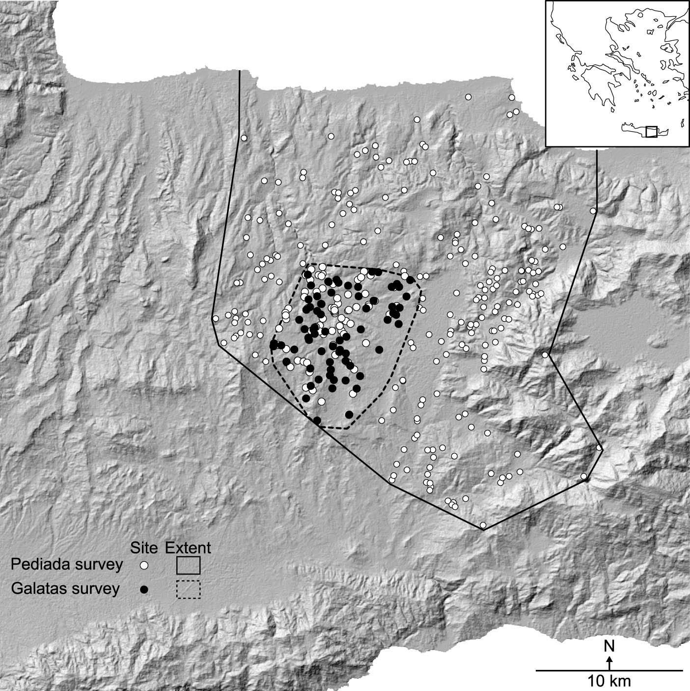
Study area and sites under consideration.
Survey project comparison
| Survey project | Pediada | Galatas |
|---|---|---|
| Administrative data | Directed by Nikos Panagiotakis Conducted in the 1980s | Directed by Livingston Vance Watrous Conducted in 2005–2007 |
| Methodology | Extensive, interview-based survey | Intensive/extensive survey |
| Extent | 800 km² | 79 km² |
| Settlement classification | 2 categories: settlements and large settlements | 4 categories based on site size: farmsteads, hamlets, villages, towns |
| Site size evolution | No data | Site size assessed for each occupation period |
| Publication state | Partial (2003) | Final (2017) |
The Pediada survey project was conducted in the 1980s over an area of about 800 km² and directed by Nikos Panagiotakis. Because he worked alone, he decided to base his survey on interviews with local informants, asking them to show him places where they knew there were ancient walls or sherds (Panagiotakis, 2003). This interview-based approach, common in the 1960s, proved to be successful in other contexts (Naylor, 1981; Schiffer et al., 1978). In the context of central Crete, it enabled Nikos Panagiotakis to record a great many unknown sites. Site locations were reported on a map, and efforts were made to ascertain the site’s extent and sherd density through systematic walking in circular or linear patterns (Panagiotakis, 2003). The most detailed publication of this survey to date provides a list of sites, their geographical coordinates and periods of occupation, and a brief description of the sites’ function (mostly “settlement” or “large settlement,” with no clear indication of the limit between a small and a large settlement) and environmental context (Panagiotakis, 2003). This publication has been supplemented by some complementary studies of specific periods (Panagiotakis, 2004 on Proto- and Neopalatial periods; Panagiotakis et al., 2011 on Middle and Late Minoan periods; Paschalidis et al., 2017 on LM IIIB; Stefanakis, 2011 on the Archaic period).
On the other hand, the Galatas survey project was conducted between 2005 and 2007 under the direction of L. Vance Watrous. It focused on a 79 km² area and used a more traditional methodology of intensive archaeological survey during the first year, with walkers walking along transects 10 m away from each other. In the two following years, however, to cover more area, a more extensive approach was employed. During the Galatas survey, a site was identified based on a significant increase in artifact concentration and spatially defined by the limits of the sherd scatter, easily identifiable on the Pleistocene red soil of the study area. Then, the team walked in cardinal directions from an approximate center recorded with a GPS, reporting pottery scatter dimensions. Most sites were divided into quadrants, each collected separately. For larger sites, 25–50 m transects were walked to assess chronological phases. Site size was determined by artifact distribution patterns, occasionally aided by features like ancient walls (Watrous, 2017). The determination of sites’ size for each occupation period was later used to classify settlements, as in most Cretan surveys (Driessen, 2001; Erny, 2022; Hope Simpson et al., 1995; Watrous et al., 2004). Four categories were used: farmsteads (smaller than 0.4 ha), hamlets (between 0.4 and 1 ha), villages (between 1 and 3.5 ha), and towns (larger than 3.5 ha). The Galatas survey team was obviously aware of the publication in 2003 of a first survey that included the resurveyed area. Panagiotakis’s list of sites was therefore used in the field to compare findings and re-study any discrepancies.
Estimating the quality of (location) data of survey projects is essential (Almagro-Gorbea et al., 2002; Almagro-Gorbea & Benito-López, 1996; Banning et al., 2017). Most often, pre-GPS surveys are considered less accurate than more recent projects using modern land surveying equipment (Ullah, 2015). In this case study, the spatial precision of the Pediada survey data can be questioned. Ullah categorized location errors into two types: correctable and inherent (Ullah, 2015). Correctable errors especially include systematic mapping errors that would lead to homogeneous offsets between the first and second survey results. That type of error will be controlled below, after pairing sites that probably correspond to the same ancient settlements. The second and most difficult-to-control type of error is inherent to the data: it corresponds to the misplacement of sites on the map during fieldwork activity. However, that kind of location error arguably should not strongly impact the Pediada survey dataset. Indeed, misidentification of site locations on the map is more likely to occur in uniform landscapes such as deserts, and when surveyors are not familiar with the landscape (Ullah, 2015). When conducting the Pediada survey, Nikos Panagiotakis was working in his homeland (Panagiotakis, 2003) and the local landscape is very distinctive, with many human (buildings, paths) or natural (hills, rivers) features providing very distinctive reference points. Therefore, there is no reason to consider that inherent errors impact the Pediada dataset at a point that locations recorded during this survey should be written off.
This article will especially focus on the data on settlements occupied between the Late Minoan (LM) II and the Hellenistic period (Table 2), namely the period between the Mycenean and the Roman conquest of the island of Crete. Indeed, the Pediada and Galatas survey projects provide crucial information on these periods when, out of the ruins of large Bronze Age territorial states, multiple small-scale territories, organized as city-states, rose. The study area is defined by the minimum convex polygon around all sites recorded during the Galatas survey, expanded in all directions by 200 m. This polygon is used to select relevant sites known from the Pediada survey. As a result, the dataset studied in this article is composed of 79 sites recorded during the Pediada survey and 69 during the Galatas survey. While many new sites have been recorded during the second survey, and many sites from the first survey have not been recovered, 24 sites in the Galatas survey’s final publication with an occupation between the LM II and the Hellenistic periods are presented as already recorded during the Pediada survey (Iao, 2017). However, these sites have most often not been recorded at the exact same place by the two surveys, nor have been always attributed to the same chronological periods. Additionally, sites recorded during both surveys are likely not the only duplicate records. As already stated, archaeological surveys can split erroneously large settlements into multiple smaller sites as also suggested by the correlation between the density of sites and survey intensity (Gaignerot-Driessen, 2016, p. 30; Plog et al., 1978; Terrenato, 2004). It is therefore likely that multiple archaeological sites reflecting the same ancient settlements were also recorded during each individual survey.
Chronology
| Relative chronology | Absolute chronology (BC) |
|---|---|
| Late Minoan (LM) II | 1490–1430 |
| Late Minoan III A1 | 1430–1370 |
| Late Minoan III A2 | 1370–1320 |
| Late Minoan III B | 1320–1200 |
| Late Minoan III C | 1200–970 |
| Protogeometric (PG) | 970–810 |
| Geometric (G) | 810–700 |
| Orientalizing (O) | 700–600 |
| Archaic (A) | 600–480 |
| Classical (C) | 480–323 |
| Hellenistic (H) | 323–66 |
3 Methods: Matching Sites and Site Size Recalculation
Such sites that are likely to be multiple archaeological images of the same ancient settlement will be called “matching sites” in what follows. These matching sites can be recorded at different locations and present different extents and occupation periods but still correspond to the same ancient settlement, without conflict, because they can reflect different parts of the settlement (Figure 2).

Schematic representation of two archaeological sites as two windows on the same ancient settlement. Site A is occupied during phases 1, 2, and 3, while site B is occupied during phases 3 and 4.
For this study, a maximum distance is defined, above which two sites are considered to be representative of two different settlements and below which they are declared as “matching sites” and combined as two windows on a single settlement. This limit is of course subjective and must be adapted given the particular context studied. In this article, after multiple tests, a threshold value of 100 m of empty space between the borders of two sites has been used. This distance corresponds to twice the diameter of a circular site with the extent of a mean farmstead as defined by the Galatas survey project and seems a reasonable criterion for identifying distinct ancient settlements. It is considered that two settlements less than 100 m away cannot be defined as two isolated settlements, but rather as one single entity. Additionally, it cannot be excluded that the space that appears between two recorded archaeological sites was in fact occupied in ancient times, but that post-depositional process might have affected it differently.
To systematically re-assemble all matching sites, the distance between all archaeological sites from both datasets has been systematically calculated. During this process, sites have been considered as circular features – because the legacy datasets do not indicate consistently site shapes – with an area corresponding to the sites’ extent. To allocate an estimated size to Pediada survey sites, previously categorized as “settlements” or “large settlements,” “settlements” are considered “farmsteads,” with an attributed area of 0.2 ha (the average area of farmsteads in the Galatas survey classification), and “large settlements” are reclassified as “hamlets/villages” with an average size of 1 ha (the limit between hamlets and villages in the Galatas survey classification) since no further indication is given on their importance. Additionally, one site, Kephala at Choumeri, is described as a town in the Pediada survey publication. Therefore, the average size of towns in the Galatas survey classification (4.75 ha) is attributed to it. Finally, average values for each settlement category have been attributed to the few Galatas survey sites whose precise area is unknown, and an arbitrary extent of 0.01 ha has been attributed to sites where a “presence” was recorded. This first homogenization of the data before it can be compared is an unavoidable step in any study based on survey results (Alcock, 1993; Attema et al., 2010, 2021; Attema & van Leusen, 2004; Bintliff, 1997; Casarotto, 2018; Drillat, 2022a; Erny, 2022; Knodell, 2021; Parini, 2020; Pollard, 2022; Spencer & Bevan, 2018; Terrenato, 2004; Witcher, 2006). The restudy of chronological data is not intended in this article, whose aim is to build on spatial data. Thus, first, assigned chronologies are reused as such in the present study. Sites dated with large chronological periods (such as “Late Minoan III A-B”) are considered to be occupied during the entire period, with issues related to such dating having been tackled in other studies (Alessandri, 2015; Spencer & Bevan, 2018; Verhagen et al., 2016).
Because the Galatas survey team recorded independently the extent of a site for each period, the distance between the external limit of two sites can evolve. As a result, two sites can be declared as matching at one period and not at another. This seems to be realistic since settlements can grow to a point where they glue together or in contrast decrease in size and only stay inhabited in multiple nuclei away from each other. It can also reflect changing types of occupation over time, either with agglomerated or dispersed settlements, which, despite the fact they may represent a single community (Gaignerot-Driessen, 2016; Knodell, 2021), must be analyzed differently (Casarotto, 2017).
When two sites are located less than 100 m away, they are declared as “matching sites” and the total extent of the corresponding ancient settlement is recalculated. Two cases can be encountered. If the two recorded locations are close enough for one site to be included in the other; then no recalculation is needed. However, if the circular areas that represent sites are distant from each other as shown in Figure 3, the total site’s area is recalculated. An ellipse that encompasses both recorded locations of a single site is used as an approximation of the total size of the site with a new area of:
where D is the distance between the sites’ centroids and r 1 and r 2 are the radii of the two circular sites. After the recalculation of the extension of the settlement, its category is also reassessed if the newly calculated area exceeds the limit of the previously supposed category as defined by the Galatas survey project.
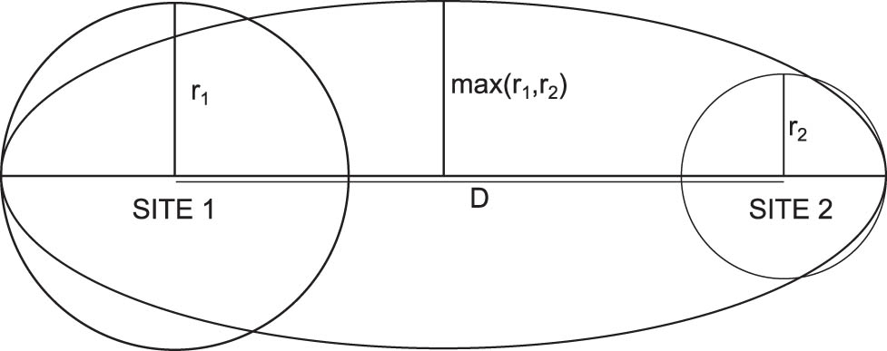
Re-estimated settlement extension known from a pair of matching sites.
4 Results: Updated (Spatial) Evolutionary Trajectories of Settlements
Eighteen sites have been reconstructed based on the combination of matching archaeological sites detected under the 100 m limit. This number is lower than the number of matching sites according to the Galatas publication because it corresponds to the total number of settlements that are composed of multiple sites at less than 100 m from each other with the limitation of having at least one occupation period within the LM II–Hellenistic period timeframe, other periods not being included in this study. Three pairs of sites mentioned as already published in the Pediada survey’s publication by the Galatas survey team are outside of the 100 m limit and therefore have not been detected and presented as matching sites in this article. They are located at Prophitis Ilias-Arkalochori (G28), Kastellous B-Zoophoroi (G68), and Nira or Papouria-Astritsi (G91). In the first case, the two sites are located more than 400 m from each other. This is admittedly the result of the difficulty of locating the site that lies under the modern town of Arkalochori. The two other cases, with sites 200–300 m from each other, are likely not matching sites.
The chronological distribution of these detected matching sites shows important differences, from 14 matches detected for the LM III A2 period to only one in the LM II and two in the Classical period (Table 3). Not all detected matches have led to a reassessment of the category of settlements because some recomposed sites still fit within the previously assessed categories’ definition based on their total area. In total, 52% of the detected matching occupations (34 out of 65) led to a reassessment of the category of settlements. Most matching occupations were already described as hamlets or have been reclassified as such (24 matches, including 18 new hamlets) or villages (21 matches, including 16 new villages).
Settlements documented by matching archaeological sites detected in the Galatas area
| Number of settlements composed of matching sites | |||||||
|---|---|---|---|---|---|---|---|
| Farmstead | F/H | Hamlet | H/V | Village | Town | Total | |
| LM II | 0 | 0 | 1 (1) | 0 | 0 | 0 | 1 (1) |
| LM III A1 | 3 (0) | 0 | 4 (2) | 0 | 5 (4) | 0 | 12 (6) |
| LM IIIA2 | 3 (0) | 0 | 5 (3) | 0 | 6 (5) | 0 | 14 (8) |
| LM IIIB | 2 (0) | 0 | 5 (3) | 0 | 6 (5) | 0 | 13 (8) |
| LM IIIC | 0 | 0 | 4 (4) | 0 | 2 (2) | 0 | 6 (6) |
| PG | 0 | 0 | 2 (2) | 0 | 0 | 1 (0) | 3 (2) |
| G | 0 | 0 | 2 (2) | 1 (0) | 1 (0) | 1 (0) | 5 (2) |
| O | 0 | 0 | 0 | 0 | 1 (0) | 2 (0) | 3 (0) |
| A | 0 | 0 | 1 (1) | 0 | 0 | 2 (0) | 3 (1) |
| C | 0 | 0 | 0 | 0 | 0 | 2 (0) | 2 (0) |
| H | 0 | 0 | 0 | 1 (0) | 0 | 2 (0) | 3 (0) |
| Total | 8 (0) | 0 | 24 (18) | 2 (0) | 21 (16) | 10 (0) | 65 (34) |
Note: Numbers in brackets correspond to newly assigned settlement categories.
The evolutionary trajectories of settlements composed of matching archaeological sites, delineating the evolution of the settlement categories over time (Drillat, 2022a), are presented in Tables 4–6. A quadruplet (M1) has been detected at Voni, composed of four sites all discovered during the Pediada survey (Table 4). Among these four archaeological sites, not more than two are occupied at the same time. Table 5 then presents two triplets of archaeological sites that have been detected at Astritsi (Kephala and Hagios Ioannis). The first triplet M2 is composed of Kephala (Lykastos)-Astritsi, G24 Astritsi Kephala, and G86. The link between G86 and the two recorded sites of Kephala-Astritsi is however not very strong: G86 is only under the 100 m limit from Kephala (Lykastos)-Astritsi when it is unoccupied and Kephala is a large town. During its occupation periods (LM III A–B), it is located more than 100 m from Kephala and therefore not considered to be the same settlement. Similarly, the second triplet M3 is composed of G96 Hagios Ioannis Theologos, G97, and Nira or Haghios Ioannis-Astritsi but the first is only located less than 100 m from the others when unoccupied and farther during its occupation periods (Classical and Hellenistic). Fifteen pairs of archaeological sites have also been detected under the 100 m limit (Table 6). Among these pairs, 2 are composed of 2 sites from the Pediada survey and in the remaining 13, 5 were not acknowledged by the Galatas survey publication to be already recorded in the Pediada survey. The two sites that compose M12 are recorded at the exact same location, admittedly because the coordinates of the site recorded by the Pediada survey were reused in the Galatas survey database. Such a duplication does not enable the production of any additional data with the present methodology.
Evolutionary trajectories of the four archaeological sites of the settlement at Voni
| LM II | LM IIIA1 | LM IIIA2 | LM IIIB | LM IIIC | PG | G | O | A | C | H | |
|---|---|---|---|---|---|---|---|---|---|---|---|
| Archondika or Kato Pigai-Voni | F | F | F | ||||||||
| To | 78.2 (128.6) | 78.2 (128.6) | 78.2 (128.6) | ||||||||
| Haghios Georghios-Voni | F | F | F | F | F | F | F | ||||
| Archondika or Kato Pigai-Voni/Haghios Georghios-Voni | H | H | H | ||||||||
| Archondika or Kato Pigai-Voni | F | F | — | — | F | ||||||
| To | 93.8 (119) | 93.8 (119) | 93.8 (119) | 93.8 (119) | 93.8 (119) | ||||||
| Kalogeridis plot-Voni | — | — | F | F | — | ||||||
| Archondika or Kato Pigai-Voni/Kalogeridis plot-Voni | F | F | F | F | F | ||||||
| Haghios Georghios-Voni | F | — | F | F | F | — | F | — | F | F | — |
| To | 43.2 (68.5) | 68.5 (68.5) | 43.2 (68.5) | 43.2 (68.5) | 43.2 (68.5) | 43.2 (68.5) | 18 (68.5) | 68.5 (68.5) | 43.2 (68.5) | 43.2 (68.5) | 68.5 (68.5) |
| Kalogeridis plot-Voni | — | — | — | — | — | F | F | — | — | — | — |
| Haghios Georghios-Voni/Kalogeridis plot-Voni | F | — | F | F | F | F | H | — | F | F | — |
| Haghios Georghios-Voni | F | — | F | F | F | — | F | — | F | F | — |
| To | 44.4 (94.9) | 94.9 (94.9) | 69.6 (94.9) | 69.6 (94.9) | 69.6 (94.9) | 69.6 (94.9) | 69.6 (94.9) | 94.9 (94.9) | 69.6 (94.9) | 69.6 (94.9) | 94.9 (94.9) |
| Sochora-Voni | F | — | — | — | — | F | — | — | — | — | — |
| Haghios Georghios-Voni/Sochora-Voni | H | — | F | F | F | F | F | — | F | F | — |
| Kalogeridis plot-Voni | — | — | — | — | — | F | F | — | — | — | — |
| To | 20.9 (71.4) | ||||||||||
| Sochora-Voni | F | — | — | — | — | F | — | — | — | — | — |
| Kalogeridis plot-Voni/Sochora-Voni | F | — | — | — | — | H | F | — | — | — | — |
| M1 | H | — | H | H | F | H | H | — | H | F | — |
Note: The evolutionary trajectories of each matching site are presented, followed in grey by the reconstructed evolutionary trajectory of the settlement composed of multiple sites (with updated settlement categories in bold). The distances in meters indicated are between the limits of the sites and in brackets between the two centers. Distances are only given between two occupations closer than 100 m one from the other. Settlement categories are indicated by F for farmstead, H for hamlet, V for village, and T for town. “–” means the site is unoccupied at the given period, but located less than 100 m from another occupied site.
Evolutionary trajectories of triplets of sites (see Table 4 for abbreviations and format)
| LM II | LM IIIA1 | LM IIIA2 | LM IIIB | LM IIIC | PG | G | O | A | C | H | |
|---|---|---|---|---|---|---|---|---|---|---|---|
| Kephala (Lykastos)-Astritsi/G86 | T | T | T | T | T | T | |||||
| G86 | F | F | F | — | — | — | — | — | — | ||
| To | |||||||||||
| Kephala (Lykastos)-Astritsi | H/V | H/V | H/V | H/V | T | T | T | T | T | T | |
| To | 29.5 (130) | 29.5 (130) | 29.5 (130) | 37.6 (130) | 0 (130) | 0 (130) | 0 (130) | 0 (130) | 0 (130) | 0 (130) | |
| G24 Astritsi Kephala | H | H | H | F/H | T | T | T | T | T | T | |
| M2 | V | V | V | V | T | T | T | T | T | T | |
| G96 Hagios Ioannis Theologos/G97 | V | V | V | ||||||||
| G96 Hagios Ioannis Theologos | — | — | — | F | F | ||||||
| To | |||||||||||
| G97 | — | F | F | F | F/H | V | V | V | — | — | — |
| To | 0 (87.5) | ||||||||||
| Nira or Haghios Ioannis-Astritsi | — | — | — | — | — | — | — | F | F | — | — |
| M3 | — | F | F | F | F/H | V | V | V | F | F | F |
Evolutionary trajectories of pairs of sites (see Table 4 for abbreviations and format)
| LM II | LM IIIA1 | LM IIIA2 | LM IIIB | LM IIIC | PG | G | O | A | C | H | |
|---|---|---|---|---|---|---|---|---|---|---|---|
| Kolomodis or Berdai To Monastiri-Haghies Paraskies | F | F | F | F | |||||||
| To | 63.6 (127) | 63.6 (127) | 63.6 (127) | ||||||||
| G99 Chani Tou Tsapino Michalis | H | H | H | F | F | F | F | F | |||
| M4 | V | V | V | ||||||||
| Trochaloi-Sambas | — | F | F | F | F | F | F | — | — | — | — |
| To | 0 (46.2) | 0 (46.2) | 0 (46.2) | 0 (46.2) | 0 (46.2) | 0 (46.2) | |||||
| G80 Trochaloi Hill | — | H | H | H | F/H | F | F | F | F | F | p |
| M5 | — | H | H | H | H | H | H | F | F | F | p |
| Pezoulia-Thrapsano | — | F | F | F | F | — | — | — | — | — | — |
| to | 38.7 (76.5) | 38.7 (76.5) | 38.7 (76.5) | ||||||||
| G54 | — | F | F | F | — | — | — | — | — | — | — |
| M6 | — | H | H | H | F | — | — | — | — | — | — |
| Sochora A-Thrapsano | — | F | F | F | F | — | — | — | F | — | — |
| to | 0 (23.6) | 0 (23.6) | 0 (23.6) | ||||||||
| G50 | — | F | F | F | — | — | — | — | — | — | — |
| M7 | — | F | F | F | F | — | — | — | F | — | — |
| Petras Amarathia-Voni | — | — | — | — | — | F | — | — | F | — | — |
| to | |||||||||||
| G83 Petras Amarathia | — | V | V | V | — | — | — | — | — | — | — |
| M8 | — | V | V | V | — | F | — | — | F | — | — |
| Kastellous A-Zoophori | F | F | F | F | |||||||
| to | 58 (108.5) | 58 (108.5) | 58 (108.5) | 58 (108.5) | |||||||
| Kastellous B-Zoophori | F | F | F | F | |||||||
| M9 | H | H | H | H | |||||||
| Petras-Archondiko | H/V | H/V | H/V | H/V | |||||||
| to | 89.7 (182) | 89.7 (182) | 89.7 (182) | 89.7 (182) | |||||||
| G22 Mandres | F/H | F/H | F/H | F/H | F/H | F/H | F/H | F/H | |||
| M10 | V | V | V | V | |||||||
| Trochaloi-Apostoli | H/V | H/V | H/V | H/V | |||||||
| to | 73.2 (155) | 73.2 (155) | 73.2 (155) | ||||||||
| G55 Trochaloi | F | F | F | — | F | F | |||||
| M11 | V | V | V | H/V | |||||||
| Vatos-Apostoli | — | F | F | F | F | — | — | — | — | — | — |
| to | 0 | 0 | 0 | ||||||||
| G162 | — | p | p | p | — | — | — | — | — | — | — |
| M12 | — | F | F | F | F | — | — | — | — | — | — |
| Mavros Spilios-Alagni | — | — | H/V | H/V | H/V | — | — | — | H/V | H/V | H/V |
| to | 0 (45.5) | 0 (45.5) | |||||||||
| G109 | — | F | F | F | — | — | — | — | — | — | — |
| M13 | — | F | V | V | H/V | — | — | — | H/V | H/V | H/V |
| Rouma (Kato)-Alagni | — | F | F | — | — | — | — | — | — | — | — |
| to | 0 | 0 | |||||||||
| Rouma (Kato) or Galiotes-Astritsi | — | F | F | F | F | F | F | — | — | — | — |
| M14 | — | F | F | F | F | F | F | — | — | — | — |
| Kephala-Choumeri | — | T | T | T | T | — | — | T | T | T | T |
| to | 0 (12.9) | 0 (12.9) | 0 (12.9) | 0 (12.9) | |||||||
| G140 Choumeri Kephala | — | — | — | — | — | T | T | T | T | T | T |
| M15 | — | T | T | T | T | T | T | T | T | T | T |
| Galatas Kephala-Galatas | F | F | F | F | F | — | — | — | — | — | — |
| to | 0 (81.6) | 0 (81.6) | 0 (81.6) | 20.7 (81.6) | |||||||
| G44 Galatiani Kephala | — | V | V | V | F/H | F | F | F | V | H | V |
| M16 | F | V | V | V | H | F | F | F | V | H | V |
| Platia Strata-Galatas | — | — | — | — | — | — | H/V | — | — | — | — |
| to | 0 | ||||||||||
| G160 | — | — | — | — | — | — | H | — | — | — | — |
| M17 | — | — | — | — | — | — | H/V | — | — | — | — |
| Gaidouropetra-Gazi | — | F | F | F | F | — | F | — | F | — | — |
| to | 0 (22.0) | 0 (22.0) | 0 (22.0) | 0 (22.0) | 0 (22.0) | ||||||
| G157 Paratiritirion | — | H | H | H | F/H | V | V | V | — | — | — |
| M18 | — | H | H | H | H | V | V | V | F | — | — |
5 Discussion
5.1 Location Data Quality Control based on Matching Sites
After identifying matching sites, additional controls on data quality can be performed before interpreting results. Sites located in a close spatial relationship, as the matching sites detected in this article, have been considered in previous studies as two records of the same site, one of the records, often the oldest, being considered wrong, or at least less accurate. It has already been suggested that inherent errors in the spatial data of the Pediada and Galatas surveys are unlikely. Then, Ullah suggested that correctable errors can be detected by the analysis of the offset between an initial survey and a resurvey (Ullah, 2015). Particularly, systematic technical issues in the spatial recording of both datasets can be excluded by looking at the pairwise dissimilarity in the location of matching archaeological sites (Figure 4). This polar plot presents both the offset distance between recorded locations of matching sites and a directional analysis of this offset. If the difference was due to a systematic difference in recording (e.g., land survey equipment settings, used Coordinate Reference System in a Geographic Information System), dots in the polar plot would cluster in a single zone. The observed dispersion excludes this possibility.

Distance and angle of offset between the site locations recorded during the Pediada survey and the site locations recorded during the Galatas survey.
Variations in spatial data between two consecutive surveys can also be linked to various biases (García Sánchez et al., 2017). Taphonomic processes can occur between two surveys and introduce biases. To exclude the possibility that erosion may have produced horizontal movement of artifacts downhill following the slope’s orientation and impacted the recorded location of sites, two straightforward analyses can be performed. First, it is possible to compare the distance between recorded places of matching sites with the value of the slope (Figure 5a). Second, the orientation of the axis between two archaeological sites can be compared with the orientation of the slope (Figure 5b). Only pairs of archaeological sites that have been detected as matching and which have been recorded one during the Pediada survey and the other during the Galatas survey are considered in Figure 5. No correlation is detected in both cases, excluding movements due to erosion as a cause of double records.

(a) Distance between matching archaeological sites as a function of the slope. (b) Relation between the orientation of the axis between matching archaeological sites and the orientation of the slope. In both sub-figures, the sites plotted are only pairs of sites that combine a record from the Pediada survey and a record from the Galatas survey.
Additionally, one could argue that, due to the difficulty of properly estimating site size during surveys, variations in location data could only be the result of imprecision in recording induced by larger scatters. However, no correlation appears between the maximum site size and the distance between recording places of matching sites (Figure 6), excluding this possibility.

Relation between the distance between matching archaeological sites and their maximum recorded extension for all paired sites, including within triplets or quadruplets, and within the same survey project.
After pairing matching sites, the impact of obvious biases in location data seems negligible. Additionally, it appears that inherent and correctable systematic errors cannot be found in the dataset. Hence, the assumption that multiple archaeological records of the same ancient settlements can be used and combined to gain more information on these settlements appears to be strengthened, comforting the results of the present study.
5.2 Hierarchical and Spatial Evolution of Central Cretan Settlements
The restudy of survey data to detect matching archaeological sites can improve archaeological narratives at both site scale and regional scale. This approach provides new possibilities for studying intra-site spatial dynamics of settlements: when ancient settlements are perceived through multiple sites, the internal dynamics of their spatial organization can be perceived. This is the case at Voni (M1), which has the most sites known within the case study area (Figure 7). On that site, which oscillates between a farmstead and a hamlet and presents a very long occupation history from the LM II to the Classical period, developments and retractions in the spatial extension of the settlement can be observed thanks to the detection of four matching sites. The small movements of the settlement observed across its occupation period could also be explained by the rebuilding of small farms in a nearby location after a few generations. Although this approach depends strongly on survey data quality and will never produce information on the spatial and settlement dynamics as reliable as excavations, it enables us to reuse legacy data and provides a low-cost tool to get additional information on settlement dynamics. The proposed method allows us to study the evolution of the spatial morphology of settlements, as an intra-site survey would do for larger settlements (Bintliff, 2013; Poblome et al., 2013), but here for multiple small rural sites.

Spatial dynamics of the settlement at Voni (M1) from the Late Minoan II to the Hellenistic period, on the basis of archaeological sites’ occupation.
The method developed in this article also produces new information on spatial dynamics at a regional scale. Based on the case study of the Galatas area, this article provides new insights into the territorial organization of this small area in central Crete. The new evolutionary trajectories of settlements that combine matching sites (Tables 4–6) enable us to produce updated archaeological maps of the area for each period (Figure 8). On these maps, notably different from the archaeological maps based solely on the Pediada or Galatas surveys (Figure 9), matching occupations are represented by a single square marker, bounded in black when the settlement category has been updated in this study.

Archaeological maps of the Galatas area with updated settlement categories, from the Late Minoan II to the Hellenistic period.

Comparison of archaeological maps of the Galatas area based independently on the Pediada survey and the Galatas survey, from the Late Minoan II to the Hellenistic period.
The final publication of the Galatas survey provides a general history of settlement patterns from LM II to Hellenistic times (Buell & Turner, 2017; Gallimore, 2017; Turner, 2017) which has been restudied recently (Pollard, 2022). However, this study complements previous interpretations by providing new information on settlements’ hierarchies. The LM II period is very poorly known in the Galatas area. No occupation was found during the Galatas survey, and only four small sites were recorded during the Pediada survey. This study suggests that two of these small sites were a hamlet, which would be the only (small) grouped habitation site known in the area at that time. During the LM III A-B periods, the territory was split between many villages (Buell & Turner, 2017, p. 80). This study suggests an even more split landscape than previously supposed with four new villages during LM III A1 and five new villages during LM III A2 and LM III B. In addition, new small hamlets have been characterized, completing the picture of a densely occupied rural landscape. Following Panagiotakis’s publication of the Pediada survey, Kephala-Choumeri (M15) appears to be the only town in the area occupied between LM IIIA and LM IIIC (Panagiotakis, 2003, p. 388). However, no clear LM III B pottery has been published from that site in a later publication of the LM III B pottery from the Pediada survey project (Paschalidis et al., 2017). The importance of Kephala-Choumeri might be overestimated because of the lack of information on the evolutionary trajectories in the available publications of the Pediada survey. It is therefore not clear if Kephala-Choumeri was on top of the hierarchy or a settlement among others during LM III. The LM III C period is described in previous publications as a period of retraction, with an important decrease in the number of sites and especially of large settlements (Buell & Turner, 2017, pp. 80–81; Panagiotakis, 2003, p. 354). The same conclusion can be proposed here, but this article’s results alter the picture of the abandonment of large sites, with two settlements reclassified as villages that continued to be occupied in LM III C. In the following Protogeometric period, the number of villages increased (Buell & Turner, 2017). Here again, this picture is nuanced by this study’s results. No new villages have been detected for the Protogeometric period, but the two additional villages in LM III C make the increase between LM III C and Protogeometric less important. Two towns, at Kephala-Astritsi (M2) and Kephala-Choumeri, polarize space in the Protogeometric period (Turner, 2017). Combined with the decrease in smaller sites, this suggests a nucleation phenomenon as also observed elsewhere in Crete in the Protogeometric period (Gaignerot-Driessen, 2016, pp. 172–173; 2018; Pollard, 2023; Wallace, 2010). In the Geometric to Hellenistic periods, the settlement patterns are quite similar to the Protogeometric occupation of the territory. Hence, the territorial organization appears to be very stable from the Protogeometric period as in the neighboring Anapodaris catchment areas (Drillat, 2022a). This territorial stability continues over the Archaic to Hellenistic periods, as already observed elsewhere in Crete (Drillat, 2022b). Only small rural sites whose function has been studied recently (Erny, 2022; Gallimore, 2017) appear and disappear, again, as “traffic lights.”
6 Conclusion
Archaeological surveys are a crucial tool for studying settlement dynamics in the ancient world, but they are subject to various biases that can impact the validity of their results. This article proposes to acknowledge the important spatial variability of visibility parameters by considering that what is recorded as a site is only a window on an ancient settlement. Therefore, it is necessary to consider that multiple survey sites could be windows on the same ancient settlement. In the context of resurveyed areas, as in the developed case study of the Galatas area in central Crete, variability in survey results can be related to moving windows on ancient settlements from one survey to another. Identifying matching archaeological sites that reflect the same ancient occupation enables the reevaluation of site size and settlements classification and chronology, as well as the study of their spatial morphology and evolution. The maximum distance between two sites to consider them as matching can be adjusted depending on the local context. Finally, to really understand if sites should be combined or not in future survey projects, a very careful study of visibility should be conducted. Recording and mapping visibility parameters, and so visibility windows, appear to be as important as recording and mapping artifacts to get a better understanding of ancient settlements.
Acknowledgments
The author thanks Dr. Buell who shared data on the Galatas survey sites, and the editorial team and anonymous reviewers whose suggestions significantly improved the quality of the manuscript. A preliminary version of this study benefitted from the remarks and comments of the organizers and participants of the Enlight/U4 Ancient World Winter School 2022.
-
Funding information: This research received no specific funding.
-
Author contribution: The author confirms the sole responsibility for the conception of the study, presented results, and manuscript preparation.
-
Conflict of interest: The author states no conflict of interest.
-
Data availability statement: The datasets generated during and/or analysed during the current study are available from the corresponding author on reasonable request.
References
Alcock, S. E. (1993). Surveying the peripheries of the hellenistic world. In P. Bilde (Ed.), Centre and periphery in the Hellenistic world: Vol. Studies in Hellenistic civilization (pp. 162–175). Aarhus University Press.Suche in Google Scholar
Alessandri, L. (2015). Exploring territories: Bubble model and minimum number of contemporary settlements. A case study from Etruria and Latium Vetus from the Early Bronze Age to the Early Iron Age. Origini, XXXVII(1), 175–199.Suche in Google Scholar
Almagro-Gorbea, M., & Benito-López, J. E. (1996). Control de calidad en resultados en prospección arqueológica. Complutum, 7, 251–264.Suche in Google Scholar
Almagro-Gorbea, M., Alonso, P., Benito, J. E., Martín, A. M., & Valencia, J. L. (2002). Statistical quality control in archaeological survey. Archaeological Prospection, 9(2), 45–53. doi: 10.1002/arp.179.Suche in Google Scholar
Ammerman, A. J., Koster, H., & Pfenning, E. (2013). The longitudinal study of land-use at Acconia: Placing the fieldwork of the survey archaeologist in time. Journal of Field Archaeology, 38(4), 291–307. doi: 10.1179/0093469013Z.00000000060.Suche in Google Scholar
Attema, P., Bintliff, J., van Leusen, M., Bes, P., de Haas, T., Donev, D., Jongman, W., Kaptijn, E., Mayoral, V., Menchelli, S., Pasquinucci, M., Rosen, S., Sánchez, J. G., Soler, L. G., Stone, D., Tol, G., Vermeulen, F., & Vionis, A. (2020). A guide to good practice in Mediterranean surface survey projects. Journal of Greek Archaeology, 5, 1–62.10.32028/9781789697926-2Suche in Google Scholar
Attema, P., Burgers, G.-J. L. M., & Leusen, M. van. (2010). Regional pathways to complexity: Settlement and land-use dynamics in early Italy from the Bronze Age to the Republican period. Amsterdam University Press.10.26530/OAPEN_408880Suche in Google Scholar
Attema, P., Carafa, P., Jongman, W. M., Smith, C. J., Bronkhorst, A. J., Capanna, M. C., De Haas, T. C. A., Van Leusen, P. M., Tol, G. W., Witcher, R. E., & Wouda, N. A. (2021). The Roman Hinterland Project: Integrating archaeological field surveys around Rome and beyond. European Journal of Archaeology, 25(2), 238–258. doi: 10.1017/eaa.2021.51.Suche in Google Scholar
Attema, P., & van Leusen, M. (2004). Intra-regional and interregional comparison of occupation histories in three Italian regions: The RPC project. In S. E. Alcock & J. F. Cherry (Eds.), Side-by-side survey: Comparative regional studies in the Mediterranean world (pp. 86–100). Oxbow Books. https://www.jstor.org/stable/j.ctt1s474xp.Suche in Google Scholar
Banning, E. B. (2002). Archaeological survey. Springer. doi: 10.1007/978-1-4615-0769-7.Suche in Google Scholar
Banning, E. B., Hawkins, A. L., Stewart, S. T., Hitchings, P., & Edwards, S. (2017). Quality assurance in archaeological survey. Journal of Archaeological Method and Theory, 24(2), 466–488. doi: 10.1007/s10816-016-9274-2.Suche in Google Scholar
Bintliff, J. (1997). Regional survey, demography, and the rise of complex societies in the ancient Aegean: Core-periphery, neo-Malthusian, and other interpretive models. Journal of Field Archaeology, 24(1), 1–38. doi: 10.1179/jfa.1997.24.1.1.Suche in Google Scholar
Bintliff, J. (2013). Intra-site artefact surveys. In C. Corsi, B. Slapšak, & F. Vermeulen (Eds.), Good practice in archaeological diagnostics (pp. 193–207). Springer International Publishing. doi: 10.1007/978-3-319-01784-6_11.Suche in Google Scholar
Bonnier, A., Finné, M., & Weiberg, E. (2019). Examining land-use through GIS-based kernel density estimation: A re-evaluation of legacy data from the berbati-limnes survey. Journal of Field Archaeology, 44(2), 70–83. doi: 10.1080/00934690.2019.1570481.Suche in Google Scholar
Buell, D. M., & Turner, L. A. (2017). Collapse and retraction. In L. V. Watrous, D. M. Buell, E. Kokinou, P. Soupios, A. Sarris, S. Beckmann, G. Rethemiotakis, L. A. Turner, S. Gallimore, & M. D. Hammond, The Galatas survey: The socio-economic and political development of a contested territory in central crete during the Neolithic to Ottoman periods. INSTAP Academic Press. doi: 10.2307/j.ctt1wrpwkj.Suche in Google Scholar
Casarotto, A. (2017). A method for modeling dispersed settlements: Visualizing an early Roman colonial landscape as expected by conventional theory. Archeologia e Calcolatori, 28, 147–163.Suche in Google Scholar
Casarotto, A. (2018). Spatial patterns in landscape archaeology: A GIS procedure to study settlement organization in early Roman colonial territories. Leiden University Press.Suche in Google Scholar
Casarotto, A., García Sánchez, J., Stek, T. D., & Pelgrom, J. (2021). Surface visibility and the validity of settlement patterns in legacy survey datasets. The Journal of Fasti Online, 17.Suche in Google Scholar
Casarotto, A., Stek, T. D., Pelgrom, J., van Otterloo, R. H., & Sevink, J. (2018). Assessing visibility and geomorphological biases in regional field surveys: The case of Roman Aesernia. Geoarchaeology, 33(2), 177–192. doi: 10.1002/gea.21627.Suche in Google Scholar
Cloke, C., & Athanassopoulos, E. (2020). Late Antique and Medieval Landscapes of the Nemea Valley, Southern Greece. Journal of Greek Archaeology, 5, 406–425. doi: 10.32028/9781789697926-15.Suche in Google Scholar
Driessen, J. (2001). History and hierarchy. Preliminary observations on the settlement pattern of Minoan crete. In K. Branigan (Ed.), Urbanism in the Aegean Bronze Age (pp. 51–71). Sheffield Academic Press.Suche in Google Scholar
Drillat, Q. (2022a). Long-term spatial dynamics and city-state development in the Anapodaris catchment (south-central Crete, Greece). BABESCH, 97, 1–22. doi: 10.2143/BAB.97.0.3290530.Suche in Google Scholar
Drillat, Q. (2022b). Modeling Greek city-states’ territories with Least-Cost Site Catchment analysis: A case study of Lato, Crete. Journal of Archaeological Science: Reports, 42, 103378. doi: 10.1016/j.jasrep.2022.103378.Suche in Google Scholar
Erny, G. (2022). Landscapes of inequality: Social differentiation in geometric through classical crete. (PhD thesis). Stanford University. https://purl.stanford.edu/vy130vd2824.Suche in Google Scholar
Gaignerot-Driessen, F. (2016). De l’occupation postpalatiale a la cite-etat grecque: Le cas du Mirambello Crete. Peeters.Suche in Google Scholar
Gaignerot-Driessen, F. (2018). La formation des cités grecques (XIVe s.- VIIe s. av. n. è.): Approche archéologique à partir de quelques cas crétois. Revue des Etudes Grecques, 2018(1), 49–73.10.3406/reg.2018.8547Suche in Google Scholar
Gallimore, S. (2017). Population Retraction during the Hellenistic Period. In L. V. Watrous, D. M. Buell, E. Kokinou, P. Soupios, A. Sarris, S. Beckmann, G. Rethemiotakis, L. A. Turner, S. Gallimore, & M. D. Hammond (Eds.), The Galatas survey: The socio-economic and political development of a contested territory in central crete during the Neolithic to Ottoman periods. INSTAP Academic Press. doi: 10.2307/j.ctt1wrpwkj.Suche in Google Scholar
García Sánchez, J., Pelgrom, J., & Stek, T. D. (2017). Comparing re-surveys in Isernia and Venosa (Molise And Basilicata, Italy). Mediterranean Archaeology and Archaeometry, 17(3), 39–52. doi: 10.5281/ZENODO.1005454.Suche in Google Scholar
Hope Simpson, R., Betancourt, P. P., Callaghan, P. J., Harlan, D. K., Hayes, J. W., Shaw, J. W., Shaw, M. C., & Watrous, L. V. (1995). Chapter 7. The archaeological Survey of the Kommos Area. In J. W. Shaw & M. C. Shaw (Eds.), Kommos. I. The Kommos region and houses of the Minoan town. Part 1. The Kommos region, ecology and Minoan industries (pp. 325–402). Princeton UnivPress.10.1515/9781400852956.325Suche in Google Scholar
Iao, K. (2017). Appendix A. Register of sites. In L. V. Watrous, D. M. Buell, E. Kokinou, P. Soupios, A. Sarris, S. Beckmann, G. Rethemiotakis, L. A. Turner, S. Gallimore, & M. D. Hammond (Eds.), The Galatas survey: The socio-economic and political development of a contested territory in central crete during the Neolithic to Ottoman periods. INSTAP Academic Press. doi: 10.2307/j.ctt1wrpwkj.Suche in Google Scholar
Kearns, C. (2022). The rural landscapes of archaic cyprus: An archaeology of environmental and social change. Cambridge University Press. doi: 10.1017/9781009071826.Suche in Google Scholar
Knodell, A. (2021). Societies in transition in early Greece: An archaeological history. University of California Press. doi: 10.1525/luminos.101.Suche in Google Scholar
Knodell, A., Wilkinson, T. C., Leppard, T. P., & Orengo, H. A. (2023). Survey archaeology in the Mediterranean world: Regional traditions and contributions to long-term history. Journal of Archaeological Research, 31, 263–329. doi: 10.1007/s10814-022-09175-7.Suche in Google Scholar
Lloyd, J., & Barker, G. (1981). Rural settlement in Roman Molise: Problems of archaeological survey. In G. Barker & G. Hodges (Eds.), Archaeology and Italian society (pp. 289–304). Oxford: BAR.Suche in Google Scholar
Naylor, L. L. (1981). Archaeological site survey: Some sociocultural perspectives. North American Archaeologist, 2(1), 1–17. doi: 10.2190/JFC3-AQ0N-9B8G-A31D.Suche in Google Scholar
Panagiotakis, N. (2003). L’évolution archéologique de la Pédiada (Crète centrale): Premier bilan d’une prospection. Bulletin de correspondance hellénique, 127(2), 327–430. doi: 10.3406/bch.2003.7322.Suche in Google Scholar
Panagiotakis, N. (2004). Contacts between Knossos and the Pediada region in central Crete. British School at Athens Studies, 12, 177–186.Suche in Google Scholar
Panagiotakis, N., Panagiotaki, M., Guzowska, M., & Paschalidis, K. (2011). Mελετώντας τη Mέση και την Ύστερη Eποχή του Xαλκού στην επαρχία Πεδιάδας της κεντρικής Kρήτης. In M. Andreadaki-Vlazaki & E. Papadopoulou (Eds.), Πεπραγμένα I´ Διεθνούς Kρητολογικού Συνεδρίου (Xανιά, 1–8 Oκτωβρίου 2006) (Vol. A2, pp. 747–773). Philological Association ‘Chrysostomos.’Suche in Google Scholar
Parini, M. C. (2020). Hellenistic and Roman landscapes of Southern Italy: Integration and comparison of field survey data for settlement and land use analysis. Tijdschrift Voor Mediterrane Archeologie, 64, 55.Suche in Google Scholar
Paschalidis, K., Panagiotakis, N., & Panagiotaki, M. (2017). Sherds of a Century: The LM IIIB Pottery from the Pediada Survey Project. Elements for the Distribution and the Character of Life in Central Crete, during the 13th c. BC. In C. Langohr (Ed.), How Long is a Century? Late Minoan IIIB Pottery, Relative Chronology and Regional Differences (pp. 153–192). Presses Universitaires de Louvain.Suche in Google Scholar
Plog, S., Plog, F., & Wait, W. (1978). Decision making in modern surveys. Advances in Archaeological Method and Theory, 1, 383–421.10.1016/B978-0-12-003101-6.50016-0Suche in Google Scholar
Poblome, J., Willet, R., Firat, N., Martens, F., & Bes, P. (2013). Tinkering with urban survey data. How many Sagalassos-es do we have? In P. Johnson & M. Millett (Eds.), Archaeological survey and the city (pp. 146–174). Oxbow Books. https://www.torrossa.com/gs/resourceProxy?an=4914822&publisher=FZ6430#page=155.10.2307/j.ctvh1dwwz.10Suche in Google Scholar
Pollard, D. (2022). Between the Mountains and the Sea: Landscapes of Settlement, Subsistence and Funerary Practice in Later Bronze Age and Iron Age Crete. [PhD thesis]. University College London.Suche in Google Scholar
Pollard, D. (2023). The history of settlement in Late Bronze Age and Early Iron Age Crete: A review and synthesis. Journal of Greek Archaeology, 8, 104–146.Suche in Google Scholar
Rethemiotakis, G. (2017). Excavation of the Minoan Palace and Town of Galatas. In L. V. Watrous, D. M. Buell, E. Kokinou, P. Soupios, A. Sarris, S. Beckmann, G. Rethemiotakis, L. A. Turner, S. Gallimore, & M. D. Hammond (Eds.), The Galatas survey: The socio-economic and political development of a contested territory in central crete during the Neolithic to Ottoman periods. INSTAP Academic Press. doi: 10.2307/j.ctt1wrpwkj.Suche in Google Scholar
Schiffer, M., Sullivan, A., & Kilinger, T. (1978). The design of archaeological surveys. World Archaeology, 10, 1–28. doi: 10.1080/00438243.1978.9979712.Suche in Google Scholar
Spencer, C., & Bevan, A. (2018). Settlement location models, archaeological survey data and social change in Bronze Age Crete. Journal of Anthropological Archaeology, 52, 71–86. doi: 10.1016/j.jaa.2018.09.001.Suche in Google Scholar
Stefanakis, M. I. (2011). Aρχαική ανάγλυφη κεραμική από την Πεδιάδα. In M. Andreadaki-Vlazaki & E. Papadopoulou (Eds.), Πεπραγμένα I´ Διεθνούς Kρητολογικού Συνεδρίου (Xανιά, 1–8 Oκτωβρίου 2006) (Vol. A2, pp. 775–788). Philological Association ‘Chrysostomos.’Suche in Google Scholar
Terrenato, N. (2004). Sample size matters! The paradox of global trends and local surveys. In S. E. Alcock & J. F. Cherry (Eds.), Side-by-side survey: Comparative regional studies in the Mediterranean world (pp. 36–48). Oxbow Books. https://www.jstor.org/stable/j.ctt1s474xp.Suche in Google Scholar
Terrenato, N., & Ammerman, A. J. (1996). Visibility and site recovery in the Cecina Valley Survey, Italy. Journal of Field Archaeology, 23, 91–109.10.1179/009346996791973990Suche in Google Scholar
Thompson, S. (2004). Side-by-Side and Back-to-Front: Exploring intra-regional latitudinal and longitudinal comparability in survey data. Three case studies from Metaponto, Southern Italy. In S. E. Alcock & J. F. Cherry (Eds.), Side-by-side survey: Comparative regional studies in the Mediterranean world (pp. 65–85). Oxbow Books. https://www.jstor.org/stable/j.ctt1s474xp.Suche in Google Scholar
Turner, L. A. (2017). Population reduction and a polis. In L. V. Watrous, D. M. Buell, E. Kokinou, P. Soupios, A. Sarris, S. Beckmann, G. Rethemiotakis, L. A. Turner, S. Gallimore, & M. D. Hammond (Eds.), The Galatas survey: The socio-economic and political development of a contested territory in central crete during the Neolithic to Ottoman periods. INSTAP Academic Press. doi: 10.2307/j.ctt1wrpwkj.Suche in Google Scholar
Ullah, I. I. T. (2015). Integrating older survey data into modern research paradigms: Identifying and correcting spatial error in “Legacy” Datasets. Advances in Archaeological Practice, 3(4), 331–350. doi: 10.7183/2326-3768.3.4.331.Suche in Google Scholar
van den Eijnde, F., Docter, R. F., Brüsewitz, A., Nazou, M., & Stal, C. (2021). The 2012–2017 Ghent-Utrecht survey project at Thorikos: Preliminary observations on the final neolithic and bronze age settlement. In R. F. Docter & M. Webster (Eds.), Thorikos: Reports and studies XII. Peeters Publishers. doi: 10.2307/j.ctv1q26qzp.Suche in Google Scholar
Verhagen, P., Vossen, I., Groenhuijzen, M. R., & Joyce, J. (2016). Now you see them, now you don’t: Defining and using a flexible chronology of sites for spatial analysis of Roman settlement in the Dutch river area. Journal of Archaeological Science: Reports, 10, 309–321. doi: 10.1016/j.jasrep.2016.10.006.Suche in Google Scholar
Wallace, S. (2010). The roots of the Cretan polis. Surface evidence for the history of large settlements in Central Crete. Archäologischer Anzeiger, 2010/1, 13–89.Suche in Google Scholar
Wandsnider, L., & Camilli, E. L. (1992). The character of surface archaeological deposits and its influence on survey accuracy. Journal of Field Archaeology, 19(2), 169–188. doi: 10.1179/009346992791548914.Suche in Google Scholar
Watrous, L. V. (2017). Field survey. In The Galatas survey: The socio-economic and political development of a contested territory in central crete during the Neolithic to Ottoman periods (pp. 3–8). INSTAP Academic Press. doi: 10.2307/j.ctt1wrpwkj.Suche in Google Scholar
Watrous, L. V., Buell, D. M., Kokinou, E., Soupios, P., Sarris, A., Beckmann, S., Rethemiotakis, G., Turner, L. A., Gallimore, S., & Hammond, M. D. (2017). The Galatas survey: The socio-economic and political development of a contested territory in central crete during the Neolithic to Ottoman periods. INSTAP Academic Press. doi: 10.2307/j.ctt1wrpwkj.Suche in Google Scholar
Watrous, L. V., Hadzi-Vallianou, D., & Blitzer, H. (2004). The plain of Phaistos: Cycles of social complexity in the Mesara region of Crete. Cotsen Institute of Archaeology, University of California.10.2307/j.ctvhhhfs7Suche in Google Scholar
Wech, P. (2021). Du Sig au Système D: Collecter la donnée archéologique en milieu urbain ou l’archéologie en eaux troubles, l’exemple du département de l’Eure. Les nouvelles de l’archéologie, 164, Article 164. doi: 10.4000/nda.12129.Suche in Google Scholar
Whitelaw, T. (2013). Collecting cities: Some problems and prospects. In P. Johnson & M. Millett (Eds.), Archaeological survey and the city (Vol. 2). Oxbow Books. doi: 10.2307/j.ctvh1dwwz.Suche in Google Scholar
Witcher, R. (2006). Broken pots and meaningless dots? Surveying the rural landscapes of Roman Italy. Papers of the British School at Rome, 74, 39–72.10.1017/S0068246200003226Suche in Google Scholar
Witcher, R. (2008). (Re)surveying Mediterranean rural landscapes: GIS and legacy survey data. Internet Archaeology, 24. doi: 10.11141/ia.24.2.Suche in Google Scholar
© 2024 the author(s), published by De Gruyter
This work is licensed under the Creative Commons Attribution 4.0 International License.
Artikel in diesem Heft
- Regular Articles
- Social Organization, Intersections, and Interactions in Bronze Age Sardinia. Reading Settlement Patterns in the Area of Sarrala with the Contribution of Applied Sciences
- Creating World Views: Work-Expenditure Calculations for Funnel Beaker Megalithic Graves and Flint Axe Head Depositions in Northern Germany
- Plant Use and Cereal Cultivation Inferred from Integrated Archaeobotanical Analysis of an Ottoman Age Moat Sequence (Szigetvár, Hungary)
- Salt Production in Central Italy and Social Network Analysis Centrality Measures: An Exploratory Approach
- Archaeometric Study of Iron Age Pottery Production in Central Sicily: A Case of Technological Conservatism
- Dehesilla Cave Rock Paintings (Cádiz, Spain): Analysis and Contextualisation within the Prehistoric Art of the Southern Iberian Peninsula
- Reconciling Contradictory Archaeological Survey Data: A Case Study from Central Crete, Greece
- Pottery from Motion – A Refined Approach to the Large-Scale Documentation of Pottery Using Structure from Motion
- On the Value of Informal Communication in Archaeological Data Work
- The Early Upper Palaeolithic in Cueva del Arco (Murcia, Spain) and Its Contextualisation in the Iberian Mediterranean
- The Capability Approach and Archaeological Interpretation of Transformations: On the Role of Philosophy for Archaeology
- Advanced Ancient Steelmaking Across the Arctic European Landscape
- Military and Ethnic Identity Through Pottery: A Study of Batavian Units in Dacia and Pannonia
- Stations of the Publicum Portorium Illyrici are a Strong Predictor of the Mithraic Presence in the Danubian Provinces: Geographical Analysis of the Distribution of the Roman Cult of Mithras
- Rapid Communications
- Recording, Sharing and Linking Micromorphological Data: A Two-Pillar Database System
- The BIAD Standards: Recommendations for Archaeological Data Publication and Insights From the Big Interdisciplinary Archaeological Database
- Corrigendum
- Corrigendum to “Plant Use and Cereal Cultivation Inferred from Integrated Archaeobotanical Analysis of an Ottoman Age Moat Sequence (Szigetvár, Hungary)”
- Special Issue on Microhistory and Archaeology, edited by Juan Antonio Quirós Castillo
- Editorial: Microhistory and Archaeology
- Contribution of the Microhistorical Approach to Landscape and Settlement Archaeology: Some French Examples
- Female Microhistorical Archaeology
- Microhistory, Conjectural Reasoning, and Prehistory: The Treasure of Aliseda (Spain)
- On Traces, Clues, and Fiction: Carlo Ginzburg and the Practice of Archaeology
- Urbanity, Decline, and Regeneration in Later Medieval England: Towards a Posthuman Household Microhistory
- Unveiling Local Power Through Microhistory: A Multidisciplinary Analysis of Early Modern Husbandry Practices in Casaio and Lardeira (Ourense, Spain)
- Microhistory, Archaeological Record, and the Subaltern Debris
- Two Sides of the Same Coin: Microhistory, Micropolitics, and Infrapolitics in Medieval Archaeology
- Special Issue on Can You See Me? Putting the 'Human' Back Into 'Human-Plant' Interaction
- Assessing the Role of Wooden Vessels, Basketry, and Pottery at the Early Neolithic Site of La Draga (Banyoles, Spain)
- Microwear and Plant Residue Analysis in a Multiproxy Approach from Stone Tools of the Middle Holocene of Patagonia (Argentina)
- Crafted Landscapes: The Uggurwala Tree (Ochroma pyramidale) as a Potential Cultural Keystone Species for Gunadule Communities
- Special Issue on Digital Religioscapes: Current Methodologies and Novelties in the Analysis of Sacr(aliz)ed Spaces, edited by Anaïs Lamesa, Asuman Lätzer-Lasar - Part I
- Rock-Cut Monuments at Macedonian Philippi – Taking Image Analysis to the Religioscape
- Seeing Sacred for Centuries: Digitally Modeling Greek Worshipers’ Visualscapes at the Argive Heraion Sanctuary