Combining Agent-Based Modelling and Geographical Information Systems to Create a New Approach for Modelling Movement Dynamics: A Case Study of Mesolithic Orkney
-
 ,
,

Abstract
The earliest Holocene occupation of Orkney is still poorly understood. This pilot study explores the use of multi-factorial landscape and land-cover reconstruction to form a baseline physical environment for the assessment of Mesolithic movement and potential site suitability. A geographic information systems (GIS) approach to landscape reconstruction through proxy use allows for an analogue of Mesolithic land cover and extent to be generated and used to predict the potential for Mesolithic site/material remains. The integration of agent-based modelling introduces a novel investigation of pathways in the landscape, divined not with a fixed destination but with a programmed least-cost movement behaviour to extrude “natural corridors” of movement from the study area. Utilising the base physical characteristics of the natural environment, without introducing complex sociopolitical or economic drivers for movement promotes the use of a complex physical environment as a necessary consideration as baseline for all studies of mobility and movement. This approach also intends to present a platform to develop more universal or widely applicable models capable of providing a relevant baseline landscape for the rapid assessment and investigation of the archaeological potential of an area. Developing or understanding the role of a robust landscape permits the appropriate assessment of project utility, scale, and layering and integration of more complex input factors.
1 Introduction
Over recent decades, archaeology has developed a dynamic understanding of sites within their landscape setting. The site, although still an essential unit of archaeology, is now considered more as a process, with inter- and intra-site dynamics informing construction, usage, and connectedness. This concept is crystalised in “environs”-style projects such as the Stonehenge Riverside Project 2003–2008 (Pearson et al., 2008). These holistic endeavours move beyond the bounds of the “site” to contextualise an ever-expanding interconnectedness within the landscape. Despite this approach, there remains a perennial issue concerning the recognition of sites within landscape settings, particularly in early prehistory where the human footprint of the past was often ephemeral ((ScARF) Saville & Wickham-Jones, 2012). These difficulties with archaeological visibility are compounded by the central role of mobility in the past, and this is a dynamic that continued to play a significant role even in later periods. Mobility has become a key factor when investigating human behaviour and is thus a focal concern for archaeologists.
With this in mind, this article will present a novel integration of geographic information systems (GIS) and agent-based modelling (ABM) within archaeology. This approach has been developed specifically for Mesolithic mobility studies and it integrates three key aspects of research:
It places the environment at the fore as a primary factor influencing human behaviour.
It applies appropriate principals of archaeological modelling.
Reasoned understandings of both area and period are used to create generalised rules for the period leading to the rapid investigation of an area and assessment of potential site locations.
The aim of this approach is to provide a “pilot version” of the platform and develop “early-stage” investigative tools that can be combined with traditional archaeological approaches. This is aimed at both researchers and the development/commercial sector alike.
2 Background
2.1 Mesolithic Archaeology
The invisibility of Mesolithic remains was highlighted by the Scottish Archaeological Research Framework ((ScARF) Saville & Wickham-Jones, 2012) and remains subject to ongoing research aimed at improving the recognition and understanding of early sites. This can then be used to inform and validate modelling approaches across a variety of landscape types (Dingwall, Ginnever, Tipping, van Wessel, & Wilson, 2019; Warren et al., 2018).
The computational method presented here has been developed within this framework using the principles of simulation to enable the development of hypotheses leading to testable predictive models (Romanowska, 2015). GIS methods were used to generate a realistic terrain over which human movement could be simulated. This movement and other human activities such as the selection of site locations are constrained against projected behaviours. The simulation of human mobility within the in silico landscape was subsequently realised through the use of ABM.
Mesolithic Orkney (Figure 1) was selected as a test case because it provides a constrained geographical study area and a known Mesolithic presence, despite the poor archaeological evidence (Saville, 2000; Wickham-Jones & Firth, 2000). Current understanding indicates that Orkney presented a virgin environment for initial exploration, c. 8000 BC, an aspect of colonisation rarely well documented even in historic periods (Ch’ng, Gaffney, & Hakvoort, 2014, p. 61; Fuglestvedt, 2012; Tipping, Bradley, Sanders, McCulloch, & Wilson, 2012, p. 10).

Location of the study area and agent entry points, showing the modern land (black outline) and the modelled Mesolithic terrain after relative sea level fall (digital terrain model, red = high green = low).
This article outlines the criteria and challenges of recreating the Mesolithic landscape, with an introduction to the key concepts of the “Movement Resistance Surface” and the “Cost Assessment Tool.” These concepts encapsulate aspects of the physical environment that drive the behaviour of the human agents. Following the introduction of the principles behind the agent behavioural rules, the logistics of running the simulation are presented along with a consideration of the resultant site prediction model. The article concludes with a discussion of the possible wider applications of the method.
2.2 Mobility Modelling
This research builds upon the concepts outlined in the physical terrain–based site prediction models developed for Mesolithic Norway (Spikins & Engen, 2004, pp. 266–267) and the instinctive approach of the Fishing Site Model developed in Denmark by Fischer (2007), since applied elsewhere (Benjamin, 2010). These studies assert that the physical environment can act with primacy as a constraint for any research into site placement and movement dynamics during the Mesolithic, ahead of more advanced conceptual drivers such as freewill, sociopolitics, and economics (Stanton, 2004). This perspective is supported by Kohler et al. (2009), who argue that the environment is a one-way causal determinant for movement potential. Although such a view is overtly simplistic, it does allow for the creation of baseline characteristics that can be used as a foundation for more complex studies of mobility (Romanowska et al., 2017). It also may provide a suitable basis for rapid assessment as required during development projects.
One critique of previous studies lies in the way in which the physical landscape is often relegated to a “passive background” (Wickham-Jones, Bates, Bates, Dawson, & Kavanagh, 2016, p. 26) against which human behaviour plays out. It is common to see pathing case studies that focus movement on known origins/destinations, identified symbolic/strategic areas, or resource zones (Verhagen, Nuninger, & Groenhuijzen, 2019). Thus, potentially elevating these inputs or behavioural settings above the physical environment, which may warp the pathing by limiting the relevance of natural corridors and features to the mobility network (ibid). This research would argue that inasmuch as all human activity takes place within the natural world, so the role of that world merits deeper consideration as a driver of human behaviour. At the same time, it is contended that charges of environmental determinism can be avoided specifically by maintaining consideration of the complex relationship between environment and human behaviour, each of which operates in a dynamic context upon the other (Schmitt et al., 2006; Wickham-Jones et al., 2016). The work presented here is designed to offer a baseline approach, to be developed through the appropriate inclusion of further and incrementally introduced factorial constraints (Herzog, 2014) such as resource pools and hunter-gatherer “taskscapes” (Ingold, 1993).
3 Aims and Objectives
The aims and objectives of this work seek to examine the use of modelling to investigate concerns within Mesolithic archaeology:
Mesolithic communities have a known presence which is often ephemeral and archaeologically difficult to see;
Compared to other periods, few Mesolithic sites have been identified;
Mesolithic material is often unfamiliar to field archaeologists;
The “sexiness coefficient” means that archaeological research tends to prioritise later periods where the rewards are more obvious such as those with extant monumental or structural remains;
Mesolithic sites are vulnerable within the “living landscape” of the twenty-first century and need to be carefully managed (although this is a truism for all archaeology, we would argue that because of their ephemeral nature, Mesolithic sites are particularly vulnerable):
Natural processes such as coastal and other erosion can quickly lead to degradation.
Development of all types from agriculture, to renewables, transport infrastructure, or housing, can disturb a site with little obvious trace.
Current planning laws tend to mitigate against the Mesolithic, through the use of measures such as walkover or geophysical and other remote sensing surveys which rarely identify Mesolithic features.
The aim is thus to investigate the use of modelling techniques to:
Identify and understand Mesolithic site location;
Assess the archaeological potential of any given area with regard to Mesolithic activity.
This will be achieved through the following objectives:
Creation of a terrain model and land cover representing Orkney c. 8000 BC. This is achieved through GIS reconstruction of the land cover using relevant literature and topographic proxies.
ABM integration. The use of ABM to represent individual movement across that landscape. This requires a novel use of ABM wherein an integrated GIS layer is created to offer a resistive surface to agent movement with the aim of constraining that movement according to the specific terrain encountered. Information relating to hunter-gatherer behaviour is drawn from relevant literature and used to further constrain movement.
Basic site prediction. The creation of a static prediction tool that incorporates and weights physical environmental inputs against predicted human behaviour.
4 Mesolithic Mobility and the Early Settlement of Orkney
Archaeological sites are frequently viewed in isolation, primarily through the rich narratives presented by their material remains. Intra-site dynamics and inter-site relationships often only undergo limited exploration (for example: Robertson et al., 2014; Wickham-Jones, 1990). Studies such as these tend to reduce the individual site to a static element, meaning that, even when multiple sites are considered, movement dynamics are frequently demoted to the periphery (Kador, 2007). Tolan-Smith notes the focus on static technological and economic behaviours in Mesolithic studies (2008, p. 146), although he does not offer any possible redress. More recently, research has evolved to focus on a more comprehensive contextualisation of the archaeology within the wider landscape (for example: Hardy & Wickham-Jones, 2009), but studies of movement in archaeology still tend to operate at a global, continental, or national scale and overlook the act of physically traversing local landscapes. These studies prioritise prescriptive methodological frameworks, such as site catchment analysis, central place theory, or optimal foraging theory (OFT), and they tend to consider movement within the landscape through a focus on complex social, economic, or resource-based drivers rather than more localised constraints (Crabtree, Bocinsky, Hooper, Ryan, & Kohler, 2017; Crema, 2014; Dean et al., 2000; Gravel-Miguel & Wren, 2018; Grøn, 2012, 2017; Kador, 2007; Lake, 2000; Romanowska et al., 2017; Rouly, 2009, 2015; Wren et al., 2018). In these studies, landscape and the associated environment remain a static background, against which human behaviour is played out, rather than an affective element which both influences and is influenced by the human communities within it. In addition, established models frequently consider movement behaviours between static elements (or nodes) defined using random-walk principles or the potentially problematic presumption of inter-site connectivity and direct pathways (Grøn, 2012, pp. 1–2; Romanowska et al., 2017). This article argues that any attempt to model or understand human activity in the landscape must investigate the dynamics of movement and incorporate constraints and drivers targeted to the individual geographic situation.
In northwest Europe, Mesolithic communities are generally regarded as having a highly flexible lifestyle, adapting to a dynamic environment as conditions transitioned from the last Ice Age. They are defined by the use of a specific lithic toolkit and nomadic, hunter-gatherer way of life: highly mobile, using semi-permanent sites with basic structures, sometimes for periods as short as a night (Darvill, 2010, p. 28; Milner & Mithen, 2009, pp. 54–64; Oram, 1997, pp. 5–9; Tolan-Smith, 2008, p. 146). In Orkney, the archaeological record of this period is generally acknowledged to be under-researched (Edmonds, Anderson-Whymark, Clarke, & Thomas, 2016; (ScARF) Saville & Wickham-Jones, 2012; Wickham-Jones & Firth, 2000). Few Mesolithic sites have been recorded, often identified haphazardly as a result of agricultural activity (Wickham-Jones, 2003) and highlighting the uncertainty of using current archaeological data for detailed investigation or management (Perry & O’Sullivan, 2018; Romanowska, 2015, p. 171). Alternative methods are needed to address current biases and develop new understandings.
This article addresses this need through the use of advanced computational approaches (Crema, 2014; Perry & O’Sullivan, 2018; Romanowska, 2015), making use of the limited data, together with established attitudes regarding Mesolithic behaviour, including the significance of the coast (Benjamin, 2010; Groß et al., 2018) to investigate possible patterns of activity in the setting of Mesolithic Orkney (Wickham-Jones, Bates, Bates, & Dawson, 2017). In this way, it is possible to create testable assertions regarding emergent behaviours and agent mobility (Rouly, 2015, p. 2). In the long run, more directed approaches to site identification should allow the movement-oriented culture of Mesolithic communities to be seen in a wider context, thus pushing the research beyond Orkney. For instance, the expansion of the model to other island groups (for example the Western Isles of Scotland) would shed light on complimentary, as well as contrasting, patterns of behaviour (Wickham-Jones et al., 2017, p. 12).
The proposed expansion noted here is drawing on the influence that the Southern Mesolithic Hebrides Project (SHMP) played in the development of this study. It presented a dual modelling approach of inductive statistical modelling and deductive ABM, using resource pools and perfunctory assumptions about flint processing sites. It did though note the likely connection between “natural corridors” and Mesolithic remains, while identifying limitations in the method that saw the failure to identify significant areas of known archaeological sites in the central Rinns area (Mithen, 2000).
5 Agent-Based Modelling and Archaeology
The use of ABM as a simulation tool within the social and spatial sciences has grown in recent decades. This is linked to its ability to simulate individuals, their behavioural processes, and interactions within a digital environment (for an overview of ABM and GIS, see Crooks, Malleson, Manley, & Heppenstall, 2019; Davies et al. 2019). Given the wide range of physical and human factors that can influence the activity of individuals within a landscape, ABM offers the versatility to combine factors, view interactions, and add new influences within a single research situation. Rules and behaviours are built into ABM models using different forms of data (Crooks et al., 2019; see Cegielski & Rogers, 2016; Lake, 2014 for a review of the history of computer simulation and archaeology).
ABM provides an innovative tool in archaeology to emulate system dynamics, embedding human behaviour within a geographical setting in a controlled manner (Ch’ng, 2013, p. 639). It enables experimentation and investigation into lines of questioning previously unestablished (Romanowska, 2015), potentially leading to new understandings through the exploration of different behavioural parameters. Within this context, one of the most challenging elements is to identify and embed the complexity of human decision-making into the agents (Lake, 2014; Madella et al., 2014). A review of the literature on ABM and mobility studies does show value in incorporation of complex drivers for behaviour, however complicated the output (Verhagen, 2018). Although representations of landscape should be considered “a sensible starting point” (Llobera, 2000, p. 71), this has seen instances of remaining simplistic using simple slope character, rather than developing the landscape, leading to concerns over accuracy (Verhagen, 2018). By curtailing the involvement or complexity of a landscape, studies may limit the understanding of mobility.
Many models focus on the environment, not as a constraint to movement (Gravel-Miguel & Wren, 2018), but as a freely accessible or assumed resource pool (Crabtree et al., 2017; Crema, 2014; Perry & O’Sullivan, 2018). Crabtree et al. (2017) and Crema (2014) layer the social or political complexities of human behaviour, while the physical environment is a tertiary consideration. A pioneer in this field is Lake (2000), who illustrated the use of OFT to explore hazelnut collection in the Hebridean Mesolithic. More recently, Rouly and Crooks (2010, p. 1) illustrated how ABMs add value to the investigation of human adaptation to changing environments. They, and others, added temporal aspects to their models, adding chronological depth to their observations of the complexity of behaviour in a realistic, adaptive environment (Grøn, 2012, p. 2; Lake, 2000, p. 107). Rouly (2009, 2015), and Kohler et al. (2012) created a synthetic world to inform on societal complexity and adaptive systems. Rouly (2009, 2015) achieved this by using a multivariate approach to tailor terrain using dietary potential, altitude, and climate, while mobility was constrained by resource accumulation and potential. Research based on a topologically isolated area in northern Arizona, USA, investigated settlement and movement relating to yield, collection, and storage (Dean et al., 2000). Working at the global scale (Mithen & Reed, 2002; Nikitas & Nikita, 2005; Romanowska, Gamble, Bullock, & Sturt 2017) developed individual-based models of early hominid dispersal out of Africa using a simple environmental surface to provide their models with coarse resolution, necessitating the reduced complexity of the landscape. An example of a smaller geographical area with a higher resolution landscape is offered by Ch’ng (2013) and Ch’ng et al. (2014) who investigated potential Holocene transition activity for a virtual facsimile of the Hebrides, Scotland, through the use of landscape visualisation based on palaeoclimatic data and an interactive 3D agent environment focused on resource procurement.
These studies provide useful insights, but highlight that limitations ascribed to the physical environment as a core constraint within the model may be seen to limit or reduce their value. As Grøn (2018) has argued, the provision of a dynamic physical environment has to be the first principle within any study of human behaviour, acting as a foundational constraint for movement, upon which additional layers of complexity may be built.
The model presented here uses a simplified baseline to which layers of complexity can be added (Ch’ng, 2013, p. 636; Davies, 2014; Gammack, 2015, p. 24; Kohler & van der Leeuw, 2009, pp. 3–4; Llobera, 2000; Wilensky & Rand, 2015). Although the initial simulations necessarily produce simplistic behaviours, increasing the complexity of the models through data layering allows the emerging sets of behaviours to increase in sophistication (Ch’ng, 2012, p. 883; Verhagen et al., 2019). This study balances an increase in the complexity of the environment with movement dynamics, thereby allowing emergent pathways in a pristine landscape to be recognised.
6 Study Area and Constraints
The study area is located along the west coast of Orkney, UK. It extends for 13.1 km north from northern Hoy to Sandwick on Mainland Orkney (Figure 1). The area was selected to be topologically isolated and to contain the following: suitable entry points for human activity; extensive coastline; currently submerged landscape; watercourses; lakes; a range of elevation; and known Mesolithic sites. Working with an Orcadian dataset provided an area for which there exists active and well-published research focusing on both palaeoenvironmental and archaeological investigation.
6.1 The Mesolithic Population and Their Home
The decision was taken to model an emergent, exploratory, population with no previous knowledge of the terrain. The identification of an overall entry point for hypothetical Mesolithic groups into the area assumed accessibility for skilled seafarers originating from the Scottish mainland (Figure 1). The approach to the Bay of Ireland, at the western end of Scapa Flow, was selected as a suitable target location, enhanced by current palaeoenvironmental research (for example: Timpany et al., 2014). Seven separate entry points were created within the arc of the Bay, to simulate varied landing potential and approaches.
6.2 The Physical Landscape
The study area includes three distinct topographical areas:
Mainland Orkney;
Bay of Ireland and Graemsay;
Hoy.
Mainland Orkney presents an historic lowland mixed farming landscape comprised of glacial till and pockets of peat within an alluvial fan area, with maintained archaic field boundaries and extant traces of former agricultural practices. In the northwest, the topography rises towards the cliffs of Yesnaby and the ground cover becomes more rocky, with conglomerate, sandstone, siltstone, and mudstone as well as occasion igneous intrusions, breaking the till surface.
The Bay of Ireland is a now inundated area of low-sitting wetland and former willow woodland (Timpany, Crone, & Hamilton, 2015), lying above a relatively flat seabed plain. Although this is unlikely to be accurate in detail, given the surrounding topography above present sea level, it is appropriate in scale for this study. Graemsay comprises a low whaleback-shaped outcrop with little topographic variation. Land use here is similar to that of the Mainland, again with accompanying extant historic field systems.
The span of Hoy within the study area includes the twin high points of Cuilags (435 mOD) and Ward Hill (481mOD) and their associated burns. It includes a substantial cover of blanket peat that gives way to till-covered agricultural land to the north at Murra and Linkness.
Renfrew (1985) rightly asserts that any attempt to derive archaeological knowledge relating to the landscape and environment must account for all interim activity in the area. Within this research, a number of assumptions and limitations regarding environmental change and the Mesolithic environment were made:
Farrell, Bunting, Lee, and Thomas (2014) suggest that dense woodland coverage emerged before, and developed throughout, the Mesolithic;
Accurate digital terrain models of Mesolithic Orkney are not available;
Temporally retrogressed/regressed data are unavailable, for example modern loch and river data had to be used (Table S1);
Deficiencies in bathymetric data include susceptibility to sedimentation and erosion (Fitch, Thompson, & Gaffney, 2005; Fitch, Gaffney, & Thompson, 2007; Fitch, Gaffney, Gearey, & Ramsey, 2011). Nevertheless, Wickham-Jones et al. (2017) suggest that the establishment of a terrain model for the pioneering stage of settlement in Mesolithic Orkney requires reduction of sea level by 10 m;
The existing gap between modern land maps and bathymetric charts required extrapolation using GIS;
The resolution of each dataset is different and must be aggregated to a consistent level of detail; in this case, 50 m resolution.
7 Creating and Manipulating the Digital Environment
7.1 Recreating the Land Cover
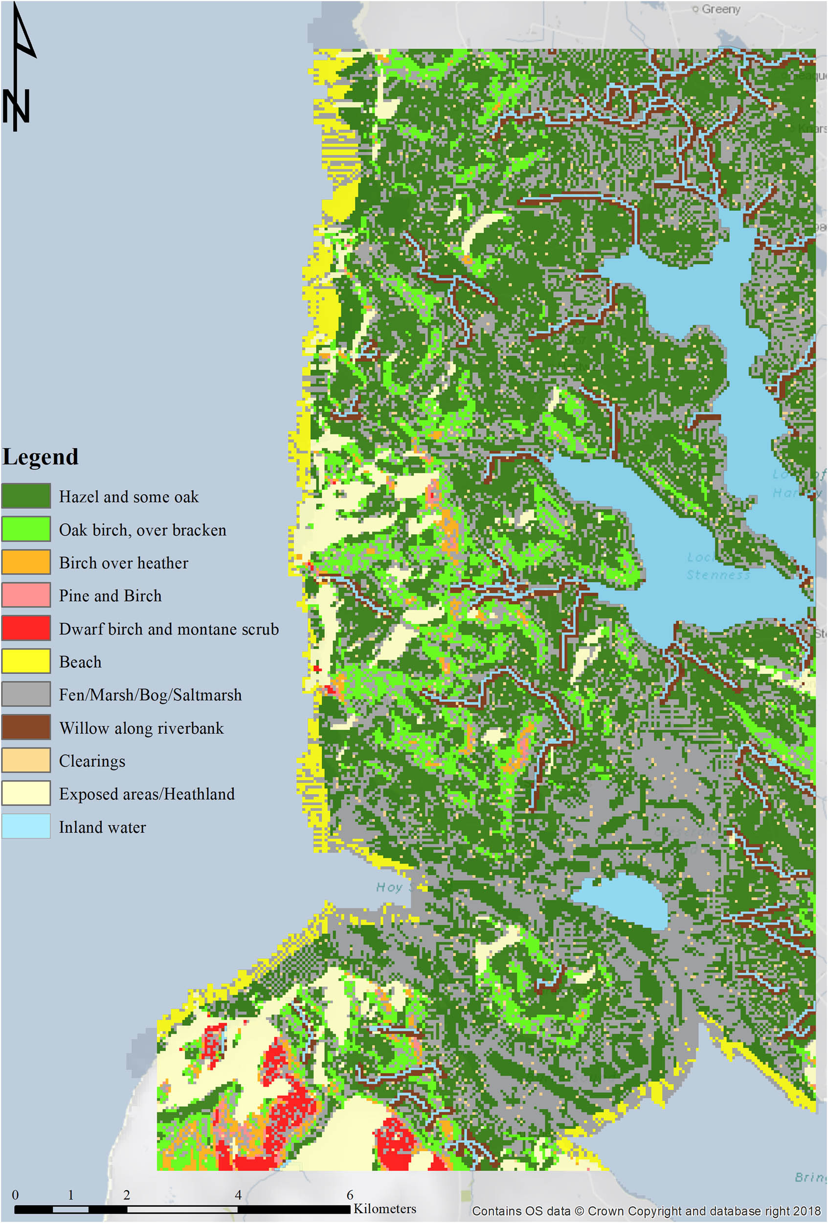
The final land mass was generated by integrating bathymetric and terrain data derivatives (Table 1) to recreate a digital terrain model to which detail could be added to synthesise land cover as a single layer. Data were processed using ArcMap 10.4.1. A 50 m2 cell resolution was used for all elements of this work to allow an effective visual inspection of terrain by an agent. In the absence of definitive vegetation data, this model simulates a layer of calibrated land cover based on a review of literature (for example: Davies, 2014; Farrell, 2009; Farrell et al., 2014; Timpany et al., 2013, 2014, 2015; Wilson, 2015) (Figure 2). The following types of land cover were included:
Woodland (various)
Clearings
Fen/marsh/bog/saltmarsh
Heathland
Beach
Waterways/lakes/sea.
Simplified table of land cover relating to movement speed (details of land cover speed estimation are held in Table S2, with full detail of factors summarised in Sucharyna Thomas, 2017)
| Land cover | Speed of movement |
|---|---|
| Steep slope open grassland | Slow |
| Peat bog | Slow |
| Hazel woodland | Intermediate |
| Open willow scrub | Fast |
| Level Open grassland | Fast |
| Beach | Fast |
Calibrated land cover.
7.1.1 Woodland
Post-glacial Orkney is assumed to have been fairly heavily wooded with hazel and, later, birch and willow becoming prolific, whereas oak and scots pine were also present (Farrell, 2009; Timpany et al., 2015). The following breakdown provided a baseline for woodland:
Slope foot (0–5°): hazel with some oak;
Lower slope (5–10°): hazel/birch with oak over bracken;
Mid slope (10–15°): birch over heather;
Upper-mid slope (15–20°): pine and birch;
Upper slope (20+°): dwarf birch and montane scrub.
Source: Wilson (2015).
Willow was treated separately, to delineate areas that housed dense willow succession. This required the establishment of a 75 m buffer around watercourses, to simulate the presence of complex willow woodland prior to the integration of hazel-dominant mixed woodland (Timpany et al., 2013, 2014).
7.1.2 Clearings
Anthropogenic clearance is not factored into the land cover to maintain the pristine environment appropriate to this study. However, naturally occurring clearings present as a result of ecological succession are included using a randomised raster with a mean and standard deviation parameter of 0 and 1, using a “Normal” distribution. Water is removed from consideration, so the clearings were only generated on land.
7.1.3 Wetlands
Moisture rich land-cover types are grouped as a single class, because they possess shared characteristics for the purpose of this study and act as a barrier to movement. This coverage will be based on a wetness index (WI) calculation:
A bilateral class split was used to emulate the level of Fen/Marsh/Bog/Saltmarsh present in the landscape during the Mesolithic.
7.1.4 Heathland
Exposed areas are often populated by heathland, represented here by using the hillshade tool, set to expose locations most heavily affected by the prevailing north-westerly wind.
7.1.5 Beach
Beach is created by using an assessment of the difference between the modern and Mesolithic coastlines and undertaking a visual inspection to identify the locations most likely to be beach. Beach is not necessarily a sandy coastline, but rather an assessment of a gentle approach to land from sea. It is classed as an open area. Areas such as that surrounding the Bay of Ireland were assessed as covered by vegetation.
7.1.6 Water
The modern extent of watercourses and lochs was rasterised and included, whereas the sea is corrected for the increased landmass of Orkney.
7.2 The Movement Resistance Surface
The physical reality of movement across any terrain is, all too often, overlooked or only loosely developed in ABM simulations. Given that landscape is not uniform, any exploratory group of people will encounter a variety of terrain and land-cover types, all of which can impact on speed and direction of travel. The model takes account of this by assigning difficulty values based on attributes such as vegetation, slope, and drainage (Tables 1 and 2) (for example Carver & Müller, 2014). This is known as the Movement Resistance Surface and it is this that gives the model its potential to analyse the human exploration of the landscape. This analysis is achieved by attributing a likely speed to each factorial input, varying from a fast base movement of 5 kph, and combining the inputs to calculate an aggregated operator function. Slope, ruggedness, exposure, and land cover were all regarded as relevant.
Showing the modelled base speed attributed to each land-cover type (full detail of factors are summarised in Sucharyna Thomas, 2017)
| Land-cover type | Hazel with the emergence of some Oak | Hazel/Birch with Oak over bracken | Birch over heather | Pine and Birch | Dwarf Birch and montane scrub | Beach | Fen/Marsh/Bog/Saltmarsh | Willow adjacent to watercourses | Clearings | Exposed/Heathland | Sea, Waterways, and Inland water |
|---|---|---|---|---|---|---|---|---|---|---|---|
| Speed (kph) | 3 | 2.9 | 2.75 | 2.6 | 2.5 | 5 | 1.5 | 3.5 | 5 | 4 | N/A |
7.3 The Cost Assessment Tool
To reflect the movement potential of any section of landscape for a hypothetical human community, it is necessary to calculate mobility across spatial aggregations of accumulated resistance surfaces and create individual pathways. This was addressed by creating the Cost Assessment Tool, a behavioural algorithm to compute probable ground traversed by an agent within the model (Sucharyna Thomas, 2017). The Cost Assessment Tool models the landscape interpretation potential of simulated agents by assuming that at 50 m distance the Mesolithic agent will be able to make a judgement call regarding the traversal difficulty of the immediately surrounding area by considering the Movement Resistance Surface values of adjacent cells (a “D8” visual inspection, requiring the agent to review adjacent cells in the cardinal and ordinal directions).
8 The Agent-Based Model
The modelling programme NetLogo (https://ccl.northwestern.edu/netlogo/), an open-source integrated development environment, was used to create the ABM. The model code is available at: https://tinyurl.com/MesoSimulation. NetLogo maintains a cellular in silico modelling environment, enabling a cell-to-patch ratio of 1:1 with the input raster. Each cell represents 50 m2, allowing the precise representation of a large geographical area. For the purpose of this research, it is assumed that a small mobile party embark on an exploratory journey from an arrival point around the Bay of Ireland. Deploying the Movement Resistance Surface within NetLogo permits programmed agents to assess their environment and move.
Mobility modelling is often abstracted from the experience of physical movement, leading with codified notions of origin and destination to determine a connective route. In such exercises, agency may be unnecessarily abstracted or modified by the engendered parameters: agents may be inserted into an environment with full knowledge of the location of resources, but lacking geographical information; or terrain surfaces are simplified and play little role in determining movement.
Hitherto, Least-Cost Pathways (LCP) have proved a popular tool in mobility studies, but this work regards them as limited, as a result of their predetermined structure of destination/origin, as well as the potential for a cognitive dissonance in the agent where the LCP indicates nonsensical pathing. Instead, the production of “natural corridors” within the landscape is preferable and regarded as significant, providing communicable, repeatable, and useful routeways for journeys. This is supported by the work of the Southern Hebrides Mesolithic Project, which highlighted the potential for sites to be located on routeways, even when lithic production and resources were the primary drivers for site location (Mithen, 2000). The investigation of natural corridors allows for inquiry to proceed beyond a static understanding of the resource environment or sites related to processing and other activities. Echoing Ingold (2011), it helps to address a more dynamic analysis of human existence across space by understanding movement through it. For this reason, the agents in this study were not allocated any specific destination, rather they were programmed to move across the landscape and expend the least effort, in an attempt to understand where the natural channels of movement might occur.
8.1 Creating Mesolithic Agents – The Rules of the Model
One of the central aims of the project was to simulate the movement dynamics of a hypothetical group of individuals exploring from an acknowledged entry point of Mesolithic Orkney, c. 8000 BC. To build a set of rules relating to the Mesolithic lifestyle and decision-making processes, a body of literature was explored, including traditional archaeological theory, dominant Mesolithic behavioural work such as OFT, and current modelling interpretations of hunter-gatherer societies (for example: Bishop et al., 2015; Grøn, 2017, 2012; Ingold, 2000; Lake, 2000; MacFayden, 2011).
With regard to the movement dynamics, agents were programmed to arrive at the selected entry point and assess the environment around them. The behavioural objective of the agent upon leaving the entry point is to react and move through the landscape using a projected visual inspection range of 50 m. This created an attempt to mimic potential explorative movement, while removing the constraint of a fixed destination. It allows for a “natural” movement flow from which workable corridors can emerge. At this stage in the research, the layers representing possible resource attributions of different cells have not been added. Each iteration of the model represents a single agent decision. Agent behaviour is codified within the Cost Assessment Tool and is therefore influenced by the type of land encountered and ease of access into the neighbouring landscape (Figure 3a). Figure 3b illustrates the operation of these agent rules. The agent progresses using this “least-cost” decision chain, moving to cells that have not been visited before and prioritising them on the basis of perceived accessibility and movement potential. The agent “memory” keeps a log of all visited cells, with an emphasis on accessing virgin land. Where all cells surrounding the agent have been visited, the agent will move randomly to find undiscovered areas before continuing to forge a path. In this way, individual agents start to build knowledge of their environment.
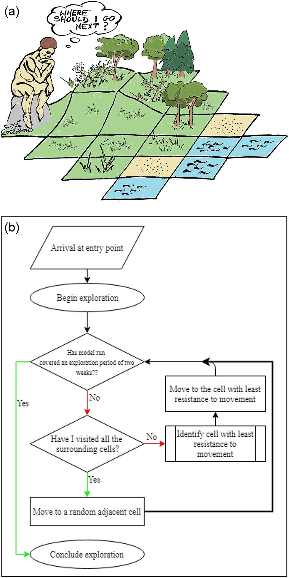
(a) An agent on a cell of land considering where to explore next; (b) flowchart showing the decision-making of an individual agent.
To optimise the model run time realistically, the simulation portrays a broad approximation of a daily exploration routine of seven hours per day, continuing each day from the stopping point, over a two-week period.
8.2 Running the Agent-Based Model
With the Cost Assessment Tool, the Movement Resistance Surface can be used to determine the role of the environment in influencing the speed of an agent’s movement across the landscape at any one point as follows:
Hazel woodland with emergence of oak and slope interval of 0–5° move at 3 kph;
Clear/natural opening on level ground move at 5 kph;
Fen/bog/marsh/salt marsh move at 1.5 kph.
(See Table 2 for additional information about different landscape types).
The overview, design concepts, and details protocol (Grimm et al., 2006) can be found in the supplementary materials and describes the ABM. Initial testing of the model ensured that the simulated agent was able to move according to the established rules – the agent did not try to traverse impassable sections of landscape and overall maintained forward progress without returning to previously visited cells.
In the pilot study, a total of 35 separate runs were undertaken, five for each entry point. These exploratory pathways were plotted across the site suitability map. This permitted the observation of site visitation, a crude identification of densely accessed natural corridors in the landscape, and the creation of basic inferences regarding the type of land explored for the establishment of sites.
8.3 Site Suitability
Six weighted input factors were combined to develop a layer related to the identification of site suitability. The individual elements of each factor were selected according to published research and combined in a similar manner to the landscape provisions of the Norwegian and Danish models:
Drainage – the assumption that dry land is preferable to walk across compared with waterlogged land;
Cost Surface – camp sites are unlikely to be established in difficult to access areas;
Exposure – the assumption that prevailing winds played an important role in site selection;
Inland Water – the time required to access fresh water;
Haul Out – existence of safe and accessible harbours for hide craft;
Aspect – preference was allocated to south-facing locations.
Table S2 provides details of each factor and their division into suitability categories. This is set to a scale of 1–5, where 1 is highly suitable and 5 is unsuitable for site establishment.
8.3.1 Model Weightings
Flexibility is embedded into the model using a system of weightings. Weighted inputs (Table 3) are combined to produce a suitability score for each cell (Carver & Müller, 2014, pp. 6–7). These factor weights are user-defined, derived from the apparent weightings compiled through a non-systematic review of case studies and literature relating to hunter-gatherer lifestyles (see Sucharyna Thomas, 2017 for review). Based on this analysis, the site suitability map shown in Figure 4 was generated.
Weights assigned to each variable in the predictive model
| Variable | Model weight |
|---|---|
| Drainage | 0.275 |
| Cost surface | 0.275 |
| Exposure | 0.2 |
| Distance to inland/fresh water | 0.1 |
| Distance to a haul out | 0.1 |
| South facing | 0.05 |

Site suitability prediction map, depicting known sites and the modelled entry points.
9 Results
9.1 Running the Model
After completion of the initial series of model runs, a total of 35 potential pathways had been generated across the landscape (Figure 5 shows a sample pathway). Assessment of pathway characteristics indicated that, in general, the model principals had worked to identify feasible routes. The model was designed to focus on terrestrial movement, using bodies of water as a boundary. Unsuitable areas were avoided by the agents, and the southern area of high elevation and slope largely acted as a boundary to movement. On occasion, an agent became stuck and had to resort to traversing these “difficult” areas to find unexplored ground.
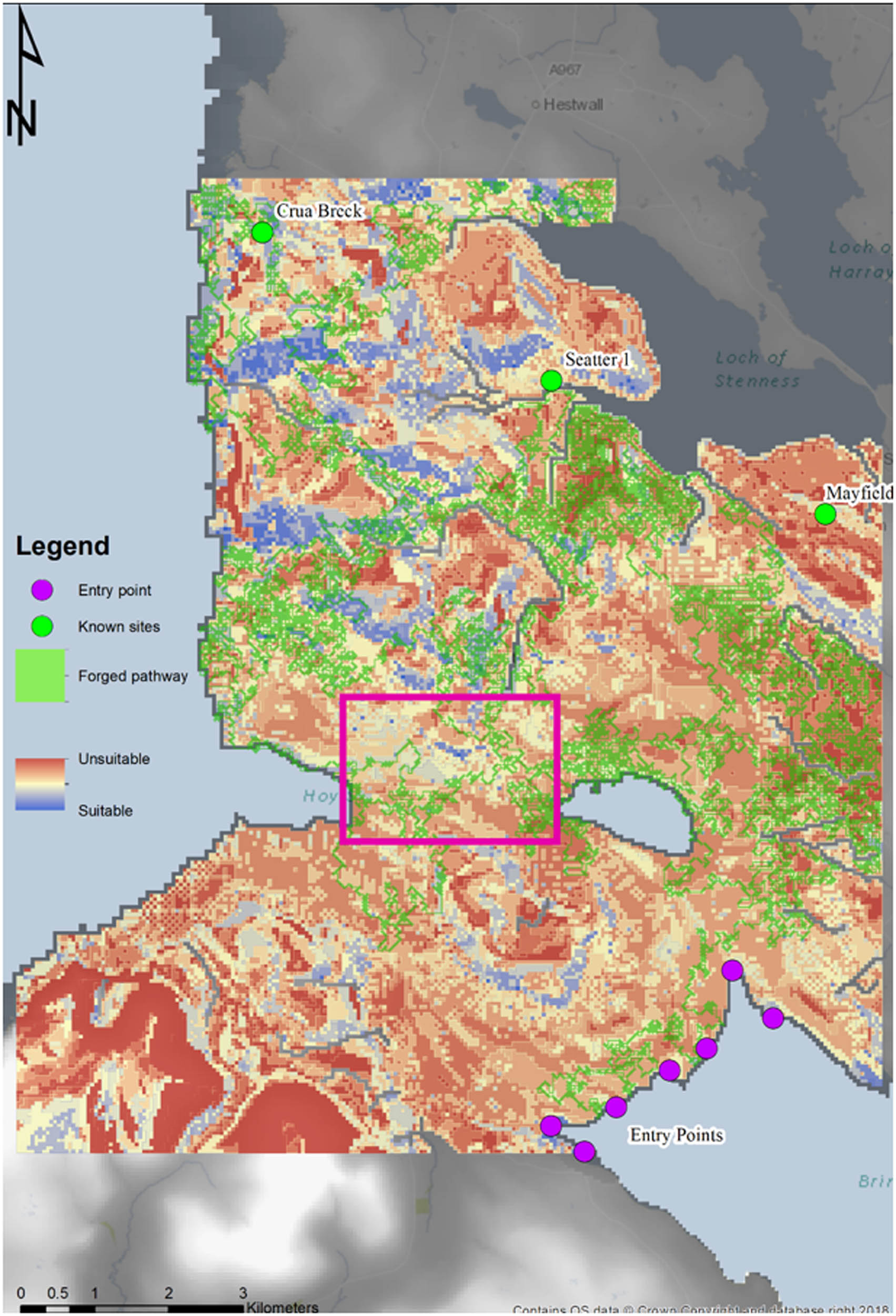
An example of the ABM generated pathway (green) on top of the settlement suitability prediction map. Potential movement corridor highlighted in pink.
9.2 Current Limitations of the Model
9.2.1 Data Sourcing
Archaeological modelling is reliant on a corpus of pre-existing material that does not always translate to the digital space which seeks to make the most effective representation of that knowledge in silico. It is often the case, as here, that the further one goes back in time, the greater the level of uncertainty regarding data and its interpretation. Proxies are used here to provide “information” relating to land cover and physical processes, as well as the terrain itself, which has been further abstracted to reflect, in part, the Mesolithic topography (Table S1 shows the terrain data used).
9.2.2 Land-Cover Data
In the absence of definitive statistical reconstructions, environmental and landscape attributes have been modelled from proxy data, leading to a necessary abstraction from reality.
9.2.3 Limited Scope
As a pilot study, this model incorporates a series of reductive processes designed to facilitate the early workings and establish a baseline to progress research. This means that the ABM is still preliminary, although some conclusions may be drawn. It may, in a coarse manner, already be considered to highlight areas that are inhibitory to movement.
9.2.4 Lack of Scale
A more detailed assessment of the appropriate scale for the research questions is required before progressing the research.
9.2.5 Model Testing
The project did not, at this stage, include a robust model testing protocol to assess accuracy and uncertainty. It does, however, provide a reasonable baseline platform from which protocols may be developed and integrated in future.
9.2.6 Sensitivity Analysis
Analysis of the sensitivity of the model has not, so far, been explored. Model weights were not assigned to the individual input factors through statistical analysis, but rather by deriving an “appropriate” weighting drawn from the literature review. This is currently being addressed through advanced testing of the model. It should be remembered that the research is not intended to come up with definitive predictions. The weightings of the individual factors reflect the emphasis of current research and will be subject to change as work develops.
9.2.7 Uncertainty
Following from the above, there is deep uncertainty within the models generated here, stemming from the biases of both pre-existing and current research. These include the simplistic “environmentally determinist” perspective used to set up the model (in the absence, to date, of opportunity for refinement) and the lack of robust validation and testing protocols. However, the pilot study is designed to introduce a novel investigative approach and intended to be a platform for the development of usable “early-stage” tools. These can be combined with traditional approaches, by researchers and the development/commercial sector alike, to work towards improved understanding and management of archaeology.
10 Discussion
The successful application of preliminary ABM relating to Mesolithic Orkney presented here is not intended to illustrate a true pattern of settlement and movement, nor does it seek to prioritise landscape or environmental factors as the chief determinants of human behaviour. Rather, it is used to illustrate the importance of heightened landscape awareness within behavioural studies relating to early prehistory. Deployment of the model lifts the role of landscape within hunter-gatherer studies beyond the traditionally assumed position of a passive background. It facilitates the development of a baseline scalable model of the physical environment that may be adapted easily for wider use in other locations. By establishing an appreciation of the baseline complexity of the data on physical environment and the dynamic nature of its relationship with human groups, it is hoped to introduce more interactive investigations, particularly within mobility studies. Further drivers, including complex social, political, economic, or religious elements, can all be added to the analysis with time.
In addition to facilitating a deeper exploration of mobility to include a more interactive relationship between human groups and the land within which they lived, the model offers a simple predictive tool that can be refined with time and used for both research and management. Within the study area, the three known Mesolithic sites were all located within cells assigned moderate suitability scores for site location and they lie close to the generated pathways (Figure 5). This might infer that the model was able to predict the potential for Mesolithic activity with some reliability. However, the study is subject to a common uncertainty principle in archaeological modelling – the restrictive nature of the current archaeological record limits validation (Romanowska, 2015, p. 171). The paucity of Mesolithic material within the study area not only provided an impetus to the use of modelling as an archaeological aide, it also restricts the ability to verify the predictive potential of the model. Recent work by Wickham-Jones et al. (2021) has shown the effectiveness of a targeted survey and test pitting programme to identify Late upper Palaeolithic and Mesolithic remains. This characterises the logical sequence from expert knowledge to computational modelling to field investigation, wherein modelling can target resource for effective deployment in the field.
Although the study area lacks known Mesolithic sites, the authors suggest that archaeological material is likely to await discovery here.
Although the simulated pathways remain untested and preliminary, they too are interesting, suggesting as they do the presence of a persistent movement corridor through the area between Stromness Harbour and the western Hoy Sound (Figure 5), highlighting the potential of this area (now underwater) for Mesolithic activity and related archaeological material.
Within the application, some elements are worthy of further discussion:
10.1 Land Cover
Further investigation into the efficacy and utility of proxies, rectification methods, and scale of analysis is necessary. Data to be integrated include sources such as palaeoenvironmental cores.
10.2 Movement Resistive Surface
The model demonstrated the applicability of the Movement Resistive Surface as a tool to be integrated into the ABM. Although model testing protocols will undoubtedly require some alteration to the generated layers, a rigorous review of movement behaviour and scale will help to refine the decision-making process. Elements such as the incorporation of visibility analysis can further contextualise the agent in the landscape.
10.3 Suitability Map
Mesolithic Orkney was chosen for this particular case study because, despite the paucity of archaeological data, the nature of the landscape and environment indicates considerable potential for suitable activity. In this case, it was possible to collate a model of site suitability rapidly, based upon an “expert” understanding of the context. The possibility of similar application elsewhere means that the model offers great promise for wider deployment even in areas where the archaeology is poorly represented.
10.4 Research and Management
The traditional polarisation of archaeological analysis between research and rescue outcomes has been somewhat eroded in recent years with increasing refinement of the value of academic understanding to successful management. Although the application of the ABM presented here has clear research value, it is also the intention of the authors to highlight its potential as a management tool. One emerging trend in development-led archaeology has been the use of a presence/absence approach to model “risk” relating to the likelihood that archaeological remains exist on a proposed site. A model such as this offers the capability to create a set of landscape rules applicable at varying scales and suitable to facilitate rapid assessment of the archaeological potential within any given area.
11 Conclusions
This pilot study was necessarily reductive, using a limited range of lower resolution data, constrained movement behaviour, and a focus on exploratory mobility. Future developments will target the complexities of the physical environment as a foundational driver, as well as layering further input factors, including:
The refinement of the movement dynamics and cost assessment tools to heighten the representation of human cognition and development of landscape understanding with time;
The incorporation of varying scales of environmental data building layers through time with each model run;
The addition of social factors to represent the interplay between elements of a growing population;
The integration of information relevant to site typology to enhance and test the site prediction models.
Although the rules created for this particular application of the model remain open to adjustment, the code allows it to be modified for other geographical areas and chronological periods. This is not only a research tool, it also has great potential to inform the archaeological management process. Although any modelling should not be considered as a replacement for empirical data, the identification of areas of interest can be used to inform developers early in a planning exercise and with a view to empirical testing. In this way, it becomes possible to predict areas where the archaeology is likely to be at risk and provide a sophisticated planning aid that takes account of the complexities of human behaviour and local idiosyncrasies. Management processes are lifted above a reliance on static data to create graded suitability scores that could subsequently be converted into a “traffic light” system. Given the highly specialist skillsets required for successful management, the present authors would see this as a useful long-term aspiration.
Acknowledgments
This research was undertaken as a Masters project at the University of Leeds, UK. Edina Digimap, Marine Scotland, and the United Kingdom Hydrographic Office (UKHO) are acknowledged for help with data acquisition. Alison Heppenstall is funded by an ESRC-Alan Turing Fellowship. A special thanks is extended to Karolina Werens for Figure 3a.
-
Conflict of interest: The authors declare that there is no conflict of interest.
References
Benjamin, J. (2010). Submerged prehistoric landscapes and underwater site discovery: Reevaluating the “Danish Model” for international practice. Journal of Island and Coastal Archaeology, 5, 253–270. doi: 10.1080/15564894.2010.506623.Search in Google Scholar
Bishop, R. R., Church, M. J., Rowley-Conwy, P. A. (2015). Firewood, food and human niche construction: the potential role of Mesolithic hunter-gatherers in actively structuring Scotland’s woodlands. Quaternary Science Reviews, 108, 51–75. doi: 10.1016/j.quascirev.2014.11.004.Search in Google Scholar
Carver, S., & Müller, C. (2014). Wildness study in wales. Wildland Research Institute. https://wildlandresearch.org/wp-content/uploads/sites/39/2016/10/Report_WildMappingWales-v.2-Feb-2015.pdf.Search in Google Scholar
Cegielski, W. H., & Rogers, D. (2016). Rethinking the role of agent-based modeling in archaeology. Journal of Anthropological Archaeology, 41, 283–298. doi: 10.1016/j.jaa.2016.01.009.Search in Google Scholar
Ch’ng, E. (2012). Macro and micro environment for diversity of behaviour in artificial life simulation. In: The 6th International Conference on Soft Computing and Intelligent Systems, and The 13th International Symposium on Advanced Intelligence Systems. 2012 (pp. 883–889). IEEE. doi: 10.1109/SCIS-ISIS.2012.6505014.Search in Google Scholar
Ch’ng, E. (2013). Model resolution in complex systems simulation: Agent preferences, behaviour dynamics and n-tiered networks. Simulation, 89(5), 635–659. doi: 10.1177/0037549712470582.Search in Google Scholar
Ch’ng, E., Gaffney, V., & Hakvoort, G. (2014). Stigmergy in comparative settlement choice and palaeoenvironment simulation. Complexity, 21(3), 59–73. doi: 10.1002/cplx.21616.Search in Google Scholar
Crabtree, S. A., Bocinsky, R. K., Hooper, P. L., Ryan, S. C., & Kohler, T. A. (2017). How to make a polity (in the central Mesa Verde region). American Antiquity, 82(1), 71–95. doi: 10.1017/aaq.2016.18.Search in Google Scholar
Crema, E. (2014). A simulation model of Fission-Fusion dynamics and long-term settlement change. Journal of Archaeological Method and Theory, 21(2), 385–404. doi: 10.1007/s10816-013-9185-4.Search in Google Scholar
Crawford, R. M. M. (2000) Land plants in an oceanic environment. In R. J. Berry (Ed.), Orkney nature (pp. 49–79). London: Academic Press.Search in Google Scholar
Crooks, A. T., Malleson, N. S., Manley, E., & Heppenstall, A. J. (2019). Agent-based modelling and geographical information systems: A practical primer. London: Sage.10.4135/9781529793543Search in Google Scholar
Davies, B. J. (2014). Turtles in space! Integrating GIS and NetLogo. https://simulatingcomplexity.wordpress.com/2014/08/20/turtles-in-space-integrating-gis-and-netlogo/.Search in Google Scholar
Davies, B., Romanowska, I., Harris, K., & Crabtree, S. A. (2019). Combining geographic information systems and agent-based models in archaeology: Part 2 of 3. Advances in Archaeological Practice, 7(2), 185–193. doi: 10.1017/aap.2019.5.Search in Google Scholar
Dean, J. S., Gumerman, G. J., Epstein, J. M., Axtell, R. L., Swedlund, A. C., Parker, M. T., & McCarroll, S. (2000). Understanding Anasazi culture change through agent-based modelling. In T. A. Kohler & G. J. Gummerman (Eds.), Dynamics in human and primate societies (pp. 179–205). Oxford: Oxford University Press.10.1093/oso/9780195131673.003.0013Search in Google Scholar
Dingwall, K., Ginnever, M., Tipping, R., van Wessel, J., & Wilson, D. (2019). The land was forever. Oxford: Oxbow Books.Search in Google Scholar
Edmonds, M., Anderson-Whymark, H., Clarke, A., & Thomas, A. (2016). Working stone. http://www.orkneystonetools.org.uk/about.Search in Google Scholar
Farrell, M. (2009). The environmental context of later prehistoric human activity in Orkney, Scotland (Ph.D. dissertation). The University of Hull, Hull.Search in Google Scholar
Farrell, M., Bunting, J., Lee, D. H. J., & Thomas, A. (2014). Neolithic settlement at the woodland”s edge: Palynological data and timber architecture in Orkney, Scotland. Journal of Archaeological Science, 51, 225–236. doi: 10.1016/j.jas.2012.05.042.Search in Google Scholar
Fischer, A. (2007). Coastal fishing in stone-age Denmark. In N. Milner, O. E. Craig, & G. N. Bailey (Eds.), Shell Middens in Atlantic Europe (pp. 54–69). Oxford: Oxbow Books.Search in Google Scholar
Fitch, S., Thompson, K., & Gaffney, V. (2005). Late Pleistocene and Holocene depositional systems and the palaeography of the Dogger Bank, North Sea. Quaternary Research, 64(2), 185–196.10.1016/j.yqres.2005.03.007Search in Google Scholar
Fitch, S. Gaffney, V., & Thompson, K. (2007). In sight of Doggerland: From speculative survey to landscape exploration. Internet Archaeology, 22. doi: 10.11141/ia.22.3.Search in Google Scholar
Fitch, S., Gaffney, V., Gearey, B., & Ramsey, E. (2011). Between the lines – enhancing methodologies for the exploration of extensive, inundated palaeolandscapes (Remote sensing for Archaeological Heritage Management, Edition: Occasional Papers number 5), EAC. pp. 173–204).Search in Google Scholar
Fuglestvedt, I. (2012). The pioneer condition on the Scandinavian Peninsula: The last frontier of a “Palaeolithic Way” in Europe. Norwegian Archaeological Review, 45(1), 1–29. doi: 10.1080/00293652.2012.669998.Search in Google Scholar
Gammack, D. (2015). Using NetLogo as a tool to encourage scientific thinking across disciplines. Journal of Teaching and Learning with Technology, 4(1), 22–39. doi: 10.14434/jotlt.v4n1.12946.Search in Google Scholar
Gravel-Miguel, C., & Wren, C. D. (2018). Agent-based least-cost path analysis and the diffusion of Cantabrian lower Magdalenian engraved scapulae. Journal of Archaeological Science, 99, 1–9. doi: 10.1016/j.jas.2018.08.014.Search in Google Scholar
Grimm, V., Berger, U., Bastiansen, F., Eliassen, S., Ginot, V., Giske, J., … DeAngelis, D. L. (2006). A standard protocol for describing individual-based and agent-based models. Ecological Modelling, 198(1), 115–126. doi: 10.1016/j.ecolmodel.2006.04.023.Search in Google Scholar
Groß, D., Zander, A., Boethius, A., Dreibrodt, S., Grøn, O., Hansson, A., … Nilsson, B. (2018). People, lakes and seashores: Studies from the Baltic Sea basin and adjacent areas in the Early and Mid-Holocene. Quaternary Science Reviews, 185, 27–40. doi: 10.1016/j.quascirev.2018.01.021.Search in Google Scholar
Grøn, O. (2018). Some problems with modelling the positions of prehistoric hunter-gatherer settlements on the basis of landscape topography. Journal of archaeological Science: Reports, 20, 192–199. doi: 101.1016/j.jasrep.2018.04.034.Search in Google Scholar
Grøn, O. (2017). Optimal foraging or not? An Evenk example of resource exploitation. Stratum Plus, 1, 319–328.Search in Google Scholar
Grøn, O. (2012). Our grandfather sent the elk – some problems for hunter-gatherer predictive model. Quartär, 59, 1–14. doi: 10.7485/QU59_8.Search in Google Scholar
Hardy, K., & Wickham-Jones, C. R. (2009). Mesolithic and later sites around the Inner Sound, Scotland: The work of the Scotland”s First Settlers project 1998–2004. Scottish Archaeological Internet Reports 31. www.sair.org.uk.10.9750/issn.2056-7421.2009.31.1-753Search in Google Scholar
Herzog, I. (2014). Least-cost paths – Some methodological issues. Internet Archaeology, 36. doi: 10.11141/ia.36.5.Search in Google Scholar
Ingold, T. (1993). The temporality of the landscape. World Archaeology, 25(2), 152–174. doi: 10.1080/00438243.1993.9980235.Search in Google Scholar
Ingold, T. (2000). The Perception of the Environment: Essays in livelihood, dwelling and skill. London: Routledge.Search in Google Scholar
Ingold, T. (2011). Being Alive: Essays on Movement, Knowledge and Description (1st ed.). Routledge. doi: 10.4324/9780203818336.Search in Google Scholar
Kador, T. (2007). Where are we going? Movement and mobility in Mesolithic research. Internet Archaeology, 22. doi: 10.11141/ia.22.2.Search in Google Scholar
Kohler, T. A., & van der Leeuw, S. E. (2009). Introduction: Historical socionatural systems and models. In T. A. Kohler & S. E. van der Leeuw (Eds.), The model-based archaeology of socionatural systems (pp. 1–12). Canada: School for Advanced Research.Search in Google Scholar
Kohler, T. A., Johnson, D., Varien, M., Ortman, S., Reynolds, R., Kobti, Z., … Yap, L. (2009). Settlement ecodynamics in prehispanic Central Mesa Verde region. In T. A. Kohler & S. E. van der Leeuw (Eds.), The model-based archaeology of socionatural systems (pp. 61–104). Canada: School for Advanced Research.Search in Google Scholar
Kohler, T. A., Bocinsky, R., Cockburn, D., Crabtree, S., Varien, M., Kolm, K. E., … Kobti, Z. (2012). Modelling prehispanic Pueblo societies in their ecosystems. Ecological Modelling, 241, 30–41. doi: 10.1016/j.ecolmodel.2012.01.002.Search in Google Scholar
Lake, M. W. (2000). MAGICAL computer simulation of Mesolithic foraging. In T. A. Kohler & G. J. Gummerman (Eds.), Dynamics in human and primate societies (pp. 107–144). Oxford: Oxford University Press.10.1093/oso/9780195131673.003.0011Search in Google Scholar
Lake, M. W. (2014). Trends in archaeological simulation. Journal of Archaeological Method and Theory, 21(2), 256–287. doi: 10.1007/s10816-013-9188-1.Search in Google Scholar
Llobera, M. (2000). Understanding movement: A pilot model towards the sociology of movement. In G. Lock (Ed.), Beyond the map: Archaeology and spatial technologies. Oxford: IOS Press.Search in Google Scholar
Madella, M., Rondelli, B., Lancelotti, C., Balbo, A., Zurro, D., Rubio-Campillo, X., & Stride, S. (2014). Introduction to simulating the past. Journal of Archaeological Method and Theory, 21(2), 251–257. doi: 10.1007/s10816-014-9209-8.Search in Google Scholar
McFayden, L. (2011). Temporary spaces in the Mesolithic and Neolithic: Understanding landscapes. In Pollard, J. Prehistoric Britain (pp. 121–134). Oxford: Blackwell Publishing.Search in Google Scholar
Milner, N., Mithen, S. (2009). Hunter-gatherers of the Mesolithic. In Hunter, J., Ralston, I. (Eds.), The Archaeology of Britain: An introduction from earliest times to the twenty-first century (pp. 53–77). Oxford: Routledge.Search in Google Scholar
Mithen, S., & Reed, M. (2002). Stepping out: A computer simulation of hominid dispersal from Africa. Journal of Human Evolution, 43(4), 433–462. doi: 10.1006/jhev.2002.0584.Search in Google Scholar
Mithen, S. (2000). Hunter-gatherer landscape archaeology: The Southern Hebrides Mesolithic project, 1988–1998. Cambridge: McDonald Institute for Archaeological Research.Search in Google Scholar
Nikitas, P., & Nikita, E. (2005). A study of hominin dispersal out of Africa using computer simulations. Journal of Human Evolution, 49(5), 602–617. doi: 10.1016/j.jhevol.2005.07.001.Search in Google Scholar
Oram, R.. (1997). Scottish Prehistory. Edinburgh: Berlin.Search in Google Scholar
Pearson, M. P., Pollard, J., Richards, C., Thomas, J., Tilley, C., & Welham, K. (2008). The Stonehenge riverside project: Exploring the Neolithic landscape of Stonehenge. Documenta Praehistorica, 35, 153–166.10.4312/dp.35.11Search in Google Scholar
Perry, G. L. W., & O’Sullivan, D. (2018). Identifying narrative descriptions in agent-based models representing past human-environment interaction. Journal of Archaeological Method and Theory, 25, 795–817. doi: 10.1007/s10816-017-9355-x.Search in Google Scholar
Renfrew, C. (1985). The Prehistory of Orkney. Edinburgh: Edinburgh University Press.Search in Google Scholar
Robertson, A., Lochrie, J., Timpany, S., Bailey, L., Mynett, A., Shillito, L.-M., & Smith, C. (2014). Built to last: Mesolithic and Neolithic settlement at two sites beside the Forth estuary, Scotland. Proceedings of the Society of Antiquaries of Scotland, 143, 73–136.10.9750/PSAS.143.73.136Search in Google Scholar
Romanowska, I. (2015). So you think you can model? A guide to building and evaluating archaeological simulation models of dispersals. Human Biology, 87(3), 169–192. doi: 10.13110/humanbiology.87.3.0169.Search in Google Scholar
Romanowska, I., Gamble, C., Bullock, S., & Sturt, F. (2017). Dispersal and the movius line: Testing the effect of dispersal on population density through simulation. Quaternary International, 431, 53–63. doi: 10.1016/j.quaint.2016.01.016.Search in Google Scholar
Rouly, O. (2009). In search of the roots of social complexity. Fairfax, Virginia: George Mason University. doi: 10.13140/2.1.4263.7609.Search in Google Scholar
Rouly, O. (2015). At the root of sociality: Working towards emergent, permanent, social affines, In P. Andrews, L. Caves, R. Doursat, S. Hickinbotham, F. Polack, S. Stepney, … J. Timmis (Eds.), Proceedings of the European Conference on Artificial Life 2015 (pp. 82–89). Massachusetts: MIT Press.10.7551/978-0-262-33027-5-ch022Search in Google Scholar
Rouly, O., & Crooks, A. (2010). Abstract. A prototype, multi-agent system for the study of the peopling of the Western Hemisphere. Proceedings of the Computational Social Science Society 2010 Conference. Tempe, Arizona, USA: Arizona State University. 4–6 November, 2010.Search in Google Scholar
Saville, A. (2000). Orkney and Scotland before the Neolithic period. In A. Ritchie (Ed.), Neolithic Europe in its European Context (pp. 91–100). Cambridge: Macdonald Institute Monograph.Search in Google Scholar
(ScARF) Saville, A., & Wickham-Jones, C. R. (2012). Palaeolithic and Mesolithic Panel Report. Edinburgh: Society of Antiquaries of Scotland, Scottish Archaeological Research Framework. http://tinyurl.com/d86dgfq.Search in Google Scholar
Schmidt, B. (2002). The modelling of human behaviour: The pecs reference model. In Proceedings 14th European Simulation Symposium. Dresden, Germany.Search in Google Scholar
Schmitt, L., Larsson, S., Schrum, C., Alekseeva, I., Tomczak, M., & Svedhage, K. (2006). Why they Came, The colonization of the coast of western Sweden and its environmental context at the end of the last glaciation. Oxford Journal of Archaeology, 25(1), 1–28.10.1111/j.1468-0092.2006.00246.xSearch in Google Scholar
Spikins, P., & Engen, M. (2004). Putting predictive models underwater, challenges new perspectives and potential of gis based predictive models in submerged areas. http://proceedings.caaconference.org/files/2004/51_Spikins_Engen_CAA_2004.pdf.Search in Google Scholar
Stanton, T. W. (2004). Concepts of determinism and free will in archaeology. American Anthropology, 38, 29–83.Search in Google Scholar
Sucharyna Thomas, L. (2017). Mesolithic settlement prediction and emergent movement dynamics: A predictive study of mobility across a complex Orcadian landscape. (Unpublished masters dissertation). University of Leeds, Leeds, England.Search in Google Scholar
Timpany, S., Crone, A., Hamilton, D. (2013). A stratigraphic, palaeoecological and dendrochronological investigation of a prehistoric oak “plank” and intertidal peats, Bay of Ireland, West Mainland, Orkney [Historic Scotland Project number: 53705, internal write up]. Scotland: Historic Scotland.Search in Google Scholar
Timpany, S., Littlewood, M., Pollard, E. (2014). Preliminary investigation of a “worked” wooden plank, submerged forest and intertidal peats at Cummi Ness, Bay of Ireland, Orkney. The current newsletter of the island and coast archaeology interest group, 2(1), 1–14.Search in Google Scholar
Timpany, S., Crone, A., & Hamilton, D. (2015). A stratigraphic, palaeoecological and dendrochronological investigationof a prehistoric oak “plank” and intertidal peats, Bay of Ireland, West Mainland, Orkney [Historic Scotland Project number: 53705, internal write up]. Scotland: Historic Scotland.Search in Google Scholar
Tipping, R., Bradley, R., Sanders, J., McCulloch, R. & Wilson, R. (2012). Moments of crisis: Climate change in Scottish prehistory. Society of Antiquaries of Scotland, 142, 9–25.10.9750/PSAS.142.9.25Search in Google Scholar
Tolan-Smith, C. (2008). Mesolithic Britain. In G. Bailey & P. Spikins (Eds.), Mesolithic Europe (pp. 132–157). Cambridge: Cambridge University Press.Search in Google Scholar
Verhagen, P., Nuninger, L., & Groenhuijzen, M. R. (2019). Modelling of pathways and movement networks in archaeology: An overview of current approaches. In P. Verhagen, J. Joyce, & M. Groenhuijzen (Eds.), Finding the limits of the limes. Computational Social Sciences. Cham: Springer. doi: 10.1007/978-3-030-04576-0_11.Search in Google Scholar
Verhagen, P. (2018). Spatial analysis in archaeology: Moving into new territories. In C. Siart, M. Forbriger, & O. Bubenzer (Eds). Digital geoarchaeology. Natural science in archaeology. Cham: Springer. doi: 10.1007/978-3-319-25316-9_2.Search in Google Scholar
Warren, G., Fraser, S., Clarke, A., Driscoll, K., Mitchell, W., Noble, G., … Wickham-Jones, C. R. (2018). Little house in the mountains? A small Mesolithic structure from the Cairngorm Mountains, Scotland. Journal of Archaeological Science: Reports. 18, 936–945. doi: 10.1016/j.jasrep.2017.11.021.Search in Google Scholar
Wickham-Jones, C. R. (2003). Searching for the first settlers of Orkney. http://www.orkneyjar.com/archaeology/dhl/papers/cwj/index.html.Search in Google Scholar
Wickham-Jones, C. R., & Firth, C. R. (2000). Mesolithic settlement of northern Scotland: First results of fieldwork in Caithness and Orkney. In R. Young (Ed.), Mesolithic lifeways: Current research from Britain and Ireland (pp. 119–32). Leiceste: University of Leicester (Leicester Archaeology Monographs No. 7).Search in Google Scholar
Wickham-Jones, C. R. (1990). Rhum: Mesolithic and later sites at Kinloch, excavations 1984–1986. Edinburgh: Society of Antiquaries of Scotland (Monograph series No. 7).10.9750/9781908332295Search in Google Scholar
Wickham-Jones, C. R., Bates, M., Bates, C. R., Dawson, S., & Kavanagh, E. (2016). People and Landscape at the heart of Neolithic Orkney. In I. Ostericher (Ed.), Archaeological review from Cambridge: Volume 31.2. Landscapes (pp. 26–47). Cambridge: Victoire Press Ltd.Search in Google Scholar
Wickham-Jones, C. R., Bates, C. R., Bates, M., & Dawson, S. (2017). The changing landscape of Prehistoric Orkney. In The ecology of Early Settlement in Northern Europe – Conditions for subsistence and survival – Per Persson (Vol. 1). United Kingdom: Equinox eBooks Publishing. doi: 10.1558/equinox.30926.Search in Google Scholar
Wickham-Jones, C., Bates, R., Cameron, A., Clarke, A., Collinson, D., Duthie, S., … Tipping, R. (2021). Prehistoric communities of the River Dee. Scottish Archaeological Internet Reports, 97, 1–196. doi: 10.9750/issn.2056-7421.2021.97.1-196.Search in Google Scholar
Wilensky, U., & Rand, W. (2015). An introduction to Agent-Based Modeling: Modeling natural, social, and engineered complex systems with NetLogo. Massachusetts: MIT Press.Search in Google Scholar
Wilson, S. (2015). The native woodlands of Scotland: Ecology, Conservation and Management. Edinburgh: Edinburgh University Press.10.1515/9780748692866Search in Google Scholar
Wren, C., Atwater, C., Hill, K., Janssen, M., De Vynck, J., & Marean, C. (2018). An agent-based approach to weighted decision making in the spatially and temporally variable South African Paleoscape. Proceedings of the 44th Computer Applications and Quantitative Methods in Archaeology Conference (CAA 2016). At: Oslo, Norway.10.31235/osf.io/fxmptSearch in Google Scholar
© 2022 Leo Sucharyna Thomas et al., published by De Gruyter
This work is licensed under the Creative Commons Attribution 4.0 International License.
Articles in the same Issue
- Editorial
- Editorial: Open Archaeology in Challenging Times
- Regular Articles
- Caves, Senses, and Ritual Flows in the Iberian Iron Age: The Territory of Edeta
- Tutankhamun’s Polychrome Wooden Shawabtis: Preliminary Investigation for Pigments and Gilding Characterization and Indirect Dating of Previous Restorations by the Combined Use of Imaging and Spectroscopic Techniques
- When TikTok Discovered the Human Remains Trade: A Case Study
- Nuraghi as Ritual Monuments in the Sardinian Bronze and Iron Ages (circa 1700–700 BC)
- A Pilot Study in Archaeological Metal Detector Geophysical Survey
- A Blocked-Out Capital from Berenike (Egyptian Red Sea Coast)
- The Winery in Context: The Workshop Complex at Ambarçay, Diyarbakır (SE Turkey)
- Tracing Maize History in Northern Iroquoia Through Radiocarbon Date Summed Probability Distributions
- Faunal Remains Associated with Human Cremations: The Chalcolithic Pits 16 and 40 from the Perdigões Ditched Enclosures (Reguengos de Monsaraz, Portugal)
- A Multi-Method Study of a Chalcolithic Kiln in the Bora Plain (Iraqi Kurdistan): The Evidence From Excavation, Micromorphological and Pyrotechnological Analyses
- Potters’ Mobility Contributed to the Emergence of the Bell Beaker Phenomenon in Third Millennium BCE Alpine Switzerland: A Diachronic Technology Study of Domestic and Funerary Traditions
- From Foragers to Fisher-Farmers: How the Neolithisation Process Affected Coastal Fisheries in Scandinavia
- Enigmatic Bones: A Few Archaeological, Bioanthropological, and Historical Considerations Regarding an Atypical Deposit of Skeletonized Human Remains Unearthed in Khirbat al-Dusaq (Southern Jordan)
- Who Was Buried at the Petit-Chasseur Site? The Contribution of Archaeometric Analyses of Final Neolithic and Bell Beaker Domestic Pottery to the Understanding of the Megalith-Erecting Society of the Upper Rhône Valley (Switzerland, 3300–2200 BC)
- Erratum
- Erratum to “Britain In or Out of Europe During the Late Mesolithic? A New Perspective of the Mesolithic–Neolithic Transition”
- Review Article
- Archaeological Practices and Societal Challenges
- Special Issue Published in Cooperation with Meso’2020 – Tenth International Conference on the Mesolithic in Europe, edited by Thomas Perrin, Benjamin Marquebielle, Sylvie Philibert, and Nicolas Valdeyron - Part I
- Animal Teeth and Mesolithic Society
- A Matter of Scale: Responses to Landscape Changes in the Oslo Fjord, Norway, in the Mesolithic
- Chipped Stone Assemblage of the Layer B of the Kamyana Mohyla 1 Site (South-Eastern Ukraine) and the Issue of Kukrek in the North Meotic Steppe Region
- Rediscovered Mesolithic Rock Art Collection from Kamyana Mohyla Complex in Eastern Ukraine
- Mesolithic Montology
- A Little Mystery, Mythology, and Romance: How the “Pigmy Flint” Got Its Name
- Preliminary Results and Research Perspectives on the Submerged Stone Age Sites in Storstrømmen, Denmark
- Techniques and Ideas. Zigzag Motif, Barbed Line, and Shaded Band in the Meso-Neolithic Bone Assemblage at Zamostje 2, Volga-Oka Region (Russia)
- Modelling Foraging Cultures According to Nature? An Old and Unfortunately Forgotten Anthropological Discussion
- Mesolithic and Chalcolithic Mandibular Morphology: Using Geometric Morphometrics to Reconstruct Incomplete Specimens and Analyse Morphology
- Britain In or Out of Europe During the Late Mesolithic? A New Perspective of the Mesolithic–Neolithic Transition
- Non-Spatial Data and Modelling Multiscale Systems in Archaeology
- Living in the Mountains. Late Mesolithic/Early Neolithic Settlement in Northwest Portugal: Rock Shelter 1 of Vale de Cerdeira (Vieira do Minho)
- Enculturating Coastal Environments in the Middle Mesolithic (8300–6300 cal BCE) – Site Variability, Human–Environment Relations, and Mobility Patterns in Northern Vestfold, SE-Norway
- Why Mesolithic Populations Started Eating Crabs on the European Atlantic Façade Only Over the Past 15 Years?
- “Ain’t No Mountain High Enough” – Mesolithic Colonisation Processes and Landscape Usage of the Inner-Alpine Region Kleinwalsertal (Prov. Vorarlberg, Western Austria)
- Mesolithic Freshwater Fishing: A Zooarchaeological Case Study
- Consumers, not Contributors? The Study of the Mesolithic and the Study of Hunter-Gatherers
- Fish Processing in the Iron Gates Region During the Transitional and Early Neolithic Period: An Integrated Approach
- Hunting for Hide. Investigating an Other-Than-Food Relationship Between Stone Age Hunters and Wild Animals in Northern Europe
- Changing the Perspective, Adapting the Scale: Macro- and Microlithic Technologies of the Early Mesolithic in the SW Iberian Peninsula
- Fallen and Lost into the Abyss? A Mesolithic Human Skull from Sima Hedionda IV (Casares, Málaga, Iberian Peninsula)
- Evolutionary Dynamics of Armatures in Southern France in the Late Mesolithic and Early Neolithic
- Combining Agent-Based Modelling and Geographical Information Systems to Create a New Approach for Modelling Movement Dynamics: A Case Study of Mesolithic Orkney
- Pioneer Archaeologists and the Influence of Their Scientific Relationships on Mesolithic Studies in North Iberia
- Neolithisation in the Northern French Alps: First Results of the Lithic Study of the Industries of La Grande Rivoire Rockshelter (Isère, France)
- Late Mesolithic Individuals of the Danube Iron Gates Origin on the Dnipro River Rapids (Ukraine)? Archaeological and Bioarchaeological Records
- Special Issue on THE EARLY NEOLITHIC OF EUROPE, edited by F. Borrell, I. Clemente, M. Cubas, J. J. Ibáñez, N. Mazzucco, A. Nieto-Espinet, M. Portillo, S. Valenzuela-Lamas, & X. Terradas - Part II
- Early Neolithic Large Blades from Crno Vrilo (Dalmatia, Croatia): Preliminary Techno-Functional Analysis
- The Neolithic Flint Quarry of Pozarrate (Treviño, Northern Spain)
- From Anatolia to Algarve: Assessing the Early Stages of Neolithisation Processes in Europe
- What is New in the Neolithic? – A Special Issue Dedicated to Lech Czerniak, edited by Joanna Pyzel, Katarzyna Inga Michalak & Marek Z. Barański
- What is New in the Neolithic? – Celebrating the Academic Achievements of Lech Czerniak in Honour of His 70th Birthday
- Do We Finally Know What the Neolithic Is?
- Intermarine Area Archaeology and its Contribution to Studies of Prehistoric Europe
- Households and Hamlets of the Brześć Kujawski Group
- Exploiting Sheep and Goats at the Late Lengyel Settlement in Racot 18
- Colonists and Natives. The Beginning of the Eneolithic in the Middle Warta Catchment. 4500–3500 BC
- Is It Just the Location? Visibility Analyses of the West Pomeranian Megaliths of the Funnel Beaker Culture
- An Integrated Zooarchaeological and Micromorphological Perspective on Midden Taphonomy at Late Neolithic Çatalhöyük
- The Neolithic Sequence of the Middle Dunajec River Basin (Polish Western Carpathians) and Its Peculiarities
- Great Transformation on a Microscale: The Targowisko Settlement Region
- Special Issue on Digital Methods and Typology, edited by Gianpiero Di Maida, Christian Horn & Stefanie Schaefer-Di Maida
- Digital Methods and Typology: New Horizons
- Critique of Lithic Reason
- Unsupervised Classification of Neolithic Pottery From the Northern Alpine Space Using t-SNE and HDBSCAN
- A Boat Is a Boat Is a Boat…Unless It Is a Horse – Rethinking the Role of Typology
- Quantifying Patterns in Mortuary Practices: An Application of Factor Analysis and Cluster Analysis to Data From the Taosi Site, China
- Reexamining Ceramic Standardization During Agricultural Transition: A Geometric Morphometric Investigation of Initial – Early Yayoi Earthenware, Japan
- Statistical Analysis of Morphometric Data for Pottery Formal Classification: Variables, Procedures, and Digital Experiences of Medieval and Postmedieval Greyware Clustering in Catalonia (Twelfth–Nineteenth Centuries AD)