Enculturating Coastal Environments in the Middle Mesolithic (8300–6300 cal BCE) – Site Variability, Human–Environment Relations, and Mobility Patterns in Northern Vestfold, SE-Norway
-
 ,
,

Abstract
The coastal settlement in Middle Mesolithic (MM) Southeast Norway is generally described as a dynamic system of small, short-lived sites and large sites that were visited repeatedly over a long time. It has been suggested that in this period – compared to the preceding Early Mesolithic (EM) – an increased attraction towards the large archipelagos along the Norwegian coast, and their broad spectrum of both marine and terrestrial food sources, took place. This has, however, been debated. An important background for the discussion is the documented population influx and the abrupt shift in tool technology around 8300 cal BCE. The question remains whether this great social and technological upheaval was followed by a transformation or break in the environmental knowledge and changes in the ways of living, such as new human–environment relations, settlement systems, and mobility patterns. We propose that the continuous process of enculturation of the land and environment would have played a decisive role in the societal development. In this article, we therefore investigate details of site construction and mobility patterns, as well as the marking of the land by the establishment of settlement sites and exploitation of lithic raw materials on a larger scale. We concentrate our investigation on the on-site activity, site location, lithic raw material economy, and technological organisation, which brings renewed opportunities for discussing enculturation processes in the period. Our results document a diverse settlement pattern, as well as diachronic variation, suggesting an internal duality within the sociocultural development process in the area. The article presents the new results from the InterCity Vestfold project, situated by the Oslofjord west coast. Our data comprise a total of eight excavated and 69 surveyed sites from 4 municipalities. A strong isostatic land uplift caused continuous and rapid changes in the shoreline configuration and its nearby environments, in the Oslofjord area throughout the Mesolithic. To enable the discussion of human–environment relations, we therefore present a new relative sea level (RSL) curve, supplying detailed data on the shoreline development in the project area.
1 Introduction
During the late ninth millennium cal BCE, new populations immigrated to the Scandinavian Peninsula from the east via eastern and northern parts of Fennoscandia and the Baltics. Although DNA studies indicate mixing with the existing population in various degrees (Günther et al., 2018, Kashuba et al., 2019), this led to comprehensive changes in society, including new dwelling practises and reorganisation of the tool technology (Bergsvik & David, 2015; Damlien, 2016; Damlien et al., 2018; Damlien, Kjällquist, & Knutsson, 2018; Fretheim, 2017; Holen, 2020; Manninen et al., 2021; Rankama & Kankaanpää, 2011; Sørensen et al., 2013).
The new technology spread rapidly and entered Southeast Norway and the Oslofjord area c. 8300 cal BCE. A central question is, however, whether changes in population and technology also brought with them new ways of living, including new human–environment relations, settlement systems, and mobility patterns, or whether existing knowledge about the land, environment, and lifeways were transferred from the old to the new populations. To investigate these questions we build on theory from social anthropology and human geography (Ingold, 1993; Jordan, 2003; Kelly, 2003; Lovis, 2016; Milne, 2014; Rockman, 2003; Simonsen, 2008). We adopt the concept of landscape enculturation, viewing human–environment relations as a central and continuous social practice. Further, we assume that exploring environments, experiencing, learning, and creating places would have been equally central to people regardless of the land being new and unknown or familiar and filled with history.
Diversity in Mesolithic site organisation, land use, and mobility pattern in Southeast Norway has often been explained as the result of economic adaptation and resource exploitation, and common explanatory models are taken from e.g. Binford (1980) and Woodburn (1980). However, it has also been argued that the organisation of culture knowledge transmission and social systems play a decisive role (Berg-Hansen, 2017, 2018; Bjerck, 2009; Damlien, 2016; Dugstad, 2010), as do the influence of history and tradition, different temporalities and human–environment relationships (Mansrud & Eymundsson, 2016; Schülke, 2020). Hence, a great number of mechanisms influence the occupation and use of an area and the forming of sites, which in turn are reflected in the archaeological record (Ames, 2002; Kent, 1992; Milne, 2008).
Within the archaeological field, testimonies and observations of enculturation in ethnographically documented hunter-gatherers serve as important analogies used to understand similar processes from past societies (e.g. Milne, 2011; Mithen, 2019). We use the concept of landscape enculturation referring to how the Mesolithic hunter-gatherers engaged with and responded to the environment. This formative process structured their different lifeways and formed attachment to the land they moved within. Meaning and history were endowed to the landscape, and characterised the way they saw, knew, and understood their world. This enculturation, attaching memories and histories to the land, comprise both social, practical, and material aspects. Humans engage with the environment through their tasks, being structured by the environment, and leaving material traces of everyday practice in the socially constructed landscape, as part of the process of socialisation (cf. Bourdieu, 1990, pp. 52–65; Ingold, 1993; Jordan, 2003, pp. 12–19; Mithen, 2019). Further, as pointed out by Jordan, “The landscape is not ‘space’ or ‘land’ but is experienced through movement, action, and participation … The encultured landscape – an array of related features – is bound into a symbiotic relationship with the taskscape – an array of related activities” (Jordan, 2003, p. 18). A consequence of this is that space becomes “place” in the minds and memories of the people inhabiting the environment, through attachment and the meaning given by the various tasks and in virtue of being an experienced phenomenon (cf. Berg & Dale, 2004, pp. 42–43; Tuan, 2001 [1977], p. 136; Whitridge, 2004). Because of this, and in the same way as technology carries the manifestation of society and culture (Bourdieu, 1990, pp. 52–65; Berg-Hansen, 2017, pp. 44–45; 2018, Mauss, 1973 [1935]; Stewart, Keith & Scottie, 2004), a place can be viewed as an expression of social practices and social relations. This includes inhabitants’ experiences, narratives, and symbolic meaning connected to the place (cf. Simonsen, 2008, p. 16). Thereby, landscape enculturation can be seen as a place-making process. By using these concepts of enculturation, human–environment relationship, and place, we discuss the archaeological record aiming at a better understanding of the sociocultural significance and long-term development of settlement and use of the MM archipelago in northern Vestfold.
Several authors have discussed coastal site variability and mobility patterns of MM Southeast Norway, and our investigation seeks to add further data and perspectives to this discussion. Solheim’s (2013) analysis of eight MM coastal sites in Larvik, southern Vestfold County, suggests a dynamic system of small very short-lived sites and large sites that were visited repeatedly over a long time. A similar model is suggested by Darmark, Viken, and Johannessen (2018). Damlien and Solheim (2018, p. 353) point out that during the first half of the MM, there is a change in the site locations favouring sheltered lagoon-like areas and fjords. Furthermore, they propose a permanent settlement within the Oslofjord area including the Swedish west coast, and diverse settlement patterns reflecting an adaptation to regionally specific economies. Although debated, such changes in the coastal site location from the EM to the MM have been suggested as connected to a transition from a main focus on hunting sea mammals to exploiting a broader spectrum of food resources such as fishes, shellfish, birds, and terrestrial animals (e.g. Åstveit, 2014; Berg-Hansen, 2017; Bjerck, 2008; Bjerck, Breivik, Piana, Zangrando, & Francisco, 2016; Mansrud & Persson, 2018; Mjærum & Mansrud, 2020; Ritchie, Hufthammer, & Bergsvik, 2016; Solheim & Persson, 2016). However, a quantitative analysis of Mesolithic site location on the southwest coast of the Oslofjord did not confirm this pattern (Roalkvam, 2020). Rather, and much in concurrence with our data, the result showed no radical changes in site location through this period (cf. also Fretheim, 2017, p. 234; Nyland, 2016, pp. 246–250, drawing similar conclusions).
We present the results from the InterCity Vestfold project, situated by the west coast of the Oslofjord (Figure 1). The project includes investigations of six MM open-air coastal sites (Table 1; Granados, in press; Hårstad, in press a, b; Reitan & Hårstad, in press a, b), dated to the early and middle part of the MM (8300–6300 cal BCE; all dates are given as calibrated ranges BCE (2σ), cf. Supplementary File 2 in the supplementary material for details). To add further perspectives to the discussion, two recently excavated sites from the same area, dated to the final part of this time span (Carrasco & Mjærum, 2015), as well as 69 surveyed sites from the surrounding district, are included in the following discussion (Figures 1 and 11, Table 1, and Supplementary File 6). We disclose new data on site variability, human–environment relations, and mobility patterns. Archaeological sources such as on-site activity, site location, lithic raw material economy, and technological organisation, are all regarded as markers or elements of place-making activities. Altogether, this data presents renewed opportunities for discussing enculturation processes in the period. The sites are discussed both as events of habitation in the specific area of study and also as part of the settlement within the larger Oslofjord region and its development through time (Damlien & Solheim, 2018; Glørstad, 2010, pp. 100–102; Schülke, 2020; Solheim & Persson, 2018).
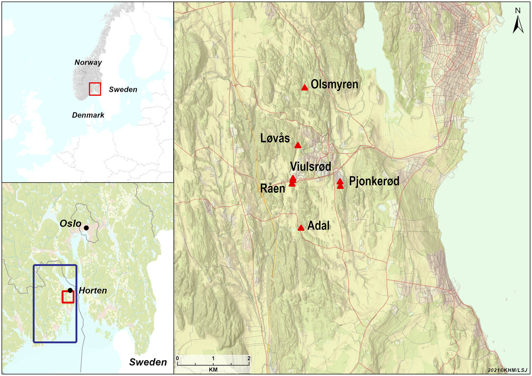
Map showing the project area in Norway and N-Europe. Sites named in the text are plotted on the map to the right. Blue square refer to the map section in Figure 11. Map: Linnea S. Johannessen, MCH, University of Oslo.
Key data for Middle Mesolithic sites discussed in the article. For site locations, refer Figure 1
| Site | C14-date (cal 2σ) * | Shoreline date (cal BCE)** | m a.s.l. (shoreline at earliest possible occupation) | Total area/excavated area (sampled area) |
|---|---|---|---|---|
| Løvås | 22 dates: 8240−7660 cal BCE (LuS-15285–15305, 15307– 153012, 16056) | 7800−7600 | 83−89 (83) | 3,800 m2/280 m2 |
| (120 m2) | ||||
| Olsmyren | − | 7500−7200 | 71−72 (70) | 55 m2/0 m2 |
| (18.5 m2) | ||||
| Viulsrød 1 | − | 7500−7200 | 71−74 (70) | 600 m2/0 m2 |
| (33 m2) | ||||
| Viulsrød 2 | − | 7100−6900 | 67−69 (66) | 500 m2/46 m2 |
| Råen 1 | − | 7100−6900 | 65−66 (64) | 150 m2/0 m2 |
| (16.5 m2) | ||||
| Adal | 5 dates: 7075−6690 cal BCE (LuS-15270, 15274) | 7100−6900 | 64−72 (63) | 5,100 m2/237 m2 |
| Pjonkerød A | 1 date: 7045−6697 cal BCE (Ua-47916) | 7000−6800 | 60−62 (60) | 760 m2/84 m2 |
| (22 m2) | ||||
| Pjonkerød B | − | 7000−6800 | 62−65 (60) | 1,220 m2/0 m2 |
| (24 m2) |
*Conventional radiocarbon ages are calibrated using the IntCal13 atmospheric curve (Reimer et al., 2013) and OxCal v.4.4 (Bronk Ramsey, 2009). For uncalibrated dates, see Supplementary File 2.
** Approximate earliest settlement date based on the shoreline displacement curve and estimated shoreline at earliest possible occupation. For data see Supplementary Files 1 and 2.
An important factor for the human–environment relation throughout the entire postglacial period is the strong isostatic land uplift in the Oslofjord area, causing continuous and rapid changes in the shoreline configuration and its nearby environments, both above and below sea level. Living with such fluctuating surroundings would require adaptive and flexible subsistence and enculturation strategies. To be able to study this process, we present a new relative sea level (RSL) curve supplying detailed data on the shoreline development in the area.
1.1 Natural Background – Environmental Data
During the MM, the Oslofjord area was marked by considerable environmental changes due to the isostatic land uplift after the Ice Age. At the time of occupation, all of the eight excavated sites were situated on islands along the coast, but are today located at c. 60–90 m a.s.l. and c. 4 km inland (Figures 1 and 3 and and 11).
In the MM, a large archipelago with fjords cutting westwards into the mainland characterised the area. The islands varied greatly in size and characteristics — from tiny islets and skerries surrounded by the open sea, to larger islands with sheltered bays, surrounded by shallow waters and separated from the mainland by narrow fjords and sounds (Figure 2). The sites discussed in this article were all centrally placed in this environment, accessing both open sea and sheltered waters, with presumably rich food resources throughout the year. Transport and communication would to a large degree depend on using boats, or alternatively travelling on ice during winter. The freshwater supply would likely be problematic and unstable around the sites that were situated on islands, especially in the summertime.

In the MM as today, the Norwegian archipelago with islets and skerries surrounded by the open sea, as well as larger islands with sheltered bays, surrounded by shallow waters. Photo: Tom Ingebrigtsen.
The boreal environment encompassed a rich flora and fauna. In the terrestrial habitats, we would expect varied woodlands offering herbs, edible berries, and hazelnuts, as well as large and small mammals such as elk, brown bear, wolf, wolverine, beaver, and red fox (Jonsson, 1995). Furthermore, the archipelago provided good access to a diversity of marine species such as small whales, seals, fishes, and molluscs, as well as seafowls, which would have been available all year around (Bjerck et al., 2016; Jonsson, 1995; Mansrud & Persson, 2018; Solheim & Persson, 2016).
From our excavated sites, the data on vegetation and animal sources are limited due to poor preservation of organic materials; however, there are indications of exploitation of both marine and terrestrial resources. Of the burnt bone found at the sites Løvås, Adal, and Pjonkerød, only a couple of species were identified (Phocidae, Rangifer tarandus, and unspecified large terrestrial mammal; Supplementary File 4, Carrasco & Mjærum, 2015; Magnell, 2020). Large amounts of charred and fragmented hazelnut shells were recovered from Løvås, demonstrating the importance of this resource. The nutshells were found in several contexts across the site, although mainly within the three assumed hut floors. Hazelnut shells were also found in four MM contexts at Adal. C14-dates of hazelnut shells and the reindeer bone from Løvås, one bone from Pjonkerød, and four hazelnut shells from Adal, all correspond to the other dates of the respective sites (Supplementary File 2).
While the hazelnut shells and the reindeer bone demonstrate the exploitation of terrestrial resources by hunting and gathering, the bone from a seal represents the exploitation of marine fauna. The rare find of a reindeer bone in a Stone Age site context (cf. Boethius, 2018, with references) is the first date to the MM of this species in Southeast Norwegian coastal areas. This find points toward the possibility of contact with mountain areas, which would be the expected habitat of the reindeer in this period, the closest being c. 80 km inland. The amount of charred hazelnut shells suggests a large consumption at Løvås; however, charring of hazelnuts would also function as a means of conservation of a food source rich in energy and suitable for transportation (Holst, 2010). The possibility of human vegetation management in the Mesolithic, in order to favour the growth of this plant, has been suggested by several authors (for discussion cf. Gross et al., 2019).
2 Shoreline Displacement
Detailed knowledge of temporal and spatial changes in shoreline position is crucial when studying the human–environment relation through time, at a formerly glaciated coastline. The Norwegian coastline offers unique opportunities to reconstruct the RSL history in great detail, due to the widespread presence of isolation basins (Romundset, Lakeman, & Høgaas, 2018). These are topographic depressions in the bedrock surface, usually carved out by glaciers, that initially were below sea level after deglaciation, but at some point in time were lifted above and transitioned into freshwater lakes. The sediment record of such lakes may comprise marine-to-lacustrine transitory facies that can be identified and radiocarbon dated.
Due to the large variation in land uplift rates along the Norwegian coastline, local reconstructions of RSL change are needed for detailed investigations of shore-bound archaeological sites. Such knowledge was lacking for our study area, we therefore conducted a geological investigation as part of the excavation project (Romundset, 2021). In this article, we present and use a new, preliminary reconstruction of the shoreline displacement for the study area, covering the entire period since deglaciation until present. A new RSL curve has tentatively been drawn, based on the results from analyses of sediment cores from a total of 14 isolation basins located near the study area (Figure 3). The RSL curve, combined with detailed elevation models as well as field observations, enables us to reconstruct in detail how the coastal landscape has developed in this area. It further provides an independent chronology for the shore-bound archaeological sites. The complete new RSL observational dataset will be presented in a future paper, as part of a larger regional reconstruction of the shoreline history of the Oslofjord area.
The shoreline changes were most rapid immediately following deglaciation, with rates of RSL fall exceeding 14 cm per year on average (Figure 3). The rate was gradually reduced after only a few centuries and reached 3–4 cm per year on average through the period when our study sites emerged above sea level. The rate further declined and has probably been near-stable at ca. 0.5 cm/year since 5000 cal BCE until today. Interestingly, from our observational data, we identify a significant slow-down of the regression rate between ca. 6700 and 5800 cal BCE, which corresponds with the timing of the Tapes Transgression, which inundated coastal sites in western Norway (e.g. Bondevik, 2003).
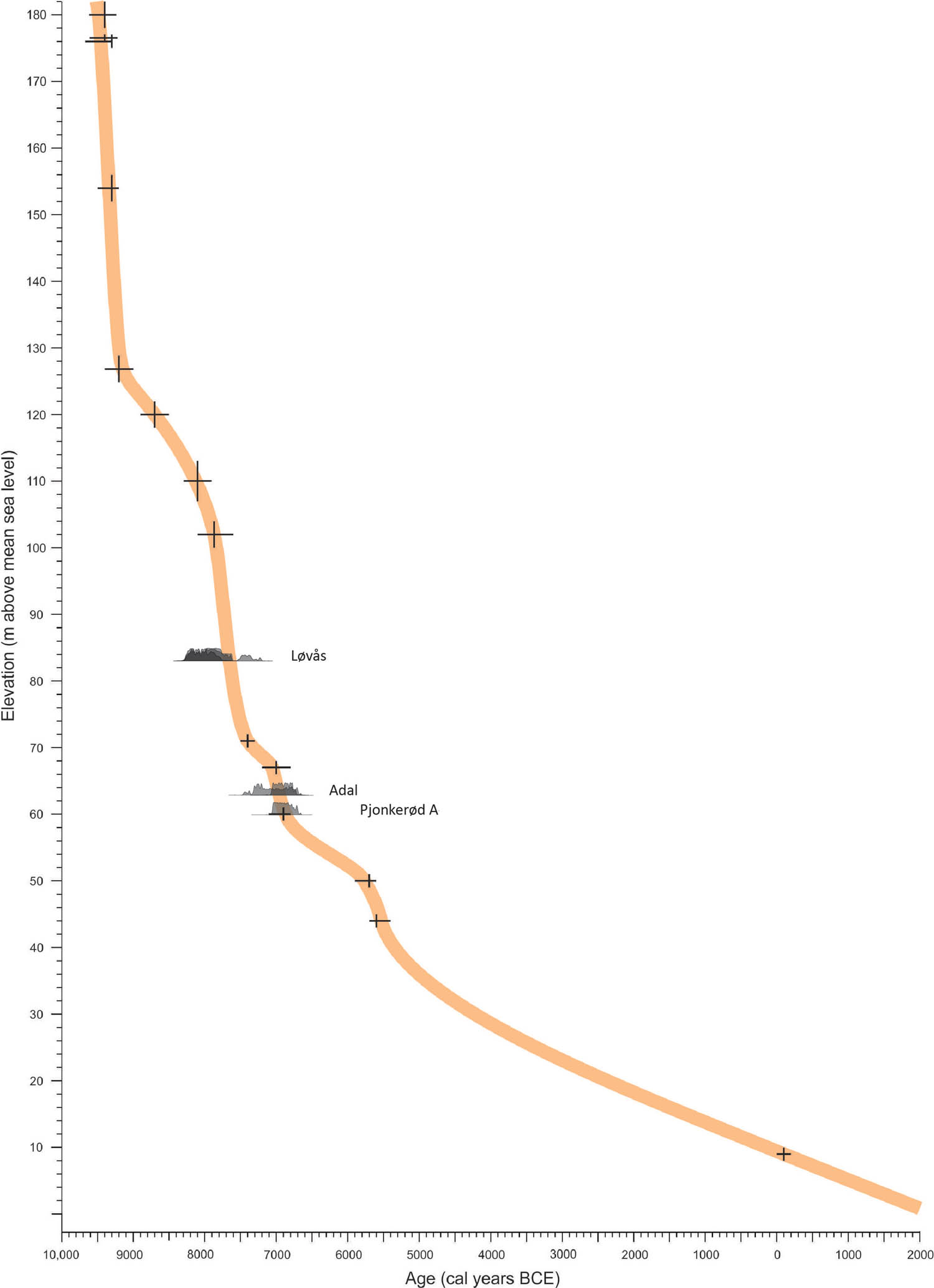
The new relative sea level reconstruction, representing the post-glacial development in northern Vestfold, SE Norway (Romundset, 2021). The sum calibration of C14-dates from three sites are plotted on the curve (confer chapter 3.1).
3 Eight Open-Air Sites by the Oslofjord, SE Norway
Our investigation includes eight MM open-air sites of diverse size and characteristics indicating variation in activities and settlement lifespan (Table 1, cf. Supplementary File 1 for detailed presentation of each site). The excavated sites are characterised by lithic scatters and in some cases structural remains such as remnants of dwellings and hearths. The lithic assemblages present information about tool inventory and technological organisation, providing the basis for dating on typological/technological grounds and interpretation of the site activities, as well as illuminate the human–environment relation. Together the data sets expand our knowledge about site variability and mobility patterns. Due to the acidic and well-drained soils in the area, organic materials such as bone or wood are rarely preserved. Although some bone fragments are present in the collections, the lithic assemblages combined with environmental data and site location are vital to understand the character of the settlements and their relations with the surrounding environment. The sites have been investigated with various intensity, from excavation of most of the central lithic scatters to sampling by single squares systematically distributed across the site (Table 1). Apart from the Løvås site, of which a part had been recently cultivated, the sites were situated in forested terrain, mostly showing no or very limited traces of historical or modern activity.
3.1 Dating the Sites – Technology, Bayesian Modelling of Radiocarbon Dates, and Shoreline Dating
A precise dating of the sites is imperative to the discussion of human–environment relations and site location in the area. The reason for this is the significant environmental changes that took place during the MM in the Oslofjord area due to the rapid displacement of the sea shoreline (Figure 3). The sites are dated by combining three methods based on independent datasets – technological and typological dating, C14-dating, and finally shoreline dating. These methods produce dates on different levels of precision; but, combined they allow us to date the occupation of sites to relatively short time spans. Furthermore, this enables us to date other excavated and surveyed sites in the same region with relative certainty despite the lack of C14-dates.
3.1.1 Technological Dating
The eight excavated sites contain artefact assemblages consistent with the technological and typological characteristics of the MM (Figure 4 and 8–10). The lithic assemblages are characterised by blade and microblade blank production from conical and sub-conical cores by indirect and pressure techniques, using flint as the main raw material. Diagnostic technical waste elements such as the cores, platform preparation flakes/core tablets, as well as characteristic blade blanks, reveal that the production method and products concur with the MM conical core pressure blade concept that dominates the small-tool blank production in Norway from c. 8300 cal BCE (Damlien, 2016; Manninen et al., 2021; Sørensen et al., 2013). Blades and microblades were used for a variety of tools such as inserts in slotted bone points, burins, cutting tools etc., and blade/microblade segments with transversal breaks characterise the assemblages from this period (Bergsvik & David, 2015; Damlien, 2016; Mansrud, 2013a; Sjöström & Nilsson, 2009). Also present are tools made from a variety of local volcanic rocks such as sandstone grinding slabs, polished chubby adzes and core adzes, which are characteristic of the period and present on most MM sites in Southeast Norway (Eymundsson, Fossum, Koxvold, Mansrud, & Mjærum, 2018; Fossum, 2014; Jaksland, 2001; Mansrud, 2013a; Mjærum, 2012; Reitan, 2016, 2022).

Diagrams illustrating the chronological development of the presence (percent of total assemblage) of tool types, core concepts, blades/microblades and different lithic raw materials between eight sites in Horten Municipality, northern Vestfold, – the oldest site Løvås to the left, the youngest Pjonkerød B to the right. The lower left diagram shows the relative distribution of flint (marked curve) and non-flint materials (filled bars), between the assemblages. For data see Supplementary File 5.
Although the technological chronology of the period still lacks detail, some traits seem to increase during the MM in the region. Examples of this is the presence of certain tool types and the exploitation of locally occurring rocks (cf. e.g. Damlien, 2016; Damlien et al., 2021, pp. 88–92, 137–147; Mansrud & Eymundsson, 2016; Reitan, 2022; Reitan, Danielsen, Gummesson, & Schülke, 2019, pp. 39–40). This is also reflected in our data (Figure 4, and Supplementary File 5). While curated tools constitute only a fraction of the total assemblages, the variation in tool types between the sites show several coinciding patterns. The most obvious is the dominance of microliths at the oldest site (Løvås), as opposed to the younger sites where microliths are markedly fewer. Similarly, there is a trend towards less blades and microblades (both retouched and unretouched) over time. Simultaneously we see an increase in the number of adzes and grinding slabs from c. 7000 cal BCE, as well as an increase in the exploitation of non-flint materials, which is mainly related to the number of the large tools in the assemblages (cf. Reitan, 2016, 2022 for similar observations).
3.1.2 C14-Dating and Bayesian Modelling
Three of the sites (Løvås, Adal, and Pjonkerød A) produced 26 samples of charcoal and nutshells and two samples of burnt bone, which have all been C14-dated to a relatively confined period of the MM (Table S3-1 in Supplementary File 3). The samples are from 19 contexts distributed across the sites (Supplementary File 1).[1]
In order to summarize the distribution of radiocarbon dates, we produced a Kernel Density Estimate plot (Figure 5, KDE; Bronk Ramsey, 2017). Here we include all samples dated to the Mesolithic from activity areas at Løvås, Adal, and Pjonkerød A (Figure 5, and Supplementary Files 2 and 3). Further, we investigate the start and end of activity at Løvås. By using Bayesian tools available in OxCal v.4.4 (Bronk Ramsey, 2009), we have developed a simple phase model providing posterior density estimates for start and end boundaries. The KDE plot shows that the dated samples are distributed between c. 8600 and 6400 cal BCE (Figure 5, and Supplementary File 3). The bimodal distribution indicates two activity phases that relate to an early phase of activity at Løvås, around 8000 cal BCE and later activity at Adal and Pjonkerød A, around 7000 BCE.
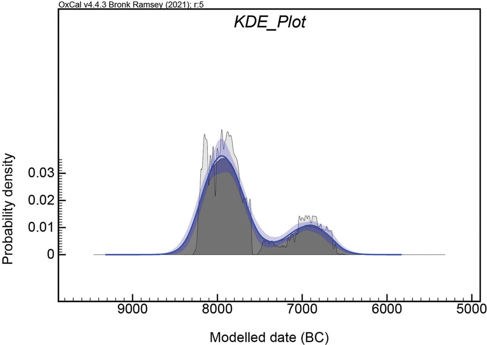
KDE-plot of all dates from the InterCity-sites and Pjonkerød show a bimodal distribution reflecting the chronological distribution of dated events and main activities at the sites. A model = 100, A overall = 99.3. For data see Supplementary File 2.
The archaeological assemblages and the radiocarbon dates demonstrate a large degree of contemporaneity in use of the different activity areas at Løvås and Adal, respectively. To investigate this possible internal contemporaneity within each site, we produced a Phase model in OxCal including the Løvås-dates (the Adal site produced too few dates).
The estimated start boundaries of the three activity areas at Løvås are all dated between c. 8500 and 7400 cal BCE (95% probability), or most probably between c. 8200 and 7840 cal BCE (68% probability, cf. Table S3-1 and Figure S3-2 in Supplementary File 3). The end boundaries are estimated to date between c. 8090 and 7400 cal BCE (95% probability) or most probably from 7880 to 7630 cal BCE (68% probability). The Span function in OxCal indicates a duration of activity up to c. 500 years (68%). There are some variations in the estimated start and end of activities at the Løvås site. We suggest that this represents either one concentrated or only a few consecutive and relatively contemporaneous activity phases that cannot be separated by C14-dating.
3.1.3 Shoreline Dating
Being an established method for dating Stone Age sites in Norway, shoreline dating has proven to be a valuable addition to the other dating methods (Bjerck, 2008; Bjerck, Meling, & Åstveit, 2008; Damlien et al., 2021; Jørgensen, Pesonen, & Tallavaara, 2020; Roalkvam, 2022; Simpson, 2009; Solheim & Persson, 2018; Tallavaara & Pesonen, 2020). Nevertheless, several authors have pointed out that we cannot assume an automatic link between the shoreline and the settlements, due to the large number of factors that would have affected the choice of site location in the Stone Age (Berg-Hansen, 2009; Berg-Hansen, Mjærum, Roalkvam, Solheim, & Schülke, in press; Mjærum, 2019, 2022; Schülke, 2020). Further, there is a question of data representation due to external factors affecting the identification of sites today, such as modern exploitation, and the intensity and choice of survey methods (Berg-Hansen et al., in press; Berg-Hansen, 2009). For instance, all the excavated sites discussed in this article are situated along a narrow corridor in the terrain for the planned InterCity railway, crossing several of today’s hills and valleys. This corridor partly follows the MM coastline, hence representing a limited selection of environs and possible site localisations. Yet, in this case, and similarly to several other areas along the Oslofjord, a strong correlation of C14- and typo-technological dating of archaeological contexts with the Mesolithic shoreline (cf. above) indicates a location pattern where Stone Age sites to a large degree were situated close to the seashore.
The RSL curve supports the results from the Bayesian modelling, and adds further precision to the dating of the sites. The comprehensive sea level changes in the area during the MM implies that at one point the sites have emerged from the sea, hence marking the earliest possible time of habitation. Due to a varied topography in the area, the rapid drop in sea level enables a narrowing of the period where the shoreline was relevant to the sites’ location. The pace of the sea level drop represents a key factor in understanding the temporality of sites through its effect on the topographical qualities of the settlement sites.
The C14-dates from the Løvås, Adal, and Pjonkerød A sites correspond well with the RSL curve, which in turn strongly indicates that the three sites were closely related to the shoreline at the time of occupation (Figure 3). If we assume the same pattern of location for the five remaining sites, of which none offered material for C14-dating, the RSL curve provides the necessary tool for dating these sites based on their proximity to the contemporary shoreline (Table 4). To calculate the shoreline date of each site, 1 m below the lowest measured point of the lithic scatter is used as basis (i.e. shore level at earliest possible occupation), taking into account variation in waves and tidal zones, as well as inaccuracy and local variations in the RSL curve.
3.1.4 Concluding Dating
In order to test the correspondence between the dating methods, we summed all dates from the different sites and compared them with the development in the RSL. The radiocarbon dates are in overall agreement with the suggested dating according to the recently developed RSL curve (Romundset, 2021). While the dating methods display consistent results at Adal and Pjonkerød A, there is a discrepancy between the radiocarbon dates from the archaeological contexts at Løvås and the RSL curve as the sum plot dates indicate a slightly older age than the RSL (Figure 3).
Here we want to emphasise that both the radiocarbon dates and the RSL curve, which is based on several radiocarbon dates and interpolation of dated levels from several basins, contain an element of chronological uncertainty. As the regression rate is high during the early Holocene, even small variations in height above sea level represent a relatively long-time span on the curve. Therefore, one should not expect a pointwise correlation between the two datasets in all circumstances. In this case, the relation between the two dataset seems to agree as they overlap. A more thorough statistical testing of the relation between radiocarbon dates of archaeological contexts and shoreline curves in the region is welcome.
In summary, all the three dating methods, based on three independent sets of data, concur placing the activity on each of the sites Løvås, Adal, and Pjonkerød A within relatively limited time spans of 200–300 years (Table 1), assuming the lower boundary for the C14-dates represents the youngest activity. The strong correlation of the shoreline dating with the results of the other dating methods reinforces the argument for using the RSL curve to date sites in the area lacking material for radiocarbon dating, presuming that all the excavated sites concur regarding a shore-bound pattern of location (Table 1, and Supplementary File 1). This reasoning also allows an estimated date of surveyed sites with topographical characteristics that agree with a shore-bound location (Figure 11, and Supplementary File 6).
3.2 Site Structures and Extent
Our results show major differences between the eight excavated sites concerning several features, notably the presence of structures, size of site area, and assemblage size and character. A number of factors may have affected these variations, such as natural conditions related to local topography and access to resources, and as already mentioned, chronological variation in material culture and technological traditions. While taking this into account, differences in on-site activity and organisation would still have noticeable influence on the formation of a site and the traces we are able to record. Investigating the observed variation, we focus on two main aspects of site use; evidence of on-site activity and organisation, and length and number of visits, building our discussion on the remnants of structures, site area, lithic assemblages, and the few preserved organic remains. These aspects are essential in understanding the mobility pattern that these sites were a part of, and the enculturation process that went on in the early part of the MM.
Our sites have been investigated with varying intensity, affecting our knowledge about their extent. Still, based on the distribution of lithic scatters in combination with the varied topography, including steep slopes and rock outcrops that delimit possible dwelling areas, we have been able to identify the main activity area of each site. Further, the sites were excavated or sampled to ensure a sufficient artefact selection, enabling an assessment of the character of the sites and their assemblages.
3.2.1 Site Size – Area and Assemblage
The eight excavated sites vary greatly in area, between 55 and 5,100 m2 (Table 1). We distinguish between three groups of sites regarding size – small, medium, and large, referring to the relative variation in area and number of lithic artefacts between the discussed sites (cf. Tables 1 and 2, and Supplementary File 1). The two largest sites Løvås and Adal covering 3,800 and 5,100 m2, respectively, comprise unusually large areas with an almost contiguous distribution of artefacts and structures. They, as well as Pjonkerød A, consist of several topographically delimited surfaces, each including artefact concentrations and structures. Within the context of South Norwegian Stone Age heritage management as well as in the research literature, such surfaces/concentrations are often described as separate units/sites. In our opinion, which concur with recent publications (Berg-Hansen et al., in press; Dugstad, 2020), this site-concept is unable to properly capture the observed variability of land use and settlement practice. At our sites, the surfaces are located close to each other, showing similar dates, assemblages and site organisation. We therefore suggest that the various surfaces and concentrations within each of these sites should be seen as parts of a whole, and the sites considered as large contiguous activity areas, stemming from several simultaneous or consecutive visits, a place involving common memories and narratives (Supplementary File 1).
The Løvås and Adal sites differ concerning the distribution and amount of structures and artefacts. Løvås displays more artefact material concentrated in a smaller area, and several preserved structures, while at Adal the artefacts are generally very scattered over a large area and with only a few smaller concentrations as well as few preserved structures. The Pjonkerød sites (A and B) cover smaller areas, but are still of considerable size (760 and 1,220 m2, respectively). In addition, Pjonkerød A encompasses a relatively large lithic assemblage as well as a tent structure and a hearth. Pjonkerød B was only sampled, which has probably resulted in a less representative assemblage. The diversity of the assemblage from this site, however, indicates that it should be considered as a medium sized to large site (Table 2).
Interpretation of the eight excavated sites from Horten Municipality, northern Vestfold
| Site | Area | Structures | Lithic artefacts (amount) | Assemblage | Number of visits | Settlement duration |
|---|---|---|---|---|---|---|
| Løvås | Large | 3 possible sunken floors and eight hearths | 15,635 | Large and varied | Multiple | Long |
| Olsmyren | Small | None | 2,059 | Medium and less varied | Single/few | Short |
| Viulsrød 1 | Medium | None | 203 | Small and less varied | Multiple/few | Short |
| Viulsrød 2 | Medium | None | 750 | Small and less varied | Multiple/few | Short |
| Råen 1 | Small | None | 78 | Small and less varied | Single | Short |
| Adal | Large | 1 Possible tent ring and 3 hearths | 14,309 | Large and varied | Multiple | Long |
| Pjonkerød A | Medium | 1 Tent ring | 6,090 | Large and varied | Multiple | Long |
| Pjonkerød B*) | Medium | None | 237 | Small and varied | Multiple | Long |
*The investigation (sampling) of Pjonkerød B only involved a small part of the site (cf. Table 1), hence the suggested interpretation should be treated with caution, in particular concerning the lack of solid structures and the size and composition of the lithic assemblage.
The Viulsrød sites comprise even smaller areas (500 and 600 m2) and small assemblages. The Olsmyren site covered a very small area (55 m2) but at the same time produced a significant, though less diverse, assemblage. The small site Råen 1 (150 m2) was situated on a very small island, with no opportunities to expand the settlement. A very small assemblage was recovered here (Table 2).
3.2.2 Dwellings and Hearths
Dwelling structures and hearths were discovered at the three largest excavated sites (Table 2, Figure 6), while no such structures were identified at the smaller sites. At Løvås three possible hut floors were identified (Figure 6). The structures comprise circular/oval delineated areas (c. 4.5 m across) with 0.2 m deep layers containing a large concentration of charred and fragmented hazelnut shells, charcoal, discarded lithic tools and production waste, as well as a few fragments of charred bark. Varying greatly from the rest of the site in both depth and content, these structures are interpreted as possible hut floors. Similar types of dwellings have been identified at several known sites from the same period (Fretheim, 2017; Holst, 2010; Mansrud & Persson, 2016; Mjærum, 2019; Solheim & Olsen, 2013). At Pjonkerød A and Adal, possible floors for tents were also documented. At Pjonkerød A, the structure comprised a partly preserved ring of weight stones assumed to have held a tent in place. At Adal, a ring of weight stones was more difficult to distinguish; however, an artefact concentration partly overlapping with a scatter of large stones resembling the structure at Pjonkerød A was interpreted as the foundation of a tent or a similar type of dwelling. A distribution of different tools and debitage in two distinct areas within this concentration, indicating the presence of delineated zones of activity, further strengthen this argument (Glørstad, 2010, pp. 121, 126–128; Granados, in press). Similar formations, or rather alignments of cobbles, have been documented and discussed as remains from tent structures at another MM site in the region (Mansrud, 2013b), and are also known from other parts of the Mesolithic in other regions of Norway (Bang-Andersen, 2003; Ramstad, 2014; Fretheim, Bjerck, Breivik, & Zangrando, 2018; Fretheim, 2017; Reitan et al., 2019, pp. 36–38).

Dwelling structures: Tent floors at Adal (no. 1) and Pjonkerød A (no. 2), and one of the hut floors at Løvås (no. 3). The artefact distribution within the structures is indicated by yellow dots for no. 1 and 3, an by grey dots for no. 2. A dashed circle suggests the extent of the floor of each structure, showing the similarity in size. Maps: Tina Granados, Axel Mjærum and Linnea S. Johannessen, MCH, University of Oslo.
The hearths were all simple constructions, comprising irregular depressions in the ground filled with fire cracked/heated rocks of various sizes and qualities, as well as soot and small fragments of charcoal. In all, 12 hearths were dated to the MM settlement phase, – eight hearths at Løvås and 4 at Adal.
3.3 Lithic Assemblages – Raw Material Economy, Technological Organisation, and Tools
The lithic assemblages from the eight sites disclose variations across several aspects of procurement and management of lithic raw materials, shedding light on human–environment relations and mobile patterns in the MM. Focusing on raw material procurement, production strategies, technological organisation of tool production, and the presence of various tool types, we also discuss on-site activity and the opportunities for planning for future situations as part of this.
3.3.1 Lithic Raw Material Procurement
Flint dominates as lithic raw material in the eight assemblages, comprising between 87.2 and 100% (Figure 4 and 7, and Supplementary File 5). Access to flint of sufficient knapping quality would have been imperative to the production and maintenance of hunting equipment, e.g. as projectiles and sharp edges in slotted points. However, the access to flint of sufficient quality would probably have been unstable and at best sparse in the MM archipelago. In this area, flint does not occur in local moraines or bedrock, but only sporadically in beach deposits. Because this beach flint would have been of varying knapping quality, the supply of flint would, at least to some degree, probably rest on transport from the Swedish west coast (Berg-Hansen, 1999; Eigeland, 2015, pp. 83–124). The fact that flint is the primary material used for small tool production on the sites (Figure 4), despite the scarce natural occurrence in the area, suggests a conservative and traditional approach towards the use of lithic raw materials, not specifically adapted to the local raw material situation (cf. e.g. Damlien & Solheim, 2018, p. 356, for similar argument). The standardised technological strategies and tool types that dominate the flint assemblages (cf. below), is in line with such an approach.
Evidence of exploitation of lithic raw materials with better local availability than flint is present in seven of eight assemblages, although in varying and generally limited amounts (Figure 7, and Supplementary File 5). This is coherent with observations made on other contemporary sites in the region (Damlien, 2016, pp. 355–359). The provenance of these non-flint materials (i.e. rocks and minerals, e.g. basalts, diabase, sandstones, quartzite, and various quartz including rock crystal) is generally difficult to identify, commonly occurring in moraine deposits or in the bedrock in large areas. However, one rock of special interest to this question is the volcanic metarhyolite (i.e. ignimbrite) that was found in varying amounts in several sites. This rock commonly appears in Mesolithic sites along the western coast of the Oslofjord. It has a known occurrence in bedrock in the Ramnes Cauldron, a geological ring-dyke complex situated only 6 km west of the project area (Figure 11; Oftedahl, 1957; Sørensen, 1975), representing a possible local source for the procurement of this raw material (Fossum, 2014; Jaksland, 2012; Reitan et al., 2019, pp. 39–40; Viken, 2018). Together, the use of flint and non-flint demonstrates a well-organised lithic raw material strategy to ensure successful blank and tool production, including long-range transport of flint indicating a dependence on seafearing vessels, combined with a sufficient flexibility for exploring locally available lithic resources.
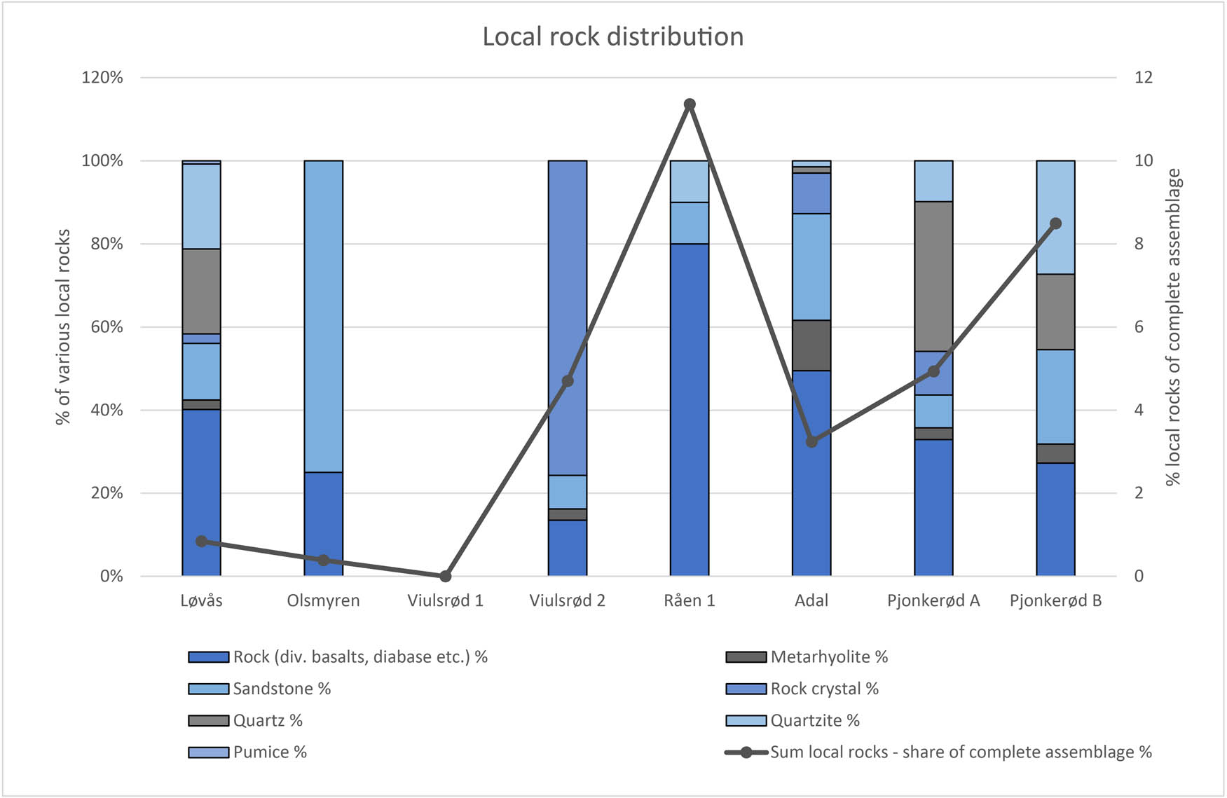
Distribution of different non-flint materials per assemblage (filled bars) and the relative amount of rock artefacts to flint artefacts (marked curve) in eight assemblages from Horten Municipality, northern Vestfold. For data see Supplementary File 5.
Further, the excavations have revealed indications of a chronological variation in the exploitation of non-flint as opposed to flint, while no clear pattern is observed regarding different rock or mineral types (Figures 4 and 7). Similar patterns have been observed on other contemporary sites in the region, and across time, we see an increase in the exploitation of non-flint materials in Southeast Norway (e.g. Damlien, 2016; Mansrud & Eymundsson, 2016; Reitan, 2022). Especially the basaltic rocks and metarhyolite have been directly or indirectly associated with known regional quarry-sites or local areas of origin (Fossum, 2014; Melvold & Eigeland, 2014; Nyland, 2016; Reitan et al., 2019; Sørensen, 1975; Viken, 2018). Evidence from Stone Age sites of the exploitation of locally occurring non-flint materials for tool production are generally appreciated as indications of a familiarity with and close connection to an area (e.g. Nyland, 2016, pp. 252–254, 2020; Taçon, 1991). The observed variation in our assemblages might be interpreted as a gradual increase in the knowledge of, and activity in, the area between 8000 and 7000 cal BCE (cf. Figure 4). Nevertheless, there is no clear development in the number of different exploited lithic raw materials. Already at the oldest site Løvås, at least 6 different non-flint materials had been exploited, demonstrating an exploration of local lithic resources already at c. 7800–7600 cal BCE.
3.3.2 Production Strategies – Chaîne Opératoire Analysis
Our lithic analyses are based on traditional typological classification of selected artefact types, as well as an overall assessment and reading of the complete assemblages. The latter method comprises a simplified chaîne opératoire and dynamic-technological analyses (modified after Eriksen, 2000; Schild, 1980; Sørensen, 2006a). This builds on the technological approach originally developed within French sociology and archaeology, which emphasises technology as a manifestation of society and tradition (Berg-Hansen 2018; Dobres, 2000; Inizan, Reduron-Ballinger, Roche, & Tixier, 1999; Mauss, 1973 [1935]; Pelegrin, 1990; Pigeot, 1990; Sørensen, 2006b). Combined with theory of cultural knowledge transmission, this approach enables the identification in archaeological assemblages of production methods and strategies representing technological traditions as well as raw material economy and the chain of technological operations involved in tool production and use (e.g. Berg-Hansen, 2017, 2018; Jordan, 2015; Perdaen, Crombe, & Sergant, 2008; Sørensen, 2006a; Stout, Semaw, Rogers, & Cauche, 2010; Tostevin, 2007).
Simplified chaîne opératoire and dynamic-technological analyses of the eight excavated assemblages demonstrate variation in on-site activity (Table 3). The analyses identify the presence or absence of various steps of production in each assemblage, dividing it into primary and secondary core preparation, and primary and secondary core exploitation, as well as tool production. Three, possibly four, main technological strategies can be distinguished concerning the production of tools from flint and non-flint raw materials, respectively.
Steps in the chaîne opératoire present in the flint assemblages from the eight excavated sites in Horten Municipality, northern Vestfold. Single nodules/reduction sequences are not separated; instead, whole assemblages are evaluated in this table. From the Pjonkerød sites, some information are not available (– = no data). (x = present, 0 = not present; method modified after Eriksen, 2000; Schild, 1980; Sørensen, 2006a,b)
| Step | Part of production process, flint | Artefact category present | Løvås | Olsmyren | Viulsrød 1 | Viulsrød 2 | Råen 1 | Adal | Pjonkerød A | Pjonkerød B |
|---|---|---|---|---|---|---|---|---|---|---|
| 1 | Primary core preparation | Large cortex flakes | x | 0 | 0 | 0 | 0 | x | − | − |
| Prepared and discarded fragments and blocks | 0 | 0 | 0 | 0 | 0 | x | x | x | ||
| Prepared, unexploited cores (preforms) | 0 | 0 | 0 | 0 | 0 | x | x | 0 | ||
| 2 | Secondary core preparation | Diverse cortex flakes | x | x | x | x | x | x | x | x |
| Core preparation waste | x | x | x | x | x | x | x | x | ||
| Trimming flakes | x | x | x | x | x | x | x | x | ||
| 3a | Primary core exploitation | Crested blades/microblades with cortex | x | 0 | x | x | x | x | 0 | 0 |
| Blades/microblades with cortex | x | x | x | x | 0 | x | x | x | ||
| 3b | Secondary core exploitation | Exploited or exhausted blade cores | x | x | x | x | 0 | x | x | x |
| Core fragments | x | 0 | 0 | x | x | x | x | 0 | ||
| Platform flakes and/or tablets | x | x | x | x | x | x | x | 0 | ||
| Crested blades/microblades without cortex | x | 0 | x | x | 0 | x | x | 0 | ||
| Blades/microblades without cortex and with less than 50% dorsal traces of core preparation | x | x | x | x | x | x | x | x | ||
| 4 | Tools and tool production waste | Curated tools (formal or expedient) | x | x | x | x | x | x | x | x |
| Curated tools – preforms | x | 0 | x | x | 0 | 0 | 0 | x | ||
| Microburins | x | 0 | 0 | 0 | 0 | 0 | 0 | 0 | ||
| Proximal blade segments | 0 | 0 | 0 | 0 | 0 | x | − | − | ||
| − | Non-diagnostic waste | Undetermined flakes/fragments | x | x | x | x | x | x | x | x |
| Small preparation flakes | x | x | x | x | x | x | x | x |
Steps in the chaîne opératoire present in the non-flint assemblages from the eight excavated sites in Horten Municipality, northern Vestfold. Single nodules/reduction sequences are not separated; instead, whole assemblages are evaluated in this table (x = present, 0 = not present; method modified after Eriksen, 2000; Schild, 1980; Sørensen, 2006a,b)
| Step | Part of production process, non-flint (rocks and minerals) | Artefact category present | Løvås | Olsmyren | Viulsrød 1 | Viulsrød 2 | Råen 1 | Adal | Pjonkerød A | Pjonkerød B |
|---|---|---|---|---|---|---|---|---|---|---|
| 1 | Primary core preparation | Large cortex flakes | 0 | 0 | 0 | 0 | 0 | 0 | 0 | 0 |
| Prepared and discarded fragments and blocks | x | 0 | 0 | 0 | 0 | x | x | 0 | ||
| Prepared, unexploited cores (preforms) | 0 | 0 | 0 | 0 | 0 | 0 | 0 | 0 | ||
| 2 | Secondary core preparation | Diverse cortex flakes | 0 | 0 | 0 | 0 | 0 | 0 | 0 | 0 |
| Core preparation waste | 0 | 0 | 0 | 0 | 0 | 0 | 0 | 0 | ||
| Trimming flakes | 0 | 0 | 0 | 0 | 0 | 0 | 0 | 0 | ||
| 3a | Primary core exploitation | Crested blades/microblades with cortex | 0 | 0 | 0 | 0 | 0 | 0 | 0 | 0 |
| Blades/microblades/flakes with cortex | 0 | 0 | 0 | 0 | 0 | x | 0 | 0 | ||
| 3b | Secondary core exploitation | Exploited or exhausted cores | x | 0 | 0 | 0 | 0 | 0 | x | 0 |
| Core fragments | 0 | 0 | 0 | 0 | 0 | 0 | 0 | 0 | ||
| Platform flakes and/or tablets | 0 | 0 | 0 | 0 | 0 | x | 0 | 0 | ||
| Crested blades/microblades without cortex | 0 | 0 | 0 | 0 | 0 | 0 | 0 | 0 | ||
| Blades/microblades/flakes without cortex and with less than 50% dorsal traces of core preparation | x | 0 | 0 | x | 0 | x | x | 0 | ||
| 4 | Tools and tool production waste | Curated tools (formal or expedient) | x | x | 0 | x | x | x | x | x |
| Curated tools – preforms | x | 0 | 0 | x | 0 | x | x | 0 | ||
| Flakes from adze production | 0 | 0 | 0 | 0 | 0 | 0 | 0 | 0 | ||
| Flakes from maintenance of curated tools | x | 0 | 0 | 0 | 0 | x | 0 | 0 | ||
| − | Non-diagnostic waste | Undetermined flakes/fragments | x | x | 0 | x | x | x | x | x |
| Small preparation flakes | x | 0 | 0 | x | 0 | x | x | x |
The flint assemblages are generally represented by all or most steps of blank and tool production (Table 3a, Figure 8, and Supplementary File 5). However, we observe that primary core preparation is only represented in four of the assemblages (notably in the most numerous collections Løvås, Adal, and Pjonkerød A, and by a few artefacts at the sampled site Pjonkerød B). In the other four assemblages, this step in the production is not represented. Secondary core preparation as well as primary and secondary core exploitation are present in all assemblages, although the number of artefacts from different steps varies greatly between the sites. Both retouched and unretouched blade/microblades (complete and fragments) are present in all assemblages, probably at least partly representing production and/or maintenance of composite tools. Also present in all assemblages are a variety of curated tools such as microliths, borers, scrapers, regular burins, and systematically produced blade/microblade segments with transversal breaks. The latter category also encompasses modified blade segments with or without burin bit function (i.e. rulers) (Sjöström & Nilsson, 2009; Sørensen, 2017)[2].
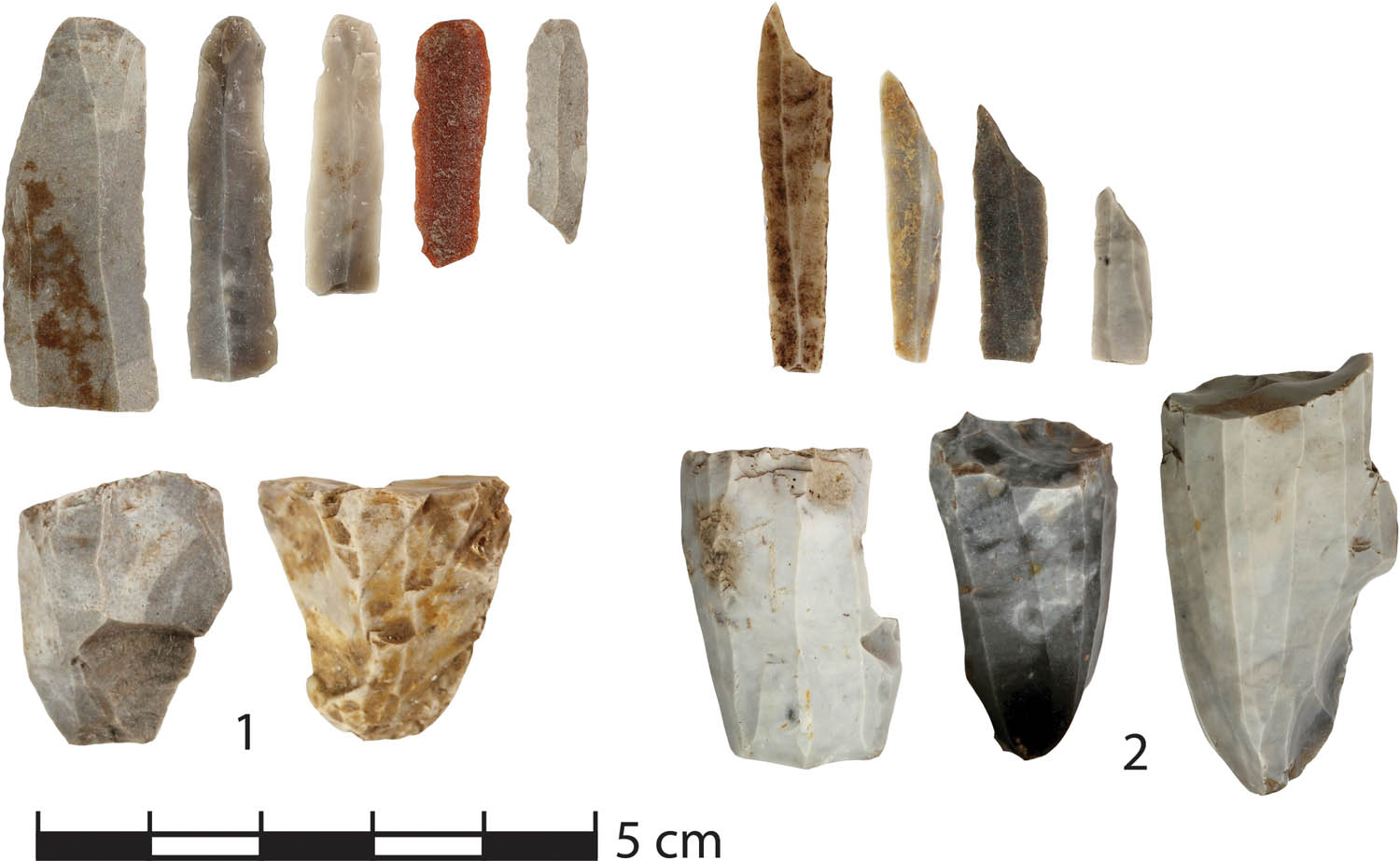
Typical flint artefacts. 1. Cores and blades/microblades from Adal. 2: Cores and microliths from Løvås. Photo: Silje Hårstad, Inger M. Berg-Hansen, MCH, University of Oslo.
Diagnostic waste materials from flint tool production or maintenance (e.g. microburins and proximal blade segments) are present at Løvås and Adal exclusively. Further, proximal blade segments, showing special characteristics that probably are diagnostic of waste materials from systematic production of blade segments, are documented in the Adal assemblage. These segments are characterized by perpendicular breaks resulting from a blow rather than bending, a method recognised in the post-Swiderian assemblage of Sujala in Northern Finland (Rankama & Kankaanpää, 2011).
The part of the assemblages comprising other lithic raw materials than flint present a coherent pattern (Table 3b, Figure 10, and Supplementary File 5), although encompassing a variety of lithic raw materials with different characteristics (cf. below), and hence exploitation for various purposes as well as several concepts of production. The first three steps in the chaîne opératoire (primary and secondary core preparation and primary core exploitation) are only represented by a few examples of blocks. Examples of secondary core exploitation (cores and blades) are present in low numbers at Løvås, Adal, Pjonkerød A, and Viulsrød 2. On the other hand, tool production waste and tools (readymade tools and/or preforms and adze preparation/maintenance flakes), as well as non-diagnostic flakes, are present in low amounts in all assemblages apart from the Viulsrød 1 assemblage.
We conclude that the complete chaîne opératoire of flint blank/tool production is present in the three largest assemblages (Løvås, Adal, and Pjonkerød A, and possibly at Pjonkerød B). This demonstrates the first main strategy, i.e. that all steps of production of flint tools were carried out on these sites. The smaller assemblages reveal the second strategy; the first part of the production process, involving testing, selection, and primary preparation of flint raw materials, was not performed on these sites. Instead, ready-made cores and/or blanks were brought to these sites from other places. Finally, the third strategy is visible in the variety of non-flint materials, where the primary and secondary preparation generally did not occur at the sites, nor did the primary production. However, the assemblage from Adal includes a few blocks of tested or unused materials (carry-sized blocks of volcanic rocks and quartzite with negative scars from removals, unexploited slabs of sandstone, and prisms of rock crystal). Although few in number, these artefacts show that procurement and testing of local non-flint materials did occur. The presence of ready-made non-flint tools and preforms, and non-diagnostic waste, demonstrates that while some preparation and maintenance of such tools were performed on the sites, they were mainly produced outside the sites. Our data thereby demonstrate two very different schemes in the management of flint as opposed to non-flint materials of probable local origin. Flint was to a large degree brought to the sites as nodules or prepared cores for further preparation and production on-site, while the primary preparation and production of blanks from non-flint materials mainly took place outside the sites, probably at the place of procurement (most likely naturally exposed deposits) (Damlien, 2016; Eymundsson et al., 2018).
3.3.3 Technological Organisation of the Tool Production
Several authors have suggested models for interpreting the site character and length of occupation based on the technological organisation (e.g. Inizan et al., 1999, Figure 3; Larson & Kornfeld, 1997; Knell, 2012). Various scenarios that affect this organisation, and are thus reflected in the lithic assemblages, are described by Larson and Kornfeld (1997, p. 13). Included in these scenarios is variation in the time available for chipped stone production, which is linked to the length of the occupation and the predictableness of future events. It is our opinion that the model has a general significance for how we can understand patterns in lithic assemblages from Stone Age sites. This is based on the idea that variability between assemblages in the presence of steps in the chaîne opératoire (i.e. artefact types, cf. above) reflects variation in procurement strategies and exploitation of stone raw materials, i.e. the raw material economy. In a situation with an abundance of available time for tool production and a foreseeable need for specific tools in the future, the model from Larson and Kornfeld (1997, p. 13) shows that the complete production process can be anticipated to be present in the assemblage, together with partial production sequences and imported blanks and tools. Opposed to this, in situations where the time is limited and the future is uncertain, the lithic assemblage will display incomplete production sequences but with a focus on production and maintenance of tools, and frequent occurrences of imported blanks and tools.
In the assemblages from the eight excavated sites in Horten Municipality, three main technological strategies have been identified; two for the flint assemblages and one for the non-flint materials (cf. above, Table 3a and b). Although our analysis includes complete assemblages, and does not discuss single nodules or raw materials (cf. description of Minimum Analytical Nodules analysis by Larson & Kornfeld, 1997), we are able to distinguish a trend in the distribution of different strategies between the sites.
The two dissimilar strategies for exploiting the flint raw material show different occurrences at the various sites indicating different situations in terms of available time and whether the future was known or not. As described above, artefacts from all parts of the chaîne opératoire are identified at the large sites (Løvås, Adal, and Pjonkerød A and B), including traces of the primary core preparation (unprepared nodules, core preforms, and primary preparation flakes). This demonstrates a strategy where all steps of the production sequence, including production of generalised tools, took place at these sites – indicating a situation where time was plentiful and the future predictable. At the smaller sites, a second strategy is applied to the flint material. Here traces of the primary core preparation are missing, indicating that this part of the chaîne opératoire was performed outside the sites. Prepared cores were brought to these sites, suggesting a limited time horizon and the planning for unpredictable situations that might occur, demanding production of new tools or retooling. At all sites, flint blanks were produced in varying amounts, tools were rejuvenated, and cores and tools were discarded.
The third strategy, identified at all sites but Viulsrød 1, is related to the exploitation of non-flint materials and must be seen in relation to the flint tool production strategies on each site. The assemblages show few traces of initial preparation or blank production in non-flint materials, although there are some examples of unexploited or partly exploited raw materials and cores being left at the sites (e.g. at Adal). Mainly the last steps of the chaîne opératoire, i.e. completing the tools, using, maintaining, and rejecting them, were carried out at the sites. Some of the assemblages have flakes from various non-flint materials but lack tools in corresponding raw materials. Such “solitary” flakes might reflect initial preparation processes for tool production before being transported away from the sites, but might also represent maintenance.
3.3.4 Tool Types
Different tool types are present in the assemblages, indicating a variety in activities between sites. Although the curated tools and blanks left at the sites were rejected or lost, it is likely that they reflect the variation in both tasks performed at the site and preparation for tasks outside the site. Figure 4 shows a chronological variety in tool types; however, a variety independent of chronology can also be identified in that we generally see a correspondence between the assemblage size and the number of tool types (Figure 9).
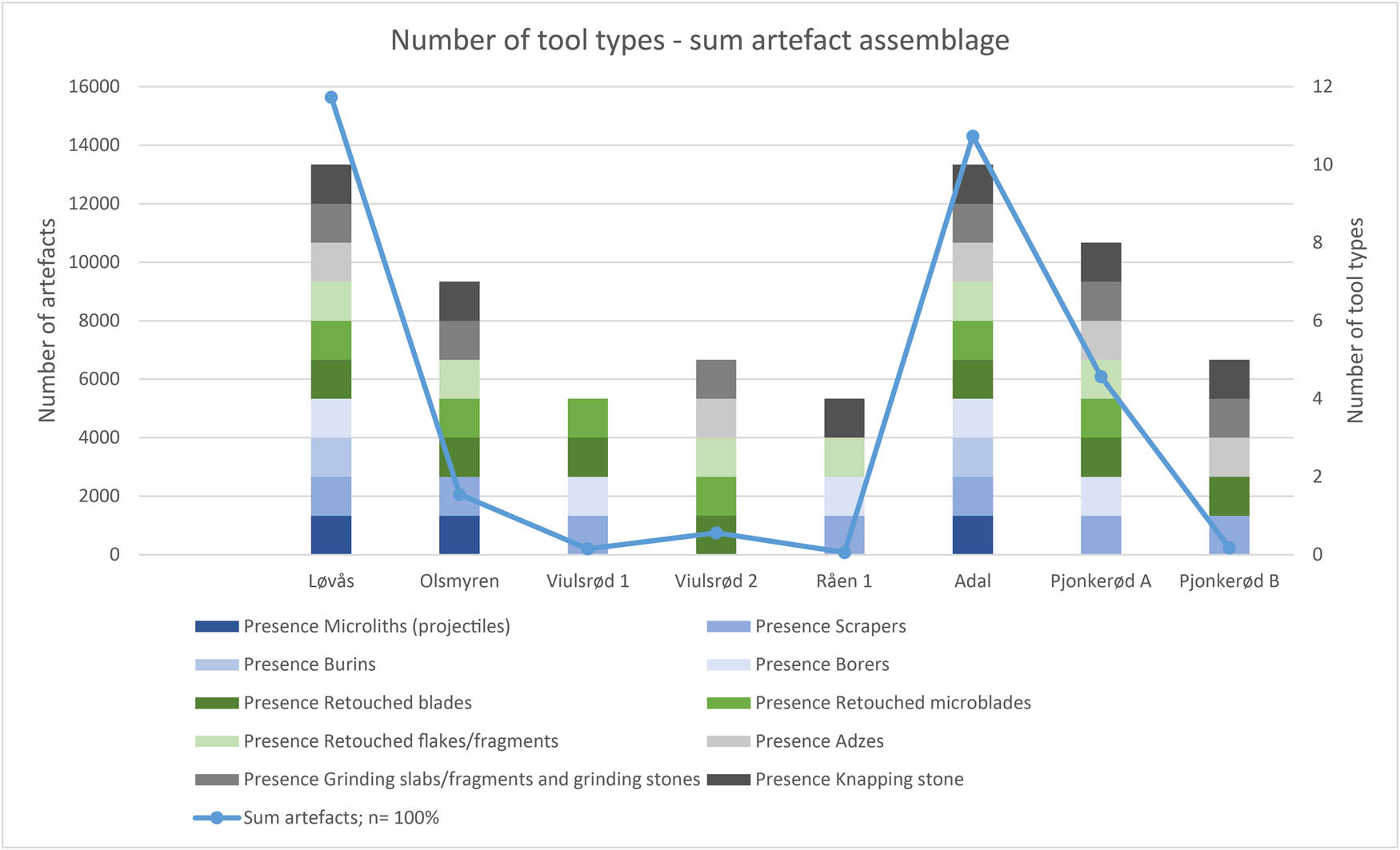
Diversity in the presence of tool types in eight assemblages from Horten Municipality, northern Vestfold. Number of tool types partly co-varies with the size of the complete assemblage, although not completely. For data see Supplementary File 5.
The large assemblages from Løvås, Adal, and Pjonkerød A display a diversity of curated and expedient tools, demonstrating multiple activities (Figure 4 and 8–Figure 10). While the presence of projectiles (microliths, inserts) points toward hunting away from the site, tools for scraping, boring, and cutting generally suggest domestic activities.

Typical rock adzes and a sandstone grinding slab refitted from several fragments (no. 1−3. Adal; 4. Løvås). Photo: Inger M. Berg-Hansen, MCH, University of Oslo.
Three small assemblages, Viulsrød 1, Råen 1, and Pjonkerød B, show a somewhat different pattern. Viulsrød 1 and Råen 1 comprise no large tools (apart from one knapping stone at Råen 1), while small amounts of curated small tools, retouched blades, and flakes/fragments are prominent (Figure 4). The composition of these assemblages might indicate activity of a different character compared to the larger sites. Pjonkerød B comprises a small assemblage due to the sampling strategy, still including a selection of diverse tools. As mentioned above, it is possible that the character of the site was not completely captured by the investigation, as might be the case for Viulsrød 2, which was also sampled. The somewhat larger assemblage from Olsmyren represents an intermediate position, comprising a small, yet diverse, amount of tools.
4 Site Variability and Mobility Pattern
We have seen that the eight excavated sites vary greatly regarding several different features. Still, and largely in agreement with observations otherwise in the Oslofjord region (Damlien & Solheim, 2018), we are able to distinguish patterns that can be interpreted as representing dissimilar activities, and varying number of visits and length of occupation (Table 2). We emphasise that these patterns should not be understood as fixed concepts, but rather as examples within a continuum of potential variation. Single sites discussed here might easily be interpreted in terms of explanation models building on economics and practicalities of life as the main motivation for the organisation of the society. On the other hand, if we compare the sites, variations are more evident than conforming patterns (Kelly, 1992, 2013).
At least two, possibly four, sites can be described as large- or medium-sized sites representing extensive occupations over long time spans (e.g. several months), and counting several visits. The sites Løvås and Adal stand out in covering extraordinarily large areas (3,800 and 5,100 m2, respectively) and exhibiting extensive and varied lithic assemblages (c. 15,600 and 14,300 lithic artefacts). In addition, the Pjonkerød A site displays similar traits, although comprising a smaller area and assemblage (760 m2 and 6,090 lithic artefacts)[3]. The three sites encompass dwelling structures and hearths, and would have had room for large groups, or several social units simultaneously, residing for a long period of time. In addition, they exhibit varied assemblages in terms of steps in the chaîne opératoire, demonstrating the planning for future activities, lithic raw material exploitation, and tool types, as well as organic remains from meals and tools. Together this represents a large spectrum of activities and a diverse organisation of tasks. Based on this, we interpret these sites as long-term occupations and as several consecutive visits to the same place (Table 2), probably representing established places of residence with special significance in peoples mind (cf. e.g. Ames, 2002; Chatters, 1987; Grøn, 2014, Stewart, Keith & Scottie, 2004).
The two types of dwelling structures that were identified (sunken hut floors at Løvås, and tent structures at Adal and Pjonkerød) possibly represent two different strategies of settlement. The hut floors, assumed to represent a form of solid house structure, have probably required a greater investment of labour compared to a tent structure that is designed to be erected several times (Fretheim et al., 2018). Additionally, while the hut floors presumably represent permanent structures, tents can be dismantled and moved away. The presence of hut floors may therefore be seen as indications of more long-term settlements compared to remains of tent structures demonstrating a very mobile existence (Bjerck, 1990, 2008; Cribb 1991, pp. 105–107; Fretheim et al., 2018; Solheim & Persson, 2016). Further, it is possible that the variation in structure and artefact distribution between the two largest sites (Adal with artefacts thinly scattered over a large area and few preserved structures and Løvås with more artefact materials concentrated in a smaller area) reflects the intensity of the use of the two sites and that Løvås was visited more often or longer, or by more people. This could also indicate dissimilar strategies in waste disposal and site management. In concordance with the concept of anticipated mobility, predicting maintenance and clearing of sites when re-visits or a lengthy stay were planned (Fretheim et al., 2018; Kent, 1991), the Adal site shows a low degree of accumulation of debitage products. Similar distribution patterns have been documented on several other MM sites in the region (Ekstrand & Berg-Hansen, 2013; Mansrud & Eymundsson, 2016).
The sites Olsmyren, Viulsrød 1 and 2, and Råen 1 can be described as of medium or small size resulting from several, however probably fewer visits, each comprising a shorter occupation compared to the large sites. Although varying greatly in area and amount of lithic artefacts, they still exhibit several common traits. Solid structures have not been identified at any of these sites, and the assemblages are significantly smaller compared to the large sites. Furthermore, the assemblages show less variation in terms of types of tools and lithic raw materials, and they completely lack traces of primary core preparation in both flint and non-flint materials. Two of the sites (Viulsrød 1 and Råen 1) display a somewhat higher frequency of scrapers and borers compared to the other assemblages, as well as lack grinding slabs and adzes, indicating another technological organisation possibly involving specialised occupation purposes.
Building on the presentation of the sites above, we interpret these four sites as shorter occupations, representing a single or a low number of visits, allowing less investment in the building of solid structures (Table 2) and probably constituting other types of places in the MM encultured environment. The assemblages demonstrate a restricted, but diverse, spectrum of activities compared to the large sites. The lack of complete production sequences, which to a varying degree includes blank production, tooling, and retooling, indicates a tool production strategy oriented towards a more limited number of tasks, and at the same time being flexible towards unforeseen/unpredictable future needs. The site Råen 1 stands out as a particularly small site, situated on a tiny island and including a very limited assemblage with few tool types. Although this assemblage comprises a relatively high frequency of curated tools, the site can be interpreted as a short visit by a small social group performing a limited number of tasks. In several senses, the four smaller sites thereby probably would have represented different types of places compared to the larger sites.
To conclude, we observe the contours of a mobile system including sites with different purposes and positions, suggesting the presence of various types of places in the MM archipelago. Supporting this is the diversity of tool types, structures, and environmental data. On the one hand, there are medium-sized and small sites with room for only a small social group, staying for a limited amount of time at each site, performing specific types of activities in different places. The presence of mainly partial production sequences involving blank production, tooling, and retooling, suggests a strategy preparing for a less predictable future and few opportunities for planning, favouring flexible technological solutions able to meet several requirements. On the other hand, we see evidence of settlement of some duration, including opportunities to plan for activities both on and outside the sites. The very large sites are such examples with enough space for larger groups, or several social units, to gather over a longer period of time, carrying out a number of different tasks, re-visiting sites, planning ahead, and preparing for a foreseen future.
5 Site Location
To understand the enculturation processes in the Mesolithic, being able to reveal human–environment relations and mobility patterns, the placement of settlement sites in the terrain is essential (e.g. Darmark et al., 2018; Mjærum, 2022; Roalkvam, 2020; Schülke, 2020). We present the location of the excavated sites at two levels of detail – a micro level showing the placement with respect to the local topography, and a macro level presenting the location of each site in the larger district. To add further perspectives to the results from the eight excavated sites, we include 69 sites in the discussion of the site location at the macro level[4].
5.1 Location on a Micro Level
By reconstructing the shoreline development in the area (Figure 3), we are able to recreate the terrain within which each of the sites were placed (Supplementary File 1, and Figure 11). Assuming a shore-bound location for the excavated sites (cf. discussion above), we are able to determine their placement with respect to the local topography. The sites were situated either in bays or on headlands (Supplementary File 1, and Table 4). In many cases, islands and protruding headlands would have protected the sites from wind and waves from the south and east, and a hilly terrain gave shelter against northerly winds. Simultaneously there was easy access from the sites by boat to the large protected archipelago with a number of sounds and islets, as well as deep fjords facilitating trips to the inland. Such locations would give excellent access to marine and coastal resources, as well as terrestrial hunting game. All sites were situated on islands and had two or more harbouring options in the immediate vicinity, emphasising a marine oriented way of life and a dependence of seafaring vessels (cf. e.g. Mjærum & Mansrud, 2020, pp. 274–276; Solheim & Persson, 2016, discussing MM marine coastal adaption).
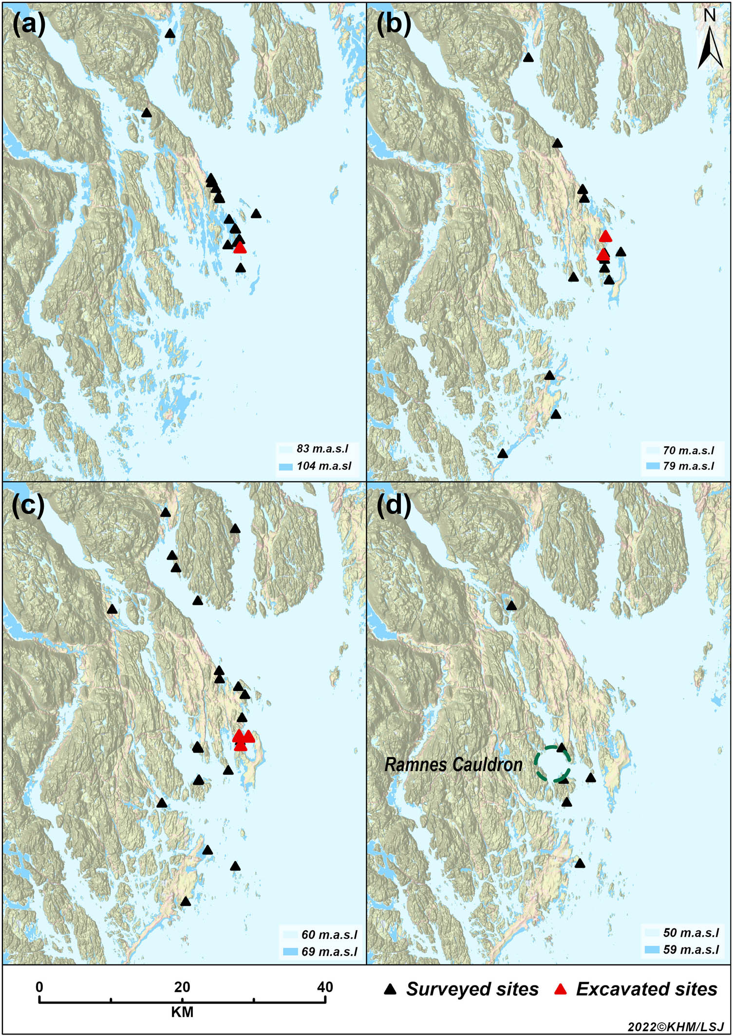
Development in the geographical distribution of MM sites (n = 77, including eight excavated sites) at 4 chronological stages (a−d) of the shoreline regression: (a) 8000–7800/7600 cal BCE; (b) 7700/7500–7300/7100 cal BCE; (c) 7300/7100–7000/68000 cal BCE; (d) 6900/6600–6300/6000 cal BCE. Some of the sites are situated very close, hence overlapping in the maps. For data see Supplementary File 6. Map: Linnea S. Johannessen, MCH, University of Oslo.
Topographical characteristics of the placement of the eight sites
| Site | m a.s.l. – shore level* | Mainland/island | By sound/open sea | Protected by islands/headland | In bay/on headland | Minimum number of inlets/possible harbours |
|---|---|---|---|---|---|---|
| Løvås | 83 | Very large island | Open sea | Yes | Bay | Two |
| Olsmyren | 70 | Very large island | Open sea | Yes | Bay | Two |
| Viulsrød 1 | 70 | Very large island | Sound | Yes | Headland | Two |
| Viulsrød 2 | 66 | Very large island | Sound | Yes | Bay | Two |
| Råen 1 | 64 | Small island | Sound | Yes | Headland | Several |
| Adal | 63 | Very large island | Sound | Yes | Headland | Two |
| Pjonkerød A | 60 | Small island | Sound | Yes | Bay | two |
| Pjonkerød B | 60 | Small island | Sound | Yes | Bay | two |
*Meter above sea level at the earliest possible occupation.
Three sites were situated on small islands (Supplementary File 1). The two Pjonkerød sites shared an island that at the time of occupation would have been large enough to house several sites or groups of people. Opposed to this, the small site Råen 1 would have covered the larger part of the tiny island where it was placed (Supplementary File 1). With its central, and at the same time protected, location this site would have been a perfect spot for scouting and hunting for sea mammals in the archipelago. With some distance to larger landmasses, the location on small islands could also function as safe places away from possible terrestrial predators. The remaining five sites were all situated on an island so large (537 km2 at shoreline 60 m a.s.l.) that it would have resembled the mainland, probably carrying forests and terrestrial fauna that could be hunted. Only a long narrow fjord separated this island from the main landmass.
5.2 Location on a Macro Level
An overview of the known (excavated and surveyed) sites in four municipalities in the northern Vestfold County, which are of probable MM Age, show variation in the settlement distribution during the period (Table 5, and Supplementary File 6). In order to identify the sites that can be dated to the MM, the artefact material has been assessed regarding typological and technological traits, local topography, and relation to the prehistoric shoreline (whether a shore-bound location is probable), in addition to context and finding conditions to make sure the finds have not been redeposited. To indicate the earliest possible settlement, the height a.s.l. is placed 1 m below measured height for each site on the RSL curve (cf. shoreline dating above). In the study area, heights between c. 54 and 114 m a.s.l. correspond to the shoreline in the MM (8300–6300 cal BCE). In the area, 77 MM surveyed or excavated sites are situated between 54 and 104 m a.s.l., while no known sites are located between 105 and 114 m a.s.l. Further, within our research area, no sites have so far been documented at the higher EM levels (from 114 m a.s.l. and upwards in this area).
Distribution of sites per height/period in the Middle Mesolithic in the northern Vestfold County (Horten, Holmestrand, Tønsberg, and Sandefjord Municipalities). Site data are collected from the national database of archaeological sites (Askeladden, 2021). Periods are estimated based on the RSL curve (cf. above)
| m a.s.l. | Date cal year BCE | Period (year) | Number of sites |
|---|---|---|---|
| 59–54 | 6900–6300 | 600 | 6 |
| 69–60 | 7300–6900 | 400 | 31 |
| 79–70 | 7700–7300 | 400 | 21 |
| 104–80 | 8000–7700 | 300 | 19 |
| 114–105 | 8300–8000 | 300 | 0 |
Mapping the MM sites, we notice that in the earliest settlement phase, most sites are concentrated in one area situated at the outermost coast, and being relatively exposed (Figure 11). This environment would favour for example hunting sea mammals and seabirds, as well as deep-water fishing. However, already in this period, sites are also found deep inside the fjords, which formed efficient passages to the inland demonstrating exploration of the larger area and seeking towards the mainland. In the following period, the settlement increases significantly and gradually spreads in the archipelago, with sites situated both at the outer coast and in more sheltered waters towards the mainland and into the fjords, culminating around 7000 cal BCE. The sheltered archipelago and fjords would carry many of the same opportunities as the outer coast, although also offer shallow-water fishing and gathering, as well as terrestrial hunting and gathering. During this time, the Ramnes Cauldron slowly lifted from the sea (cf. Fossum 2014, Figure 5.16), creating a large inner coast basin around which several sites were placed. Throughout the first 1,400 years (c. 8300–6900 cal BCE) we notice a concentration of sites in the same area as the first settlement. Many of the sites within this period are placed very close to old sites. The same phenomenon can be observed when the settlement expands into the archipelago. Although, this does not exclude the possibility of uncovered sites in other spots, the persistence of the settlement reoccurring many times in the area, suggests a maintenance of the historic connection to the old sites and the places they represented. Even though it is no longer possible to recapture the social embedment, meanings, or symbolic dimensions of these places – and keeping in mind that the consecutive visits at each site may represent different temporalities of places – such long-term occupations offer an explicit archaeological data source of past enculturation processes and place-formation from dwelling contexts.
In the final part of the period (6900–6300 cal BCE), fewer traces of settlement are found. We notice that in this period, only one site is known from the outermost coast, while the remaining are spread around the Ramnes Cauldron and well inside a deep fjord. Whether this signifies that the settlements were moved to other places, or if the people stopped settling on the outer coast, this may represent a shift in the tradition of visiting the area. However, several sites inside the archipelago are still situated in the vicinity of older sites. It is also possible that this development indicates an increase in the revisits of each site.
During the first part of the Mesolithic, RSL rates show a fall of more than 14 cm per year on average (cf. above), resulting in considerable changes in the archipelago topography. This rapid drop in sea level also characterises the first and middle part of the MM (8300–6800 cal BCE) when the sea level showed an average drop of 3.5 m per 100 years, followed by a significant slow-down of the regression rate. This meant life was lived in shifting surroundings, even if the relatively steep topography mitigated the effect, preserving the major features of the terrain. Within a generation, this would have been noticeable, affecting local topography. Within 100 years, new islands would rise from the sea; fjords would narrow and sounds became shallower; and natural harbours, old beaches, and sites would be disconnected from the sea. The sea bottom and currents also changed, affecting fishing grounds and sea hunting opportunities. The slow-down of the regression rate coincides with the change in the settlement occurring in the last phase. At this stage, the topography of the archipelago and the seabed would stabilise for longer periods, making it easier to reuse old sites and revisit the same surroundings. Still, this seems to have happened only in a few cases. How this should be understood, is a question for future research.
6 Discussion and Conclusion – Enculturing MM Northern Vestfold
Our investigation of the eight excavated and 69 surveyed MM sites in northern Vestfold exhibit various aspects of relations between the hunter-gatherers and their places. Traces of enculturation processes can be observed through the maintenance of sites and the geographical site distribution, as well as the lithic technology, and the raw material economy and procurement strategies. We discern both synchronic and diachronic patterns that can be understood in terms of a circular temporality involving seasonal or annual movements, and simultaneously a linear temporality that includes “establishing, maintaining, and abandoning places” (Schülke, 2020, p. 363). The synchronic patterns are traced via the identification of the continuity represented by the revisits of the same places, and the variation in the human engagement with the environment through the practice of everyday tasks, as a circular recurring phenomenon. The diachronic patterns can be recognised as long-term development of continuities and discontinuities in settlement pattern, the traditional knowledge, and variations in resource exploitation. In the following, we discuss the different patterns and how they are expressed in the archaeological record from MM northern Vestfold, as well as their historical significance.
We observe great diversity in the sites’ extent and content both regarding area, structures, and assemblages. Nevertheless, it has been possible to identify certain characteristics distinguishing sites representing long-term and shorter visits, respectively, including unlike motivations and purposes of settlement and movement. Several settlement sites also show indications of repeated visits. Partly facilitated by the duration of a close seashore, people clearly had attachment to these places, and revisited them several times. The occurrence of place-making activities such as dwelling structures on some of these sites, demonstrate the willingness to invest and maintain relations to these places (e.g. Boyd, 2002; Fretheim et al., 2018; Kelly, 1992, p. 57). Hearths were identified on the Løvås and Adal sites. While these structures often are viewed in light of their significance in cooking food, preparing tools, lighting up dark nights, and producing heat in cold weather, fireplaces form an important social role in mobile hunter-gatherer societies involving storytelling and rituals, placing the site and its surroundings in a wider historical and spatial context (Damm, 2021; Mithen, 2019; Schülke, 2020). Hence, these sites formed places of significance in the process of enculturation of the area. Furthermore, the assemblages from these sites reveal that there were opportunities to plan for future on-site as well as off-site activities, suggesting well-established settlements offering sufficient time and resources to replenish supplies and explore the surroundings. The combination of consecutive visits in the same areas and the concurrence of similar material elements, as demonstrated at both Løvås, Adal, and Pjonkerød A, give testimony to time-framed and specific dwelling behaviours. Through enculturation, such behaviours may have become local place-based tasks and practices (i.e. taskscapes), carried out in accordance to the specific social and historical sphere of the community and its places (Ingold, 1993; Jordan, 2003; Whitridge, 2004).
The exploitation of non-flint materials for tool production further illuminates the human–environment relation in the area. Intensifying markedly around 7000 cal BCE in our data, this confirms previous observations of an escalation in the utilisation of these rocks during the latter half of the MM (e.g. Damlien, 2016; Reitan, 2022). The observed intensification concurs with the increased distribution of sites in the archipelago environment (Figure 11), and particularly the exploitation of metarhyolite – occurring locally in the Ramnes Cauldron – is likely to reflect the familiarity with and exploration of this area. The general lack in the assemblages of debris from the production of rock tools demonstrates that this part of the utilisation mainly took place outside the settlement sites, and possibly at or near the extraction sites, thereby creating other forms of nodal points constituting “places of essence” (cf. e.g. Boyd, 2002; Nyland, 2016, 2020; Taçon, 1991). On the other hand, flints comprise the primary lithic raw material used on the sites, despite its assumed scarce natural occurrence in the area. Although our knowledge is sparse about the amount and quality of the local beach-flint, we suggest that the supply of flint to some degree would have rested on long-range transport − the closest large sources of good quality flint being about 200–350 km away, at the southern parts of the Swedish west coast. Damlien and Solheim (2018) propose a population with permanent residence in the Oslofjord area, including the Swedish west coast, in the first half of the MM. If we presume an established seasonal movement within this area, this would allow people to replenish their flint storages, as well as familiarise with the local lithic resources in northern Vestfold during their annual or seasonal movements (cf. Damlien & Solheim, 2018, for discussion of mobility in relation to raw material access in the area).
None of the excavated sites display traces of Stone Age settlement younger than the MM; hence, we may assume that they went out of use within this period. The dating suggests a settlement duration of maximum 200 or 300 years, although in some cases certainly within a shorter time span. This implies that later visitors to the area would have settled on other locations. It is possible that the significant sea level change, and the resulting alterations of the terrain, caused this discontinuity by making the old locations undesirable. Nevertheless, this would mean that either the knowledge of the old sites disappeared, or that such knowledge did not involve any desire to revisit these places (cf. for similar argument Schülke, 2020, e.g. p. 385; Mjærum, 2022). On the other hand, we notice that the development in geographical site distribution demonstrates that in some areas, settlement reoccurs, often very close to the old sites, throughout several 100 years even if the sea level changes significantly (Figure 11). We suggest that this might be seen as maintenance of knowledge of the area and a motivation for returning to a specific spot, which would have involved a narrative and a common memory of the location that would have been passed on between generations (Kelly, 2003; Schülke, 2020).
The shift in population and technology at the EM–MM transition c. 8300 in Southeast Norway have promoted the discussion about whether alterations in settlement system and mobility patterns also occurred. A change from a largely outer coast adaptation in the EM to increased settlement of the inner coast in MM has been proposed and associated with alterations in the marine resource exploitation (Bjerck et al., 2016; Bjerck, 2008; Damlien & Solheim, 2018; Mjærum & Mansrud, 2020; Nyland, 2012; Solheim & Persson, 2016).
The mapping of sites on a macro level in northern Vestfold shows a somewhat different pattern (Figure 11). In the initial phase of the MM, we see a settlement concentrated on the outer coast, similar to the EM pattern documented e.g. in the southern Oslofjord area. As mentioned above, no sites of EM date are so far documented in our research area, and a study comparing EM and MM site location within one area would be most welcome. Hence, for comparison with the EM site location we rely on Nyland’s (2012) study that includes an area in southern Vestfold c. 50 km south of our project area, which show that the EM settlements also are concentrated on the outer coast, on islands with both exposed and sheltered locations. The data thereby show similarity in location pattern between the EM and MM, suggesting a similar preference in choice of site location. We propose that this can be interpreted as a continuous use of the same type of landscape across the EM/MM division around 8300 cal BCE that is marked by technological changes and immigration of new groups of people to the area.
Further, already in the earliest settlement phase of the MM, we observe the presence of large sites that were revisited several times, possibly representing places for social gathering. This indicates a familiarity with the area already from the earliest part of the MM that also suggests some form of continuity in the settlement pattern at the EM–MM transition. Rather than a break, as seen in the tool technology and production methods and dwelling practices, our data suggest a gradually increased settlement in the archipelago and fjords during the first half of the MM (c. 7700−6900 cal BCE) (cf. Damlien & Solheim, 2018, for discussion of the settlement development in the area). This development concurs with the observed gradual decrease in blades and microblades in the assemblages, and the simultaneous increase in the number of adzes and grinding stones, as well as the amount of tools and debitage in non-flint materials. Further, several authors have suggested a transition towards a more varied subsistence base with increased fishing in this period (Bjerck et al., 2016; Mjærum & Mansrud, 2020; Ritchie et al., 2016; Solheim & Persson, 2016).
The observed pattern thereby indicates two parallel trajectories in the development. On the one hand, a significant population influx (Günther et al., 2018; Kashuba et al., 2019) and abrupt shift in flint tool technology is documented (Damlien et al., 2018; Damlien, 2016). On the other, we see a continuation and a subsequent slow transformation in site location patterns and exploitation of non-flint materials, as well as in tools and resource exploitation. We suggest that this development indicates the presence of a dissimilar organisation of the transmission of certain types of knowledge (e.g. skills and knowledge in tool production as opposed to knowledge of the land and environment), possibly involving different people or people with differing social identities possessing dissimilar knowledge. Such a model would be in agreement with the genetic admixture detected in aDNA samples (Günther et al., 2018; Kashuba et al., 2019), and further indicate a social integration of two different knowledge systems represented by the two populations (eastern and western hunter-gatherer genetic group; cf. Manninen et al., 2021).
In the centuries after c. 7000 cal BCE, we notice a decrease in the number of settlement sites and a shift in site location now concentrating inside the archipelago. Several sites and site areas, notably on the outer coast, were no longer visited, indicating a change in the utilisation of the area. This development coincided with a slowing down of the shoreline regression, which meant a more stable environment as a whole, and an increased possibility for reusing the same sites within the same conditions for a longer time. Nevertheless, the area as a whole was not abandoned, and new sites were still established in close proximity to older sites indicating some continuity. This may suggest that the local attachments were not only to the single sites, but also to the area as a whole. Simultaneously, as mentioned above, a gradual change in the lithic material is observed. Together these developments indicate more profound changes in several aspects of the society.
The MM population in the Oslofjord area and northern Vestfold experienced a changeable world. Confronted with varying shores and terrains, disappearing coves and closing inlets, and inconsistent resource availability, continuous communication and transmission of traditional knowledge concerning the surroundings would have been decisive to the survival of the groups visiting the area. Enculturation of the environment by marking the land, creating nodal points (settlement sites and possibly lithic extraction sites), and narratives of the area contributed in maintaining this knowledge (Kelly, 2003; Lovis, 2016; Milne, 2008, 2014; Schülke, 2020). The enculturation process had taken place for a long time in northern Vestfold, and the area was already included in the world narrative when people arrived at the Løvås site, and the historical attachment persisted throughout the MM.
Abbreviations
- cal BCE
-
Before the Current Era, calibrated date
- EM
-
Early Mesolithic
- MCH
-
Museum of Cultural History
- MM
-
Middle Mesolithic
- RSL
-
Relative Sea Level
Acknowledgments
The authors are most grateful to associate professor Axel Mjærum for the possibility to include the Pjonkerød sites in the article. The authors also wish to thank the anonymous peer-reviewers for constructive comments and critiques.
-
Funding information: The data collection was funded as part of the Norwegian Culture Heritage Management legislation by Bane NOR (a state-owned company responsible for the Norwegian national railway infrastructure). No other funding has been involved.
-
Author contributions: All authors have accepted responsibility for the content of this manuscript and approved its submission. We applied the SDC approach for the sequence of authors. Inger M. Berg-Hansen prepared the main part of the manuscript with contributions from all co-authors. In addition, Silje Hårstad, Tina J. Granados, and Gaute Reitan have been in charge of the collection of archaeological data. Anders Romundset produced the RSL curve, Linnea Johannessen produced the maps and GIS data, and Steinar Solheim conducted the Bayesian modelling.
-
Conflict of interest: The authors state no conflict of interest.
-
Data availability statement: The datasets generated during and/or analysed during the current study are available from the corresponding author on reasonable request.
References
Ames, K. (2002). Going by boat. The forager-collector continuum at sea. In B. H. J. Fitzhugh (Ed.), Beyond foraging and collecting. Evolutionary change in hunter-gatherer settlement systems (pp. 174–199). New York: Kluwer Academic/Plenum Publishers.Search in Google Scholar
Askeladden (Norwegian National Database). (2021). Register of monuments and sites in Norway. https://askeladden.ra.no/.Search in Google Scholar
Åstveit, L. I. (2014). Noen synspunkter på den tidligmesolittiske bosetningen i sør-norge. Primitive Tider, 16, 87–135.10.5617/pt.7233Search in Google Scholar
Bang-Andersen, S. (2003). Southwest Norway at the Pleistocene/Holocene Transition: Landscape Development, Colonization, Site Types, Settlement Patterns. Norwegian Archaeological Review, 36(1), 5–25.10.1080/00293650307293Search in Google Scholar
Berg, N. G., & Dale, B. (2004). Sted – begreper og teorier. In N. G. Berg, B. Dale, H. K. Lysgård, & A. Løfgren (Eds.), Mennesker, steder og regionale endringer (pp. 39–60). Trondheim: Tapir Akademisk Forlag.Search in Google Scholar
Berg-Hansen, I. M. (1999). The availability of flint at lista and jæren, southwestern norway. In J. Boaz (Ed.), The Mesolithic of Central Scandinavia. Universitetets Oldsakssamlings Skrifter, Ny rekke. (Vol. 22, pp. 255–266). Oslo: Universitetets Oldsakssamling.Search in Google Scholar
Berg-Hansen, I. M. (2009). Steinalderregistrering. Metodologi og forskningshistorie i Norge 1900–2000 med en feltstudie fra Lista i Vest-Agder. Varia (Vol. 75). Oslo: Museum of Cultural History, University of Oslo.Search in Google Scholar
Berg-Hansen, I. M. (2017). Den sosiale teknologien. Teknologi og tradisjon i Nord-Europa ved slutten av istida, 10900–8500 f.Kr. (Unpublished doctoral dissertation). University of Oslo, Oslo.Search in Google Scholar
Berg-Hansen, I. M. (2018). Continuity and change in late- and post-glacial social networks: Knowledge transmission and blade production methods in Ahrensburg and Early Mesolithic northwestern Europe. In K. Knutsson, H. Knutsson, J. Apel, & H. Glørstad (Eds.), Technology of Early Settlement in Northern Europe. Transmission of Knowledge and Culture. The Early Settlement of Northern Europe (Vol. 2, pp. 63–98). Sheffield: Equinox Publishing.Search in Google Scholar
Berg-Hansen, I. M., Mjærum, A., Roalkvam, I., Solheim, S., & Schülke, A. (in press). Coast-concepts in Norwegian stone age archaeology. In G. Marchand & P. Stephan (Eds.), Investigate the shore, sound the past: New methods and practices of Maritime Prehistory. Société Préhistorique Française, Proceedings.Search in Google Scholar
Bergsvik, K. A., & David, É. (2015). Crafting bone tools in Mesolithic Norway: A regional eastern-related know-how. European Journal of Archaeology, 18(2), 190–221.10.1179/1461957114Y.0000000073Search in Google Scholar
Binford, L. R. (1980). Willow smoke and dogs’ tails: Hunter-gatherer settlement systems and archaeological site formation. American Antiquity, 45(1), 4–20.10.2307/279653Search in Google Scholar
Bjerck, H. B. (1990). Mesolithic sites and settlement patterns at vega, northern Norway. Acta Archaeologica, 60(1989), 1–32.Search in Google Scholar
Bjerck, H. B. (2008). Norwegian mesolithic trends: A review. In G. Bailey & P. Spikins (Eds.), Mesolithic Europe (pp. 61–106). Cambridge: Cambridge University Press.Search in Google Scholar
Bjerck, H. (2009). Colonizing seascapes: Comparative perspectives on the development of maritime relations in Scandinavia and Patagonia. Arctic Anthropology, 46, 118–131.10.1353/arc.0.0019Search in Google Scholar
Bjerck, H. B., Breivik, H. M., Piana, E. L., Zangrando, A. F. J., & Francisco, J. (2016). Exploring the role of pinnipeds in the human colonization of the seascapes of Patagonia and Scandinavia. In H. B. Bjerck, H. M. Breivik, S. E. Fretheim, E. L. Piana, B. Skar, A. M. Tivoli, … J. Zangrando (Eds.), Marine Ventures – Archaeological perspectives on human-sea relations (Vol. B, pp. 53–73). Sheffield: Equinox Publishing.Search in Google Scholar
Bjerck, H. B., Meling, T., & Åstveit, L. I. (2008). Kulturhistorisk syntese. In H. B. Bjerck (Ed.), NTNU Vitenskapsmuseets arkeologiske undersøkelser Ormen Lange Nyhamna (pp. 548–613). Trondheim: Tapir Akademisk Forlag.Search in Google Scholar
Boethius, A. (2018). Fishing for ways to thrive. Integrating zooarchaeology to understand subsistence strategies and their implications among Early and Middle Mesolithic southern Scandinavian foragers. Acta Archaeologica Lundensia Series altera in 8o, no 70. Lund: Department of Archaeology and Ancient History, Lund University.Search in Google Scholar
Bondevik, S. (2003). Storegga tsunami sand in peat below the Tapes beach ridge at Harøy, western Norway, and its possible relation to an early stone age settlement. Boreas, 32(3), 476–483.10.1080/03009480310003379Search in Google Scholar
Bourdieu, P. (1990). The logic of practice. California: Stanford University Press.10.1515/9781503621749Search in Google Scholar
Boyd, C. P. (2002). The second battle of Covadonga: The politics of commemoration in modern Spain. History and Memory, 14(1–2), 37–64. Special issue: Images of a Contested Past.10.1353/ham.2002.0002Search in Google Scholar
Carrasco, L., & Mjærum, A. (2015). Rapport. Arkeologisk utgravning. Tre steinalderboplasser fra mellommesolitikum, Pjonkerød, 49/1,2,7. Horten kommune, Vestfold. (Unpublished report). Fornminneseksjonen, Museum of Cultural History, University of Oslo, Oslo.Search in Google Scholar
Chatters, J. C. (1987). Hunter-gatherer adaptations and assemblage structure. Journal of Anthropological Archaeology, 6, 336–375.10.1016/0278-4165(87)90005-5Search in Google Scholar
Cribb, R. (1991). Nomads in archaeology. New studies in archaeology. Cambridge: Cambridge University Press.10.1017/CBO9780511552205Search in Google Scholar
Damlien, H. (2016). Between tradition and adaption. Long-term trajectories of lithic tool-making in South Norway during the postglacial colonization and its aftermath (c. 9500–7500 cal. BC). (Unpublished doctoral dissertation). University of Stavanger, Stavanger.Search in Google Scholar
Damlien, H., Berg-Hansen, I. M., Mjærum, A., Persson, P., Schülke, A., & Solheim, S. (2021). Steinalderen i Sørøst-Norge – Faglig program for steinalder ved Kulturhistorisk museum. Oslo: Cappelen Damm Akademisk.10.23865/noasp.141Search in Google Scholar
Damlien, H., Berg-Hansen, I. M., Zagorska, I., Kalniņš, M., Koxvold, L. U., Nielsen, S. V., … Schülke, A. (2018). A technological crossroads: Exploring diversity in the pressure blade technology of mesolithic Latvia. Oxford Journal of Archaeology, 37(3), 229–246. doi: 10.1111/ojoa.12139.Search in Google Scholar
Damlien, H., Kjällquist, M., & Knutsson, K. (2018). The pioneer settlement of Scandinavia and its aftermath: New evidence from western Scandinavia. In K. Knutsson, H. Knutsson, J. Apel, & H. Glørstad (Eds.), Technology of Early settlement in Northern Europe. Transmission of knowledge and culture. Sheffield: Equinox Publishing.Search in Google Scholar
Damlien, H., & Solheim, S. (2018). The pioneer settlement of eastern Norway. In H. P. Blankholm (Ed.), Early economy and settlement in Northern Europe. Pioneering, resource use, coping with change (pp. 335–367). Sheffield: Equinox Publishing.Search in Google Scholar
Damm, C. B. (2021). Mesolithic pyrotechnology: Practices and perceptions in early holocene coastal Norway. European Journal of Archaeology, 24(3), 1–18.10.1017/eaa.2021.31Search in Google Scholar
Darmark, K., Viken, S., & Johannessen, L. S. (2018). A good place. stone age locations in southern Norway: A diachronic GIS approach. In G. Reitan & L. Sundström (Eds.), Kystens steinalder i Aust-Agder. Arkeologiske undersøkelser i forbindelse med ny E18 Tvedestrand–Arendal (pp. 489–502). Oslo: Cappelen Damm Akademisk.10.23865/noasp.50Search in Google Scholar
Dobres, M.-A. (2000). Technology and social agency. Outlining a practice framework for archaeology. Oxford: Blackwell.Search in Google Scholar
Dugstad, S. A. (2010). Early child caught knapping. a novice Early Mesolithic flinknapper in southwestern Norway. AmS-Skrifter, 23, 65–74.Search in Google Scholar
Dugstad, S. A. (2020). Small sites, great potential – the mesolithic in Rogaland. In Situ Archaeologica 14, 109–118.10.58323/insi.v14.9328Search in Google Scholar
Eigeland, L. C. (2015). Maskinmennesket i steinalderen. Endring og kontinuitet i steinteknologi fram mot neolitiseringen av Øst-Norge. (Unpublished doctoral dissertation). University of Oslo, Oslo.Search in Google Scholar
Ekstrand, S., & Berg-Hansen, I. M. (2013). Rapport. Arkeologisk utgravning. Skutvikåsen lok. 3–5. Boplatser från äldre och yngre stenålder – med en depå från merovingertid. 227/10 & 12. Skien, Telemark. (Unpublished report). Fornminneseksjonen, Museum of Cultural History, University of Oslo, Oslo.Search in Google Scholar
Eriksen, B. V. (2000). “Chaîne opératoire” – den operative proces og kunsten at tænke som en flinthugger. In B. V. Eriksen (Ed.), Flintstudier. En handbog i systematiske analyser af flintinventarer (pp. 75–101). Aarhus: Aarhus Universitetsforlag.Search in Google Scholar
Eymundsson, C. S. R., Fossum, G., Koxvold, L. U., Mansrud, A., & Mjærum, A. (2018). Axes in transformation: A bifocal view of axe technology in the Oslo Fjord area, Norway, c. 9200–6000 cal BC. In K. Knutsson, H. Knutsson, J. Apel, & H. Glørstad (Eds.), The technology of Early Settlement in Northern Europe. Transmission of knowledge and culture (pp. 201–229). Sheffield: Equinox Publishing.Search in Google Scholar
Eymundsson, C. S. R., & Mansrud, A. (2016). Socialized landscapes? lithic clusters, hearths and relocation rituals at Middle Mesolithic sites in eastern Norway. Fennoscandia Archaeologica, 33, 27–55.Search in Google Scholar
Fossum, G. (2014). Solum 1. En tidligmesolittisk boplass med metaryolitt. In S. A. Melvold & P. Persson (Eds.), Vestfoldbaneprosjektet. Arkeologiske undersøkelser i forbindelse med ny jernbane mellom Larvik og Porsgrunn. Bind 1. Tidlig- og mellommesolittiske lokaliteter i Vestfold og Telemark (pp. 126–143). Kristiansand: Portal Forlag.10.23865/noasp.62Search in Google Scholar
Fretheim, S. E. (2017). Mesolithic dwellings: An empirical approach to past trends and present interpretations in Norway. (Unpublished doctoral dissertation). Norwegian University of Science and Technology, Trondheim.Search in Google Scholar
Fretheim, S. E., Bjerck, H. B., Breivik, H. M., & Zangrando, A. F. J. (2018). Tent, hut or house? a discussion on early mesolithic dwellings in light of the site mohalsen 2012-II, Vega, northern Norway. In H. P. Blankholm (Ed.), Early economy and settlement in Northern Europe. Pioneering, resource use, coping with change (pp. 207–230). Sheffield: Equinox Publishing.Search in Google Scholar
Glørstad, H. (2010). The structure and history of the Late Mesolithic societies in the Oslo fjord area 6300–3800 BC. Mölndal: Bricoleur Press.Search in Google Scholar
Granados, T. J. (in press). Rapport arkeologisk utgraving. Adal vestre, ein buplass frå mellommesolitikum med mogleg teltring, Adal vestre, 57/1, Horten k., Vestfold og Telemark. (Unpublished report). Museum of Cultural history, Department of Archaeology, University of Oslo, Oslo.Search in Google Scholar
Gross, D., Piezonka, H., Corrandini, E., Schmölcke, U., Zanon, M., Dörfler, W., … and Wilken, D. (2019). Adaptations and transformations of hunter-gatherers in forest environments: New archaeological and anthropological insights. The Holocene, 29(10), 1521–1544.10.1177/0959683619857231Search in Google Scholar
Grøn, O. (2014). Human spatial behaviour in dwellings and social psychology. In M. S. Kristiansen & K. Giles (Eds.), Dwellings, Identities and Homes. European Housing Culture from the Viking Age to the Renaissance (pp. 29–38, Jutland archaeological Society Publications 84). Aarhus: Aarhus University Press.Search in Google Scholar
Günther, T., Malmström, H., Svensson, E. M., Omrak, A. Sánchez-Quinto, F., Kılınç, G. M., … Jakobsson, M. (2018). Population genomics of Mesolithic Scandinavia: Investigating early postglacial migration routes and high-latitude adaptation. PLoS Biology, 16(1). doi: 10.1371/journal.pbio.2003703.Search in Google Scholar
Hårstad, S. (in press a). Rapport fra arkeologisk utgravning, lokalitet fra mellommesolitikum, Olsmyren, 67/1, Horten, Vestfold og Telemark. (Unpublished report). Museum of Cultural history, Department of Archaeology, University of Oslo, Oslo.Search in Google Scholar
Hårstad, S. (in press b). Rapport fra arkeologisk utgravning, Råen 1, lokalitet fra mellommesolitikum, Raaen, 139/1 Re. Vestfold og Telemark. (Unpublished report). Museum of Cultural history, Department of Archaeology, University of Oslo, Oslo.Search in Google Scholar
Holen, M. N. (2020). Mellommesolittisk flekketeknologi i trøndelag og nordland. Primitive Tider, 22, 7–30.10.5617/pt.8411Search in Google Scholar
Holst, D. (2010). Hazelnut economy of early holocene hunter-gatherers: A case study from Mesolithic Duvensee, Northern Germany. Journal of Archaeological Science, 37, 2871–2880.10.1016/j.jas.2010.06.028Search in Google Scholar
Ingold, T. (1993). The temporality of the landscape. World Archaeology, 25(2), 152–174. Conceptions of Time and Ancient Society.10.1080/00438243.1993.9980235Search in Google Scholar
Inizan, M.-L., Reduron-Ballinger, M., Roche, H., & Tixier, J. (1999). Technology and terminology of knapped stone. Préhistoire de la Pierre Taillée, nanterre: Crep 5. pp. 13–157.Search in Google Scholar
Jaksland, L. (2001). Vinterbrolokalitetene – en kronologisk sekvens fra mellom- og senmesolitikum i Ås, Akershus. Varia (Vol. 52). Oslo: University of Oslo, Museum of Cultural History, Oldsakssamlingen.Search in Google Scholar
Jaksland, L. (2012). Pauler 6 – Boplass fra tidligmesolitikum. In L. Jaksland (Ed.), E18 Brunlanesprosjektet. Bind III. Undersøkte lokaliteter fra tidligmesolitikum og senere. Varia (Vol. 81, pp. 59–92). Oslo: University of Oslo, Museum of Cultural History, Fornminneseksjonen.Search in Google Scholar
Jonsson, L. (1995). Vertebrate fauna during the Mesolithic on the Swedish west coast. In A. Fisher (Ed.), Man and sea in the Mesolithic (pp. 147–160). Oxford: Oxbow Books.Search in Google Scholar
Jordan, P. (2003). Material culture and sacred landscape: The anthropology of the Siberian Khanty. Walnut Creek: Altamira Press/Rowman and Littlefield Publishers.Search in Google Scholar
Jordan, P. (2015). Technology as human social tradition – Cultural transmission among hunter–gatherers. Oakland: University of California Press.10.1525/california/9780520276925.001.0001Search in Google Scholar
Jørgensen, E., Pesonen, P., & Tallavaara, M. (2020). Climatic changes cause synchronous population dynamics and adaptive strategies among coastal hunter-gatherers in holocene northern Europe. Quaternary Research, 1–16. doi: 10.1017/qua.2019.86.Search in Google Scholar
Kashuba, N., Kırdök, E., Damlien, H., Manninen, M. A., Nordqvist, B., Persson, P., & Götherström, A. (2019). Ancient DNA from chewing gums solidifies connection between material culture and genetics of Mesolithic hunter-gatherers in Scandinavia. Communications Biology, 2 p. 185.10.1038/s42003-019-0399-1Search in Google Scholar
Kelly, R. L. (1992). Mobility/sedentism: Concepts, archaeological measures, and effects. Annual Review of Anthropology, 21, 43–66.10.1146/annurev.an.21.100192.000355Search in Google Scholar
Kelly, R. L. (2003). Colonization of new lands by hunter-gatherers: Expectations and implications based on ethnographic data. In M. Rockman & J. Steel (Eds.), Colonization of unfamiliar landscapes. The archaeology of adaptation (pp. 44–58). London: Routledege.Search in Google Scholar
Kelly, R. L. (2013). The lifeways of hunter-gatherers. The Foraging Spectrum (2nd ed.). New York: Cambridge University Press.10.1017/CBO9781139176132Search in Google Scholar
Kent, S. (1991). The relationship between mobility strategies and site structure. In E. M. Kroll & T. D. Price (Eds.), The interpretation of archaeological spatial patterning (pp. 33–59). New York: Plenum.10.1007/978-1-4899-2602-9_3Search in Google Scholar
Kent, S. (1992). Studying variability in the archaeological record: An ethnoarchaeological model for distinguishing mobility patterns. American Antiquity, 57(4), 635–660.10.2307/280827Search in Google Scholar
Knell, E. J. (2012). Minimum analytical nodules and late paleoindian cody complex lithic technological organization at hell gap, Wyoming. Plains Anthropologist, 57(224), 325–351.10.1179/pan.2012.024Search in Google Scholar
Larson, M. L., & Kornfeld, M. (1997). Chipped stone nodules: Theory, method, and examples. Lithic Technology, 22(1), 4–18.10.1080/01977261.1997.11754530Search in Google Scholar
Lovis, W. A. (2016). Network maintenance in big rough spaces with few people: The Labrador Innu-Naskapi or Montagnais. In W. A. Lovis & R. Whallon (Eds.), Marking the land. Hunter-gatherer creation of meaning in their environment (pp. 116–130). Oxfordshire: Routledge.10.4324/9781315668451-13Search in Google Scholar
Magnell, O. (2020). Benmaterial från Intercity Vestfold – Osteologisk analys av lokalerna Adal 1, Løvås 1, 2 &3, Raaen 3 och Freberg Søndre. Lund: The Archaeologists, National Historical Museums.Search in Google Scholar
Manninen, M. A., Damlien, H., Kleppe, J. I., Knutsson, K., Murashkin, A., Niemi, A. R., … Persson, P. (2021). First encounters in the north: Cultural diversity and gene flow in Early Mesolithic Scandinavia. Antiquity, 95(380), 310–328.10.15184/aqy.2020.252Search in Google Scholar
Mansrud, A. (2013a). En mikrolitt til besvær? Typologi, kronologi og komposittredskaper i østnorsk mellommesolitikum. Viking, 76, 63–86.Search in Google Scholar
Mansrud, A. (2013b). Torstvet. et kortvarig opphold i mellommesolitikum. I. S. Solheim & H. Damlien (Eds.), E18 Bommestad–Sky. Undersøkelser av lokaliteter fra mellommesolitikum, Larvik kommune, Vestfold Fylke (pp. 236–254). Oslo: Portal Forlag & Kulturhistorisk Museum, Arkeologisk Seksjon.Search in Google Scholar
Mansrud, A., & Eymundsson, C. S. R. (2016). Socialized landscapes? lithic clusters, hearths and relocation rituals at Middle Mesolithic sites in eastern Norway. Fennoscandia Archaeologica, XXXIII, 126–151.Search in Google Scholar
Mansrud, A., & Persson, P. (2016). Rapport. Arkeologisk utgravning. Sandholmen, sikringsundersøkelse av groptufter fra eldre steinalder. Askim, Østfold. Sandhuholmen og Åser 22/2 og Vesterskog 22/3. (Unpublished report). University of Oslo, Museum of Cultural History, Department of Archaeology, Oslo.Search in Google Scholar
Mansrud, A., & Persson, P. (2018). Waterworld: Environment, animal exploitation, and fishhook technology in the north-eastern Skagerrak area during the Early and Middle Mesolithic (9500–6300 cal. BC). In P. Persson, F. Riede, B. Skar, H. M. Breivik, & L. Jonsson (Eds.), Ecology of Early Settlement in Northern Europe. Conditions for subsistence and survival (pp. 129–166). Sheffield: Equinox Publishing.Search in Google Scholar
Mauss, M. (1973) [1935]. Techniques of the body. Economy and Society, 2(1), 70–88.10.4324/9781003060338-9Search in Google Scholar
Melvold, S. A., & Eigeland, L. C. (2014). Langangen vestgård 1. en boplass fra siste del av mellommesolitikum med trinnøksproduksjon og struktuerer. In S. A. Melvold & P. Persson (Eds.), Vestfoldbaneprosjektet. Arkeologiske undersokelser i forbindelse med ny jernbane mellom Larvik og Porsgrunn. Bind 1. Tidlig- og mellommesolittiske lokaliteter i Vestfold og Telemark. Kristiansand: Portal Forlag10.23865/noasp.61Search in Google Scholar
Milne, S. B. (2008). Colonization, structured landscapes and seasonal mobility. an examination of early Paleo-Eskimo land-use patterns in the eastern Canadian Arctic. In H. Barnard & W. Endrich (Eds.), The archaeology of mobility. Old world and new world nomadism. Los Angeles: Cotsen Intstitute of Archeology Press at UCLA.10.2307/j.ctvdjrq8t.10Search in Google Scholar
Milne, S. B. (2011). Landscape learning and lithic technology. Seasonal mobility, enculturation and tool apprenticeship among the early Palaeo-Eskimos. In A. Cannon (Ed.), Structured Worlds: The archaeology of hunter-gatherer thought and action. Approaches to anthropological archaeology (pp. 95–115). Sheffield: Equinox.Search in Google Scholar
Milne, S. B. (2014). Landscape learning and lithic technology. Seasonal mobility, enculturation and tool apprenticeship among the early Palaeo-Eskimos. In A. Cannon (Ed.), Structured worlds (pp. 95–115). Florence, GB: Routledge.Search in Google Scholar
Mithen, S. (2019). Mesolithic fireplaces and the enculturation of early holocene landscapes in Britain, with a case study from western Scotland. Proceedings of the Prehistoric Society, 85, 131–159. doi: 10.1017/ppr.2019.6.Search in Google Scholar
Mjærum, A. (2012). Boplasspor fra mellommesolitikum og bosetnings- og dyrkningsspor fra eldre jernalder på unnerstvedt og ragnhildrød (lok. 35). In L. E. Gjerpe & A. Mjærum (Eds.), Jordbruksbosetning og graver i Tønsberg og Stokke. E18-prosjektet Gulli–Langåker bind 2 (pp. 19–79). Bergen: Fagbokforlaget.Search in Google Scholar
Mjærum, A. (2019). Hinterland discoveries. Middle Mesolithic woodland utilization and the case of the Eidsberg site, eastern Norway. Current Swedish Archaeology, 26, 159–188.10.37718/CSA.2018.11Search in Google Scholar
Mjærum, A. (2022). A matter of scale: Responses to landscape changes in the Oslo fjord, Norway, in the Mesolithic. Open Archaeology, 8(1), 62–84. doi: 10.1515/opar-2022-0225.Search in Google Scholar
Mjærum, A., & Mansrud, A. (2020). Resource management in Late Mesolithic eastern Norway: Fishing in the coastal, interior and mountain areas and its socio-economic implications. In A. Schülke (Ed.), Coastal landscapes of the Mesolithic: Human engagement with the coast from the Atlantic to the Baltic Sea (pp. 264–299). London: Routledge.10.4324/9780203730942-14Search in Google Scholar
Nyland, A. (2012). Appendix 4: Lokaliseringsanalyse av tidligneolittiske pionerboplasser. In H. Glørstad & F. Kvalø (Eds.), Havvind – Paleogeografi og arkeologi (pp. 70–96). Oslo: Norwegian Maritime Museum/Muesum of Cultural History, University of Oslo.Search in Google Scholar
Nyland, A. (2016). Humans in motion and places of essence. Variations in rock procurement practises in the Stone, Bronze and Early Iron Ages, in southern Norway. (Unpublished Doctoral dissertation). University of Oslo, Oslo.Search in Google Scholar
Nyland, A. (2020). Nodal points in a mesolithic mobilecoastal world: Monumental quarries in south Norway. In A. Schülke (Ed.), The coastal landscapes of the Mesolithic: Human Engagement with the coast from the Atlantic to the Baltic Sea (pp. 341–358). London: Routledge.10.4324/9780203730942-18Search in Google Scholar
Oftedahl, C. (1957). Studies on the igneous rock complex of the Oslo region. XVI. on ignimbrite and related rocks. Skrifter Utgitt av Det Norske Videnskaps-Akademi i Oslo, I. Mat.-Naturv. Kl., 1957(4), 21.Search in Google Scholar
Pelegrin, J. (1990). Prehistoric lithic technology: Some aspects of research. Archaeological Review from Cambridge, 9(1), 116–25.Search in Google Scholar
Perdaen, Y., Crombé, P. & Sergant, J. (2008). Lithic technology and the cultural identity of Early Mesolithic groups. Current Anthropology, 49(2), 317–27.10.1086/527438Search in Google Scholar
Pigeot, N. (1990). Technical and social actors. Flintknapping specialists and apprentices at magdalenian etiolles. Archaeological Review from Cambridge, 9(1), 126–41.Search in Google Scholar
Ramsey, C. B. (2009). Bayesian analysis of radiocarbon dates. Radiocarbon, 51(1), 337–360. doi: 10.1017/S0033822200033865.Search in Google Scholar
Ramsey, C. B. (2017). Methods for summarizing radiocarbon datasets. Radiocarbon, 59(6), 1809–1833. doi: 10.1017/RDC.2017.108.Search in Google Scholar
Ramstad, M. (2014). Steinaldermenneskene ved Norskekysten: pionérer i maritim mestring. Årbok for Universitetsmuseet i Bergen, 2014, 6–17.Search in Google Scholar
Rankama, T., & Kankaanpää, J. (2011). First evidence of eastern preboreal pioneers in Arctic Finland and Norway. Quartär, 58, 183–209.Search in Google Scholar
Reimer, P. J., Bard, E., Bayliss, A., Beck, J. W., Blackwell, P. G., Bronk Ramsey, C., … van der Plicht, J. (2013). IntCal13 and Marine13 radiocarbon age calibration curves 0–50,000 years cal BP. Radiocarbon, 55(4), 1869–87.10.2458/azu_js_rc.55.16947Search in Google Scholar
Reitan, G. (2016). Mesolittisk kronologi i sørøst-norge – Et forslag til justering. Viking, 79, 23–51.10.5617/viking.3903Search in Google Scholar
Reitan, G. (2022). A Revised Chronology of the Mesolithic in Southeast Norway. In D. E. Færø Olsen (Ed.), The Stone Age Conference in Bergen 2017. University of Bergen Archaeological Series, No. 12, (pp. 183–227). Bergen: University Museum of Bergen.Search in Google Scholar
Reitan, G., Danielsen, F., Gummesson, S., & Schülke, A. (2019). Brunstad i Stokke, Vestfold – Et bosettingsområde fra rundt 6000 f.kr., med spor etter gjentatte besøk, grav og deponeringer. Viking, LXXXII, 33–62.10.5617/viking.7115Search in Google Scholar
Reitan, G., & Hårstad, S. (in press a). Rapport arkeologisk utgravning. Løvås, en boplass fra mellommesolitikum, med kulturlag, ildsteder og spor etter mulige hytter. Løvås, 47/6, Horten k., Vestfold og Telemark. (Unpublished report). Museum of Cultural history, Department of Archaeology, University of Oslo, Oslo.Search in Google Scholar
Reitan, G., & Hårstad, S. (in press b). Rapport arkeologisk utgravning. Viulsrød 1 og 2, boplassfunn fra mellommesolitikum samt bosetningsspor fra yngre bronsealder og eldre jernalder. Viulsrød, 48/153, Horten k., Raaen, 139/1, Re k., Vestfold og Telemark. (Unpublished report). Museum of Cultural history, Department of Archaeology, University of Oslo, Oslo.Search in Google Scholar
Ritchie, K., Hufthammer, A. K., & Bergsvik, K. A. (2016). Fjord fishing in Mesolithic western Norway. Environmental Archaeology, 21(4), 309–316. doi: 10.1080/14614103.2015.1118212.Search in Google Scholar
Roalkvam, I. (2020). Algorithmic classification and statistical modelling of coastal settlement patterns in Mesolithic south-eastern Norway. Journal of Computer Applications in Archaeology, 3(1), 288–307.10.5334/jcaa.60Search in Google Scholar
Roalkvam, I. (2022). Exploring the composition of lithic assemblages in Mesolithic south-eastern Norway. Journal of Archaeological Science: Reports, 42. doi: 10.1016/j.jasrep.2022.103371.Search in Google Scholar
Rockman, M. (2003). Knowledge and learning in the archaeology of colonization. In M. Rockman & J. Steel (Eds.), Colonization of unfamiliar landscapes. The archaeology of adaptation (pp. 3–24). London: Routledge.10.4324/9780203422908-11Search in Google Scholar
Romundset, A. (2021). Resultater fra NGUs undersøkelse av etteristidas strandforskyvning nord i Vestfold. Arbeid utført 2018–2020 i forbindelse med arkeologiske undersøkelser ved Skoppum og bygging av ny intercity jernbane mellom Nykirke og Barkåker. (Unpublished report). NGU – Geological Survey of Norway, Trondheim.Search in Google Scholar
Romundset, A., Lakeman, T. R., & Høgaas, F. (2018). Quantifying variable rates of postglacial relative sea level fall from a cluster of 24 isolation basins in southern Norway. Quaternary Science Reviews, 197, 175–192.10.1016/j.quascirev.2018.07.041Search in Google Scholar
Schild, R. (1980). Introduction to dynamic technological analysis of chipped stone assemblages. In R. Schild (Ed.), Unconventional archaeology: New approaches and goals in Polish archaeology (pp. 57–87). Wrocław: Instytut Historii Kultury Materialnej (Polska Akademia Nauk), Zakład Narodowy im. Ossolinskich.Search in Google Scholar
Schülke, A. (2020). Coastal landscapes of the mesolithic: Diversities, challenges and perspectives on human-coast relations between the atlantic and the baltic sea. In A. Schülke (Ed.), Coastal landscapes of the Mesolithic: Diversities, challenges and perspectives on human-coast relations between the Atlantic and the Baltic Sea (pp. 1–24). London: Routledge.10.4324/9780203730942Search in Google Scholar
Simonsen, K. (2008). Place as encounters: Practice, conjunction and co-existence. In J. O. Bærenholdt & B. Granås (Eds.), Mobility and place. Enacting Northern European Peripheries (pp. 13–25). Oxford: Ashgate Publishing Limited.Search in Google Scholar
Simpson, D. N. (2009). Automating the extrapolation of sea-level displacement-curves: Implications for Mesolithic research in western Norway. In S. Mccartan, R. Schulting, G. Warren, & P. Woodman (Eds.). Mesolithic horizons. Papers presented at the Seventh International Conference on the Mesolithic in Europe, Belfast 2005 (pp. 176–183). Oxford and Oakville: Oxbow Books.Search in Google Scholar
Sjöström, A., & Nilsson, B. (2009). “Rulers” of Southern Sweden: Technological aspects of a rediscovered tool. In S. McCartan, R. Schulting, G. Warren, & P. Woodman (Eds.), Mesolithic Horizons – Papers Presented at the Seventh International Conference on the Mesolitic in Europe, Belfast 2005 (pp. 788–794). Oxford: Oxbow Books.Search in Google Scholar
Solheim, S. (2013). E18-lokalitetenes relasjonelle struktur. In S. Solheim & H. Damlien (Eds.), E18 Bommestad-Sky. Undersøkelser av lokaliteter fra mellommesolitikum, Larvik kommune, Vestfold fylke (pp. 276–282). Kristiansand: Portal forlag.10.23865/noasp.53Search in Google Scholar
Solheim, S., & Olsen, D. E. F. (2013). Hovland 3 – Mellommesolittisk boplass med hyttetuft. In S. Solheim & H. Damlien (Eds.), E18 Bommestad-Sky. Undersøkelser av lokaliteter fra mellommesolitikum, Larvik kommune, Vestfold fylke (pp. 198–235). Kristiansand: Portal Forlag.10.23865/noasp.53Search in Google Scholar
Solheim, S., & Persson, P. (2016). Marine adaptation in the Middle Mesolithic of south-eastern Norway. In H. B. Bjerck, H. M. Breivik, S. E. Fretheim, E. L. Piana, A. M. Tivoli, A. F. J. Zangrando, & B. Skar (Eds.), Marine ventures – Archaeological perspectives on human-sea relations (pp. 261–276). Sheffield: Equinox Publishing.Search in Google Scholar
Solheim, S., & Persson, P. (2018). Early and mid-holocene coastal settlement and demography in southeastern Norway: Comparing distribution of radiocarbon dates and shoreline-dated sites, 8500–2000 cal. BCE. Journal of Archaeological Science: Reports, 19, 334–343.10.1016/j.jasrep.2018.03.007Search in Google Scholar
Stewart, A. M., Keith, D., & Scottie, J. (2004). Caribou Crossings and Cultural Meanings: Placing Traditional Knowledge and Archaeology in Context in an Inuit Landscape. Journal of Archaeological Method and Theory, 11(2), 183–211.10.1023/B:JARM.0000038066.09898.cdSearch in Google Scholar
Sørensen, M. (2006a). Rethinking the lithic blade definition: Towards a dynamic understanding. In J. Apel & K. Knutsson (Eds.), Skilled Production and Social Reproduction. Aspects of Traditional Stone-Tool Technologies. Proceedings of a Symposium. Uppsala (pp. 277–296). Uppsala: Societas Archaeologica Upsaliensis.Search in Google Scholar
Sørensen, M. (2006b). The chaîne opératoire applied to arctic archaeology. In: J. Arneborg & B. Grønnow (Eds.), Proceedings of the SILA/NABO Conference on Arctic and North Atlantic Archaeology 2004 (pp. 31–44). Copenhagen: National Museum of Denmark.Search in Google Scholar
Sørensen, M. (2017). How to classify lithic artefact materials – if at all: The case of the burin. In M. Sørensen & B. Pedersen (Eds.), Arkæologiske studier, Vol. 12. Problems in Palaeolithic and Mesolithic research (pp. 207–221). Copenhagen: The Saxo Institute, University of Copenhagen, Museum Southeast Denmark.Search in Google Scholar
Sørensen, M., Rankama, T., Kankaanpää, J., Knutsson, K., Knutsson, H., Melvold, S. A., … Glørstad, H. (2013). The first eastern migrations of people and knowledge into Scandinavia: Evidence from studies of Mesolithic technology, 9th–8th Millennium BC. Norwegian Archaeological Review, 46(1), 19–56. doi: 10.1080/00293652.2013.770416.Search in Google Scholar
Sørensen, R. (1975). The Ramnes Cauldron in the permian of the Oslo Region, Southern Norway. Norges Geologiske Undersøkelser, 321, 67–86.Search in Google Scholar
Stout, D., Semaw, S., Rogers, M. J., & Cauche, D. (2010). Technological variation in the earliest oldowan from Gona, Afar, Ethiopia. Journal of Human Evolution, 58(6), 474–491.10.1016/j.jhevol.2010.02.005Search in Google Scholar
Taçon, P. S. C. (1991). The power of stone: Symbolic aspects of stone use and tool development in western Arnhem Land, Australia. Antiquity, 65, 192–207.10.1017/S0003598X00079655Search in Google Scholar
Tallavaara, M., & Pesonen, P. (2020). Human ecodynamics in the north-west coast of Finland 10,000–2000 years ago. Quaternary International, 549, 26–35. doi: 10.1016/j.quaint.2018.06.032.Search in Google Scholar
Tostevin, G. B. (2007). Social intimacy, artefact visibility, and acculturation models of Neanderthal–modern human interaction. In P. Mellars, K. Boyle, O. Bar-Yosef, & C. Stringer (Eds.), Rethinking the Human Revolution: New behavioural and biological perspectives on the origins and dispersal of modern humans (pp. 341–57). Cambridge: University of Cambridge.Search in Google Scholar
Tuan, Y.-F. (2001) [1977]. Space and place: The perspective of experience. Minneapolis: University of Minnesota Press.Search in Google Scholar
Viken, S. (2018). Kvastad A5–6. Et utsiktspunkt fra tidligmesolitikum med spor etter omskjefting. In G. Reitan & L. Sundström (Eds.), Kystens steinalder I Aust-Agder. Arkeologiske undersøkelser i forbindelse med ny E18 Tvedestrand–Arendal (pp. 221–235). Oslo: Cappelen Damm Akademisk.10.23865/noasp.50Search in Google Scholar
Whitridge, P. (2004). Landscapes, houses, bodies, things: “Place” and the archaeology of Inuit imaginaries. Journal of Archaeological Method and Theory, 11(2), 213–250.10.1023/B:JARM.0000038067.06670.34Search in Google Scholar
Woodburn, J. (1980). Hunters and gatherers today and reconstruction of the past. In E. Gellner (Ed.), Soviet and Western anthropology (pp. 95–117). London: Duckworth.10.7312/gell92894-009Search in Google Scholar
© 2022 Inger Marie Berg-Hansen et al., published by De Gruyter
This work is licensed under the Creative Commons Attribution 4.0 International License.
Articles in the same Issue
- Editorial
- Editorial: Open Archaeology in Challenging Times
- Regular Articles
- Caves, Senses, and Ritual Flows in the Iberian Iron Age: The Territory of Edeta
- Tutankhamun’s Polychrome Wooden Shawabtis: Preliminary Investigation for Pigments and Gilding Characterization and Indirect Dating of Previous Restorations by the Combined Use of Imaging and Spectroscopic Techniques
- When TikTok Discovered the Human Remains Trade: A Case Study
- Nuraghi as Ritual Monuments in the Sardinian Bronze and Iron Ages (circa 1700–700 BC)
- A Pilot Study in Archaeological Metal Detector Geophysical Survey
- A Blocked-Out Capital from Berenike (Egyptian Red Sea Coast)
- The Winery in Context: The Workshop Complex at Ambarçay, Diyarbakır (SE Turkey)
- Tracing Maize History in Northern Iroquoia Through Radiocarbon Date Summed Probability Distributions
- Faunal Remains Associated with Human Cremations: The Chalcolithic Pits 16 and 40 from the Perdigões Ditched Enclosures (Reguengos de Monsaraz, Portugal)
- A Multi-Method Study of a Chalcolithic Kiln in the Bora Plain (Iraqi Kurdistan): The Evidence From Excavation, Micromorphological and Pyrotechnological Analyses
- Potters’ Mobility Contributed to the Emergence of the Bell Beaker Phenomenon in Third Millennium BCE Alpine Switzerland: A Diachronic Technology Study of Domestic and Funerary Traditions
- From Foragers to Fisher-Farmers: How the Neolithisation Process Affected Coastal Fisheries in Scandinavia
- Enigmatic Bones: A Few Archaeological, Bioanthropological, and Historical Considerations Regarding an Atypical Deposit of Skeletonized Human Remains Unearthed in Khirbat al-Dusaq (Southern Jordan)
- Who Was Buried at the Petit-Chasseur Site? The Contribution of Archaeometric Analyses of Final Neolithic and Bell Beaker Domestic Pottery to the Understanding of the Megalith-Erecting Society of the Upper Rhône Valley (Switzerland, 3300–2200 BC)
- Erratum
- Erratum to “Britain In or Out of Europe During the Late Mesolithic? A New Perspective of the Mesolithic–Neolithic Transition”
- Review Article
- Archaeological Practices and Societal Challenges
- Special Issue Published in Cooperation with Meso’2020 – Tenth International Conference on the Mesolithic in Europe, edited by Thomas Perrin, Benjamin Marquebielle, Sylvie Philibert, and Nicolas Valdeyron - Part I
- Animal Teeth and Mesolithic Society
- A Matter of Scale: Responses to Landscape Changes in the Oslo Fjord, Norway, in the Mesolithic
- Chipped Stone Assemblage of the Layer B of the Kamyana Mohyla 1 Site (South-Eastern Ukraine) and the Issue of Kukrek in the North Meotic Steppe Region
- Rediscovered Mesolithic Rock Art Collection from Kamyana Mohyla Complex in Eastern Ukraine
- Mesolithic Montology
- A Little Mystery, Mythology, and Romance: How the “Pigmy Flint” Got Its Name
- Preliminary Results and Research Perspectives on the Submerged Stone Age Sites in Storstrømmen, Denmark
- Techniques and Ideas. Zigzag Motif, Barbed Line, and Shaded Band in the Meso-Neolithic Bone Assemblage at Zamostje 2, Volga-Oka Region (Russia)
- Modelling Foraging Cultures According to Nature? An Old and Unfortunately Forgotten Anthropological Discussion
- Mesolithic and Chalcolithic Mandibular Morphology: Using Geometric Morphometrics to Reconstruct Incomplete Specimens and Analyse Morphology
- Britain In or Out of Europe During the Late Mesolithic? A New Perspective of the Mesolithic–Neolithic Transition
- Non-Spatial Data and Modelling Multiscale Systems in Archaeology
- Living in the Mountains. Late Mesolithic/Early Neolithic Settlement in Northwest Portugal: Rock Shelter 1 of Vale de Cerdeira (Vieira do Minho)
- Enculturating Coastal Environments in the Middle Mesolithic (8300–6300 cal BCE) – Site Variability, Human–Environment Relations, and Mobility Patterns in Northern Vestfold, SE-Norway
- Why Mesolithic Populations Started Eating Crabs on the European Atlantic Façade Only Over the Past 15 Years?
- “Ain’t No Mountain High Enough” – Mesolithic Colonisation Processes and Landscape Usage of the Inner-Alpine Region Kleinwalsertal (Prov. Vorarlberg, Western Austria)
- Mesolithic Freshwater Fishing: A Zooarchaeological Case Study
- Consumers, not Contributors? The Study of the Mesolithic and the Study of Hunter-Gatherers
- Fish Processing in the Iron Gates Region During the Transitional and Early Neolithic Period: An Integrated Approach
- Hunting for Hide. Investigating an Other-Than-Food Relationship Between Stone Age Hunters and Wild Animals in Northern Europe
- Changing the Perspective, Adapting the Scale: Macro- and Microlithic Technologies of the Early Mesolithic in the SW Iberian Peninsula
- Fallen and Lost into the Abyss? A Mesolithic Human Skull from Sima Hedionda IV (Casares, Málaga, Iberian Peninsula)
- Evolutionary Dynamics of Armatures in Southern France in the Late Mesolithic and Early Neolithic
- Combining Agent-Based Modelling and Geographical Information Systems to Create a New Approach for Modelling Movement Dynamics: A Case Study of Mesolithic Orkney
- Pioneer Archaeologists and the Influence of Their Scientific Relationships on Mesolithic Studies in North Iberia
- Neolithisation in the Northern French Alps: First Results of the Lithic Study of the Industries of La Grande Rivoire Rockshelter (Isère, France)
- Late Mesolithic Individuals of the Danube Iron Gates Origin on the Dnipro River Rapids (Ukraine)? Archaeological and Bioarchaeological Records
- Special Issue on THE EARLY NEOLITHIC OF EUROPE, edited by F. Borrell, I. Clemente, M. Cubas, J. J. Ibáñez, N. Mazzucco, A. Nieto-Espinet, M. Portillo, S. Valenzuela-Lamas, & X. Terradas - Part II
- Early Neolithic Large Blades from Crno Vrilo (Dalmatia, Croatia): Preliminary Techno-Functional Analysis
- The Neolithic Flint Quarry of Pozarrate (Treviño, Northern Spain)
- From Anatolia to Algarve: Assessing the Early Stages of Neolithisation Processes in Europe
- What is New in the Neolithic? – A Special Issue Dedicated to Lech Czerniak, edited by Joanna Pyzel, Katarzyna Inga Michalak & Marek Z. Barański
- What is New in the Neolithic? – Celebrating the Academic Achievements of Lech Czerniak in Honour of His 70th Birthday
- Do We Finally Know What the Neolithic Is?
- Intermarine Area Archaeology and its Contribution to Studies of Prehistoric Europe
- Households and Hamlets of the Brześć Kujawski Group
- Exploiting Sheep and Goats at the Late Lengyel Settlement in Racot 18
- Colonists and Natives. The Beginning of the Eneolithic in the Middle Warta Catchment. 4500–3500 BC
- Is It Just the Location? Visibility Analyses of the West Pomeranian Megaliths of the Funnel Beaker Culture
- An Integrated Zooarchaeological and Micromorphological Perspective on Midden Taphonomy at Late Neolithic Çatalhöyük
- The Neolithic Sequence of the Middle Dunajec River Basin (Polish Western Carpathians) and Its Peculiarities
- Great Transformation on a Microscale: The Targowisko Settlement Region
- Special Issue on Digital Methods and Typology, edited by Gianpiero Di Maida, Christian Horn & Stefanie Schaefer-Di Maida
- Digital Methods and Typology: New Horizons
- Critique of Lithic Reason
- Unsupervised Classification of Neolithic Pottery From the Northern Alpine Space Using t-SNE and HDBSCAN
- A Boat Is a Boat Is a Boat…Unless It Is a Horse – Rethinking the Role of Typology
- Quantifying Patterns in Mortuary Practices: An Application of Factor Analysis and Cluster Analysis to Data From the Taosi Site, China
- Reexamining Ceramic Standardization During Agricultural Transition: A Geometric Morphometric Investigation of Initial – Early Yayoi Earthenware, Japan
- Statistical Analysis of Morphometric Data for Pottery Formal Classification: Variables, Procedures, and Digital Experiences of Medieval and Postmedieval Greyware Clustering in Catalonia (Twelfth–Nineteenth Centuries AD)