Recording, Sharing and Linking Micromorphological Data: A Two-Pillar Database System
-
Sarah Lo Russo
 ,
David Brönnimann
,
David Brönnimann

Abstract
In archaeological soil and sediment micromorphology, research is grounded in observations made with petrographic microscopes. These observations are recorded using standardised terms and microphotographs. The two-pillar database system allows a user-friendly recording of these observations with I-GEOARCHrec and the possibility to link these data to field pictures and microphotographs publicly available in I-GEOARCHive.
1 Introduction
Visual observations and images are a primary source in most archaeological disciplines (e.g. colour or shape of ceramic sherds, lithics, sculptures, and bones), and images or drawings of the observed objects are published in vast catalogues alongside the results of these studies. In archaeological science, however, this is less the case: the data are often presented in the form of summary tables instead of being a detailed publication of primary sources. Frequently, these contributions are considered to be a source of primary information to more traditional archaeological research, resulting in their publication in monograph appendices. Therefore, the results and findings of these disciplines are often detached from the main discussion and synthesis. Another major disadvantage of this practice is the much-reduced accessibility of these datasets (Nikita, Mardini, Mardini, Tsimopoulou, & Karligkioti, 2021). This is also true for archaeological soil and sediment micromorphology.
In micromorphology, oriented soil and sediment blocks from archaeological profiles are impregnated with artificial resin and used to manufacture 0.03 mm thin slides (thin sections), which are analysed with a petrographic microscope (Figure 1). Micromorphologists observe and describe (micro)components, organisation patterns, and formation and weathering processes within archaeological layers. This research contributes to a sound understanding of various research topics such as occupation layers, filling of structures, and human–environment interactions (Macphail, 2014). Despite this great potential, however, archaeological soil and sediment micromorphology is not systematically applied in archaeological research and still has a limited impact on archaeology. This might be for two well-known reasons (Goldberg, 2008; Goldberg & Aldeias, 2018; Lewis, 2023):
the way results are currently presented and published, and
the way microscopic observations are linked to a macroscopic level to meet the needs of researchers from other disciplines.
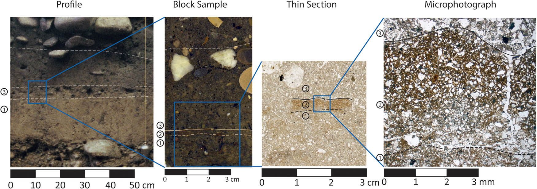
Different research scales in archaeological soil micromorphology at the Late Iron Age Site “Basel Gasfabrik” in Switzerland. The discontinuously preserved loam floor (2) is clearly visible in the micromorphological block sample, thin section, and microphotograph but remains hidden in the archaeological profile. Micromorphological analysis indicated that the floor was formed upon truncated flood plain deposits (1) and was covered by sediments interpreted as an outdoor walking surface (3). The microphotograph of the loam floor shows clear compaction of the former surface and distinctive horizontal cracks indicating trampling. It illustrates the lack of an occupation layer accumulated on the floor surface. The microphotograph was taken in plain polarised light.
In order to overcome these issues, we developed a two-pillar open access database, which we present here for the first time: “I-GEOARCHrec & I-GEOARCHive” (Figure 2).

Data recorded in Claris FileMaker database I-GEOARCHrec can be imported to the online tool I-GEOARCHive, where the information is linked to related pictures of different scales. The interface between the two databases is marked with the spiral-like symbol of the repository DaSCH.
2 I-GEOARCHrec: Overcoming Challenges in Recording and Sharing of Data
Throughout a micromorphological analysis of archaeological soil thin sections, thousands of observations are processed and recorded following standardised procedures (Bullock, Fedoroff, Jongerius, Stoops, & Tursina, 1985; Stoops, 2003, 2021). These data are often published in less standardised spreadsheets or through extensive descriptions (Kovács, Vicze, & Pető, 2023; Trebsche, Außerlechner, Cereda, Da Seidl Fonseca, & Staudt, 2023). In a recent publication, Marcazzan and Meinekat (2022) tried to meet the need for a standardised recording and publication template using the widely accessible Microsoft Word program. This template guides users through the complex recording process, allows the combination of micro-photographs and thin section scans with standardised recordings of observations, and is easy to share among scholars. However, Microsoft Word is not an appropriate format to compile and compare big data and is therefore limiting the possibilities of reusing archaeological soil micromorphological data. This is one of the main goals of I-GEOARCHrec, a Claris FileMaker database developed to record quantitative and qualitative data of micromorphologically analysed deposits and sediments based on Stoops (2003, 2021). This is, per se, nothing new as various similar templates and databases have previously been used in numerous research projects (e.g. Borderie, 2012; Brönnimann et al., 2020; Ismail‐Meyer, Vach, & Rentzel, 2020). However, most recording tools were developed for one specific site, researcher, or research questions but proved to be unsuitable for others. To overcome this issue, I-GEOARCHrec builds on these experiences and combines an extensive choice of descriptive parameters and various recording modes. The latter allows the quantification of parameters describing the micromorphologically studied layer or observed components, respectively (e.g. microartefacts like charcoal or bone fragments, coatings, and bioturbation features). “The database also allows the recording of taphonomic aspects, which are of increasing importance in (geo)archaeological research, to be recorded by default.”
For a better understanding of the different recording modes and descriptive parameters, the example of bone fragments is presented, as fragments and splinters of bones are frequently observed in archaeological layers and can exhibit many different taphonomic overprints. The quantification of bone fragments for each layer can be recorded nominally (present/absent), ordinally (categories; 0–6), and in an advanced list also metrically (percentage value or count value). In addition, a variety of quantitative information on the bone fragments such as size, preservation (fragmentation and roundness), heat traces, and geochemical processes (e.g. dissolution of collagen) can be described. Furthermore, object-specific information is also possible. For example, for bone fragments, the intensity and type of bioerosion (e.g. Wedl tunnels, microfocal destruction, and cyanobacteria tunnels) can be noted. To summarise, the strength of I-GEOARCHrec lies not only in the great depth of detail but also in the fact that users can determine the type and level of detail of the data recording themselves.
I-GEOARCHrec has already been used and tested by the authors and their students to improve and ensure its functionality and operability, and it can be downloaded on Zenodo: https://doi.org/10.5281/zenodo.10506793. An extensive manual describing exactly how components and features should be recorded is currently being finalised. This will further minimise the divergence of user backgrounds. Furthermore, all users are registered, and the traceability of entries is guaranteed in order to be able to compare recordings of different researchers with different background experiences. As a widely applicable recording tool, I-GEOARCHrec lays the groundwork for micromorphological data to be applied in comparative studies, statistical analysis, or synthesising visualisations. This achievement will considerably enhance the impact of micromorphology in archaeological research.
3 I-GEOARCHive: Storing and Contextualising Images as Primary Data in Micromorphology
Within the micromorphological community, there is a need to share not only standardised recordings of micromorphological observations but also image data (e.g. profile pictures, sample documentation, thin section scans, and microphotographs). I-GEOARCHive is an open-access online database of high-resolution images described with standardised keywords and short texts (Figure 3). It is possible to annotate these images and link them to close-ups, thin section scans, sample or profile pictures, and descriptions imported from I-GEOARCHrec (Figure 2).
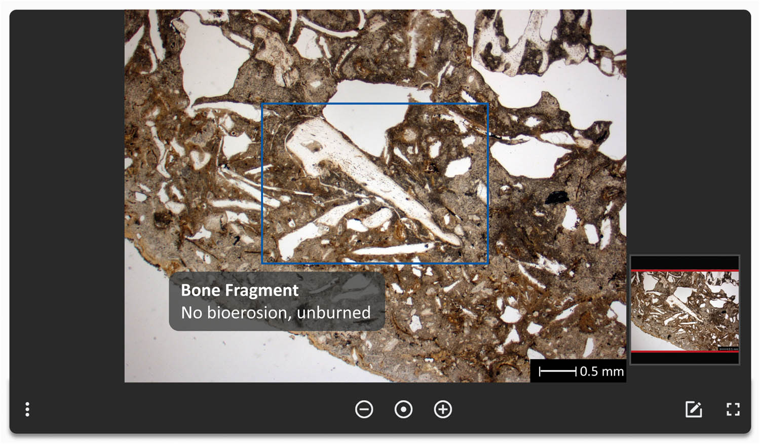
A preview of I-GEOARCHive database showing a microphotograph of a dog coprolite containing an unburned bone fragment without any traces of bioerosion. Annotations with further descriptions can be inserted within the illustration (blue rectangle with description).
I-GEOARCHive is hosted and continuously curated in accordance with FAIR principles (https://www.go-fair.org/) by DaSCH (https://www.dasch.swiss/). Further information on I-GEOARCHive (access and data structure) can be found in the following link: https://zenodo.org/records/10519439.
Moreover, the repository is compliant with the Open-Archival-Information-System archiving standard, therefore maintaining the provenience of data and guaranteeing its integrity. Each image and every dataset in the database have their own persistent identifier. Consequently, such image data are perfect for precise citation in scientific publications and serve as online references. Furthermore, date and user are recorded for each entry, contributing to a full history of each dataset. This comprehensive online tool is the first of its kind in archaeological soil and sediment micromorphology and is a valuable tool in disseminating micromorphological results, enabling accessibility of layer descriptions, thin section collections, and microphotographs for teaching and research. Although there are good reference books (e.g. Nicosia & Stoops, 2017; Stoops, Marcelino, & Mees, 2018; Verrecchia & Trombino, 2021), the digital archive has the advantage of filtering and searching for keywords, as well as displaying a large number of high-resolution photos. Furthermore, these image data are open access and hence widely applicable, including for deep learning or referenced mapping, two emerging techniques in our research field (Arnay, Hernández-Aceituno, & Mallol, 2021).
4 Conclusion
The two-pillar database allows micromorphologists to collect uniform data during thin-section analyses, archive image data and descriptive data, and link them to one another.
Beta versions of both databases, I-GEOARCHrec and I-GEOARCHive, are already in use within the research project “Welcome to the Dark Side” at the Vrije Universiteit Brussel and the University of Basel, as well as the research project “The Archaeology of Coastal Communities” at the Vrije Universiteit Brussel.
The database allows these projects to build on standardised data to answer overarching research questions and to explore new methods of statistical analysis and data visualisation (Figure 4).

Summarising workflow and visual manual for the use of the two-pillar database system. Once the data have been recorded using I-GEOARCHrec and I-GEOARCHive (step 1), they are linked to one another (step 2), creating new datasets allowing broader analytical approaches such as statistics and image analysis (step 3).
Furthermore, I-GEOARCHive offers a straightforward way of publishing big data (sets). Gradually, I-GEOARCHive shall become an important open access online tool and substantial digital reference collection (e.g. lakeshore settlements, human and animal coprolites, organic remains, floor sequences, and Dark Earth). Hence, the two-pillar database will be of great value both for future research and teaching and will open up new opportunities for micromorphologists and geoarchaeologists.
Acknowledgments
We thank Barbora Wouters for inspiring us to write this article and to Lizzie Wright for improving our English.
-
Funding information: This research was supported by a strategic research project funded by the Vrije Universiteit Brussel (grant no. SRP 64), Weave research project “Welcome to the Dark Side – Disclosing the Invisible Stages of Medieval Organization through the Integrated Study of European Dark Earths” funded by the Research Foundation – Flanders (FWO; grant no. FWOAL1057), the Swiss National Science Foundation (grant no. 205278), and the Department of Environmental Science of University of Basel.
-
Author contributions: K.N., P.R., K.I.-M., and R.G. provided funding. S.L.R., C.P., D.B., K.I.-M., P.R., J.W., and Y.D. contributed to the development of “I-GEOARCHrec”. R.G., D.B., S.L.R., C.P., K.I.-M., P.R., and Y.D. contributed to the development of “I-GEOARCHive”. C.P., D.B., and S.L.R. designed the figures. S.L.R. prepared the manuscript with contributions from all co-authors. The authors applied the SDC approach for the sequence of authors.
-
Conflict of interest: The authors state that there is no conflict of interest.
-
Data availability statement: Data sharing is not applicable to this article as no datasets were generated or analysed during the current study.
References
Arnay, R., Hernández-Aceituno, J., & Mallol, C. (2021). Soil micromorphological image classification using deep learning: The porosity parameter. Applied Soft Computing, 102, 107093. doi: 10.1016/j.asoc.2021.107093.Search in Google Scholar
Borderie, Q. (2012). Some quantitative aspects of thin section analysis for archaeological research. In R. M. Poch, M. Casamitjana, & M. L. Francis (Eds.), Proceedings of the 14th International Working Meeting on Soil Micromorphology: Lleida, 8-14, July 2012, Departament de Medi Ambient i Ciències del Sòl, Universitet de Lleida, Lleida, Spain (pp. 363–365). Lleida: Editions i Publications de la Universitat de Lleida.Search in Google Scholar
Brönnimann, D., Röder, B., Spichtig, N., Rissanen, H., Lassau, G., & Rentzel, P. (2020). The hidden midden: Geoarchaeological investigation of sedimentation processes, waste disposal practices, and resource management at the La Tène settlement of Basel‐Gasfabrik (Switzerland). Geoarchaeology. Advance online publication. doi: 10.1002/gea.21787.Search in Google Scholar
Bullock, P., Fedoroff, N., Jongerius, A., Stoops, G., & Tursina, T. V. (1985). Handbook for soil thin section description. Albrighton: Waine Research.Search in Google Scholar
Goldberg, P. (2008). Raising the bar: Making geological and archaeological data more meaningful for understanding the archaeological record. In A. P. Sullivan (Ed.), Foundation of archaeological inquiry. Archaeological concepts for the study of the cultural past. Salt Lake City, Utah: Univ. of Utah Press.Search in Google Scholar
Goldberg, P., & Aldeias, V. (2018). Why does (archaeological) micromorphology have such little traction in (geo)archaeology? Archaeological and Anthropological Sciences, 10(2), 269–278. doi: 10.1007/s12520-016-0353-9.Search in Google Scholar
Ismail‐Meyer, K., Vach, W., & Rentzel, P. (2020). Do still waters run deep? Formation processes of natural and anthropogenic deposits in the Neolithic wetland site Zug‐Riedmatt (Switzerland). Geoarchaeology, 35(6), 921–951. doi: 10.1002/gea.21796.Search in Google Scholar
Kovács, G., Vicze, M., & Pető, Á. (2023). Fires of a house—Burning events in a Middle Bronze Age Vatya house as evidenced by soil micromorphological analysis of anthropogenic sediments. Land, 12(1), 159. doi: 10.3390/land12010159.Search in Google Scholar
Lewis, H. (2023). Archaeological soil micromorphology. In A. M. Pollard, R. A. Armitage, & C. Makarewicz (Eds.), Handbook of archaeological sciences (pp. 253–269). Hoboken, NJ: Wiley. doi: 10.1002/9781119592112.ch13.Search in Google Scholar
Lo Russo, S., Brönnimann, D., Devos, Y., Ismail-Meyer, K., Pümpin, C., Rentzel, P., & Wouters, B. (2024). I-GEOARCHrec. Zenodo. doi: 10.5281/zenodo.10506793.Search in Google Scholar
Macphail, R. I. (2014). Archaeological soil micromorphology. In Encyclopedia of global archaeology (pp. 356–364). New York, NY: Springer. doi: 10.1007/978-1-4419-0465-2_227.Search in Google Scholar
Marcazzan, D., & Meinekat, S. A. (2022). Creating qualitative datasets in geoarchaeology: An easy-applicable description template for archaeological thin section analysis using Stoops 2003. MethodsX, 9, 101663. doi: 10.1016/j.mex.2022.101663.Search in Google Scholar
Nicosia, C., & Stoops, G. (Eds.). (2017). Archaeological soil and sediment micromorphology. Hoboken: Wiley Blackwell.10.1002/9781118941065Search in Google Scholar
Nikita, E., Mardini, M., Mardini, M., Tsimopoulou, C., & Karligkioti, A. (2021). Bi(bli)oArch: An open-access bibliographic database for human bioarchaeological studies in the Eastern Mediterranean and Middle East. Journal of Archaeological Science: Reports, 39, 103151. doi: 10.1016/j.jasrep.2021.103151.Search in Google Scholar
Stoops, G. (2003). Guidelines for analysis and description of soil and regolith thin sections. Madison: Soil Science Society of America.Search in Google Scholar
Stoops, G. (2021). Guidelines for analysis and description of soil and regolith thin sections (2nd ed.). ASA, CSSA, and SSSA Bks. Newark: American Society of Agronomy.10.1002/9780891189763Search in Google Scholar
Stoops, G., Marcelino, V., & Mees, F. (Eds.). (2018). Interpretation of micromorphological features of soils and regoliths (2nd ed.). Amsterdam, Netherlands: Elsevier.Search in Google Scholar
Trebsche, P., Außerlechner, M. V., Cereda, S., Da Seidl Fonseca, H., & Staudt, M. (2023). A fluctuating environment: Micromorphological and archaeobotanical investigations of the early Iron Age Lakeshore settlement at Traunkirchen (Upper Austria). Environmental Archaeology, 1–21. doi: 10.1080/14614103.2023.2176611.Search in Google Scholar
Verrecchia, E. P., & Trombino, L. (2021). A visual atlas for soil micromorphologists (1st ed.). Springer eBook Collection. Cham: Springer Nature. doi: 10.1007/978-3-030-67806-7.Search in Google Scholar
© 2024 the author(s), published by De Gruyter
This work is licensed under the Creative Commons Attribution 4.0 International License.
Articles in the same Issue
- Regular Articles
- Social Organization, Intersections, and Interactions in Bronze Age Sardinia. Reading Settlement Patterns in the Area of Sarrala with the Contribution of Applied Sciences
- Creating World Views: Work-Expenditure Calculations for Funnel Beaker Megalithic Graves and Flint Axe Head Depositions in Northern Germany
- Plant Use and Cereal Cultivation Inferred from Integrated Archaeobotanical Analysis of an Ottoman Age Moat Sequence (Szigetvár, Hungary)
- Salt Production in Central Italy and Social Network Analysis Centrality Measures: An Exploratory Approach
- Archaeometric Study of Iron Age Pottery Production in Central Sicily: A Case of Technological Conservatism
- Dehesilla Cave Rock Paintings (Cádiz, Spain): Analysis and Contextualisation within the Prehistoric Art of the Southern Iberian Peninsula
- Reconciling Contradictory Archaeological Survey Data: A Case Study from Central Crete, Greece
- Pottery from Motion – A Refined Approach to the Large-Scale Documentation of Pottery Using Structure from Motion
- On the Value of Informal Communication in Archaeological Data Work
- The Early Upper Palaeolithic in Cueva del Arco (Murcia, Spain) and Its Contextualisation in the Iberian Mediterranean
- The Capability Approach and Archaeological Interpretation of Transformations: On the Role of Philosophy for Archaeology
- Advanced Ancient Steelmaking Across the Arctic European Landscape
- Military and Ethnic Identity Through Pottery: A Study of Batavian Units in Dacia and Pannonia
- Stations of the Publicum Portorium Illyrici are a Strong Predictor of the Mithraic Presence in the Danubian Provinces: Geographical Analysis of the Distribution of the Roman Cult of Mithras
- Rapid Communications
- Recording, Sharing and Linking Micromorphological Data: A Two-Pillar Database System
- The BIAD Standards: Recommendations for Archaeological Data Publication and Insights From the Big Interdisciplinary Archaeological Database
- Corrigendum
- Corrigendum to “Plant Use and Cereal Cultivation Inferred from Integrated Archaeobotanical Analysis of an Ottoman Age Moat Sequence (Szigetvár, Hungary)”
- Special Issue on Microhistory and Archaeology, edited by Juan Antonio Quirós Castillo
- Editorial: Microhistory and Archaeology
- Contribution of the Microhistorical Approach to Landscape and Settlement Archaeology: Some French Examples
- Female Microhistorical Archaeology
- Microhistory, Conjectural Reasoning, and Prehistory: The Treasure of Aliseda (Spain)
- On Traces, Clues, and Fiction: Carlo Ginzburg and the Practice of Archaeology
- Urbanity, Decline, and Regeneration in Later Medieval England: Towards a Posthuman Household Microhistory
- Unveiling Local Power Through Microhistory: A Multidisciplinary Analysis of Early Modern Husbandry Practices in Casaio and Lardeira (Ourense, Spain)
- Microhistory, Archaeological Record, and the Subaltern Debris
- Two Sides of the Same Coin: Microhistory, Micropolitics, and Infrapolitics in Medieval Archaeology
- Special Issue on Can You See Me? Putting the 'Human' Back Into 'Human-Plant' Interaction
- Assessing the Role of Wooden Vessels, Basketry, and Pottery at the Early Neolithic Site of La Draga (Banyoles, Spain)
- Microwear and Plant Residue Analysis in a Multiproxy Approach from Stone Tools of the Middle Holocene of Patagonia (Argentina)
- Crafted Landscapes: The Uggurwala Tree (Ochroma pyramidale) as a Potential Cultural Keystone Species for Gunadule Communities
- Special Issue on Digital Religioscapes: Current Methodologies and Novelties in the Analysis of Sacr(aliz)ed Spaces, edited by Anaïs Lamesa, Asuman Lätzer-Lasar - Part I
- Rock-Cut Monuments at Macedonian Philippi – Taking Image Analysis to the Religioscape
- Seeing Sacred for Centuries: Digitally Modeling Greek Worshipers’ Visualscapes at the Argive Heraion Sanctuary