Applications of virtual reality technology on a 3D model based on a fuzzy mathematical model in an urban garden art and design setting
-
Dong Sui


Abstract
In the framework of an urban garden art and design environment, this research examines the integration of virtual reality (VR) technology with a 3D model built using a fuzzy mathematical model. The goal is to provide a cutting-edge, immersive experience that enables people to engage with and explore the subtleties of a distinctive urban garden setting by fusing creative components with outdoor areas. Our proposed, advanced genetic algorithm-based fuzzy logic mathematical model effectively addressed the challenges in urban gardens by providing innovative design solutions that optimized space, efficiently managed resources, and fostered community engagement, ensuring produce safety, health, and the vitality of the garden. Raw data were collected, and then the data were involved in the pre-processed used min-max normalization. Next feature extracts the data using principal component analysis. The research findings should be presented, together with information on how well VR technology and a fuzzy mathematical model worked to produce the intended aesthetic results. It also describes how the research can be used for VR, urban garden design, and art. The findings demonstrate that VR technology gives designers actual impacts of information processing via complete presentation, intelligent drawing, and timely information, which significantly boosts design productivity and successfully encourages design quality and fitness rate accuracy. Additionally, two benchmark datasets were used for comparison, and our proposed method achieved an accuracy of 98.8%. The research expands the possibilities for artistic expression and strengthens the connection between people and urban green areas.
1 Introduction
Natural and intuitive real-time perceptions and interactions are provided by virtual reality (VR) technology, enhanced using a computer interface that makes it simple for people to operate systems and increase system productivity. The development and use of this technology have fundamentally altered the way that designs are made, giving designers actual data processing impacts via intelligent drawing, considerably increasing design quality while efficiently increasing design efficiency. In order for professionals to instinctively efficiently notice the test outcomes or execute interactive operations based on the outcomes, 3D graphic technology uses envisioned images to depict numbers and computation outcomes and conveys a vast quantity of information quickly using images [1]. The use of designing environmental art using VR can not only aid in better global opportunity exploration but also motivate creators to produce original concepts and advancements in an interactive environment in addition to creative designs and instruments. From a design’s original idea to its ultimate effect, its rich creative expression is effective. Despite the fact that the use of current VR technology in environmental art design is still being researched and developed, it is certain that as technology advances, so will its importance and effect. By combining data from many sensors, VR technology can significantly increase the accuracy of position modeling and computations [2]. The truth, which is reality 3D geometric space, has its own three-dimensional spatial information that any creature can access. To describe and interpret the 3D data of urban space, it is required to build a model of the city’s landscape in 3D. To accommodate consumers’ requirements and rapid urbanization, commercial complexes might provide more practical, concentrated living spaces [3]. Geographic information systems and contemporary computer technologies, remote sensing, VR, and other technologies are the foundation of the urban environment design visualized in 3D. It tightly integrates the planning and management of business activities on the foundation of the creation of a fundamental 3D model information database. Urban landform simulators enable automated, scientific dynamic planning, ensures timely information updates, efficiently carry out geographical analysis of regional data, encourage a regional strategy depth, and have clear financial, social, and environmental advantages for urban development and administration [4]. The area of contemporary urban garden landscape design calls for designers with an ever-increasing breadth of knowledge, and the actual job often calls for expertise in a variety of fields, including horticulture, aesthetics, and natural biology. In order for the restricted garden landscape area to exert maximum efficacy and provide urban dwellers with a fresh visual experience, designers must fully use creative thinking and include novel components. Some of the key elements in the whole design process are the choice of the urban garden landscape location [5]. Urban people’s requirements for both material and spiritual life are met by incorporating the terrain’s peaks and valleys into the design and incorporating contemporary artistic elements into the small garden landscape area. This allows for the cultivation of urban residents’ spirituality and the coordinated development of ecological, social, and financial rewards [6]. The fact that the 3D model is based on a fuzzy mathematical framework suggests that the simulation is based on shaky or ambiguous data opens the door for organic and dynamic modifications to the virtual world. This might imply that random elements have an impact on the plants, landscapes, and weather, giving the game a more realistic and unpredictable feel. Users can use VR headsets or other immersive devices to engage with the environment in this garden-themed VR environment, wander around the trails, and see numerous artworks. Additionally, they can alter garden aspects such as sculpture placement, sunshine control, and even the introduction of new plant species to see how they interact with one another [7]. The model can use fuzzy sets to classify plants according to whether or not they are suitable for certain garden regions. The model can employ fuzzy membership functions to describe various levels of appropriateness rather than categorizing plants strictly as “sun-loving” or “shade-loving.” This adaptability allows designers to produce a landscape that is more diversified and robust, better equipped to cope with shifting environmental circumstances over time [8]. Furthermore, subjective elements such as aesthetics and emotional reactions can also be taken into consideration by fuzzy mathematical models. Designers can include linguistic factors that correspond to how people would perceive a garden’s harmony, attractiveness, or tranquillity [9]. In this approach, the garden’s entire atmosphere and ambiance can be better captured by the model, which can then be used to improve the design [10]. This research analyzes and summarizes the current state of research on 3D visualized urban garden design and planning, and discusses the ramifications of this trend. It also expands the advancement background, current status, and upcoming difficulties associated with VR technology, introduces the principles and techniques for building a 3D scene model and database of urban garden landscapes, with 3D visualizations for urban planning and analysis and assessment indication screening and system.
Contributions of the research
The main contributions of the research urban garden landscape-based data are gathered.
The pre-processed approach using Min-Max normalization was applied to the data, and features were extracted using principal component analysis (PCA).
The difficulties faced by urban gardens were successfully addressed by our suggested advanced genetic algorithm-based fuzzy logic mathematical model (AGA-FLMM) method, which offered creative design solutions that maximized space, effectively managed resources, and encouraged community involvement, guaranteeing the safety, health, and produce energy.
This component places special emphasis on how the models and technologies are really used in an urban garden. Investigating how VR, 3D modeling, and fuzzy mathematical modeling can be specially used to improve the aesthetic and design elements of urban garden settings is the contribution. This could take into account factors such as aesthetics, usability, sustainability, and user experience.
The rest of the research organization is as follows: related works are described in Section 2, the proposed methods are presented in Section 3, the results and discussion are described in Section 4, and the conclusion of the research is presented in Section 5.
2 Related works
In this section, the research discusses urban garden art and design setting using related studies. Table 1 depicts the related works.
Related works
| References | Objectives | Summary of the finding |
|---|---|---|
| [11] | The research examined how public artworks interact with their contexts and have changed throughout time. After implementing the virtual process using a variety of collaboration tools, the actual requirements of 3D virtual reconstruction were analyzed. An evolutionary algorithm-based space environment design method was also suggested | The layout of this page has positively impacted locals’ scores, indicating the feasibility of a strategy that involved a public art and urban space design for city development |
| [12] | The research offered an agent model connected to machine learning time granularity, examined its timeliness, and defined simulated machine learning time granularity. Construction of a real-time simulation time administration structure and research on switching real-time assurance, message exchanges, and temporal granularity in machine learning | The research discussed the challenges and new approaches to parametric structure and digital geometric algorithms in garden design that highlighted the advantages and drawbacks of the Grasshopper parameter platform, which showcases its sophisticated, logical, and scientific nature in real project design |
| [13] | The research concluded that urban gardens and other vegetated areas need sophisticated irrigation systems to manage water needs and resource availability. The research presented a Smart City smart irrigation system communication protocol. Wireless devices utilizing WiFi and LoRacan communicate using the protocol | Low-cost instruments were used in city tests, revealing a successful approach to transmit messages from WiFi to LoRa, preventing packet loss by adding a 500 ms delay at the CH node |
| [14] | The research employed a 3D image processing method for landscape design, pre-processing 3D landscape images to eliminate noise and overlapping information, and utilizing a feature enrichment technique to enhance clarity and detail | The discoveries demonstrated that the system’s design impact was quite distinct and of high quality. It receives good marks for the layout of the courtyard and garden, as well as the system’s low application costs, lowest energy use, and effective operation |
| [15] | The research to visualize the stems and limbs of fruit trees is based on their morphological feature data and the parameter L system. It extracts morphological, structural, ecological, and physiological traits from the pear tree’s structure. The L-system modeling approach uses branch thickness, bifurcation angle, and other factors to create a 3D visual graphic data, establishing a framework for creating a pear tree shape | The research explored the basic theory of virtual plants; classified computer simulations based on plant descriptions, modeling goals, and template functions; and provided an overview of virtual crops in software implementation today. It also discussed virtual crop models |
| [16] | The research simulated a signal detection-based visualization system for urban ecological landscapes, using computer vision principles for image capture, migration, and examination | The visualization system of the urban environmental country side can be shaped using relevant technologies and united with the smart metropolis structure to create an all-encompassing city data mock-up that can be used to solve traffic, ecology, and other issues and achieve landscape advancement |
| [17] | The research developed a framework for evaluating physical, social, and psychological wellness in older persons, revealing that while most research focuses on physical health, it also aims to improve psychological well-being | The critical assessment method that was used in the research to identify the research requirements also suggests a plan for augmented reality (AR) and VR research in the future to look at this group. This research examined design strategies for VR and AR for the elderly by outlining challenges and design issues that arose throughout the critical evaluation |
| [18] | The research explored the relationship between emotional perceptions and visual cognition in traditional Jiangnan garden architecture using VR simulations. By analyzing data from visit techniques, questionnaires, and behavioral observations, the research identifies how spatial qualities such as openness, complexity, and theatricality influence emotions such as calmness, surprise, interest, and confusion | The findings provide a quantitative understanding of how these gardens evoke emotional responses, offering valuable insights for applying traditional spatial features to contemporary architecture. The research bridges subjective sensory experiences with rational analysis, enhancing our comprehension of Jiangnan gardens’ spatial narratives |
| [19] | The research suggested that landscape designers should be proficient using computer-aided design tools, which serve as visual representations of their ideas. Modern landscape design professors should focus on teaching learners how to effectively use these tools in landscape design | A brief overview of the system’s main functions is followed by an in-depth analysis of the simulation technique used in the professional module. The system’s effectiveness was verified using an engineering example |
| [20] | The research utilized campus plant species, virtual breeding operations, AR, and mobile learning technology to create virtual butterfly ecological systems, allowing learners to observe butterfly life stages | The problems of insufficient butterfly diversity and quantity can be resolved by the virtual butterfly ecological system, which was easier to establish and maintain than real butterfly gardens |
| [21] | The research examined the application of VR technology in landscape planning and design to reduce the impact on landscape greening. It involves creating realistic 3D landform character models using grid-based structures and texture mapping | The A* algorithm is used to determine the optimal path for a smoother, more realistic movement through the landscape. The results demonstrate improved visual clarity, more immersive roaming, and efficient landscape design with minimized environmental impact |
| [22] | The research aimed to understand the instructional structure for research plants in higher education in art and design by examining plant themes in street art and design objects in India. The research’s visual ethnography had theoretical implications for public education about plants | The research highlighted the importance of plants in public pedagogy curriculum, highlighting their historical and cultural significance, and their diverse use and reasons for public display |
| [23] | The research explored the complexity, diversity, and variability of ecological environmental issues, particularly water pollution, by examining the use of a specific location’s ecological landscape | The application of ecological ideas in urban garden planning can enhance living conditions, prevent environmental damage, and minimize natural resource usage |
| [24] | The research enhanced 3D animation through VRML by improving character effects, interactivity, and visual quality. Methods include texture mapping, optimized lighting, scripting (Java, JavaScript, VRML Script), and fuzzy model recognition to identify multimedia elements and boost frame rates | Results show consistent real-time performance with frame rates above 40 FPS in a virtual museum scene, maintaining visual quality and system responsiveness. However, the full potential of VR animation depends on long-term collaboration across disciplines and may face challenges with scalability and content complexity |
| [25] | The research explores the use of VR technology integrated with GIS data fusion in elementary school mathematics education. Using case analysis of three systems virtual experimental teaching, intelligent auxiliary teaching, and virtual classroom, the research combines investigation and experimental methods to assess effectiveness | Results show that 78 students found VR helpful for simulating operations and understanding principles, with over 50% reporting increased interest in learning. Despite its promising findings, the research is limited by sample size and lacks long-term impact evaluation |
2.1 Research gap
The existing research on urban garden design and VR integration provides valuable insights into various aspects, such as resource optimization, ecological management, and emotional responses in virtual environments. However, there is a notable gap in exploring the intersection of immersive VR technology and advanced fuzzy logic models specifically tailored for urban garden art and design. While VR has been utilized for spatial visualization and community engagement, there is limited research on its application in the creation of sustainable, resource-efficient, and aesthetically impactful urban garden environments. More studies focus on isolated components such as irrigation systems, 3D modeling, or emotional responses, yet a holistic framework that combines these elements with real-time, adaptive VR-based design remains largely unexplored. The research integration of AGA-FLMM for optimizing garden spaces and fostering community interaction remains underexplored, which should focus on developing comprehensive models that address these gaps, enabling a more immersive, sustainable, and user-centric approach to urban garden design.
3 Methodology
In this section, the integration of an AGA-FLMM in the context of urban garden art and design setting facilitates an innovative and optimized design solution that promotes an efficient resource management, enhancing aesthetic appealing. Figure 1 depicts the flow of the proposed work.
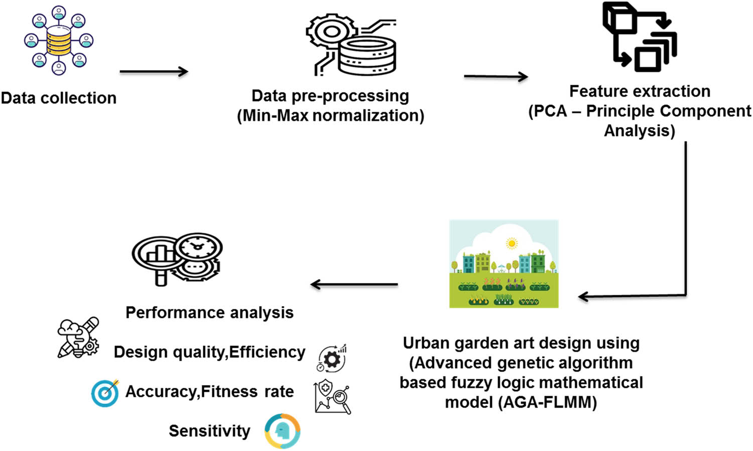
Flow of the proposed method.
3.1 Data collection
Dataset 1 (https://www.kaggle.com/datasets/ziya07/urban-green-space-model-data/data), the Urban Green Space (UGS) Model Data, offers a comprehensive collection of urban garden and landscape layout plans. It includes high-resolution 2,000 × 2,000 px JPEG images of garden blueprints and design metadata that detail plant species, object placements, and terrain. This dataset is valuable for advanced modeling, simulation tasks, and urban planning using AI-driven techniques, 3D modeling, and VR environments. Dataset 2 (https://www.kaggle.com/datasets/ziya07/garden-space-planning-data/data), “Garden Space Planning Data,” is a curated collection of high-resolution urban garden landscape plans (2,000 × 2,000 px) in JPEG format. This dataset is designed to support research and development in areas such as 3D modeling, VR simulation, and fuzzy logic-based design optimization. It provides essential resources for designing smart, sustainable, and visually engaging green spaces in urban environments, contributing to the advancement of urban planning and landscape design techniques. The data for the research were gathered from (https://www.kaggle.com/datasets/zoya77/3m-urban-blue-green-gray-dataset) website. UBGG-3m (Urban Blue-Green-Gray 3-meter) dataset is a high-resolution urban landscape resource developed to address the lack of fine-grained urban landscape data. It focuses on classifying urban areas into three primary categories: Urban Blue Spaces, which include water bodies such as rivers, lakes, and ponds; UGS, which encompass vegetation areas such as trees, grasslands, and farmlands; and Urban Impervious Surfaces, which are man-made structures such as buildings, roads, and pavements. This dataset provides valuable insights into the composition of urban landscapes, aiding in urban planning, environmental sustainability efforts, and the assessment of ecosystem services, such as water management, green space availability, and urban heat island effects. By offering high-resolution data, UBGG-3m supports detailed analysis and decision-making for sustainable urban development.
3.2 Data pre-processing using min-max normalization
Min-max normalization is often used to scale numerical properties within a certain range. In machine learning, it is often used to prepare data for models. To improve diabetes prediction accuracy, min-max normalization can be used to the dataset’s input features. To compare results fairly before and after normalization, min-max normalization makes linear adjustments to the original data.
3.3 Data feature extraction using PCA
To reduce urban data dimensionality while preserving key information, PCA is applied. PCA helps eliminate redundancy, reduce noise, and transform correlated evaluation indices into a smaller set of uncorrelated principal components, thus enhancing urban landscape garden design data interpretability without significant information loss.
Let the evaluation data matrix be defined as follows:
where B is the number of observation samples (e.g., different sporting events), A is the number of original evaluation indices (e.g., crowd size, weather conditions, and injury rates), and E ji is the value of the ith index in the jth sample.
The score for the jth observation on the ith principal component is given as follows:
where
Compute the correlation matrix
where
Once principal components are extracted, the overall risk rating
where
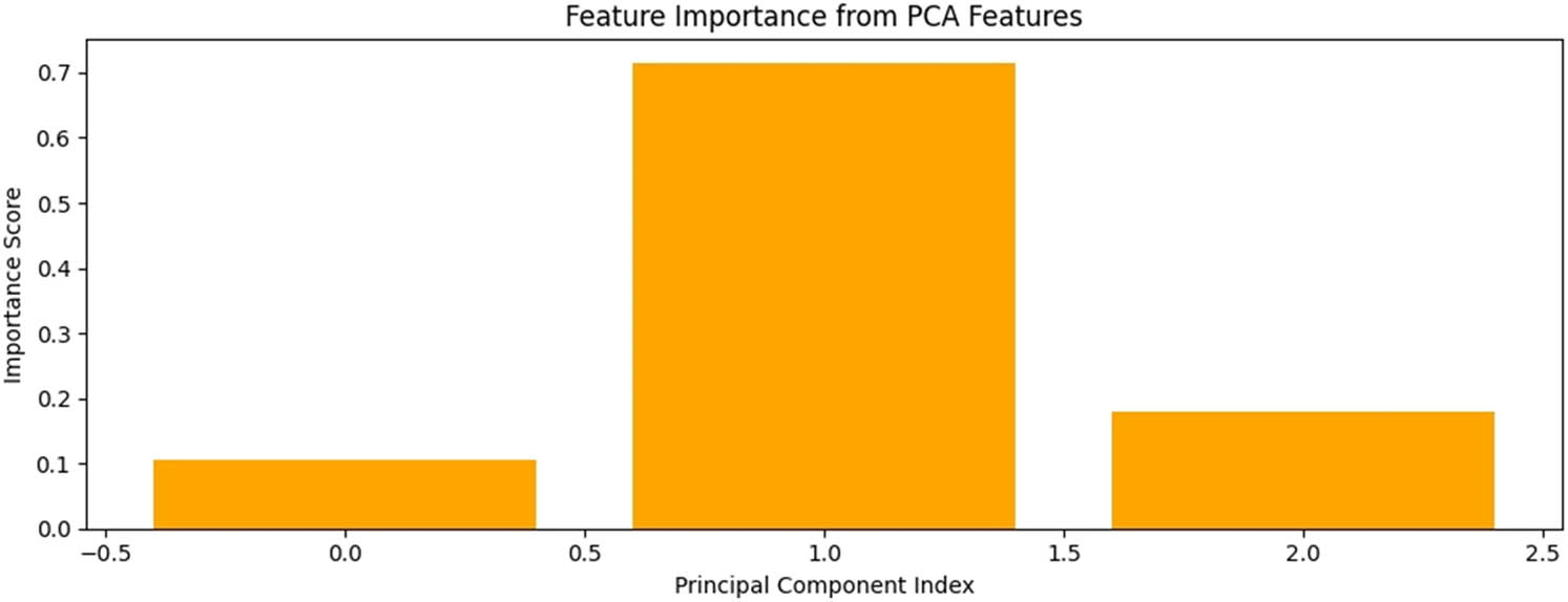
Feature importance from PCA features.
Design quality in this context is typically assessed using algorithmic benchmarks rather than purely subjective user ratings. PCA, as visualized in the provided image, reduces dimensionality by identifying components that explain the most variance in the dataset. The bar plot indicates the relative importance of each principal component. In this example, the first component (index ∼1) has the highest importance score, contributing over 70% to the model’s predictive power. This suggests that the features most aligned with this component are key contributors often capturing dominant trends or correlations in the data. These might include composite measures of performance, structural integrity, or thermal efficiency, depending on the domain. Such insights allow for refining feature selection and improving model sensitivity and robustness.
3.4 AGA-FLMM
3.4.1 Fuzzy mathematical model of urban garden
The fuzzy logic system in the research was tuned using a combination of real-world urban garden data and parametric L-systems, which modeled plant structures based on ecological and aesthetic parameters. While the system primarily relied on deterministic rules, it incorporated fuzzy membership functions to assess plant suitability and aesthetic values (e.g., harmony, tranquillity) across garden zones. Validation was achieved through comparative analysis against existing models (convolutional neural network [CNN], decision tree [DT], support geographic regression [SGR]), demonstrating superior performance in accuracy, efficiency, and design quality, indicating effective tuning to real-world urban garden scenarios.
Urban Garden design has not had a particularly united and authoritative description in the academic world due to its complexity and variety. The landscape itself has both geographical and biological characteristics. Geographically speaking, the whole terrain, including topography and landforms, is given greater consideration. Accordingly, planning and designing a garden landscape are regarded as “complex objects on the land.” From an ecological perspective, more emphasis is placed on the coexistence and connection among it is more likely to regard the landscape as a self-circulating biological system since it includes both plants and nonplants. Landscape in a garden represents what is meant by “visual aesthetics,” which is the same as “landscape.” The literary and artistic communities, as well as a large number of landscape architects, are aware of its connotation.
The vegetation in the city garden is used as an example in the research fuzzy mathematical modeling. The Lindenmayer system (L-system) initials and products are characterized by strings, as can be observed from the idea of string replacement. While Formal languages, known as L-systems, everything comes down to that. Every letter in L-system must be given a distinct geometrical interpretation to tie it to the plant simulation and allow it to reflect the structure of actual plant branches. The idea of a turtle’s form can be used to convey it clearly. Postprocessing often involves PS software, followed by the printing of the renderings on a color laser printer.
The L-system’s perception of a turtle may be expanded from a 2D to a 3D space. First, the turtle shape’s current direction is described by three vectors: G, K, and V. They each stand for the turtle’s upward, left, and forward orientations. The following equation is satisfied by them since they are all unit lengths, perpendicular to one another.
The research simulates urban garden vegetation using formal language techniques, particularly the Lindenmayer system (L-system), which is widely used for modeling plant growth patterns. An L-system defines strings over an alphabet of symbols, where each symbol corresponds to a specific geometric operation. To realistically render plant structures, we use turtle geometry to interpret these symbols as drawing commands. In 3D space, the turtle’s orientation is defined by three orthogonal unit vectors:
The following equation can be used to depict the spinning turtle shape:
where
Similar matrices
As an ordered quaternion, example of a completely arbitrary L-system:
An elementary random L-system is as follows:
The most fundamental idea of parallel rewriting is expanded by the parameter L-system from words with simple characters to words with parameters. On terms that are module strings, such as parameters made up of characters containing parameters, the parameter L-system works. Arguments and characters both belong to the real number set
A parametric L-system enhances this structure by allowing each symbol (called a module) to carry numerical parameters. The set of all modules is defined as follows:
Each module is a part of the following collection:
where
with
The fuzzy system in the research uses fuzzy membership functions and linguistic variables (e.g., “sun-loving,” “shade-tolerant”) to classify plant compatibility based on environmental factors such as sunlight, soil, and spatial arrangement. Instead of rigid classifications, it assigns degrees of suitability, allowing for more nuanced and adaptable garden designs that can respond to variable and uncertain real-world conditions.
3.4.2 Advanced genetic algorithm
A kind of randomized search algorithm called a genetic algorithm is one that depends on the genetics and natural selection of creatures. More suitable personalities are chosen from the problem-solving groups using some metric. To create newer generations of potential answers, each person is merged by genetic operators. This procedure is continued before the convergence index is reached. The four major parts of a genetic algorithm are control parameters: selection, crossover, variation genetic operators, and coding technique. When an issue is solved using a genetic algorithm, the potential answers are encoded into chromosomes or people. An early problem-solving group is made up of several people. After determining the fitness function, the algorithm can be terminated by printing the persons who meet the termination requirements. If not, people will mix with each other, change, and recombine to create the following new population. The preceding generation’s positive traits are passed down to the next population, which is superior to it, allowing for a more favorable outcome to eventually emerge. The following are some examples of the genetic algorithm’s steps.
3.4.2.1 Creating the first population and coding
Select the suitable coding method for the given trouble. And make a populace of
3.4.2.2 Calculating fitness value
Each chromosome’s fitness
Determine whether the convergence need is met. With the output explore outcomes, continue with the next steps.
3.4.2.3 Choose action
According to each person’s fitness, the chance of selection is determined as follows:
To create the new population in the next-generation population, a random sample of the probability distributions mentioned earlier is taken from the
3.4.2.4 Cross-action
A collection of
3.4.2.5 Operation of mutation
Use a lower probability
| Algorithm 1: Advanced Genetic Algorithm |
|
Step 1: Create an n-chromosome population of random kind
|
|
Step 2: Fitness estimation for each chromosome x’s fitness
|
| Step 3: Iterate the following processes until you reach the new required population. |
|
| Step 4: Utilize freshly created population in a subsequent algorithm run. |
| Step 5: If the criteria for termination are met, stop the procedure and provide the best response from the current group of people. |
| Step 6: Step 2 is next. |
Urban garden planning and designing a landscape is a comprehensive procedure that begins with the gathering of the fundamental data needed for planning, continues with the creation of detailed design plans, and ends with the execution of the design on the substance of the planning. Planning objectives and planning pointers into physical places is the process of creating urban planning, which forms the basis of all other planning and design work. The system’s most important features are security and dependability. These features effectively ensure the integrity and security of the system’s data. The proposed system can be adapted for different climatic zones, cultural aesthetics, or ecological requirements. The integration of VR and the AGA-FLMM allows for flexible design solutions. By adjusting the parameters and models based on local climate, cultural preferences, and ecological needs, the system can offer tailored, context-specific urban garden designs that optimize space usage, resource management, and community engagement while ensuring environmental and aesthetic relevance.
A number of models can be automatically built in the 3D scene based on the urban garden landscape design’s chosen area’s landscape (Figure 3). This additionally offers a quick and easy way to generate models, but it can also be used to evaluate models created manually by other designers. The planner can change the chosen model’s size, orientation, coordinates, and other characteristics, as well as completely swap out the chosen model. This gives designers an opportunity for horizontal and vertical comparison, enabling them to choose their perfect strategy. The place is chosen in the planning interface using the landscape models’ replacements and modification functions.
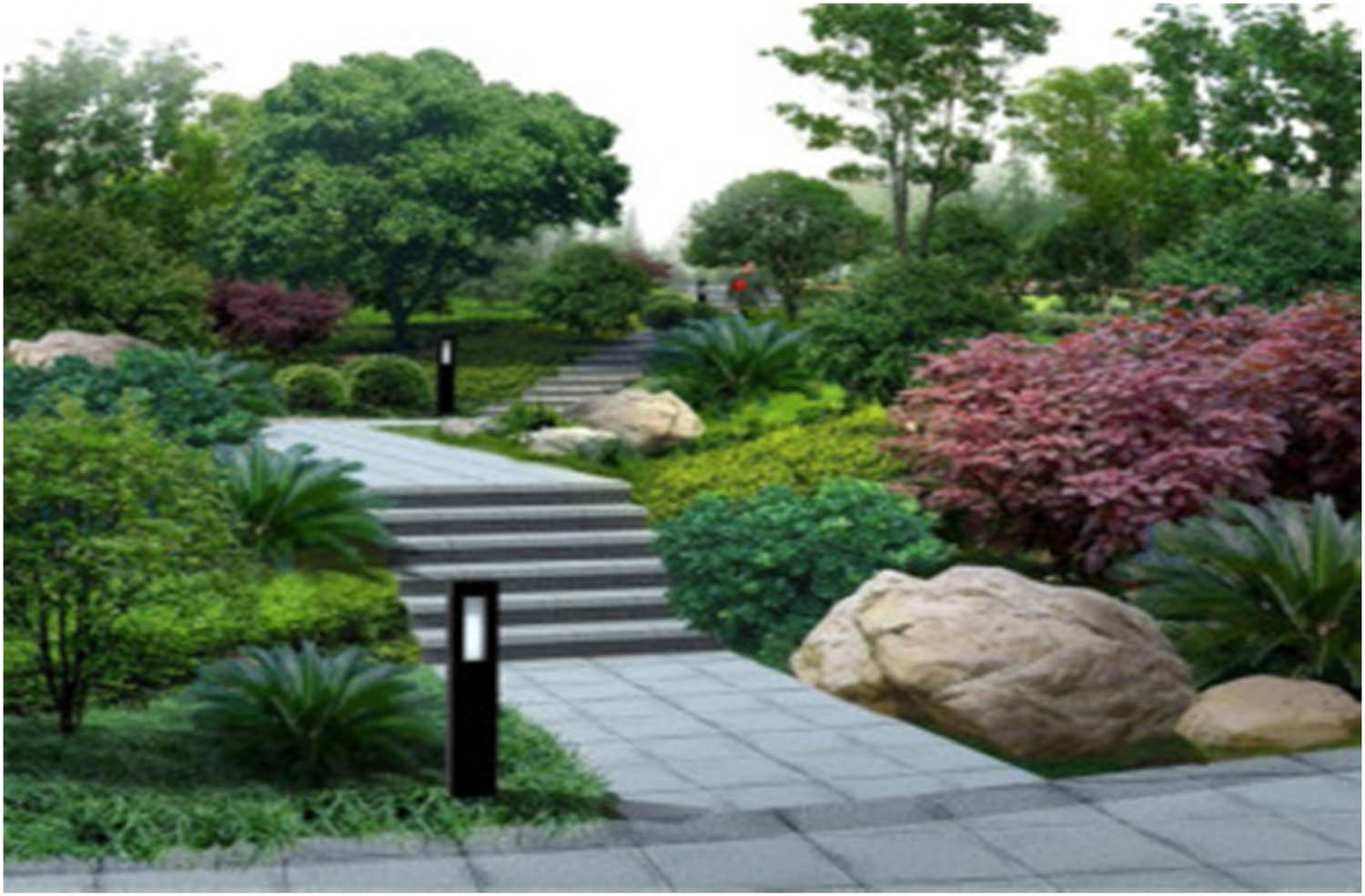
Using VR technology, a 3D virtualized urban garden landscape design was created (source: https://www.sciencedirect.com/science/article/abs/pii/S2352186421003862).
4 Results and discussion
This section explores the use of VR technology on a 3D model created using a fuzzy mathematical model in an urban garden art and design context. The researchers employed DT, CNN, and SGR to compare existing approaches [26]. An Intel core i7 CPU Windows 11 Python 3.8 32 GB RAM Jupyter Notebook also has a 1TB SSD, guaranteeing express and successful storage. The parameters include design quality, design efficiency, accuracy, prediction, sensitivity, and fitness rate.
4.1 Distribution of aesthetic scores
The histogram displays the distribution of aesthetic scores across a dataset, with most samples clustering near the mean around zero. This bell-shaped pattern suggests a roughly normal distribution, indicating balanced evaluations of design aesthetics. These scores are likely derived from either algorithmic model trained on annotated datasets or user rating aggregation, depending on the methodology. Figure 4 shows the presence of scores across a broad range from approximately −1.2 to 1.2, which implies sensitivity to diverse design attributes. While subjective ratings can influence initial training, the final assessment is often quantitatively modelled to ensure consistency, objectivity, and scalability across large datasets.
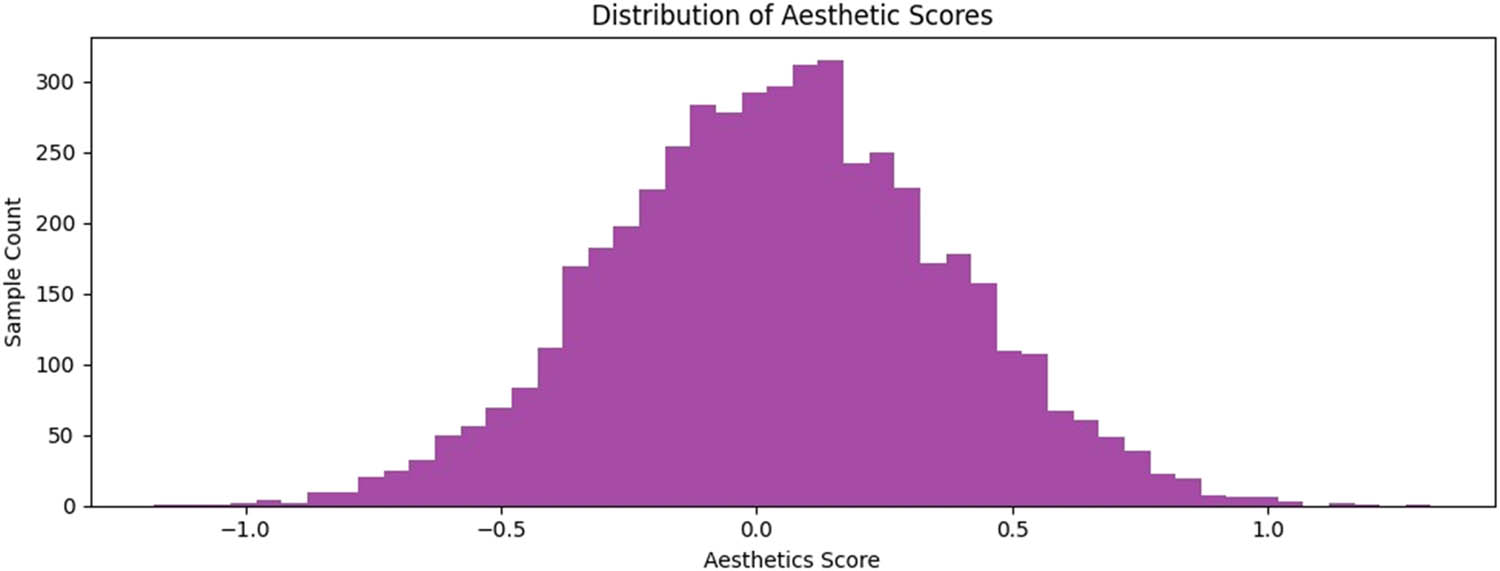
Distribution of aesthetic scores.
4.2 Comparison of dataset
The UGS Model Data (Dataset 1) and Garden Space Planning Data (Dataset 2) provide high-resolution (2,000 × 2,000 px) JPEG images and detailed metadata for urban garden and landscape layouts, enabling AI-driven modeling, 3D simulation, and VR-based urban planning. Both datasets contribute significantly to sustainable and smart green space design. Sourced from the UBGG-3m dataset, which classifies urban areas into blue, green, and gray spaces, they support environmental sustainability and urban ecosystem analysis. Figure 5 shows that the Dataset-1 achieved 98.2% accuracy; Dataset-2 reached 98.5%, while the proposed research model outperformed both with 98.8% accuracy.
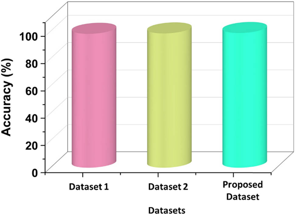
Comparison of accuracy dataset.
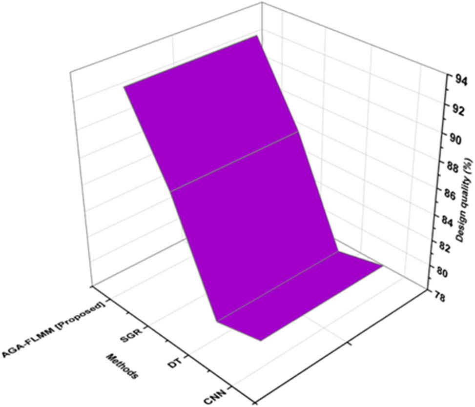
4.3 Design quality
The VR platform should include a wide variety of design components to provide a complete and adaptable garden art design experience. Various kinds of vegetation, flowers, trees, hardscape components, sculptures, and water features are included in this. Designers will have freedom and alternatives to modify the diverse components. Figure 6 depicts the design quality of the proposed and existing methods. Realistic, interactive, user-friendly, and performance-optimized VR design is essential for creating 3D-based garden art. Table 2 depicts the outcomes of the design quality. Designers can develop a potent and compelling virtual environment that encourages creativity and aids in the realization of remarkable garden art ideas by giving these elements the highest priority. Compared with the existing one, the design quality for the proposed model is high (92.89%).
Design quality of the proposed and existing method.
Outcome of the design quality
| Methods | Design quality (%) |
|---|---|
| CNN | 80.12 |
| DT | 79.31 |
| SGR | 87.13 |
| AGA-FLMM [proposed] | 92.89 |
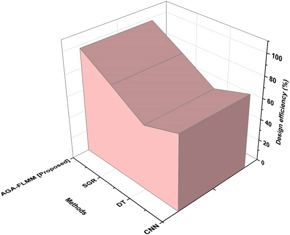
4.4 Design efficiency
To keep the garden art design focused, and on the course, it is crucial to have well-stated design goals and objectives. The design process is guided, and superfluous iterations are avoided by defining the goal and intended aesthetic effect of the artwork. Efficiency depends on selecting the right materials that complement the design intent and the surrounding area. Garden art projects that include sustainable design concepts are more effective and beneficial for the environment. Design effectiveness of the proposed and current methodologies is shown in Figure 7. Design efficiency data are shown in Table 3. Long-term maintenance expenses and resource consumption can be decreased by implementing sustainable techniques, such as adopting native plants, water-efficient irrigation systems, and energy-efficient lighting. The proposed method achieves high efficiency than the existing methods. The proposed method achieves the greatest effective design (97.23%).
Design efficiency of the proposed and existing methods.
Result of the design efficiency
| Methods | Design efficiency (%) |
|---|---|
| CNN | 70.5 |
| DT | 60.12 |
| SGR | 79.2 |
| AGA-FLMM [proposed] | 97.23 |
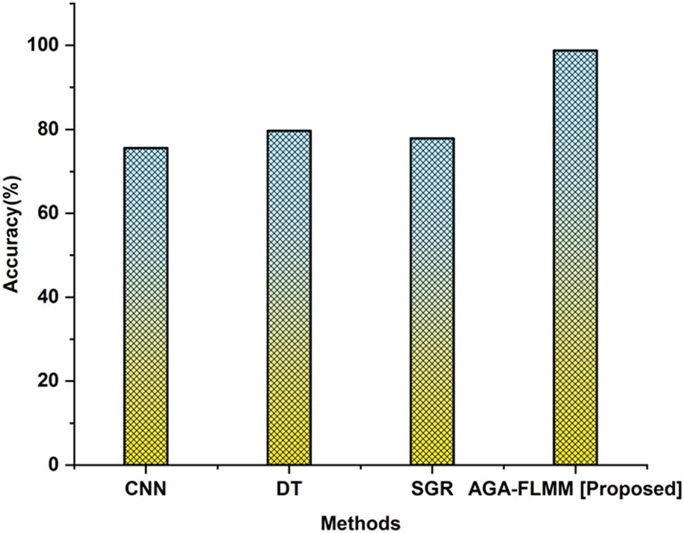
4.5 Accuracy
The competence and knowledge of the craftsmen or artisans engaged in its creation have a significant impact on how accurately the garden art design is executed. It is crucial to engage with seasoned experts who can operate precisely and pay attention to detail. The correctness of the design can be impacted by site-specific elements, including geography, soil characteristics, and climate. For the design to be implemented successfully, the site circumstances must be taken into consideration. Figure 8 illustrates the precision of the suggested and current approaches. Results from accuracy research are shown in Table 4.
Accuracy of the proposed and existing methods.
Outcomes of the accuracy
| Methods | Accuracy (%) |
|---|---|
| CNN | 75.6 |
| DT | 79.71 |
| SGR | 77.89 |
| AGA-FLMM [proposed] | 98.8 |
4.6 Prediction
The amount of upkeep given to the garden will have an effect on how it develops as a whole. Regular weeding, fertilizer, and trimming can result in a well-kept and lively landscape, while neglect can provide a less appealing look. The landscape of the garden can be influenced by environmental variables, including rainfall, temperature, and nearby fauna. For instance, heavy rain or drought can harm a plant’s health and development. Figure 9 shows the agreement between the proposed and current approaches for prediction. Table 5 illustrates the outcome of the garden landscape forecast.
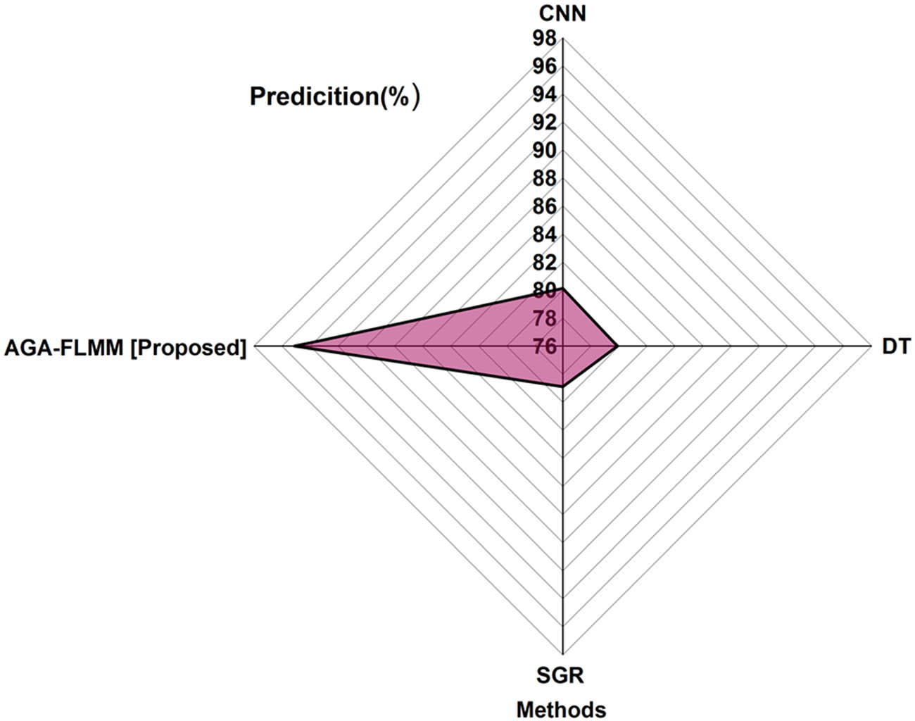
Prediction of the proposed and existing methods.
Result of the garden landscape prediction
| Methods | Prediction (%) |
|---|---|
| CNN | 80.12 |
| DT | 79.9 |
| SGR | 78.9 |
| AGA-FLMM [proposed] | 95.12 |
4.7 Fitness rate
The degree to which a garden art design satisfies the demands, goals, and limits specified by the customer or other project stakeholders is referred to as the design’s fitness rate. It serves as a gauge of how well and efficiently the garden art design satisfies both the expectations of the target audience and the purpose for which it was created. The aesthetic appeal and aesthetic features of a garden art design also influence how suitable it is. In keeping with the overall garden idea, the design should blend in with the surrounding terrain. Safety should be considered in the design of any garden sculpture. It needs to be safe for both people and the environment, managed, and upgradable over time. The relative fitness of the new and old approaches is shown in Figure 10. The results of the fitness rate are shown in Table 6. It shows that the proposed method reaches the highest fitness rate (95.71%) among the existing ones.
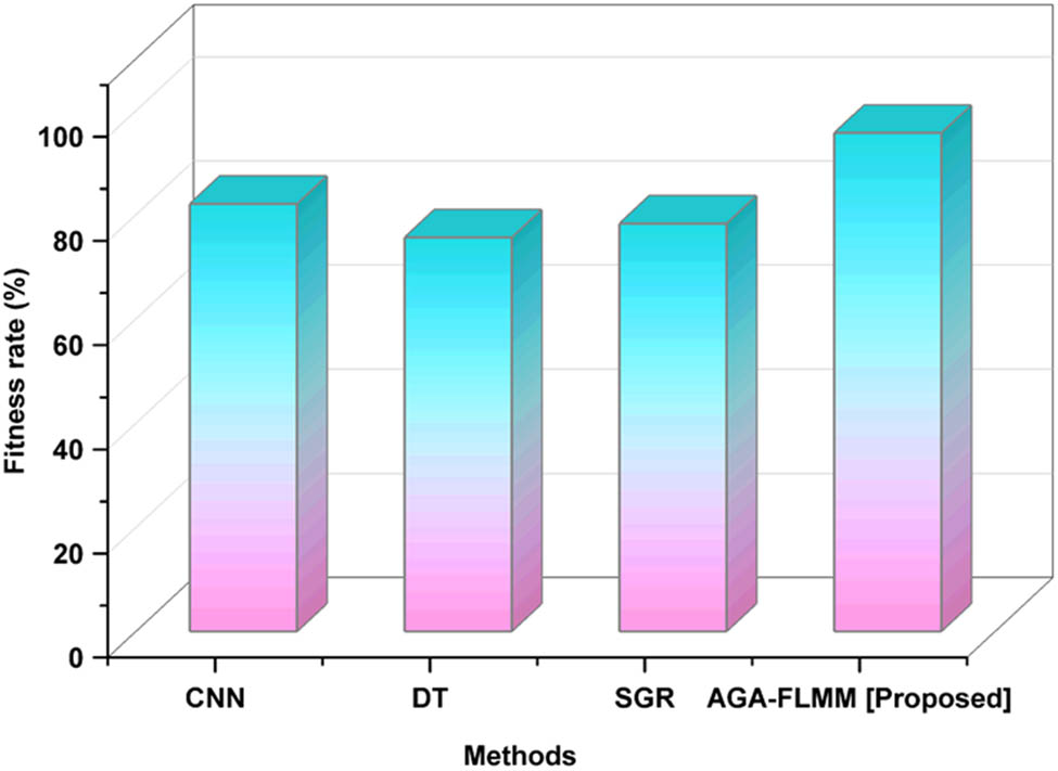
Fitness rate of the proposed and existing methods.
Outcomes of the fitness rate
| Methods | Fitness rate (%) |
|---|---|
| CNN | 82.1 |
| DT | 75.65 |
| SGR | 78.32 |
| AGA-FLMM [proposed] | 95.71 |
4.8 Sensitivity
Designing garden art requires sensitivity to the natural world. A design can be ecologically conscious by using eco-friendly procedures, using sustainable materials, and including native flora. The natural rhythms of the site, such as seasonal changes, light patterns, and animal habits, ought to be respected while designing garden art. Instead of obstructing these organic features, the design should acknowledge and embrace them. Figure 11 depicts the sensitive results. Table 7 shows the sensitivity analysis. When compared to the existing methods, the proposed method has a greater sensitivity (97.91).
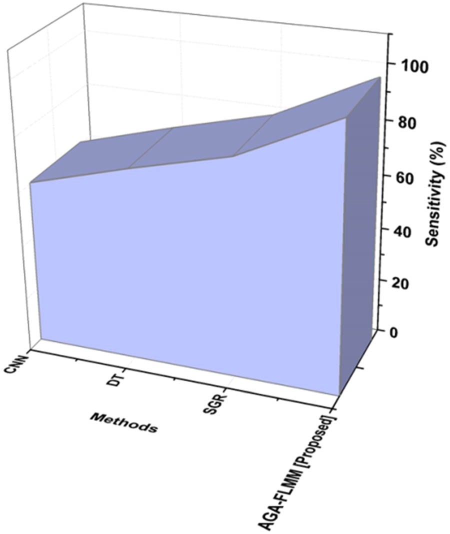
Sensitivity of the existing and proposed methods.
Result of the sensitivity
| Methods | Sensitivity (%) |
|---|---|
| CNN | 60.51 |
| DT | 70.83 |
| SGR | 80.15 |
| AGA-FLMM [proposed] | 97.91 |
5 Discussion
The VR experience described in the research is highly immersive, supporting real-time interaction where users can navigate the 3D garden space; adjust elements such as sculpture placement and plant types; and experience dynamic environmental changes such as weather and lighting. It allows for user-driven modifications, offering a responsive and realistic simulation that enhances design visualization and decision-making. The system is compatible with a range of VR platforms and devices that support immersive, interactive experiences. These include both PC-connected and standalone headsets, as well as mobile-based VR solutions. The system can also integrate with AR and mixed-reality devices, allowing for a flexible and adaptable user experience. These platforms provide varying levels of accessibility, from high-end setups to more mobile-friendly options, ensuring that users can engage with the urban garden design in diverse ways. The system is scalable and adaptable for large public parks, although it was initially optimized for small-to-medium urban gardens. Its modular 3D modeling, fuzzy logic adaptability, and AGA enable efficient handling of complex landscapes, resource management, and user interaction, making it suitable for broader UGS with appropriate computational support. The use of DT, CNN, and SGR presents several drawbacks. DTs can be prone to overfitting, especially with complex datasets, leading to reduced generalizability. CNNs, while powerful for image data, require large datasets and high computational resources, making them less efficient for smaller or structured datasets. SGR, being a geographically-aware model, may suffer from complexity in spatial data interpretation and can be limited by data sparsity or regional inconsistencies. Together, these methods may not be universally optimal across diverse data types or application contexts. The AGA-FLMM can effectively address the drawbacks of DT, CNN, and SGR by combining adaptive optimization with human-like reasoning. The genetic algorithm component optimizes feature selection and rule parameters to avoid overfitting and improve generalization, unlike DTs. The fuzzy logic system handles uncertainty and imprecision in data, making it suitable for smaller or noisy datasets where CNNs may struggle. Additionally, AGA-FLMM does not rely on geographic constraints like SGR, offering more flexible and scalable modeling across various data environments. This research combines VR with a fuzzy mathematical model to enhance urban garden design, focusing on space optimization, resource management, and community engagement. The proposed model encourages sustainable practices by using fuzzy logic to simulate plant suitability based on environmental factors such as sunlight and shade, allowing for adaptive and diverse vegetation choices. It incorporates smart irrigation planning through resource-efficient algorithms and emphasizes energy-saving design elements such as optimal lighting and eco-friendly materials, promoting long-term environmental balance in urban garden layouts. By using the AGA-FLMM, the research provides innovative solutions to urban garden challenges, improving design productivity and aesthetic outcomes. The findings highlight VR’s role in fostering a stronger connection between people and green spaces, offering valuable insights for the future of urban and environmental design. This research presents a smart irrigation system designed for urban gardens within a Smart City framework.
6 Conclusion
The research built a 3D and VR model of urban garden art design, carried out 3D visualization of urban garden modeling, accomplished landscape of a virtual environment shown in 3D, covered the integration and fuzzy mathematical model of garden landscape design schemes, looked at the interactive landscape planning and design schemes using 3D modeling, carried out research, and then analyzed the findings. The proposed method ADA-FLMM achieves more design quality (92.89%), efficiency (97.23%), accuracy (98.8%), and prediction (95.12%). Additionally, two benchmark datasets were employed for comparison, and suggested technique attained an accuracy of 98.8%. To summarize, VR technology uses intelligent drawing to provide design realistic information processing effects, which dramatically increases design efficiency and encourages the effective development of design quality. Professionals can swiftly and intuitively evaluate test findings using 3D virtual technology since it can send a lot of information via images in a short period of time. Integrating VR with dynamic environmental simulations can show how the urban garden will alter as the seasons, weather, and illumination change. The usage of natural light and sustainable design principles can be improved with the help of this feature.
-
Funding information: The authors state no funding involved.
-
Author contributions: All authors have accepted responsibility for the entire content of this manuscript and approved its submission.
-
Conflict of interest: The authors state no conflict of interest.
-
Data availability statement: All data generated or analyzed during this study are included in this published article.
References
[1] A. Naceri, D. Mazzanti, J. Bimbo, Y. T. Tefera, D. Prattichizzo, D. G. Caldwell, et al., “The vicarios virtual reality interface for remote robotic teleoperation: teleporting for intuitive tele-manipulation,” J. Intell. Rob. Syst., vol. 101, pp. 1–16, 2021. 10.1007/s10846-021-01311-7.Suche in Google Scholar
[2] T. Xu, “Performance of VR technology in environmental art design based on multisensor information fusion under computer vision,” Mob. Inf. Syst., vol. 2022, pp. 1–10, 2022. 10.1155/2022/3494535.Suche in Google Scholar
[3] H. Zhang and Y. Deng, “Artificial intelligence based garden landscape design system and 3D visualization technology,” Comput. Des. Appl., vol. 21, pp. 63–76, 2024. 10.14733/cadaps.2024.S3.63-76.Suche in Google Scholar
[4] H. Wang, “Design of commercial building complex based on 3D landscape interaction,” Sci. Program., vol. 2022, pp. 1–8, 2022. 10.1155/2022/7664803.Suche in Google Scholar
[5] P. Xu and C. Wei, “Modularized information fusion design of urban garden landscape in big data background,” Math. Probl. Eng., vol. 2022, , pp. 1–10, 2022. 10.1155/2022/5377872.Suche in Google Scholar
[6] F. Xu and F. Xu, “Building material and spiritual civilization in Sicheng,” Women migrant workers in china’s economic reform, London: Palgrave Macmillan, 2000, pp. 102–128. 10.1057/9780333978092_4.Suche in Google Scholar
[7] Y. Hu and C. Zhang, “Cultural expression of 3D modeling in virtual reality landscape design and mutual aesthetics,” Comput. Des. Appl., vol. 22, pp. 87–100, 2025. 10.14733/cadaps.2025.S2.87-100.Suche in Google Scholar
[8] X. Lin, J. Song, M. An, and Z. Li, “The application of computer augmented reality technology to landscape design,” Procedia Comput. Sci., vol. 243, pp. 187–196, 2024. 10.1016/j.procs.2024.09.025.Suche in Google Scholar
[9] C. Luo, Y. Ju, E. D. S. Gonzalez, P. Dong, and A. Wang, “The waste-to-energy incineration plant site selection based on hesitant fuzzy linguistic Best-Worst method ANP and double parameters TOPSIS approach: A case study in China,” Energy, vol. 211, p. 118564, 2020. 10.1016/j.energy.2020.118564.Suche in Google Scholar
[10] L. Pei, “Green urban garden landscape design and user experience based on virtual reality technology and embedded network,” Environ. Technol. Innov., vol. 24, p. 101738, 2021. 10.1016/j.eti.2021.101738.Suche in Google Scholar
[11] J. Luo, “Online design of green urban garden landscape based on machine learning and computer simulation technology,” Environ. Technol. Innov., vol. 24, p. 101819, 2021. 10.1016/j.eti.2021.101819.Suche in Google Scholar
[12] N. LeeL, M. J. Kim, and W. J. Hwang, “Potential of augmented reality and virtual reality technologies to promote wellbeing in older adults,” Appl. Sci., vol. 9, no. 17, p. 3556, 2019. 10.3390/app9173556.Suche in Google Scholar
[13] A. Aldegheishem, N. Alrajeh, L. García, and LloretJ, “SWAP: smart WAter protocol for the irrigation of urban gardens in smart cities,” IEEE Access, vol. 10, pp. 39239–39247, 2022. 10.1109/ACCESS.2022.3165579.Suche in Google Scholar
[14] P. Shan and W. Sun, “Research on landscape design system based on 3D virtual reality and image processing technology,” Ecol. Inform., vol. 63, p. 101287, 2021. 10.1016/j.ecoinf.2021.101287.Suche in Google Scholar
[15] Z. Fan, N. Zhang, D. Wang, G. Wu, L. Angulo-Cabanillas, and K. Kaur, “Simulation of pear tree growth geometry based on CAD 3D modeling and visualization technology,” Comput. Des. Appl., vol. 20, no. S3, pp. 56–71, 2023. 10.14733/cadaps.2023.S3.56-71.Suche in Google Scholar
[16] B. Zhao, “Urban ecological landscape visualization system based on sign detection algorithm,” Optik, vol. 22, p. 170482, 2022. 10.1016/j.ijleo.2022.170482.Suche in Google Scholar
[17] M. Leyva-Vallina, N. Strisciuglio, and N. Petkov, “Place recognition in gardens by learning visual representations: data set and benchmark analysis,” In Computer Analysis of Images and Patterns: 18th International Conference, CAIP 2019, Salerno, Italy, September 3–5, 2019, Proceedings, Part I 18, Springer International Publishing, 2019, pp. 324–335. 10.1007/978-3-030-29888-3_26.Suche in Google Scholar
[18] C. Shen and C. Yu, “The virtual-real measurement of Chinese garden impression: A quantitative analysis of cognitive experience of Jiangnan gardens with virtual reality experiments,” Front. Archit. Res., vol. 13, no. 4, pp. 895–911, 2024. 10.1016/j.foar.2024.02.007.Suche in Google Scholar
[19] A. E. Permanasari, S. Fauziati, B. M. A. F. Darmawan, I. Langit, M. L. Hakim, I. Hidayah, et al., “Development of mobile butterfly application-based augmented reality as an alternative learning medium during post COVID-19,” In 2022 2nd International Conference on Electronic and Electrical Engineering and Intelligent System (ICE3IS), IEEE, 2022, pp. 125–129. 10.1109/ICE3IS56585.2022.10010151.Suche in Google Scholar
[20] K. G. Kim, C. Oertel, M. Dobricki, J. K. Olsen, A. E. Coppi, A. Cattaneo, et al., “Using immersive virtual reality to support designing skills in vocational education,” Br. J. Educ. Technol., vol. 51, no. 6, pp. 2199–2213, 2020. 10.1111/bjet.13026.Suche in Google Scholar
[21] M. Li, “Application of virtual reality and artificial intelligence technology in landscape planning,” In 2024 2nd International Conference on Mechatronics, IoT and Industrial Informatics (ICMIII), IEEE, 2024, pp. 739–743. 10.1109/ICMIII62623.2024.00144.Suche in Google Scholar
[22] K. Li, “Importance of water ecological environment protection in urban landscape design,” Mob. Inf. Syst., vol. 2022, pp. 1–19, 2022. 10.1155/2022/3767051.Suche in Google Scholar
[23] P. Gong and J. Li, “Application of computer 3D modeling technology in modern garden ecological landscape simulation design,” Secur. Commun. Netw., vol. 2022, pp. 1–10, 2022. 10.1155/2022/7646452.Suche in Google Scholar
[24] Y. Zhu and S. Xie, “Simulation methods realized by virtual reality modeling language for 3D animation considering fuzzy model recognition,” PeerJ Comput. Sci., vol. 10, p. e2354, 2024. 10.7717/peerj-cs.2354.Suche in Google Scholar PubMed PubMed Central
[25] Y. Xie, Y. Hong, and Y. Fang, “Virtual reality primary school mathematics teaching system based on GIS data fusion,” Wirel. Commun. Mob. Comput., vol. 2022, no. 1, p. 7766617, 2022. 10.1155/2022/7766617.Suche in Google Scholar
[26] H. Zhou and Z. Dai, “Green urban garden landscape simulation platform based on high-resolution image recognition technology and GIS.” Microprocess. Microsyst., vol. 82, p. 103893, 2021. 10.1016/j.micpro.2021.103893.Suche in Google Scholar
© 2025 the author(s), published by De Gruyter
This work is licensed under the Creative Commons Attribution 4.0 International License.
Artikel in diesem Heft
- Research Articles
- Air fare sentiment via Backtranslation-CNN-BiLSTM and BERTopic
- Visual analysis of urban design and planning based on virtual reality technology
- Creative design of digital media art based on computer visual aids
- Deep learning-based novel aluminum furniture design style recognition and key technology research
- Research on pattern recognition of tourism consumer behavior based on fuzzy clustering analysis
- Driving business growth through digital transformation: Harnessing human–robot interaction in evolving supply chain management
- Applications of virtual reality technology on a 3D model based on a fuzzy mathematical model in an urban garden art and design setting
- Approximate logic dendritic neuron model classification based on improved DE algorithm
- Special Issue: Human Behavior and User Interfaces
- Study on the influence of biomechanical factors on emotional resonance of participants in red cultural experience activities
- Special Issue: State of the Art Human Action Recognition Systems
- Research on dance action recognition and health promotion technology based on embedded systems