Geohazards (floods and landslides) in the Ndop plain, Cameroon volcanic line
-
Pierre Wotchoko
 ,
Zénon Itiga
,
Zénon Itiga

Abstract
The Ndop Plain, located along the Cameroon Volcanic Line (CVL), is a volcano-tectonic plain, formed by a series of tectonic movements, volcanic eruptions and sedimentation phases. Floods (annually) and landslides (occasionally) occur with devastating environmental effects. However, this plain attracts a lot of inhabitants owing to its fertile alluvial soils. With demographic explosion in the plain, the inhabitants (143,000 people) tend to farm and inhabit new zones which are prone to these geohazards. In this paper, we use field observations, laboratory analyses, satellite imagery and complementary methods using appropriate software to establish hazard (flood and landslide) maps of the Ndop Plain. Natural factors as well as anthropogenic factors are considered.
The hazard maps revealed that 25% of the area is exposed to flood hazard (13% exposed to high flood hazard, 12% to moderate) and 5% of the area is exposed to landslide hazard (2% exposed to high landslide hazard, 3% to moderate). Some mitigation measures for floods (building of artificial levees, raising foundations of buildings and the meticulous regulation of the flood guards at Bamendjing Dam) and landslides (slope terracing, planting of trees, and building retaining walls) are proposed.
1 Introduction
Cameroon is exposed to geohazards (flood, landslide, volcanic eruption; [1]). The International Disaster Database (http://www.emdat.be/www.emdat.be/ see “Database / Country Profile”) points out four catastrophic recent (2007-2012) floods that affected between 10 000 and more than 30 000 inhabitants.
The Ndop Plain (35 × 20km) is situated at a mean altitude of 1150 m along the Cameroon Volcanic Line (CVL). It is surrounded by a series of escarpments which climb up to 2151 m, corresponding to the peripheries of the Mounts Oku and Bamenda, the Mbam and Nkogam Massifs (Fig. 1). The CVL is interpreted as a mega shear zone that seems to be structurally subdivided into an important network of faults associated with a system of alternating horsts and grabens [2–7]. The morphological formations of numerous plains all along the CVL have been discussed by [8, 9] and [10].

A: Location of the CVL (Cameroon Volcanic Line in Africa), B: Location of the Ndop Plain in CVL, C: Relief map showing the geological setting of the Ndop Plain (elevation in m), source (STRM data).
Floods are the major hazard in the Ndop Plain due to its flat nature between a combination of both high and low rise morphologies. Notwithstanding, the Ndop Plain is well inhabited due to the presence of fertile alluvial soils resulting from erosion, transport and deposition of materials from the surrounding hills by streams and rivers. More generally, different geohazards have occurred in the Western Cameroon Highlands (WCH), such as landslides, rock falls and floods [11–16].
In this paper, we shall discuss the topographical and morphological aspects of the Ndop Plain, using Digital Elevation Model (DEM), laboratory analyses, field observations, satellite imagery and computer modeling. The geohazards associated to this plain will also be assessed in terms of typology, and mapped using the Geographic Information System (GIS) approach (see [17]). The findings in this research work will assist to mitigate the effects of geohazards in the Ndop Plain and other plains in Cameroon.
2 Description of the study area
2.1 Geography
The Ndop Plain belongs to the Western Cameroon Highlands (WCH). This sector of the CVL comprises Mounts Bambouto, Bamenda and Oku. The Ndop Plain is partly surrounded by Mount Bamenda to the W-SW and Mount Oku to the N-NW (Fig. 1). The basement is made up of granites and gneisses.
The Ndop area is characterised by two major relief features: a mountainous sector with steep hills and a flat plain ( Fig. 1). This flat relief opens up to Lake Bamendjing (a dam lake) in the south. The soils are lateritic, andosol or alluvial types. These soils are hydromorphic owing to the presence of clays which tend to hold water especially during floods. The drainage pattern is of two types: radial and dendritic (Fig. 2). The climate is subtropical: Annual rainfall and annual average temperature stand at 1700 to 2000 mm and ≈ 21.3°C respectively [18]. Upper Noun Valley Development Authority (UNVDA) annual average rainfall data (2007-2012) is presented in Fig. 3 and substantiates the high rainfall in July and August (up to 600 mm each month). The vegetation is of the Sudan Savannah type [19] and has been greatly modified by anthropogenic activities such as bush fire, intensive farming and overgrazing.

Detailed hydrographic map of the Ndop Plain area.

Annual average rainfall and temperature data (2007-2012) (UNVDA, Upper Noun Valley Development Authority).
2.2 Geological outlines, tectonic and morphological evolution
The Ndop Plain was formed during a series of metamorphic, tectonic, volcanic, and sedimentation phases, which succeeded one another [20]. Structural tectonic activity started with plutonic and metamorphic phases linked to the Pan African Orogeny during the Cambrian period (540 Ma) when gneisses and granites were emplaced [21–23]. The CVL, that was emplaced later, starting at 52 Ma, consists of a series of volcanoes which are separated by plains or low lying areas corresponding to collapsed grabens such as: Tombel, Mbo, Noun, and Tikar [3, 5–10]. Ndop (this paper) is somewhat different as it is a low lying plain.
2.2.1 Pan African plutonic and metamorphic phases
The Pan African Orogeny resulted from the collision of the Congo Craton and the East-Saharan Metacraton during the Neoproterozoic (Ediacarian, 635 to 540 Ma) with its climax near 600 Ma. During this long period, gneisses formed from the protolith and emplaced. During the Cambrian (540–485 Ma) post-collision phase, late granites emplaced, associated with ignimbritic volcanic formations. Then, an intense erosion phase built a peneplain, and this finished during the Late Ordovician (480 Ma) (see [24] and references therein).
2.2.2 Cenozoic magmatic phases
The Ndop Plain is surrounded by a series of volcanic districts such as Mount Bamenda, Mount Oku, and the Nkogam and Mbam Massifs. The formation of the Ndop Plain can thus be correlated to the episodes of formation of these mountains. This magmatic phase is related to the formation of the Cameroon Volcanic Line which has been active since 52 Ma until Present [25, 26].
The radiometric analyses of Mount Bamenda lavas indicate two episodes of felsic volcanism during the Oligocene and Miocene: a first volcanic phase from 27.4 ± 0.5 Ma to 18.7 ± 0.3 Ma and a second volcanic phase from 13.2 ± 0.3 Ma to 12.74 ± 0.25 Ma. The Mount Bamenda felsic volcanism is the oldest of the whole WCH [27]. A mafic volcanic phase emplaced from the Lower Miocene (17.6 Ma) to 0 Ma and shows that mafic volcanism has existed over a long period of time and is partly coeval to the felsic volcanism (between 17.6 and 12.7 Ma) [28, 29].
During the Quaternary up to the Present, weathering and erosion have been intensive, resulting in the formation of Quaternary alluvial deposits on basement rocks. As these materials were transported by streams and rivers, they were deposited into the plain, forming alluvial deposits. These alluvia are rich in the soil nutrients essential for plant growth. This is the reason why the plain is very fertile, evidenced by the presence of the Upper Noun Valley Development Agency (UNVDA) rice plantation.
3 Cartography
3.1 Methods
Our cartography work involved the use of appropriate software such as Surfer 9, MapInfo 8.5, ArcGIS 10.1, Global Mapper 13 and 3DEM, to realize the various maps required for this study. The base maps used during this phase were topographic maps. The procedure employed was as follows:
Topographic maps (1:50,000) of Nkambe 1b and Foumban 3d from the National Institute of Cartography (NIC) Cameroon were georeferenced, and vectors such as contour lines, rivers, localities and roads were digitized.
The GeoTiff DEM of the Ndop was downloaded from NASA’s Shuttle Radar Topography Mission (SRTM V2), with a resolution of 90 m and introduced and imported into the ArcGIS software.
Surface parameters such as contours, reliefs, slope dippings, and slope orientations were realised using the 3D spatial analyst tool in the ArcGIS 10.1 software.
With the Global Mapper software, the DEM of the Ndop Plain was first introduced. The x, y and z data were exported to the Surfer software for further modelling, using the elevation grid and surfer grid in the American Standard Code for Information Interchange (ASCII) format.
The landslide and flood hazard maps for the Ndop Plain were realised with combining or weighting the various parameters in the ArcGIS software. The model employed in mapping the hazards was a data-driven bivariate hazard mapping model (see [16, 30]). The various parameters (predisposition factors) involved in the realization of the hazard map are rock type, soil type, land cover, slope dipping, slope orientation, nature (size) of river and proximity to river (see [31–34], and references therein).
3.2 Characterization of the hazard parameters
The parameters selected for this study were based on field data and on site analysis (Table 1). The choice of variables that affect landslides is an important step in susceptibility assessment and the prediction of new events [35, 36]. Geohazards are complex natural processes which are difficult to model with a few parameters due to variations in instability over space and time and are conditioned by several factors [35, 37–40].
Percentage influence on floods of each of the input raster parameters.
| Data | Data source | Data type | Derived map | Parameter class |
|---|---|---|---|---|
| Material / or rock | Field survey | Polygon | Geologic map | – Basalt |
| – Trachyte | ||||
| – Rhyolite | ||||
| – Ignimbrite | ||||
| – Granite | ||||
| Soil type | Field survey | Polygon | Soil map | – Andosols |
| – Laterites | ||||
| – Colluvium | ||||
| – Alluvium | ||||
| DEM | 1/50,000 topographic map | Line vector | Slope dipping (in degree) | – 0–5 |
| – 5–10 | ||||
| – 10–20 | ||||
| – 20–35 | ||||
| – > 35 | ||||
| Slope orientation | North (0–22.5) | |||
| (in degree) | Northeast (22.5–67.5) | |||
| East (67.5–125) | ||||
| Southeast (112.5–157.5) | ||||
| South (157.5–202.5) | ||||
| Southwest (202.5–247.5) | ||||
| West (247.5–292.5) | ||||
| Northwest (292.5–337.5) | ||||
| North (337.5–360) | ||||
| Rivers | 1/50,000 hydrographic map Field survey | Multiple ring buffer | Distance from river channel (m) | – 100 m |
| – 200 m | ||||
| – 400 m | ||||
| – 600 m | ||||
| Land cover | Google Earth 2013 | Polygon | Land use map | – Built up area |
| – Subsistence farming area | ||||
| – Plantation area | ||||
| – Unused land | ||||
| – Forest area |
The factors chosen here were operational, non-uniform, non-redundant, measurable, and represented over the entire area [41]. They include: rock type, soil type, land cover, slope dipping, slope orientation, distance from river channel and nature of rivers. Rainfall which is an important parameter related to the occurrence of landslides and floods is not used here because it is uniformly distributed in the Ndop Plain. Thematic maps were prepared for each of these factors following the methods here described.
3.2.1 Slope orientation and slope dipping
Very steep slopes surround the flat Ndop Plain (Fig. 4). As pointed out in many regions worldwide, landslides are linked to slopes [16, 36, 42–47]. Two characteristics are classically considered: slope orientation and slope dipping.

Panoramic view of the Ndop Plain (a) very steep slopes surrounding the flat plain, (b) houses along steep slopes.
These slope parameters were realised with the ArcGIS 10.1 software using the DEM of the area in the 3D spatial analyst tool.
An aspect map (slope orientation) is essential in slope failure analysis because of the varying exposure to sunlight and rainfall. Here, the slope orientations range from 0 to 360°, and are grouped into 10 classes: flat (-1), N (0-22.5), NE (22.5-67.5), E (67.5-112.5), SE (112.5-157.5), S (157.5-202.5), SW (202.5-247.5), W (247.5-292.5), NW (292.5-337.5) and N once more (337.5-360) (Fig. 5a). NW facing slopes receive higher precipitation more frequently than SW facing slopes. This is because rainfall is influenced by the effects of the moist southwest monsoon winds originating from the Atlantic Ocean, and the Harmattan trade winds originating from the Sahara Desert in the North [48].

Raster maps of parameters used in hazards mapping in the Ndop Plain. (a) slope orientation (aspect).
The slope dipping was evaluated in degree and grouped into six classes: 0–5°, 5–10°, 10–15°, 15–20°, 20–35°, and > 35° (up to almost vertical) (Fig. 5b). Generally the steeper a slope the higher the hazard of a landslide; however when it becomes too steep, this hazard drops since soil cannot accumulate on very steep slopes [30]) Two zones of the studied area (one in western part and one in north-eastern part) are exposed (Fig. 5b).
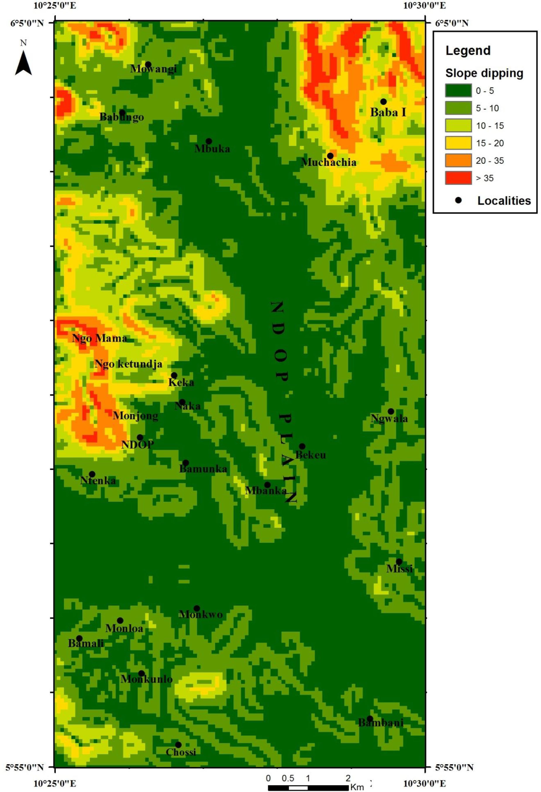
Raster maps of parameters used in hazards mapping in the Ndop Plain. (b) slope dipping.
3.2.2 3-D representation
Precise knowledge of the relief of an area is vital when carrying out landslide studies.
The role of relief in slope instability has been disputed with some authors [49–52] arguing that altitude is a good indicator conditioning slope movements, while others [53] do not see any changes in slope movements between low altitudes and the high altitudes. The three dimensional representation of the relief of the area was done using the DEM, from which vertices of points with spatial references were generated with the Global Mapper 13 software. These vertices were then exported to the Surfer 9 software to generate a 3D representation of the area (Fig. 5c). It is confirmed that the northern part of the studied area is very uneven and hilly compared to the central and southern parts of the area, corresponding to the plain.

Raster maps of parameters used in hazards mapping in the Ndop Plain. (c) 3D representation map, elevation in m.
3.2.3 Land cover
Land use practice may considerably affect the occurrence of landslides in an area [38, 54]. The land cover map was obtained from a SPOT image, map data © 2013, extracted from Google Earth. This image was imported into ArcGis 10.1; the different land uses were manually digitized based on the textures of objects and then calibrated. This was later converted to a raster map and a hazard index was attributed to each class. Five main land use patterns were considered, namely: built up area (25%) close to the town of Ndop (30 000 inhabitants) and five villages, forest (10%) scattered in the plain, subsistence farm area (25%), plantation area (20%) and unused land (20%) corresponding more or less to the principal slopes (Fig. 5d).

Raster maps of parameters used in hazards mapping in the Ndop Plain. (d) land cover map.
3.2.4 Soil type
The occurrence of landslides within a particular area depends noticeably on the soil type [55]. The soil type depends on the rock type and its morphology, but different soil types may result from the same parent rock, following differential weathering and drainage. Soils were not mapped in this research; the soil map produced by ISRIC (International Soil Reference and Information Centre) Library (65.0), PO Box 353 6700 A.J. Wageningen, The Netherlands, was digitized and used for our study.
Five soil type patterns were adopted which are: soils formed from recent lava flows (12%), andosol (8%), laterite (5%) close to Babungo, colluvium (35%) and alluvium (40%) (Fig. 5e). Andosols are located on steep slopes and are less stable than colluvium and alluvium which are formed on gentle to flat slopes. Hence andosols have a higher hazard index [20]. These different soil types were manually digitized in the ArcGis 10.1 software and converted into a raster map and index values attributed to it.
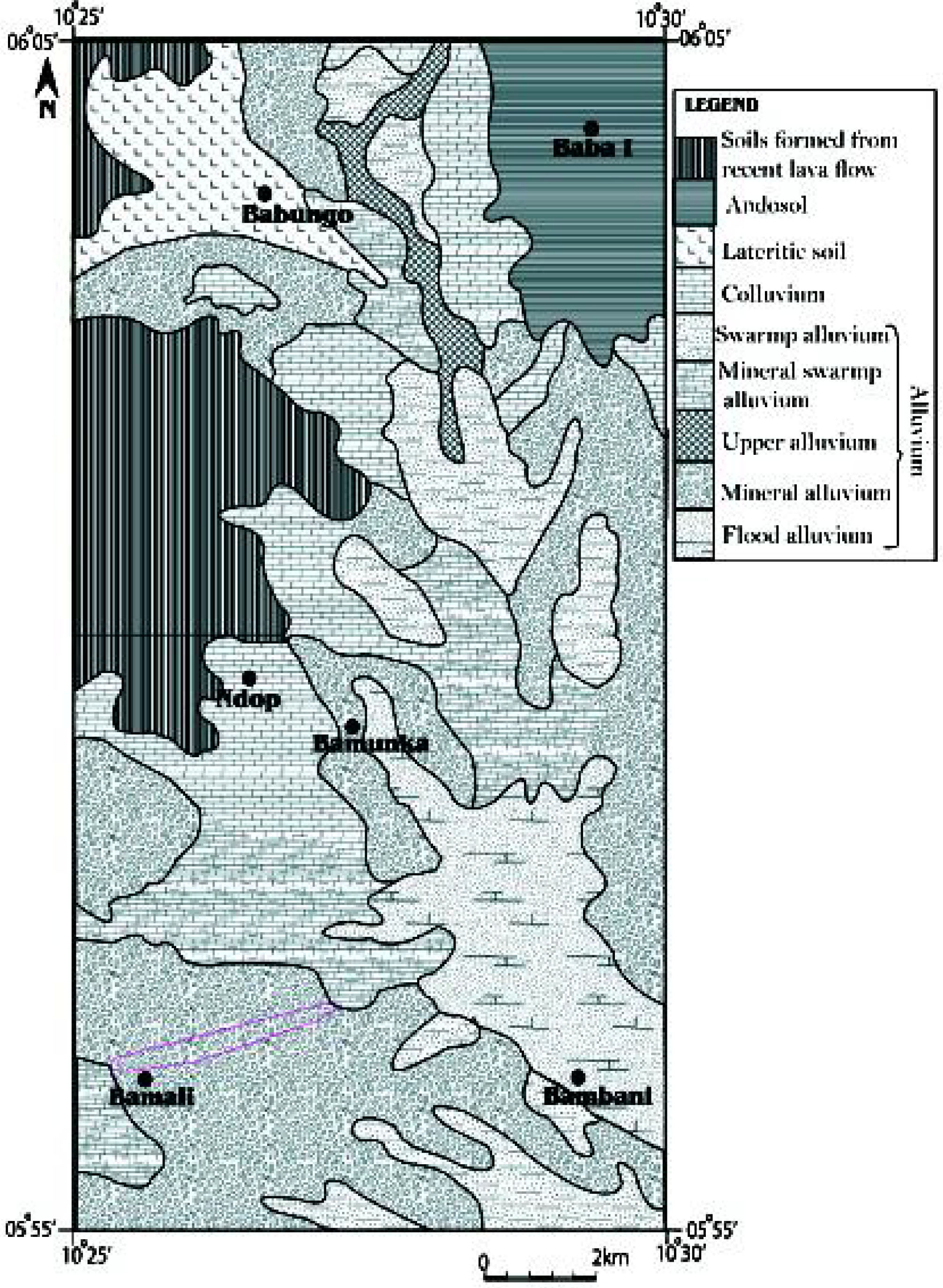
Raster maps of parameters used in hazards mapping in the Ndop Plain. (e) soil map.
3.2.5 Rock type (material)
The studied area is covered by the following rock types: plutonic rock (20% granite and gneiss), volcanic rock (15% basalt, 4% trachyte, 5% rhyolite and 5% ignimbrite) (Fig. 5f). The rest of the area is covered by alluvial materials. Two representative samples of each rock were collected in the study area for the preparation of thin sections.
![Figure 5f Raster maps of parameters used in hazards mapping in the Ndop Plain. (f) geologic map of Ndop [16].](/document/doi/10.1515/geo-2016-0030/asset/graphic/j_geo-2016-0030_fig_005f.jpg)
Raster maps of parameters used in hazards mapping in the Ndop Plain. (f) geologic map of Ndop [16].
Granites show a porphyritic granular texture with angular phenocrysts interlocked. It is made up of quartz, orthoclase, biotite, microcline, and opaque minerals (Fig. 6a). Basalts present a microlitic texture; they contain minerals such as olivine, pyroxene, plagioclase and opaque Fe-Ti oxides which occur as phenocrysts. These mineral phases also constitute the groundmass (Fig. 6b). Trachytes present a microlitic porpyhritic texture with phenocrysts of sanidine and oxides which are automorphic and well developed; chlorite is also present in these rocks (Fig. 6c). The crystalline phases are embedded in a groundmass made up of microlites of sanidine, biotite and oxides. The groundmass displays a preferred orientation of alkali feldspars. This rock evidences re-crystallization of calcite indicating that weathering is taking place. Rhyolites show a microlitic porpyhritic texture, with minerals such as alkali feldspar, pyroxene, quartz, and oxides in a glassy groundmass (Fig. 6d). The groundmass shows a fluidal structure with preferred orientation of the feldspars and devitrification of the quartz. Ignimbrites have a vitroclastic texture made up of rock fragments, broken pieces of feldspars (sanidine and plagioclase), quartz and fiammes embedded in a glassy groundmass (Fig. 6e). Locally, groundmass is devitrified into small quartz and feldspar crystals.

Photomicrography (under crossed-nicols) of rocks from Ndop area; (a) Granite (b) Basalt (c) Trachyte (d) Rhyolite and (e) Ignimbrite. Amp = amphibole, Bt = biotite, Cl = chlorite, Mi = microcline, Ol = olivine, Or = orthoclase, Ox = Fe-Ti oxide, Px = pyroxene, Qtz = quartz, Sa = sanidine. Glass and spherulite are shown in (d) and fiamme structures are shown in (e) where indicated.
The rock type distribution in an area may affect landslides at different scales. A lithological sketch map was realized from field observation data, thin section analysis (Fig. 6), reading and interpretation of satellite images (i.e. vegetation cover helped in characterizing unexposed outcrops as vegetation cover is scarce when growing on thin layers of soil lying on rock) and DEM (i.e. 3D view helped to locate domes in the area, regardless if they were covered by vegetation or not). The difficulty to observe the contact and extension of different rock units reduced the accuracy of this map.
3.2.6 Nature and proximity to river
The nature of the rivers was determined from the dimension of the river channels. This was obtained by digitizing the 1:50,000 topographic maps of Nkambe 1b and Foumban 3d using the ArcGIS 10.1 software and also from field work. Rivers were grouped into five classes, from the largest to the smallest: major river, main river, river, stream and temporal stream. The dimensions of the rivers increase as the rivers flow into lowlands and coalesce together. Generally, the wider and shallower a river channel, the higher the degree of flood hazard is. Moreover, some streams may cause severe floods when they receive an abnormal influx of water. In case of a flood, the areas close to a river channel are highly affected compared to distant areas. A ring buffer was realised at a distance of 600 m from the river at intervals of 100 m, 200 m, 400 m and 600 m and grouped into four classes (Fig. 5g). Proximity to rivers was implemented by applying the Euclidean distance function in ArcGIS using the multiple buffer tool.
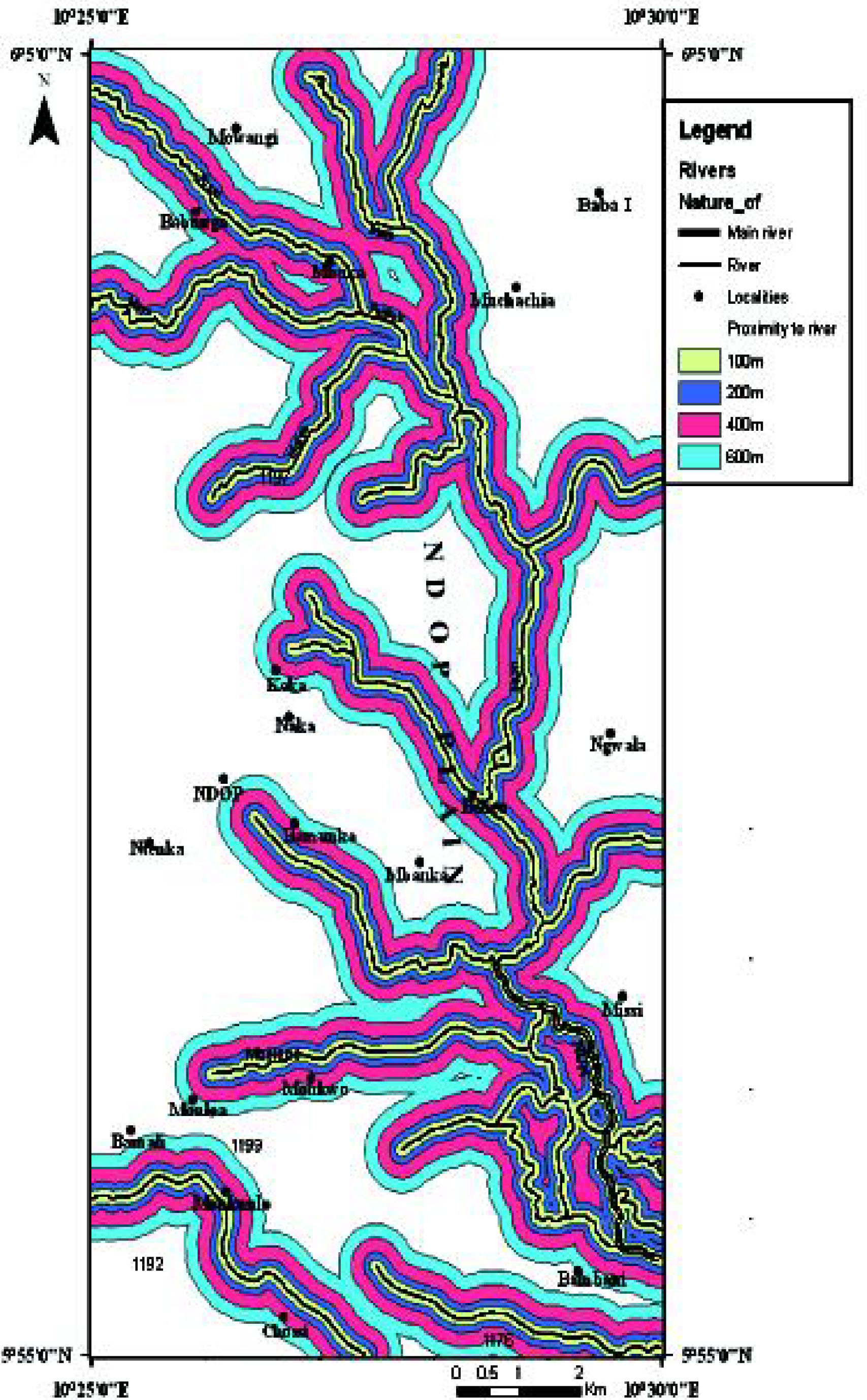
Raster maps of parameters used in hazards mapping in the Ndop Plain. (g) proximity to river map.
3.2.7 Combining hazard parameters
Many different types of landslide hazard zonation techniques have been developed over the last decades, and the difficulty lies in the weighting the factors [32, 56–60]. In this paper, the parameters were weighted as follows: the model builder was used in the ArcGIS 10.1 software and all the environmental settings were checked such as processing extent, raster analysis and cell size. The parameters were then introduced into the model builder and reclassified to realize floating points, continuous datasets, categorize datasets into ranges, and assign each range of values a discrete integer value. Each parameter was classified based on its influence on landslides and floods. Dipping slopes, for example, were reclassified by assigning new input field values to them. Consequently, steeper slopes were assigned higher values and less steep slopes lower values. This was done for the other parameters used in the model. Using the connection tools, the parameters were connected with their input data, their corresponding tools and their resultant outputs raster. The model was then run to ensure functionality.
Using the weighted overlay tool, the values of each dataset were then weighted [44, 60], and all input parameters were assigned each a percentage of influence or hazard index. The higher the percentage of influence, the greater impact a particular input parameter will have on landslides or floods. The percentage of influence for both landslides and floods are presented in Tables 2 and 3. Accordingly, the weighted overlay operation was done as follows; 1, 10, and 1 were typed in the From, To, and By fields in the weighted overlay tool box to avoid having to update the scale values after adding the input datasets. At this level, some field values were restricted to give them a minimum value in the evaluation process, as, for example, steep dipping slopes > 35° cannot be exposed to flood hazards while flat areas cannot be exposed to landslides.
Percentage influence on landslides of each of the input raster parameters.
| Raster parameter | Percentage influence or hazard index (%) | Input field | |
|---|---|---|---|
| 1 | Land cover | 15 | Land cover |
| 2 | Reclassed soil type | 15 | Value |
| 3 | Reclassed slope | 50 | Value |
| 4 | Reclassed proximity to rivers | 20 | Value |
Some suggestions to mitigate geohazards on the Ndop Plain.
| Raster parameter | Percentage influence or hazard index (%) | Input field | |
|---|---|---|---|
| 1 | Reclassed slope dipping | 50 | Value |
| 2 | Reclassed soil type | 20 | Value |
| 3 | Reclassed proximity to rivers | 10 | Value |
| 4 | Reclassed slope orientation | 5 | Value |
| 5 | Land cover | 15 | Land cover |
4 Discussions and conclusions
4.1 Causes of the geohazards and mapping
The causes of floods in the area include natural causes (siltation, peculiar geomorphology, the nature of soils, and rainfall) as well as anthropogenic causes (subsistence farming, plantation agriculture, the dam-backing effect of the Bamendjing Dam, and dumping of refuse into rivers). For landslides, natural causes include rainfall, slope steepness, groundwater, gravity, and the erosion of the toe of slopes by rivers, while anthropogenic causes consist of deforestation, excavation, and anarchical construction as pointed out by Che et al. (2010). Among all the mentioned causes, slope steepness is the most important in this area. Note that anthropogenic factors have a minor effect compared to natural factors.
In hazard mapping, the main problem resides in the combination of factors. These factors are not standardized nor regulated by any international norm. In this study, the selected factors are based on physical data obtained from the field. They do not affect flood and landslide hazards to the same degree. It is a combination of these parameters acting together which cause the hazard. The realization of the hazard map (Fig. 7) consists of computational weighting all these parameters. The percentage of influence (hazard index) for each parameter (listed in Table 1) on the flood and landslide event has been recapitulated in Tables 2 and 3. It should be noted that hazard indices vary from one area to another.
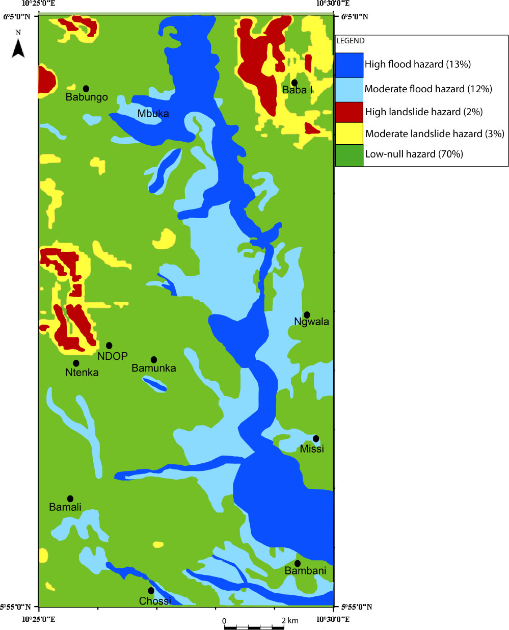
Hazard map of the Ndop Plain. Percentages of the surfaces of exposed areas are listed.
From the results obtained it is observed that flood hazard may affect about 25% of the studied area, along a north-south stripe: 13% are exposed to high flood hazard and 12% to moderate (Fig. 7). Landside hazard impacts about 5% of the area, along the borders: 2% are exposed to high landslide hazard and 3% to moderate. None of the hazard areas overlap. Thus, about 30% of the area is exposed to a natural hazard (Fig. 7).Although floods are destructive, they are also beneficial in the agricultural plain: flooded areas which are swampy are crucial for the growth of Ndop rice.
More generally, geohazards are common in Cameroon especially along the CVL [11, 12, 14], with landslides [13, 30, 61] and floods [16] having devastating effects on man and the environment. Landslides impact areas with slopes of more than 35° (see Fig. 5b and 7, 35–80° according to [62]) while floods are the most widespread hazard in the plain and affects all localities when it does occur [65].
This is true in all rainy tropical volcanic (active or extinct) regions with contrasting relief, i.e. on oceanic islands [i.e. Tahiti 31]; [Cape Verde 63] as well as on continents (Uganda, [64]), with various magnitudes.
Ref. [30] point out the increase of human risks in CVL as evidenced by the loss of about 30 lives within the last 20 years because of numerous landslides in the Limbe area on the foot slope of Mount Cameroon. Twenty-four people died during the 2001 Limbe landslide (2800 people homeless) and five others during the 2003 Bambouto-Magha landslide [13, 62].
Ref.[16] used similar parameters, such as slope, rock type and soil type, to map the landslide, rock fall and flood hazards in the environs of Bamenda that have severe environmental and socioeconomic impacts on the population. In the same way, [14] described natural hazards in the Mount Bambouto caldera, where landslides are most frequent.
A retrospective analysis of data from the last three decades clearly indicates an upward trend in the number of landslides in Cameroon [13]. A proper hazard monitoring and assessment committee needs to set up to manage these hazards better as attention is only paid in cases where there are casualties or severe destruction. A proper understanding of geohazards is vital for the management and understanding of landscape evolution for sustainable development and a better arrangement of the national territory.
4.2 Suggestions for the mitigation and management of geohazards
To render these hazards less severe or less devastating, some mitigation and management measures are proposed to be implemented in the Ndop Plain. Mitigation involves emplacing measures in the geological context, while management involves measures in the way that people can manage themselves and respond to geohazards successfully to ultimately survive. These suggestions are presented in Tables 4 and 5.
Some suggestions to manage geohazards on the Ndop Plain.
| Floods | Landslides |
|---|---|
| – Deepening of the river bed to increase the capacity of the river; | – The flanks of hills should not be excavated without any geotechnical measure emplaced to stabilize the slope; |
| – Cleaning of gutters especially where they meet rivers to ease the flow of water; | – Stabilizing structures should be constructed such as embankments and other retaining walls; |
| – Straightening the river channels; this avoids excessive sedimentation of the river bed; | – Very steep slopes should be terraced when a road is excavated; |
| – Building artificial levees; this prevents water from overflowing its banks; | – Grass or other plants should be planted along steep slopes; |
| – Raise foundations of buildings: if foundations are high, water will find it difficult to enter houses as is the case in some minor floods; | – Groundwater should be drained in sensitive areas; |
| – Constructing larger and higher bridges: refuse has the tendency of blocking | – Very steep slopes can be graded to reduce their gradient. |
| small and low bridges forcing water to flow out of its normal channel; | |
| – Avoid farming around river channels since this activity disrupts the soil | |
| structure and fine particles are easily carried into the river bed; | |
| – Planting new trees and preventing the felling of trees; | |
| – Construction in flat areas should be avoided since these areas are susceptible to floods; | |
| – Meticulous regulation of the flood guards at the Bamendjing Dam so as to avoid water from flooding new areas. |
Some suggestions to manage geohazards on the Ndop Plain.
| Floods | Landslides |
|---|---|
| – Go to high areas that the rise of water cannot attain; | – Immediately evacuate injured or disabled people from the slide area; |
| – Listen for any unusual sounds that might indicate moving debris, such as trees cracking or boulders knocking together; | – Do not loiter around a landslide for there may be a post landslide event; |
| – If trapped in a building climb to the roof of the building; | – Stay alert and awake; many debris-flow fatalities occur when people are sleeping; |
| – Put on life jackets when available before walking in flooded areas; | – Stay out of the path of a landslide; |
| – Progressively remove water as it floods a building either by pumping or by using a bucket. | – When driving on a highway be alert of landslide debris blocking the road. |
Acknowledgement
B. Bonin is thanked for useful remarks. Careful reviews by C. Principe and an anonymous reviewer greatly helped to improve the manuscript.
References
[1] Fogwe Zephania, N., 2010. Mitigating and managing regional geo-environmental hazards within a decentralisation transition in Cameroon. J. Hum. Ecol., 30, 3, 187-195.10.1080/09709274.2010.11906288Search in Google Scholar
[2] Gèze, B., 1943. Géographie physique et géologie du Cameroun occidental. Mém. Muséum Nation. Hist. Natur, Paris, Nlle série, 17, 271 p.Search in Google Scholar
[3] Fitton, J.G., 1987. The Cameroon line, West Africa: A comparison between oceanic and continental alkaline volcanism. In: Fitton, J.G. & Upton, B.G.J. (Eds.) Alkaline igneous rocks. Geol. Soc. London Spec. Publ., 30, 273–291.10.1144/GSL.SP.1987.030.01.13Search in Google Scholar
[4] Moreau, C., Regnoult, J.M., Déruelle, B. & Robineau, B., 1987. A new tectonic model for the Cameroon line, Central Africa. Tectonophysics, 139, 317–334.10.1016/0040-1951(87)90206-XSearch in Google Scholar
[5] Déruelle, B., Moreau, C., Nkoumbou, C., Kambou, R., Lissom, J., Njonfang, E., Ghogomu, R.T. & Nono, A., 1991. The Cameroon Line: A review. In: Kampunzu, A.B., Lubala, R.T. (Eds.) Magmatism in Extensional Structural Settings. Springer, Berlin, pp 274–327.10.1007/978-3-642-73966-8_12Search in Google Scholar
[6] Déruelle, B., Ngounouno, I. & Demaiffe, D., 2007. The ‘Cameroon Hot Line’ (CHL): A unique example of active alkaline intraplate structure in both oceanic and continental lithospheres. C. R. Geoscience, 339, 9, 589–600.10.1016/j.crte.2007.07.007Search in Google Scholar
[7] Fosso, J., Ménard, J.J., Bardintzeff, J.M., Wandji, P., Tchoua, F.M. & Bellon, H., 2005. Les laves du mont Bangou: Une première manifestation volcanique éocène, à affinité transitionnelle, de la Ligne du Cameroun. C. R. Geoscience, 337, 315–325.10.1016/j.crte.2004.10.014Search in Google Scholar
[8] Nkouathio, D.G., Ménard, J.J., Wandji, P. & Bardintzeff, J.M., 2002. The Tombel graben (West Cameroon): A recent monogenetic volcanic field of the Cameroon Line. J. Afr. Earth Sci., 35, 2, 285–300.10.1016/S0899-5362(02)00031-3Search in Google Scholar
[9] Nkouathio, D.G., Kagou Dongmo, A., Bardintzeff, J.M., Wandji, P., Bellon, H. & Pouclet, A., 2008. Evolution of volcanism in graben and horst structures along the Cenozoic Cameroon Line (Africa): Implications for tectonic evolution and mantle source composition. Mineral. Petrol., 94, 3–4, 287–303.10.1007/s00710-008-0018-1Search in Google Scholar
[10] Itiga, Z., Chakam Tagheu, P.J., Wotchoko, P., Wandji, P., Bardintzeff, J.M. & Bellon, H., 2004. La Ligne du Cameroun: Volcanologie et géochronologie de trois régions (mont Manengouba, plaine du Noun et Tchabal Gangdaba). Géochronique, 91, 13–16.Search in Google Scholar
[11] Tchoua, F.M., 1984. Les coulées boueuses de Dschang (Août 1978). Rev. Géogr. Cameroun 2:25–33.Search in Google Scholar
[12] Tchoua, F.M., 1989. Les matériaux des coulées boueuses de Dschang (Août 1978). Rev. Géogr. Cameroun, 8, 1, 58–64.Search in Google Scholar
[13] Zogning, A., Ngouanet, C. & Tiafack, O., 2007. The catastrophic geomorphological processes in humid tropical Africa: A case study of the recent landslide disasters in Cameroon. Sedimentary Geology, 199, 1–2, 13–27.10.1016/j.sedgeo.2006.03.030Search in Google Scholar
[14] Zangmo, T.G., Kagou Dongmo, A., Nkouathio, D.G. & Wandji, P., 2009. Typology of natural hazards and assessment of associated risks in the Mount Bambouto caldera (Cameroon Line, West Cameroon). Acta Geologica Sinica, 83, 5, 1008–1016.10.1111/j.1755-6724.2009.00130.xSearch in Google Scholar
[15] Aboubakar, B., Kagou Dongmo, A., Nkouathio, D.G. & Ngapgue, F., 2013. Instabilités de terrain dans les hautes terres de l’Ouest Cameroun: Caractérisation géologique et géotechnique du glissement de terrain de Kekem. Bull. Institut Scientifique, Rabat, Maroc, section Sci. de la Terre, 35, 39–51.Search in Google Scholar
[16] Guedjeo, C.S., Kagou Dongmo, A., Ngapgue, F., Nkouathio, D.G., Zangmo Tefogoum, G., Gountié Dedzo, M. & Nono, A., 2013. Natural hazards along the Bamenda escarpment and its environs: The case of landslide, rock fall and flood risks (Cameroon volcanic line, North-West Region). Global Adv. Res. J. Geol. Min. Res., 2, 1, 15–26.Search in Google Scholar
[17] Hamadouche, M.A., Mederbal, K., Kouri, L., Regagba, Z., Fekir, Y. & Anteur, D., 2014. GIS-based multicriteria analysis: An approach to select priority areas for preservation in the Ahaggar National Park, Algeria. Arabian J. Geosci., 7, 2, 429–434.10.1007/s12517-012-0817-xSearch in Google Scholar
[18] Ndenecho, E.N., 2009. Cropping systems and post cultivation succession, agro-ecosystem in Ndop Cameroon. J. Human Ecology, 27, 1, 26–34.10.1080/09709274.2009.11906188Search in Google Scholar
[19] Neba, A., 1999. Modern Geography of the Republic of Cameroon. 3rd Edition, Neba Publishers- Bamenda, Cameroon.Search in Google Scholar
[20] Guedjeo, C.S., 2013. Genesis of the Ndop Plain, associated geohazards and environmental impact (North-West Region). HTTC thesis, University of Bamenda, Cameroon, 70 p.Search in Google Scholar
[21] Tagne-Kamga, G., Mercier, E., Rossy, M. & Nsifa, N.E., 1999. Synkinematic emplacement of the Pan-African Ngondo igneous complex (West Cameroon, Central Africa). J. Afr. Earth Sci., 28, 675–691.10.1016/S0899-5362(99)00038-XSearch in Google Scholar
[22] Abdelsalam, M.G., Liégeois, J.P. & Stern, R.J., 2002. The Saharan metacraton. J. Afr. Earth Sci., 34, 119–136.10.1016/S0899-5362(02)00013-1Search in Google Scholar
[23] Njanko, T., Nédélec, A. & Affaton, P., 2006. Synkinematic high-K calc-alkaline plutons associated with the Pan-African Central Cameroon Shear Zone (W Tibati area): Petrology and geodynamic significance. J. Afr. Earth Sci., 44, 494–510.10.1016/j.jafrearsci.2005.11.016Search in Google Scholar
[24] Toteu, S.F., Van Schmus, W.R., Penaye, J. & Michard, A., 2001. New U-Pb and Sm-Nd data from north-central Cameroon and its bearing on the pre-Pan African history of central Africa. Precambrian Res., 108, 1–2, 45–73.10.1016/S0301-9268(00)00149-2Search in Google Scholar
[25] Moundi, A., Wandji, P., Bardintzeff, J.M., Ménard, J.J., Okomo Atouba, L.C., Mouncherou, O.F., Reusser, E., Bellon, H. & Tchoua, F.M., 2007. Les basaltes éocènes à affinité transitionnelle du plateau Bamoun, témoins d’un réservoir mantellique enrichi sous la ligne volcanique du Cameroun. C. R. Geoscience, 339, 396–406.10.1016/j.crte.2007.04.001Search in Google Scholar
[26] Yokoyama, T., Aka, F.T., Kusakabe, M. & Nakamura, E., 2007. Plume-lithosphere interaction beneath Mt. Cameroon volcano, West Africa: Constraints from 238U–230Th–226Ra and Sr–Nd–Pb isotopes systematics. Geochim. Cosmochim. Acta, 71, 1835–1854.10.1016/j.gca.2007.01.010Search in Google Scholar
[27] Kamgang, P., Njongang, E., Nono, A., Gountie Dedzo, M. & Tchoua, F., 2010. Petrogenesis of a silicic magma system; Geochemical evidence from the Bamenda mountains, NW Cameroon, Cameroon Volcanic Line. J. Afr. Earth Sci., 58, 285–304.10.1016/j.jafrearsci.2010.03.008Search in Google Scholar
[28] Kamgang, P., Njonfang, E., Chazot, G. & Tchoua, F., 2008. Geochemistry and geochronology of mafic rocks from the Bamenda mountains (Cameroon): Source composition and crustal contamination along the Cameroon Volcanic Line. C. R. Geoscience, 340, 850-857.10.1016/j.crte.2008.08.008Search in Google Scholar
[29] Kagou Dongmo A., Nkouathio D.G., Pouclet A., Bardintzeff J.M., Wandji P., Nono A. & Guillou H., 2010. The discovery of late Quaternary basalt on Mount Bambouto: Implications for recent widespread volcanic activity in the southern Cameroon Line. J. Afr. Earth Sci., 57, 1–2, 96–108.10.1016/j.jafrearsci.2009.07.015Search in Google Scholar
[30] Che, V.B., Kervyn, M., Ernst, G.G.J., Trefois, P., Ayonghe, S., Jacobs, P., Van Ranst, E. & Suh, C.E., 2011. Systematic documentation of landslide events in Limbe area (Mt Cameroon Volcano, SW Cameroon): geometry, controlling, and triggering factors. Natural Hazards, 59, 47–74.10.1007/s11069-011-9738-3Search in Google Scholar
[31] Guillande, R., Gelugne, P., Bardintzeff, J.M., Brousse, R., Chorowicz, J., Deffontaines, B. & Parrot, J.F., 1993. Cartographie automatique de zones à aléas de mouvements de terrain sur l’ı *le de Tahiti à partir de données digitales. Bull. Soc. Géol. Fr., 164, 4, 577–583.Search in Google Scholar
[32] van Westen, C.J., Rengers, N. & Soeters, R., 2003. Use of geomorphological information in indirect landslide susceptibility assessment. Nat. Hazards, 30, 3, 399–419.10.1023/B:NHAZ.0000007097.42735.9eSearch in Google Scholar
[33] van Westen, C.J., van Asch, T.W.J. & Soeters, R., 2006. Landslide hazards and risk zonation-Why is it still so difficult? Bull. Engineering Geol. Environ., 65, 2, 167–184.10.1007/s10064-005-0023-0Search in Google Scholar
[34] Guzzetti, F., Ardizzone, F., Cardinali, M., Rossi, M. & Valigi, D., 2009. Landslide volumes and landslide mobilization rates in Umbria, central Italy. Earth Planet. Sci. Lett., 279, 3–4, 222–229.10.1016/j.epsl.2009.01.005Search in Google Scholar
[35] Bateira, C. & Soares, L., 1997. Movimentos em massa no norte de Portugal. Factores da sua ocorrência. Territorium, 4, 63–77.10.14195/1647-7723_4_6Search in Google Scholar
[36] Papathanassiou, G., Valkaniotis, S., Ganas, A. & Pavlides, S., 2013. GIS-based statistical analysis of the spatial distribution of earthquake-induced landslides in the island of Lefkada, Ionian Islands, Greece. Landslides, 10, 771–783.10.1007/s10346-012-0357-1Search in Google Scholar
[37] Irigaray, C., Fernandez, T. & Chacón, J., 1996. Inventory and analysis of determining factors by a GIS in the northern edge of the Granada Basin. In: Senneset, K. (Ed.), Landslides – Glissements de Terrain. Balkema, Rotterdam, vol. 3, 1915–1921.Search in Google Scholar
[38] Zêzere, J.L., Ferreira, A.B. & Rodrigues, M.L., 1999. Landslides in the north of Lisbon region (Portugal): Conditioning and triggering factors. Physics Chem. Earth, Part A, 24, 10, 925–934.10.1016/S1464-1895(99)00137-4Search in Google Scholar
[39] Nagarajan, R., Roy, A., Vinod Kumar, R., Mukherjee, A. & Khire, M.V., 2000. Landslide susceptibility mapping based on terrain and climatic factors for tropical monsoon regions. Bull. Eng. Geol. and Env., 58, 275–287.10.1007/s100649900032Search in Google Scholar
[40] Eze, B. & Ndenecho, E., 2004. Geomorphic and anthropogenic factors influencing landslides in the Bamenda Highlands, North West Province, Cameroon. J. Applied Social Sci., 4, 1, 15–26.Search in Google Scholar
[41] Ayalew, L., Yamagishi, H., Marui, H. & Kanno, T., 2005. Landslide in Sado Island Japan: GIS-based susceptibility mapping with comparison of results from two methods and verifications. Engineering Geol., 81, 432–445.10.1016/j.enggeo.2005.08.004Search in Google Scholar
[42] Ayonghe, S.N., Mafany, G.T., Ntasin, E. & Samalang, P., 1999. Seismically activated swarm of landslides, tension cracks, and a rockfall after heavy rainfall in Bafaka, Cameroon. Natural Hazards, 19, 13–27.10.1023/A:1008041205256Search in Google Scholar
[43] Guzzetti, F., 2000. Landslide fatalities and the evaluation of landslide risk in Italy. Engineering Geol., 58, 2, 89–107.10.1016/S0013-7952(00)00047-8Search in Google Scholar
[44] Süzen, M.L. & Doyuran, V., 2004. A comparison of the GIS based landslide susceptibility assessment methods: Multivariate versus bivariate. Environmental Geol., 45, 665–679.10.1007/s00254-003-0917-8Search in Google Scholar
[45] Carrara, A., Crosta, G. & Frattini, P., 2008. Comparing models of debris-flow susceptibility in the alpine environment. Geomorphology, 94, 3, 353–378.10.1016/j.geomorph.2006.10.033Search in Google Scholar
[46] Galli, M., Ardizzone, F., Cardinali, M., Guzzetti, F. & Reichenbach, P., 2008. Comparing landslide inventory maps. Geomorphology, 94, 268-289.10.1016/j.geomorph.2006.09.023Search in Google Scholar
[47] Zêzere, J.L., Henriques, C.S., Garcia, R.A.C., Oliveira, S.C., Piedade, A. & Neves, M., 2009., Effects of landslide inventories uncertainty on landslide susceptibility modelling. In: Mallet, J.-P., Remaitre, A. & Boggard, T. (Eds.), Landslide Processes: From Geomorphologic Mapping to Dynamic Modelling. CERG Editions, Strasbourg, p.81–86.Search in Google Scholar
[48] Afungang, R.N., 2010. Erosion, mass movement and landscape dynamics: A case study of the Mezam highlands. Master’s thesis in landscape dynamics and risk. Department of Geography, University of Yaounde1-Cameroon, 181 p.Search in Google Scholar
[49] Pachauri, A.K. & Pant, M., 1992. Landslide Hazard Mapping Based on Geological Attributes. Engineering Geology, 32, 81–100.10.1016/0013-7952(92)90020-YSearch in Google Scholar
[50] Gokceoglu, C. & Aksoy, H., 1996. Landslide susceptibility mapping of the slopes in the residual soils of the Mengen region (Turkey) by deterministic stability analyses and image processing techniques. Engineering Geol., 44, 1-4, 147-161.10.1016/S0013-7952(97)81260-4Search in Google Scholar
[51] Dai, F.C. & Lee, C.F., 2003. A spatiotemporal probabilistic modelling of storm-induced shallow landsliding using aerial photographs and logistic regression. Earth Surf. Proc. Landforms, 28, 5, 527–545.10.1002/esp.456Search in Google Scholar
[52] Duncan, J.M. & Wright, S.G., 2005. Soil Strength and Slope Stability. John Wiley & Sons, New York, 312 p.Search in Google Scholar
[53] Bateira, C., 2010. A avaliação da susceptibilidade natural na região Norte de Portugal: Análise prospectiva e ordenamento do território. Prospectiva e Planeamento, 17, 15–32.Search in Google Scholar
[54] Zêzere, J.L., 1997. Movimentos de vertente e perigosidade geomorfológica na Região a Norte de Lisboa, Ph.D. Thesis, University of Lisbon, Portugal.Search in Google Scholar
[55] Che, V.B., Kervyn, M., Suh, C.E., Fontijn, K., Ernst G.G.J., Del Marmol M.A., Trefois P., & Jacobs, P., 2012. Landslide susceptibility assessment in Limbe (SW Cameroon): A field calibrated seed cell and information value method. Catena 92, 83–98.10.1016/j.catena.2011.11.014Search in Google Scholar
[56] Hansen, A., 1984., Landslide hazard analysis. In: Brunsden, D. & Prior, D.B. (Eds.), Slope Instability, John Wiley and Sons, New York, pp. 523–602.Search in Google Scholar
[57] Varnes, D.J. and IAEG, Commission on Landslides and other Mass Movements on Slopes, 1984. Landslide hazard zonation: A review of principles and practice. The UNESCO Press, Paris, 63 p.Search in Google Scholar
[58] Soeters, R. & van Westen, C.J., 1996. Slope instability recognition, analysis and zonation. In: Turner, A.K. & Schuster, R.L. (Eds.), Landslides Investigation and Mitigation. National Academy Press, Washington, pp 129–177.Search in Google Scholar
[59] Leroi, E., 1996. Landslide hazard-risk maps at different scales: objectives, tools and developments. In: Senneset, K. (Ed.), Landslides - Glissements de Terrain. Balkema, Rotterdam, 35–51.Search in Google Scholar
[60] Aleotti, P. & Chowdhury, R., 1999. Landslide hazard assessment: Summary review and new perspectives. Bull. Eng. Geol. Env., 58, 21–44.10.1007/s100640050066Search in Google Scholar
[61] Ayonghe, S.N., Suh, C.E., Ntasin, E.B., Samalang, P. & Fantong, W., 2002. Hydrologically, seismically and tectonically triggered landslides along the Cameroon Volcanic Line, Cameroon. Afr. Geosci. Rev., 9, 4, 325–335.Search in Google Scholar
[62] Ayonghe, S.N., Ntasin, E.B., Samalang, P. & Suh, C.E., 2004. The June 27, 2001 landslide on volcanic cones in Limbe, Mount Cameroon, West Africa. J. Afr. Earth. Sci., 39, 3–5, 435–439.10.1016/j.jafrearsci.2004.07.022Search in Google Scholar
[63] Ancochea, E., Huertas, M.J., Hernán, F. & Brändle, J.L., 2010. Volcanic evolution of São Vicente, Cape Verde Islands: The Praia Grande landslide. J. Volc. Geotherm. Res., 198, 1–2, 143–157.10.1016/j.jvolgeores.2010.08.016Search in Google Scholar
[64] Knapen, A., Kitutu, M.G., Poesen, J., Breugelmans, W., Deckers, J. & Muwanga, A., 2006. Landslides in a densely populated county at the footslopes of Mount Elgon (Uganda): Characteristics and causal factors. Geomorphology, 73, 1–2, 149–165.10.1016/j.geomorph.2005.07.004Search in Google Scholar
[65] Ghogomu, R.T., 2005. Natural and human-induced disasters in the south continental part of the Cameroon Line: inventory, geology, and a GIS and radar remote sensing approach. Thèse de Doctorat d’État, Université Yaoundé I, Cameroun.Search in Google Scholar
© 2016 P. Wotchoko et al., published by De Gruyter Open
This work is licensed under the Creative Commons Attribution-NonCommercial-NoDerivatives 3.0 License.
Articles in the same Issue
- Special issue: Geomathematical and geostatistical models in geological and environmental case studies
- A Special Issue: Geomathematics in practice: Case studies from earth- and environmental sciences – Proceedings of the Croatian-Hungarian Geomathematical Congress, Hungary 2015
- Special issue: Geomathematical and geostatistical models in geological and environmental case studies
- Modelling of maturation, expulsion and accumulation of bacterial methane within Ravneš Member (Pliocene age), Croatia onshore
- Special issue: Geomathematical and geostatistical models in geological and environmental case studies
- Volume calculation of subsurface structures and traps in hydrocarbon exploration — a comparison between numerical integration and cell based models
- Special issue: Geomathematical and geostatistical models in geological and environmental case studies
- Revisiting the applications of drainage capillary pressure curves in water-wet hydrocarbon systems
- Special issue: Geomathematical and geostatistical models in geological and environmental case studies
- Evaluation and optimization of multi-lateral wells using MODFLOW unstructured grids
- Special issue: Geomathematical and geostatistical models in geological and environmental case studies
- Markov chains and entropy tests in genetic-based lithofacies analysis of deep-water clastic depositional systems
- Special issue: Geomathematical and geostatistical models in geological and environmental case studies
- The application of multivariate data analysis in the interpretation of engineering geological parameters
- Special issue: Geomathematical and geostatistical models in geological and environmental case studies
- Effects of the introduction of pre-treated wastewater in a shallow lake reed stand
- Special issue: Geomathematical and geostatistical models in geological and environmental case studies
- Detecting breakpoints in artificially modified- and real-life time series using three state-of-the-art methods
- Regular Articles
- Model application for rapid detection of the exact location when calling an ambulance using OGC Open GeoSMS Standards
- Regular Articles
- Dynamics of gully side erosion: a case study using tree roots exposure data
- Regular Articles
- The spatial prediction of landslide susceptibility applying artificial neural network and logistic regression models: A case study of Inje, Korea
- Regular Articles
- Effects of land use on chemical water quality of three small streams in Budapest
- Regular Articles
- Identification of mineralized zones in the Zardu area, Kushk SEDEX deposit (Central Iran), based on geological and multifractal modeling
- Regular Articles
- Micro-scale hydrological field experiments in Romania
- Regular Articles
- Integrated Seismic Survey for Detecting Landslide Effects on High Speed Rail Line at Istanbul–Turkey
- Regular Articles
- Environmental impact of the Midia Port - Black Sea (Romania), on the coastal sediment quality
- Regular Articles
- Solid Inclusions in Au-nuggets, genesis and derivation from alkaline rocks of the Guli Massif, Northern Siberia
- Regular Articles
- Circulation types classification for hourly precipitation events in Lublin (East Poland)
- Regular Articles
- Small-scale human-biometeorological impacts of shading by a large tree
- Regular Articles
- The risk of collapse in abandoned mine sites: the issue of data uncertainty
- Regular Articles
- Clay mineralogy of the Boda Claystone Formation (Mecsek Mts., SW Hungary)
- Regular Articles
- Mathematical aspects of the kriging applied on landslide in Halenkovice (Czech Republic)
- Regular Articles
- Campgrounds Suitability Evaluation Using GIS-based Multiple Criteria Decision Analysis: A Case Study of Kuerdening, China
- Regular Articles
- Relationship between landform classification and vegetation (case study: southwest of Fars province, Iran)
- Regular Articles
- Application of multivariate storage model to quantify trends in seasonally frozen soil
- Regular Articles
- Enriching and improving the quality of linked data with GIS
- Regular Articles
- Usability evaluation of centered time cartograms
- Regular Articles
- Modeling of landslide volume estimation
- Regular Articles
- Modelling the geomorphic history of the Tribeč Mts. and the Pohronský Inovec Mts. (Western Carpathians) with the CHILD model
- Regular Articles
- Črvenka loess-paleosol sequence revisited: local and regional Quaternary biogeographical inferences of the southern Carpathian Basin
- Regular Articles
- Preliminary paleoecological reconstruction of long-term relationship between human and environment in the northern part of Danube-along Plain, Hungary
- Regular Articles
- Analytical fundamentals of migration in reflection seismics
- Regular Articles
- Geohazards (floods and landslides) in the Ndop plain, Cameroon volcanic line
- Special Issue: Applications and Research Trends in Remote Sensing and Geoinformation - Third International Conference on Remote Sensing and Geoinformation of Environment - RSCy2015
- Incidence angle normalization of Wide Swath SAR data for oceanographic applications
- Regular Articles
- Assessment of future scenarios for wind erosion sensitivity changes based on ALADIN and REMO regional climate model simulation data
- Regular Articles
- Wavelet analysis of low-frequency variability in oak tree-ring chronologies from east Central Europe
- Regular Articles
- Geostatistical study of spatial correlations of lead and zinc concentration in urban reservoir. Study case Czerniakowskie Lake, Warsaw, Poland
- Regular Articles
- An interactive tool for semi-automatic feature extraction of hyperspectral data
- Regular Articles
- Structural composition of organic matter in particle-size fractions of soils along a climo-biosequence in the main range of Peninsular Malaysia
- Regular Articles
- Tilt offset associated with local seismicity: the Mt. Etna January 9, 2001 seismic swarm.
- Regular Articles
- An improved method for estimating in situ stress in an elastic rock mass and its engineering application
- Regular Articles
- NEHRP Site Classification and Preliminary Soil Amplification Maps of Lamphun City, Northern Thailand
- Regular Articles
- Spatial Analysis of b-value Variability in Armutlu Peninsula (NW Turkey)
- Regular Articles
- Linked Forests: Semantic similarity of geographical concepts “forest”
- Regular Articles
- The Uniqueness of Planktonic Ecosystems in the Mediterranean Sea: The Response to Orbital- and Suborbital-Climatic Forcing over the Last 130,000 Years
- Regular Articles
- The current state of the creation and modernization of national geodetic and cartographic resources in Poland
- Regular Articles
- Variability of seasonal and annual precipitation in Slovenia and its correlation with large-scale atmospheric circulation
- Regular Articles
- Mineralogical and chemical characteristics of a powder and purified quartz from Yunnan Province
- Regular Articles
- Geometry, kinematics and dynamic characteristics of a compound transfer zone: the Dongying anticline, Bohai Bay Basin, eastern China
- Regular Articles
- Determination of aquifer parameters using geoelectrical sounding and pumping test data in Khanewal District, Pakistan
- Regular Articles
- Post-Earthquake People Loss Evaluation Based on Seismic Multi-Level Hybrid Grid: A Case Study on Yushu Ms 7.1 Earthquake in China
- Regular Articles
- Dem Local Accuracy Patterns in Land-Use/Land-Cover Classification
- Regular Articles
- Dynamics of development and variability of surface degradation in the subalpine and alpine zones (an example from the Velká Fatra Mts., Slovakia)
- Regular Articles
- Relationship between high-frequency sediment-level oscillations in the swash zone and inner surf zone wave characteristics under calm wave conditions
- Regular Articles
- Uncertainty assessment based on scenarios derived from static connectivity metrics
- Regular Articles
- Re-discussion on the detrital zircon provenance of the lower Yanchang Formation in the southern Ordos Basin
- Special Issue: Applications and Research Trends in Remote Sensing and Geoinformation - Third International Conference on Remote Sensing and Geoinformation of Environment - RSCy2015
- Special Issue: Applications and Research Trends in Remote Sensing and Geoinformation - Third International Conference on Remote Sensing and Geoinformation of Environment - RSCy2015
- Special Issue: Applications and Research Trends in Remote Sensing and Geoinformation - Third International Conference on Remote Sensing and Geoinformation of Environment - RSCy2015
- Maritime Spatial Planning in Cyprus
- Special Issue: Applications and Research Trends in Remote Sensing and Geoinformation - Third International Conference on Remote Sensing and Geoinformation of Environment - RSCy2015
- Digital mapping of corrosion risk in coastal urban areas using remote sensing and structural condition assessment: case study in cyprus
- Special Issue: Applications and Research Trends in Remote Sensing and Geoinformation - Third International Conference on Remote Sensing and Geoinformation of Environment - RSCy2015
- A Proposal of a Mass Appraisal System in Greece with CAMA System: Evaluating GWR and MRA techniques in Thessaloniki Municipality
- Special Issue: Applications and Research Trends in Remote Sensing and Geoinformation - Third International Conference on Remote Sensing and Geoinformation of Environment - RSCy2015
- Integrating weather and geotechnical monitoring data for assessing the stability of large scale surface mining operations
- Special Issue: Applications and Research Trends in Remote Sensing and Geoinformation - Third International Conference on Remote Sensing and Geoinformation of Environment - RSCy2015
- Detection of olive oil mill waste (OOMW) disposal areas using high resolution GeoEye’s OrbView-3 and Google Earth images
- Special Issue: Applications and Research Trends in Remote Sensing and Geoinformation - Third International Conference on Remote Sensing and Geoinformation of Environment - RSCy2015
- FLIRE DSS: A web tool for the management of floods and wildfires in urban and periurban areas
- Special Issue: Applications and Research Trends in Remote Sensing and Geoinformation - Third International Conference on Remote Sensing and Geoinformation of Environment - RSCy2015
- A hybrid downscaling approach for the estimation of climate change effects on droughts using a geo-information tool. Case study: Thessaly, Central Greece
- Special Issue: Applications and Research Trends in Remote Sensing and Geoinformation - Third International Conference on Remote Sensing and Geoinformation of Environment - RSCy2015
- Comparison of MODIS 250 m products for early corn yield predictions: a case study in Vojvodina, Serbia