Evaluation and optimization of multi-lateral wells using MODFLOW unstructured grids
-
Marcell Lux
 ,
János Szanyi
,
János Szanyi

Abstract
Multi-lateral wells have been increasingly used in recent years by different industries including oil- and gas industry along with coal bed methane- and water production. The common purpose of these wells is to achieve a higher production rate per well. More and more sophisticated well patterns and geometries can be implemented in practice which calls for improved modelling techniques. Complicated well geometries and small lateral diameters require high resolution models in the vicinity of the wells. With structured finite difference grids this can only be achieved by unnecessary refinements even far away from the wellbores. However the model may still suffer from orientation problems if laterals do not coincide with the rows or columns of the rectangular mesh.
In the present work, we applied unstructured grids to model multi-lateral wells and compared the results to structured models. We used the MODFLOW-USG code, which simulates groundwater flow using a generalized control volume finite-difference approach, allowing grids other than orthogonal structured grids to be applied. This offers a solution for orientation and resolution problems. The second part of the paper aims to optimize multi-lateral well geometry by evaluating the effect of length, angle and number of laterals.
1 Introduction
Multi-lateral wells are defined as wells with a common trunk from where two or more laterals are drilled. Laterals may be vertical, horizontal or deviated and are not necessarily in the same plane [1]. This suggests that the variations of multi-lateral well patterns are only limited by technology and imagination. In practice, the applied well geometry depends on drilling technology, geological environment and reservoir conditions. The common purpose of these wells is to achieve higher production rate per well. With the continuous advancement in technology more and more sophisticated well patterns and geometries are possible to be implemented in practice [2]. Multi-lateral wells can also offer an alternative to hydraulic fracturing in certain areas of unconventional hydrocarbon production such as production from coal-beds and ductile shale layers where due to the ductile behaviour of rocks artificial fractures will close around the proppant and so well productivity will be reduced [3–3].
Complicated well geometries and the relatively small diameter of the laterals require high resolution models in the vicinity of the wells. With structured finite difference grids this can only be achieved by unnecessary refinements even far away from the wellbores causing an undesirable increase in CPU time.
In the present work, we applied unstructured grids (USG) to model multi-lateral wells using the MODFLOW-USG code which simulates groundwater flow using a generalized control volume finite-difference approach, which allows grids other than orthogonal structured grids (SG) [6]. This offers a solution for orientation problems and also allows for sufficiently small cell size around the laterals without overly increasing the number of cells in the whole model domain. The first part of the paper compares unstructured and structured models of multi-lateral wells along the above-mentioned principles. With this comparative study we managed to demonstrate the advantages of unstructured grids in modelling multi-lateral wells.
The second part of the paper aims at the optimization of multi-lateral well geometry by evaluating the effect of length, angle and number of laterals. During the optimization we considered minimizing draw down instead of maximizing flow rates. Our findings regarding optimum configurations are in accordance with those who considered flow-rate maximization which supports our hypothesis that multi-lateral well patterns can be optimized by minimizing drawdown [1, 5, 7, 8].
2 Methods
In the paper we considered two main types of multi-lateral patterns: (i) radially distributed horizontal laterals originating from one vertical trunk and (ii) the so-called fishbone (or herringbone) wells, where horizontal laterals are drilled from a horizontal trunk (Figure 1).

The applied multi-lateral well patterns.
Cai et al. differentiated fishbone configurations depending on whether the branches are situated on one or both sides of the main wellbore and also considered the symmetry of the lateral branches [6]. However we applied symmetric configurations where branches on the two sides of the main well bore are symmetrically and evenly distributed (Figure 1).
For USG modelling we used Visual Modflow Flex software (which uses Voronoi polygons for unstructured grids, therefore the cells are prisms with bases of Voronoi polygons, as the model domain is vertically structured) [6], while for SG we applied Processing Modflow (using square grids). Regarding the model domain we constructed a simple, “cake-type” model with 5 separately homogeneous, isotropic layers on an area of 1000 m× 1000 m. The upper-and lowermost layers have aquitard characteristics (hydraulic conductivity: Kx = Ky = Kz = 10−6 m·s−1, total porosity: ϕ = 0.05, effective porosity: ϕeff = 0.02, specific storage: Ss = 10−5 m−1, specific yield: Sy = 0.02) with 3 aquifers between them. The aquifers have the same parameters (hydraulic conductivity: Kx = Ky = Kz = 10−4 m·s−1, total porosity: ϕ = 0.15, effective porosity: ϕeff = 0.12, specific storage: Ss = 10−5 m−1, specific yield: Sy = 0.12). The multilateral well produces from the middle aquifer. Pumping rate is 1000 m3d−1 equally distributed along the laterals, and wells were modelled as sinks in the cells they intersect. We applied constant head 5 boundary condition to the top layer and run steady-state simulations in both SG and USG cases.
We present a comparison of structured and unstructured models only for the radially distributed multi-lateral pattern because conclusions also apply to the fishbone pattern. However we present the optimization results for both configurations:
In case of radially distributed laterals, we evaluated the effect of the number of laterals on maximum drawdown. We ran five different simulations with 5 different branch numbers (2, 4, 6, 8, 10) keeping everything else constant (ceteris paribus) (Figure 4). The conceptual model is the same as described above. Since we equiangularly distributed the radial branches, branch number (2, 4, 6, 8, 10) correlates to branch angle (180°, 90°, 60°, 45° and 36° respectively).
We evaluated fishbone wells along the same principle as radially distributed multi-lateralwells but branch number and branch angle had to be evaluated separately.
Authors dealing with multi-lateral well optimization aimed at maximizing cumulative production or well productivity [1, 5, 7, 8]. In this paper we aim at the minimization of drawdown near the wellbore at unchanged flow rates. Considering that drawdown is highest near the wellbore the optimization task is to find the configuration(s) which give(s) the lowest value for maximum drawdown.
3 Results
3.1 Comparison of structured and unstructured models
On Figure 2 it is clear that the USG has much higher resolution near the wellbores, however further away from the wellbore this resolution decreases. Near the wellbores there are cells in every one-meter. To achieve the same resolution with the SG we would need 160,000 cells/layer just around the wellbore (and many more in uninteresting areas) while the USG has only about 25,000 cells/layer on the full model domain.

6-branch multi-lateral well in structured (left) and (right) grid.
On the structured grid simulation result, orientation problems are clearly indicated by deviations in the equipotentials near the laterals extending north and south while these do not appear near the west and east laterals, because there the orthogonal cells coincide with the laterals (Figure 3). This error cannot be observed on the USG grid.

Hydraulic head distribution with structured (upper figure) and unstructured (lower figure) grid.
The hydraulic gradient near the common point (centre) of the laterals is significantly different in the two model results with the gradient on SG grid being much smaller.
This is caused by the too large cells near the wellbore, which cannot resolve the steep gradients. On the other hand the USG model gives a smoothly steeping, completely symmetric gradient profile near the centre.
3.2 Optimization
Optimization of Radially Distributed Multi-Lateral Wells
It can be observed that by increasing branch number the drawdown is decreasing around the distal part of the laterals while the depressed area around the centre is increasing (Figure 4).

Hydraulic head distribution around different branch numbers.
With regards to maximum drawdown it can be observed that it decreases with increasing number of laterals up to 8 branches and then starts to increase which is probably due to the growing effect the laterals have on each other near the centre (Figure 5).

Maximum drawdown vs. branch number.
Optimization of Fishbone-Type Multi-Lateral Wells
First we assessed the effect of lateral number. As mentioned before we used symmetric laterals that were distributed evenly along the main trunk. Laterals’ angle is 45° from the main trunk in each case. Maximum drawdown decreases with the number of branches but the rate of decrease is declining which again suggests the laterals’ increasing effect on each other (Figure 6).

Maximum drawdown vs. lateral pair number.
The main effect of increasing the number of branches on the hydraulic head distribution pattern is decreasing drawdown on the ends of the main trunk of the fishbone well however drawdown increases in the middle. Hydraulic distribution changes as the number of side-pairs is increased from 3 to 5 (Figure 7).
In order to investigate the 10 impact of changing the angle between the main and the side laterals we ran simulations for 6 different angles (20°, 30°, 45°, 60°, 75°, 90°) keeping the number of branches constant (4 pairs of laterals). The maximum drawdown decreases with an increased angle between the main trunk and side branches of the fishbone well (Figure 8). This can be due to the “opening” of the fishbone, meaning that main and side laterals have less influence on each other.

Distribution pattern of 3(upper figure) and 5 (lower figure) pairs of laterals
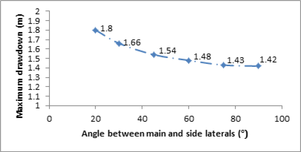
Maximum drawdown versus angle between main and side laterals
4 Discussion
In the first part we evaluated the applicability of unstructured grids for modelling multi-lateral wells as compared to orthogonal structured grids. We conclude that unstructured grids are powerful to model multi-lateral well patterns, because they provide high resolution keeping cell number relatively low by only refining around the wells. However structured grids require very large number of cells to give the desired resolution and suffer from orientation effects if the direction of multi-laterals does not coincide with rows or columns of the model.
The second part aimed to find the optimal configurations for multi-lateral wells by minimizing drawdown near the wellbores. We considered the effect of branch angle and branch length for radial-type and fishbone-type multi-lateral wells. Results suggests that increasing branch length or branch angle will drive configurations towards the optimum as maximum drawdown decreases and the hydraulic head or pressure distribution will be more balanced resulting in lower gradients especially in the close vicinity of the wellbores. Nevertheless we also found that these parameters cannot be “over-increased” as it will give very small incremental advantage.
These conclusions are actually in agreement with the results of other authors although they optimized their models for cumulative production [1, 5, 7, 8].
Ren et al. optimized fishbone wells for coal-bed methane production from Hedong coalfieled in Ordos Basin, North China [5]. They found that gas production increases if branch angle is increased but for angles larger than 55° the incremental production decreases (Figure 9). This is in agreement with Figure 8. where we stated that by increasing branch angle we can maintain the same flow rate at lower drawdown near the wellbore. Similarly, Ren et al. also looked at the effect of branch spacing (Figure 10). which is actually inversely proportional to the length of the main horizontal trunk is constant (smaller branch spacing means more branches).
![Figure 9: The effect of branch angle on cumulative production according to Ren et al. [5].](/document/doi/10.1515/geo-2016-0004/asset/graphic/j_geo-2016-0004_fig_009.jpg)
The effect of branch angle on cumulative production according to Ren et al. [5].
![Figure 10: The effect of branch spacing on cumulative production according to Ren et al. [5].](/document/doi/10.1515/geo-2016-0004/asset/graphic/j_geo-2016-0004_fig_010.jpg)
The effect of branch spacing on cumulative production according to Ren et al. [5].
Considering the aforementioned it can be inferred that Figure 10 – in principle – agrees with Figure 6, demonstrating that decreasing branch spacing or increasing the number of branches respectively have a favourable effect but only up to a certain point as both curves flatten out if spacing is over-decreased or branch number is over-increased respectively.
Comparing the applicability of the two above methods to optimize multi-lateral well patterns (i.e. maximizing cumulative production, and minimizing drawdown near the wellbore as shown in present work) it should be emphasized that although they give similar results their application should depend on the purpose they are used for.
Drawdown minimization cannot quantify the impact of parameter changes as effectively as cumulative production maximization, however it offers a simpler approach from the modelling perspective (steady-state simulation, simpler set of boundary conditions). Consequently results are less accurate but can still give a reasonable approximation of the optimal range. In several cases this will be sufficient.
On the contrary the method of maximizing cumulative production can quantify the effect of different multi-lateral configurations and provides more accurate results. Obviously it presents a more complicated simulation task (transient simulation and more complicated set of boundary conditions are needed). If high accuracy is required, this is the recommended method 13 however it should be noted that high accuracy also demands 13 high level of knowledge about geological conditions and reservoir properties.
Under certain circumstances the minimization of drawdown can be more desirable, for instance in a water-driven hydrocarbon reservoir we can avoid water-coning problems resulting from high drawdown.
5 Conclusion
The increasing use of multi-lateral wells calls for more sophisticated modelling techniques. The first part of this paper presents how effectively unstructured grids can be used to model this type of wells in contrast to structured grids.
In the second part a new approach is introduced to optimize multi-lateral well patterns, namely the minimization of drawdown near the wellbores. Optimization was done by evaluating the effect of branch angle and branch length for radial-type and fishbone-type multilateral wells. By comparison to literature data (where the optimization aimed at maximizing cumulative production) it is concluded that the method presented in this paper will give similar results through a simpler modelling process.
Acknowledgements
We would like to hereby thank our employers, MOL Plc., and University of Szeged for giving us time and support for this study. We also acknowledge the help which the University of Szeged gave us by providing the hardware and software background for our work.
References
[1] Garrouch A.A., Lababidi H.M.S., Ebrahima A.S., An integrated approach for the planning and completion of horizontal and multilateral wells. Journal of Petroleum Science and Engineering, 2004, 44, 283–301.10.1016/j.petrol.2004.03.007Search in Google Scholar
[2] Bajcsi P., Bozsó T., Bozsó R., Molnár G., Tábor V., Czinkota I., et al., New Geothermal Well-Completion and Rework Technology by Laser. Central European Geology, 2015, 58(1–2), 88–99.10.1556/24.58.2015.1-2.6Search in Google Scholar
[3] Slatt R.M., Important Geological Properties of Unconventional Resource Shales. Central European Journal of Geosciences, 2011, 3(4), 435–448.10.2478/s13533-011-0042-2Search in Google Scholar
[4] Torghabeh A.M., Reza Rezaee R., Moussavi-Harami R., Pradhan B., Kamali M.R., Kadkhodaie-Ilkhchi A., Electrofacies in gas shale from well log data via cluster analysis: A case study of the Perth Basin, Western Australia. Central European Journal of Geo-sciences, 2014, 6(3), 393–402.10.2478/s13533-012-0177-9Search in Google Scholar
[5] Ren J., Zhang L., Ren S., Lin J., Meng S., Ren G., Gentzis T., Multi-branched horizontal wells for coalbed methane production: Field performance and well structure analysis. International Journal of Coal Geology, 2014, 131, 52–64.10.1016/j.coal.2014.06.003Search in Google Scholar
[6] Panday S., Langevin C.D., Niswonger R.G., Ibaraki M., Hughes J.D., MODFLOW–USG Version 1: An Unstructured Grid Version of MODFLOW for Simulating Groundwater Flow and Tightly Coupled Processes Using a Control Volume Finite-Difference Formulation. In: U.S. Geological Survey Techniques and Methods, 2013, book 6, chap. A45, 66 p.10.3133/tm6A45Search in Google Scholar
[7] Cai M., Yin H., Zhong H., Fu C., Productivity prediction model and optimal configuration of herringbone multilateral well. Journal of Central South University, 2013, 20, 770–775.10.1007/s11771-013-1547-2Search in Google Scholar
[8] Keim S.A., Luxbacher K.D., Karmis M., A numerical study on optimization of multilateral horizontal wellbore patterns for coalbed methane production in Southern Shanxi Province, China. International Journal of Coal Geology, 2011, 86, 306–317.10.1016/j.coal.2011.03.004Search in Google Scholar
©M. Lux et al., published by De Gruyter Open.
This work is licensed under the Creative Commons Attribution-NonCommercial-NoDerivatives 3.0 License.
Articles in the same Issue
- Special issue: Geomathematical and geostatistical models in geological and environmental case studies
- A Special Issue: Geomathematics in practice: Case studies from earth- and environmental sciences – Proceedings of the Croatian-Hungarian Geomathematical Congress, Hungary 2015
- Special issue: Geomathematical and geostatistical models in geological and environmental case studies
- Modelling of maturation, expulsion and accumulation of bacterial methane within Ravneš Member (Pliocene age), Croatia onshore
- Special issue: Geomathematical and geostatistical models in geological and environmental case studies
- Volume calculation of subsurface structures and traps in hydrocarbon exploration — a comparison between numerical integration and cell based models
- Special issue: Geomathematical and geostatistical models in geological and environmental case studies
- Revisiting the applications of drainage capillary pressure curves in water-wet hydrocarbon systems
- Special issue: Geomathematical and geostatistical models in geological and environmental case studies
- Evaluation and optimization of multi-lateral wells using MODFLOW unstructured grids
- Special issue: Geomathematical and geostatistical models in geological and environmental case studies
- Markov chains and entropy tests in genetic-based lithofacies analysis of deep-water clastic depositional systems
- Special issue: Geomathematical and geostatistical models in geological and environmental case studies
- The application of multivariate data analysis in the interpretation of engineering geological parameters
- Special issue: Geomathematical and geostatistical models in geological and environmental case studies
- Effects of the introduction of pre-treated wastewater in a shallow lake reed stand
- Special issue: Geomathematical and geostatistical models in geological and environmental case studies
- Detecting breakpoints in artificially modified- and real-life time series using three state-of-the-art methods
- Regular Articles
- Model application for rapid detection of the exact location when calling an ambulance using OGC Open GeoSMS Standards
- Regular Articles
- Dynamics of gully side erosion: a case study using tree roots exposure data
- Regular Articles
- The spatial prediction of landslide susceptibility applying artificial neural network and logistic regression models: A case study of Inje, Korea
- Regular Articles
- Effects of land use on chemical water quality of three small streams in Budapest
- Regular Articles
- Identification of mineralized zones in the Zardu area, Kushk SEDEX deposit (Central Iran), based on geological and multifractal modeling
- Regular Articles
- Micro-scale hydrological field experiments in Romania
- Regular Articles
- Integrated Seismic Survey for Detecting Landslide Effects on High Speed Rail Line at Istanbul–Turkey
- Regular Articles
- Environmental impact of the Midia Port - Black Sea (Romania), on the coastal sediment quality
- Regular Articles
- Solid Inclusions in Au-nuggets, genesis and derivation from alkaline rocks of the Guli Massif, Northern Siberia
- Regular Articles
- Circulation types classification for hourly precipitation events in Lublin (East Poland)
- Regular Articles
- Small-scale human-biometeorological impacts of shading by a large tree
- Regular Articles
- The risk of collapse in abandoned mine sites: the issue of data uncertainty
- Regular Articles
- Clay mineralogy of the Boda Claystone Formation (Mecsek Mts., SW Hungary)
- Regular Articles
- Mathematical aspects of the kriging applied on landslide in Halenkovice (Czech Republic)
- Regular Articles
- Campgrounds Suitability Evaluation Using GIS-based Multiple Criteria Decision Analysis: A Case Study of Kuerdening, China
- Regular Articles
- Relationship between landform classification and vegetation (case study: southwest of Fars province, Iran)
- Regular Articles
- Application of multivariate storage model to quantify trends in seasonally frozen soil
- Regular Articles
- Enriching and improving the quality of linked data with GIS
- Regular Articles
- Usability evaluation of centered time cartograms
- Regular Articles
- Modeling of landslide volume estimation
- Regular Articles
- Modelling the geomorphic history of the Tribeč Mts. and the Pohronský Inovec Mts. (Western Carpathians) with the CHILD model
- Regular Articles
- Črvenka loess-paleosol sequence revisited: local and regional Quaternary biogeographical inferences of the southern Carpathian Basin
- Regular Articles
- Preliminary paleoecological reconstruction of long-term relationship between human and environment in the northern part of Danube-along Plain, Hungary
- Regular Articles
- Analytical fundamentals of migration in reflection seismics
- Regular Articles
- Geohazards (floods and landslides) in the Ndop plain, Cameroon volcanic line
- Special Issue: Applications and Research Trends in Remote Sensing and Geoinformation - Third International Conference on Remote Sensing and Geoinformation of Environment - RSCy2015
- Incidence angle normalization of Wide Swath SAR data for oceanographic applications
- Regular Articles
- Assessment of future scenarios for wind erosion sensitivity changes based on ALADIN and REMO regional climate model simulation data
- Regular Articles
- Wavelet analysis of low-frequency variability in oak tree-ring chronologies from east Central Europe
- Regular Articles
- Geostatistical study of spatial correlations of lead and zinc concentration in urban reservoir. Study case Czerniakowskie Lake, Warsaw, Poland
- Regular Articles
- An interactive tool for semi-automatic feature extraction of hyperspectral data
- Regular Articles
- Structural composition of organic matter in particle-size fractions of soils along a climo-biosequence in the main range of Peninsular Malaysia
- Regular Articles
- Tilt offset associated with local seismicity: the Mt. Etna January 9, 2001 seismic swarm.
- Regular Articles
- An improved method for estimating in situ stress in an elastic rock mass and its engineering application
- Regular Articles
- NEHRP Site Classification and Preliminary Soil Amplification Maps of Lamphun City, Northern Thailand
- Regular Articles
- Spatial Analysis of b-value Variability in Armutlu Peninsula (NW Turkey)
- Regular Articles
- Linked Forests: Semantic similarity of geographical concepts “forest”
- Regular Articles
- The Uniqueness of Planktonic Ecosystems in the Mediterranean Sea: The Response to Orbital- and Suborbital-Climatic Forcing over the Last 130,000 Years
- Regular Articles
- The current state of the creation and modernization of national geodetic and cartographic resources in Poland
- Regular Articles
- Variability of seasonal and annual precipitation in Slovenia and its correlation with large-scale atmospheric circulation
- Regular Articles
- Mineralogical and chemical characteristics of a powder and purified quartz from Yunnan Province
- Regular Articles
- Geometry, kinematics and dynamic characteristics of a compound transfer zone: the Dongying anticline, Bohai Bay Basin, eastern China
- Regular Articles
- Determination of aquifer parameters using geoelectrical sounding and pumping test data in Khanewal District, Pakistan
- Regular Articles
- Post-Earthquake People Loss Evaluation Based on Seismic Multi-Level Hybrid Grid: A Case Study on Yushu Ms 7.1 Earthquake in China
- Regular Articles
- Dem Local Accuracy Patterns in Land-Use/Land-Cover Classification
- Regular Articles
- Dynamics of development and variability of surface degradation in the subalpine and alpine zones (an example from the Velká Fatra Mts., Slovakia)
- Regular Articles
- Relationship between high-frequency sediment-level oscillations in the swash zone and inner surf zone wave characteristics under calm wave conditions
- Regular Articles
- Uncertainty assessment based on scenarios derived from static connectivity metrics
- Regular Articles
- Re-discussion on the detrital zircon provenance of the lower Yanchang Formation in the southern Ordos Basin
- Special Issue: Applications and Research Trends in Remote Sensing and Geoinformation - Third International Conference on Remote Sensing and Geoinformation of Environment - RSCy2015
- Special Issue: Applications and Research Trends in Remote Sensing and Geoinformation - Third International Conference on Remote Sensing and Geoinformation of Environment - RSCy2015
- Special Issue: Applications and Research Trends in Remote Sensing and Geoinformation - Third International Conference on Remote Sensing and Geoinformation of Environment - RSCy2015
- Maritime Spatial Planning in Cyprus
- Special Issue: Applications and Research Trends in Remote Sensing and Geoinformation - Third International Conference on Remote Sensing and Geoinformation of Environment - RSCy2015
- Digital mapping of corrosion risk in coastal urban areas using remote sensing and structural condition assessment: case study in cyprus
- Special Issue: Applications and Research Trends in Remote Sensing and Geoinformation - Third International Conference on Remote Sensing and Geoinformation of Environment - RSCy2015
- A Proposal of a Mass Appraisal System in Greece with CAMA System: Evaluating GWR and MRA techniques in Thessaloniki Municipality
- Special Issue: Applications and Research Trends in Remote Sensing and Geoinformation - Third International Conference on Remote Sensing and Geoinformation of Environment - RSCy2015
- Integrating weather and geotechnical monitoring data for assessing the stability of large scale surface mining operations
- Special Issue: Applications and Research Trends in Remote Sensing and Geoinformation - Third International Conference on Remote Sensing and Geoinformation of Environment - RSCy2015
- Detection of olive oil mill waste (OOMW) disposal areas using high resolution GeoEye’s OrbView-3 and Google Earth images
- Special Issue: Applications and Research Trends in Remote Sensing and Geoinformation - Third International Conference on Remote Sensing and Geoinformation of Environment - RSCy2015
- FLIRE DSS: A web tool for the management of floods and wildfires in urban and periurban areas
- Special Issue: Applications and Research Trends in Remote Sensing and Geoinformation - Third International Conference on Remote Sensing and Geoinformation of Environment - RSCy2015
- A hybrid downscaling approach for the estimation of climate change effects on droughts using a geo-information tool. Case study: Thessaly, Central Greece
- Special Issue: Applications and Research Trends in Remote Sensing and Geoinformation - Third International Conference on Remote Sensing and Geoinformation of Environment - RSCy2015
- Comparison of MODIS 250 m products for early corn yield predictions: a case study in Vojvodina, Serbia