3D Modelling as an Effective Way to Visualize the Archaeological Monument with the Sequential Changes: A Case Study on the Itakhola Mound Temple
-
Nazmul Alam Ridoy

 und
Mohammad Mahmudul Hasan Khan
und
Mohammad Mahmudul Hasan Khan

Abstract
Three-dimensional (3D) modelling is an efficient technique for preserving visual archaeological legacy by offering chronological evidence of architectural alterations. This research used a mixed-methods approach to explore the Itakhola Mound Temple, particularly its five phases, as a notable archaeological site in the Lalmai-Mainamati Hill region of the Cumilla district, Bangladesh. All the available evidence and field observations suggest that the highest reconstruction phase is situated above the other four phases. Consequently, only the fifth phase is observable, as opposed to the others. To render all phases visibly, the solid 3D model has been generated utilizing several software tools, for example, Autodesk AutoCAD, 3D Studio Max, and Adobe Photoshop. These elucidated the chronological architectural modifications of the temple and the likely reasons for these alterations. This research elucidates the rationale for choosing solid modelling over photogrammetry or laser scanning methods, as well as the alterations in measurement over several phases. This study emphasizes the significance of virtual preservation, specifically concerning temple architecture only, rather than environmental elements. This demonstrates that 3D solid modelling functions as a sustainable digital approach for the virtual preservation and representation of archaeological monuments, thereby aiding future investigations and conservation efforts.
1 Introduction
History entails the analysis of previous events to understand the importance and interrelations of causality in the overall development of human societies (Nasson 2002, 651). History and archaeology facilitate our understanding of the past, and the study of historical events can influence our perspectives in various ways. Itakhola Mound Temple is an ancient monument and one of the most significant sites in the Lalmai-Mainamati Hill region, a UNESCO tentatively listed area in the Cumilla district of Bangladesh (Alam et al. 2021, 93–103; Monsor 2014; Huda et al. 2021). It comprises five phases of reconstruction. Currently, only the upper or fifth phase is observable. The remaining four stages are subordinate to the upper or fifth phase.
The primary objective of this study is to attain an initial comprehension of the procedures involved in solid 3D modelling for archaeological applications, including an observation of the various reconstruction phases of structural forms in three-dimensional (3D) representation, the alterations that have occurred, and the reasons behind them. The study relies on solid/geometric 3D modelling instead of photogrammetry and laser scanning, emphasizing the justification of this approach that is described in detail in Section 3. This research highlights the significance of virtual preservation in archaeology. However, the virtual preservation focuses solely on the temple architecture, neglecting the surrounding environmental features such as trees, plants, rivers, roads, etc. In the absence of data concerning the natural environment’s characteristics, the emphasis is solely on architectural modifications and their underlying causes; no flora or additional elements were incorporated into the models during the 3D reconstruction. These models can significantly aid preservation via digital documentation, comparative study, and future reutilization for additional analysis.
This study presents a virtual structure illustrating the extent of the portion that has been developed or reconstructed across five phases, along with the rationale for each phase. It is to be mentioned that the temple was not fully reconstructed virtually, from the foundation to the roof, along with the old environment, due to the lack of conclusive documentation. Concerning the excavation report of Rahman (1992), entitled Itakhola Bihar (7tom-13sho Sotok Porzonto Bouddha Sabbhatar Nidorshon) [Itakhola Vihar (Buddhist Civilisation Monuments of till 7th to 13th Century)], all the three-dimensional representations have been developed that predominantly depict the five distinct phases of the temple’s architecture and the methodology of solid 3D virtual reconstruction of archaeological evidence.
As of now, no published research work has been found that utilizes 3D solid modelling methodologies for the Itakhola Mound Temple. However, a more effective understanding of archaeology has been facilitated by the use of three-dimensional models, which has been reflected in several research studies globally, including but not limited to the study of Ferdani et al. (2020); Remondino and Campana (2014); Zvietcovich et al. (2015); Sulistyani (2024); Rahtz and Reilly (2003); Khan and Huda (2023); Arias et al. (2022). This section provides a concise literature review of diverse 3D heritage modelling initiatives that have utilized solid modelling techniques in the Bangladesh context, as the study’s objective transcends merely visualizing the five transitional stages to include an understanding of the underlying causes of these shifts. Rahman et al. (2008) identified three techniques for 3D modelling: geometric modelling, photogrammetry, and laser scanning. They sought to elucidate the ramifications of the solid modelling method while succinctly alluding to the other two ways. Nevertheless, it did not assess the efficacy, in the context of the hidden or covered structure, of the solid modelling technique in comparison to the other two. Rahaman and Sharma (2005) asserted that all three types of digital documentation are appropriate in various situations. The solid modelling technique has been utilized in multiple research projects by Imran and Masud (2016, 2021a, 2021b). The methodology was applied in the UNESCO World Heritage site of the Shait Gumbad Mosque Region during the research completed in 2016 and 2021. Similarly, they utilized the identical methodology in their 2021(a) study, which concentrated on another UNESCO World Heritage site, the Paharpur Buddhist Vihara in Bangladesh. Conversely, Hasan (2025) developed a virtual model of the Chhoto Sona Mosque and subsequently converted it into a Virtual Reality platform. Elsewhere, Naqi et al. (1999) produced an intricate virtual reconstruction of the Paharpur Buddhist Vihara. Unlike the studies by Imran and Masud (2016, 2021b), they offered a different viewpoint and enhanced depth about the development of the solid model.
The study is anticipated to facilitate a clearer understanding of phase-by-phase structural changes and their underlying causes. This will demonstrate the significance of hand 3D solid modelling for archaeological applications.
2 The Three-dimensional Representation
Three-dimensional, or 3D, denotes possessing or seeming to possess three dimensions (length, breadth, and height), thus creating a realistic appearance (Cambridge Dictionary, 2025, “Three-dimensional”). We belong in a three-dimensional environment (Ware 2022; Wenjun 2008, 546). The physical world and all observable entities inside it are three-dimensional (Barney and Sheldon n.d.). The brain interprets three-dimensional images by integrating many depth signals, including binocular disparity, motion parallax, occlusion, relative size, texture gradients, aerial perspective, accommodation, and convergence. Binocular disparity greatly affects depth perception at close range; nevertheless, at extended distances, alternative cues become more salient (Cutting and Vishton 1995).
The three-dimensional methodology has become prevalent in contemporary archaeological work. Research conducted by Grosman et al. (2014), Forte (2014), and Imran and Masud (2016), among others, demonstrates the application of 3D technology in archaeology. 3D models are unequivocally advantageous for public engagement, digital preservation, and educational objectives (Waagen 2019, 12). The 3D dataset is more effective for archaeological documentation and assessment than 2D raster photographs. 3D data can effortlessly scale, rotate, and be seen from any direction and angle. The generation of three-dimensional data through laser scanning, structured light scanning, or image-based modelling contributes to the virtual preservation of artefacts and facilitates public dissemination online (Trognitz et al. n.d.). However, we must keep caution in the creation of a 3D model, ensuring that our modelling appropriately represents the structured design by the architects.
3 Rationale for Applying Solid Modelling
3D modelling encompasses conventional methodologies employed in historical research prior to the advent of computer-aided visualization tools (Muenster 2022, 10). Various prevalent methods exist globally for the three-dimensional documentation of archaeological data or any item in computer-aided modelling. Rahman et al. (2008) identified three ways for three-dimensional recording, as seen in Figure 1.
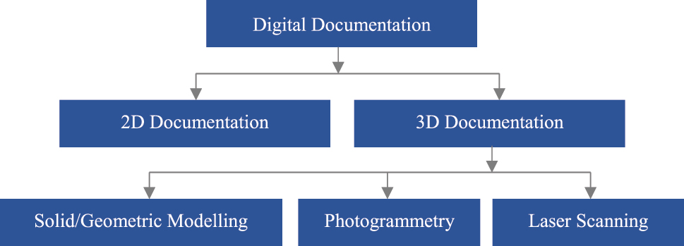
Various procedures and techniques for digital documentation (Rahman et al. 2008, 83).
Rahaman and Sharma (2005) assert that geometric modelling, photogrammetry, and laser scanning are all suitable methodologies for digital documentation in various situations (Rahman et al. 2008, 84). Laser scanners function by projecting a series of laser beams onto an object’s surface, while photogrammetry is the field dedicated to acquiring accurate measurements using photos. It also functions as a method for constructing three-dimensional representations of objects (Wyatt-Spratt 2018). It is noteworthy that laser scanning instruments are significantly more expensive than photogrammetry, yet they yield metrically precise data (Münster et al. 2024, 108). Conversely, Feng (2015) asserts that 3D solid modelling involves delineating the orientation of objects in relation to the plane model. This modelling technology employs fundamental elements such as wedges, rectangles, and cylinders to depict objects by their intersection, parallelism, and difference. It can compute mass, centroid, volume, moment of inertia, and form as well.
The selection of solid modelling for the three-dimensional recording of the Itakhola Mound Temple was based on its effectiveness in fulfilling the architectural virtual reconstruction needs of the site. The temple consists of five sequential reconstruction phases, each built upon the preceding phase. Currently, only the fifth phase is observable. Given that the early phases are no longer directly observable, solid and geometric modelling was chosen for its ability to recreate concealed structures, as this method allows for manual 3D modelling from a singular solid object. The solid modelling technique has been employed in many investigations of ancient monuments in Bangladesh (Imran and Masud 2016; 2021a; 2021b).
Photogrammetry and laser scanning are efficient techniques for documenting the surface details of well-preserved structures (Zvietcovich et al. 2015); however, they face limitations in cases of erosion, obscured geometries, and the necessity for hypothetical reconstruction, challenges that are evident at the Itakhola Mound Temple. Subsequently, following the creation of the 3D model by photogrammetry or laser scanning to reconstruct the fractured or obscured section, geometric modelling must be employed. These two technologies are limited to recording the external surface of an object or scene and are unable to scan the internal structure. Consequently, solid modelling excels in conceptualizing idealized geometric concepts from insufficient data. This method enables the rebuilding of collapsed or hidden architectural features via logical deductions and parametric models. These characteristics make it the most appropriate choice for the reconstruction-based documentation of the culturally significant site, Itakhola Mound Temple.
Notably, both Autodesk software and open-source software are applicable for this type of documentation. It is feasible for individuals to utilize open-source or free software for this purpose. Blender is a widely utilized free software application for 3D modelling. Conversely, LibreCAD serves as an open-source substitute for Autodesk AutoCAD. Photopea, a free software sponsored by commercials, offers a premium subscription devoid of ads, serving as an alternative to Adobe Photoshop.
4 Itakhola Mound Temple as the Case Study
Itakhola Mound is an archaeological site located in Lalmai-Mainamati hill or ancient Devaparvata, Cumilla, Bangladesh, as indicated on the map (Figure 2). An aerial photograph depicting the top view from Alam (2024) has been incorporated as Figure 3. The location is positioned 1.5 km north of Shalban Vihara. The geographical coordinates of the temple are 23°26′20.09″ N, 91°07′45.43″ E. Itakhola Mound is historically significant as a site for the extraction of ancient bricks, which is the origin of its name (Rashid 2021; Qadir 1997, 105). A large stupa complex with an adjoining monastery was discovered following the excavations. It approximately originates from the seventh to eighth century CE (Cattagram Bibhager Sangrakhita Ghosita Purakirtir Talika [List of Declared Antiquities of Chittagong Division] 2021, 4). In the area, two separate locations are designated as Itakhola Mound (Begum 2010, 49). The initial site, sometimes referred to as Boro (Big) Itakhola Mound, is universally acknowledged as the Itakhola Mound, the focal point of this study. The second site, referred to as Choto (Little) Itakhola Mound, remains unexcavated as of 2025 (Ridoy 2025, lii–liii). Furthermore, it is situated at the pinnacle of the hill range that stretches along the western perimeter of the Lalmai peak (Morrison 1974, 59). At the case study site, comprehensive excavations uncovered five separate phases of reconstruction, each adding an additional floor, culminating in the main route reaching a total of 12 storeys (Imam 2000, 55). Adjacent to the temple, a Buddhist Vihara (monastery) is located roughly 45 m north of the shrine (Rahman and Alam 2023, 35–36). Furthermore, its substantial dimensions as a temple and its central position amidst the architectural landscape of the mountainous region signify its role as a catalyst for the emergence of a millennium of civilization in the Lalmai-Mainamati area (Rahman 1992, 28–29).
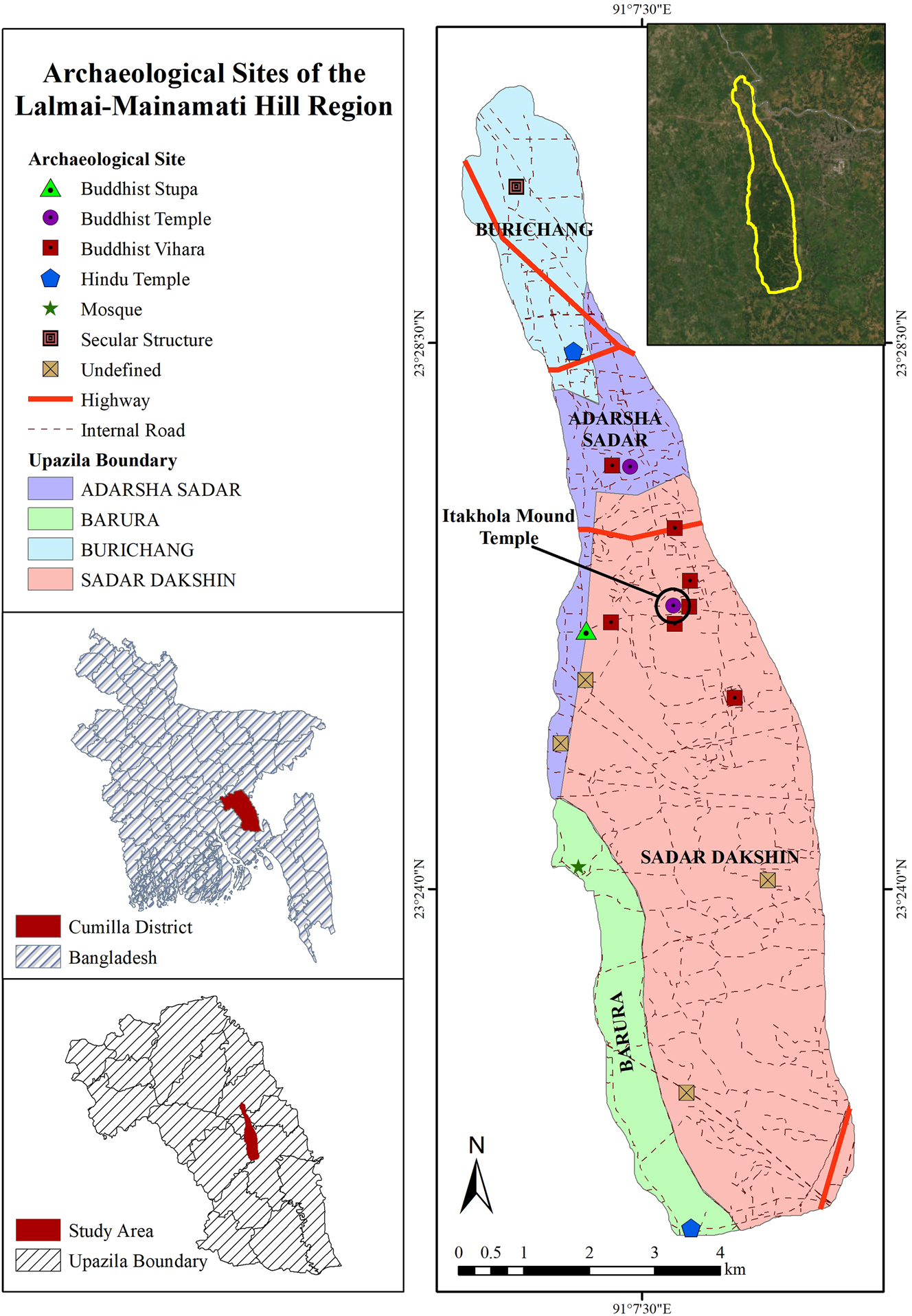
The location of the Itakhola Mound Temple is indicated on the map of archaeological sites in the Lalmai-Mainamati Hill region, modified after Ridoy (2023, 5).
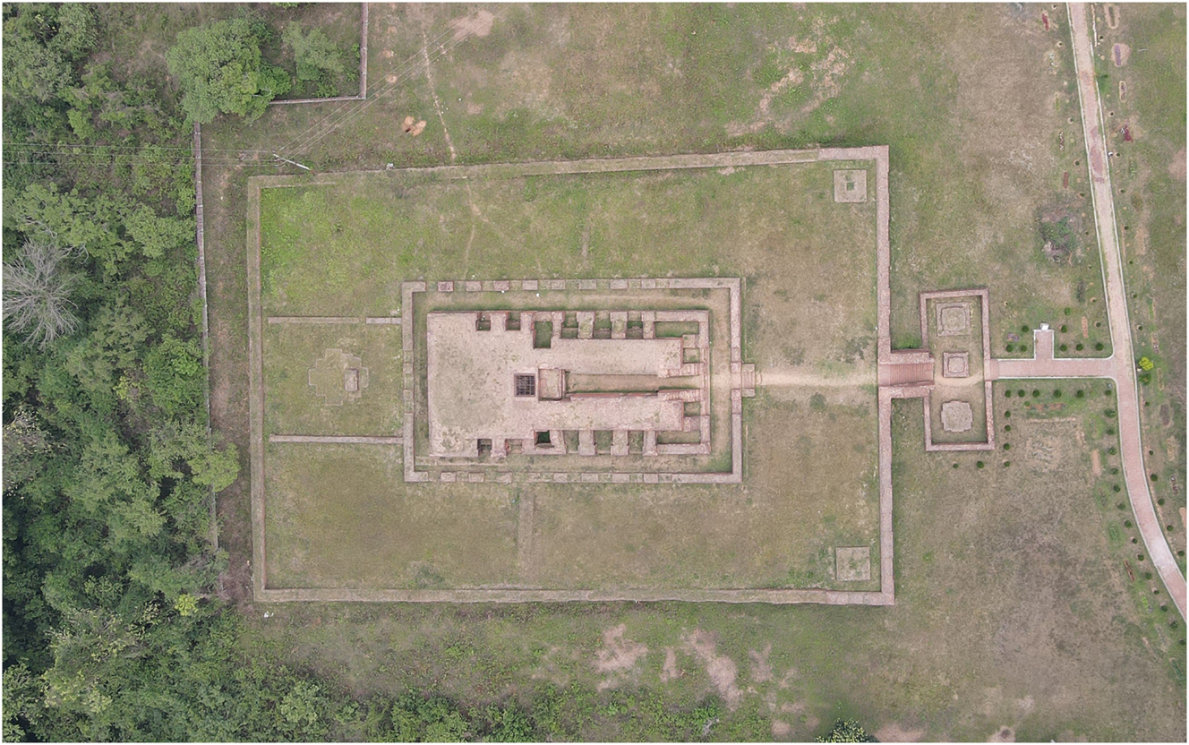
Aerial photograph of the Itakhola Mound temple; source: Alam (2024).
The selection of the Buddhist temple for 3D representation is influenced by various characteristics. Firstly, Itakhola Mound is distinguished by its single-temple architecture. Researchers contend that it is among the earliest medieval edifices in the region. Five phases of its reconstruction have been identified (Begum 2010, 36; Rashid 2021). Nevertheless, as one phase is constructed upon another, revealing and examining the lower layer is impossible without dismantling the upper layer. 3D documentation has been conducted, emphasizing the virtual representation of the five reconstruction phases.
Secondly, if safeguarding the Itakhola Mound temple from degradation is unfeasible for any reason, then three-dimensional documentation and virtual reality may serve as the sole effective means to display the object to future generations. Archaeological features may be obliterated by both natural and anthropogenic factors. Under these conditions, the utilization of 3D and virtual reality is crucial for safeguarding data on the location.
5 Methodology and Results
5.1 Methodology
5.1.1 Structured Workflow
To comprehend the modifications in the reconstruction phases during the creation of the 3D model, a systematic technique has been employed, with the sequential procedure outlined below.
5.1.1.1 Conducting Literature Reviews and Fieldwork
Almost all bibliographic data concerning Itakhola Mound was gathered in the preliminary phase, which has become the basis for ensuing works. The excavation report of Rahman (1992), published by the Department of Archaeology (DoA), was selected as the primary source for this task. Simultaneously, diverse data has been gathered and evaluated by remote sensing techniques. This involved the analysis of satellite data, together with maps produced at various intervals, among other resources. Fieldwork was performed on several occasions, during which measurement data from the excavation report was verified and corrected using the survey form. Moreover, relevant images were taken throughout the field activities.
5.1.1.2 Ground Plan Digitalization (2D Documentation)
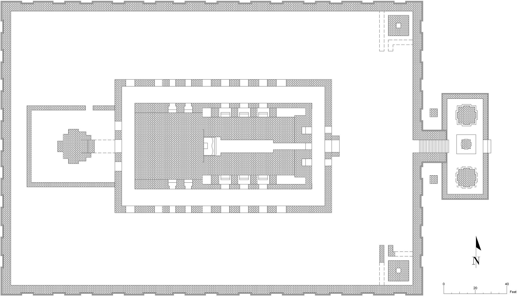
The ground plan serves as the essential blueprint for a building structure. It is generally built from the utmost vantage point. The observation of the two-dimensional blueprint provides clarity into the actual characteristics of the structure as it will manifest in reality. To prepare a 3D model of an existing structure, it is important to first develop an appropriate 2D ground plan to ensure accurate dimensions. At this stage, five unique ground plan designs are necessary to develop the incremental model of the Itakhola Mound. The excavation report’s primary source was employed for this purpose. All five phases of hand-drawn ground plans attached in the excavation report have been redrawn in a two-dimensional manner using Autodesk AutoCAD software (Figure 4). This established the basis for later three-dimensional endeavors.
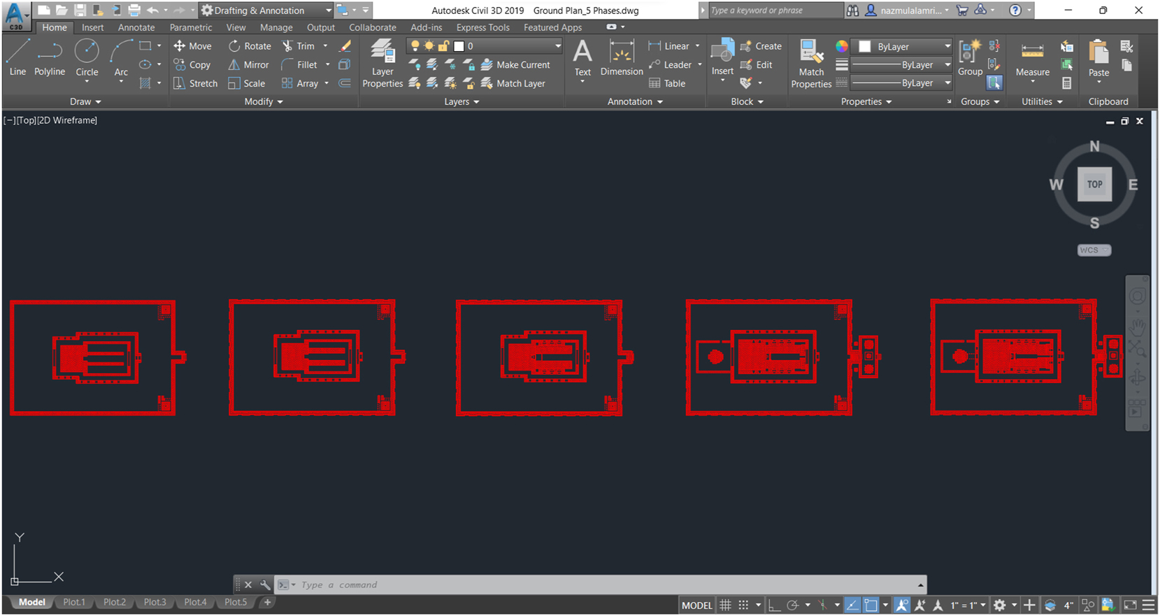
Redrawn of the ground plan for the five phases of the Itakhola Mound Temple utilizing Autodesk Civil 3D as AutoCAD.
5.1.1.3 Texture Preparing Process
Textures are applied to add a realistic appearance to three-dimensional solid models. This primarily denotes a pixel-based image derived from the real component of a structure or ancient structures. Two textures are employed in the models. One texture pertains to the wall, namely brick, while the other pertains to the surface texture, which is grass. It is recommended to alter them before integrating them as bitmaps into the 3D model’s material. Therefore, the outcomes are anticipated to be comparatively advantageous. The material of the Itakhola Mound Temple has been modified utilizing Adobe Photoshop software (Figure 5). The perspective texture images have been modified, and their flaws have been rectified. Thereafter, modifications to brightness and contrast were executed and exported in .jpg format.
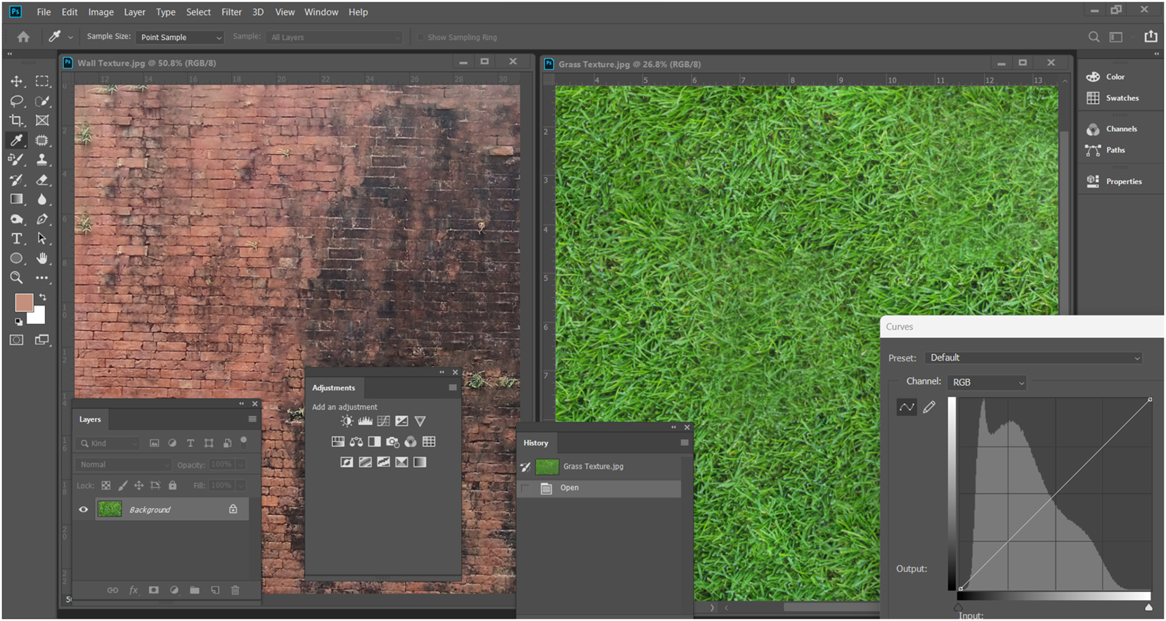
Texture editing by Adobe Photoshop.
5.1.1.4 3D Elevation’s Height Determination
The temple’s total height is approximately 20 feet, and the five phases that were built and renovated will be specifically discussed in the two sample section drawings included in the report. The dimensions of the two sample section drawings mentioned in the excavation report were employed to determine the height of the 3D models. Further information is illustrated in Figures 6 and 7. The section drawings referenced in the report are hand-drawn and not to scale. To ensure the precision of the 3D model, these have been redrafted in AutoCAD to scale. The dimensions of the parts were further validated by field activities. The heights of the five phases in the central worship house part are measured from bottom to top as follows: 2 feet 10 inches; 3 feet; one foot 6 inches; one foot 1 inch; and 7 feet 9 inches, respectively. The fifth phase is noted to have been constructed at a somewhat greater height. Conversely, the dimensions of the main entrance part are 2′7″, 3′3″, 2′3″, 1′3″, and 1′5″, summing to a total of 10′9″; and the data pertaining to the reconstruction of the second phase was very substantial.
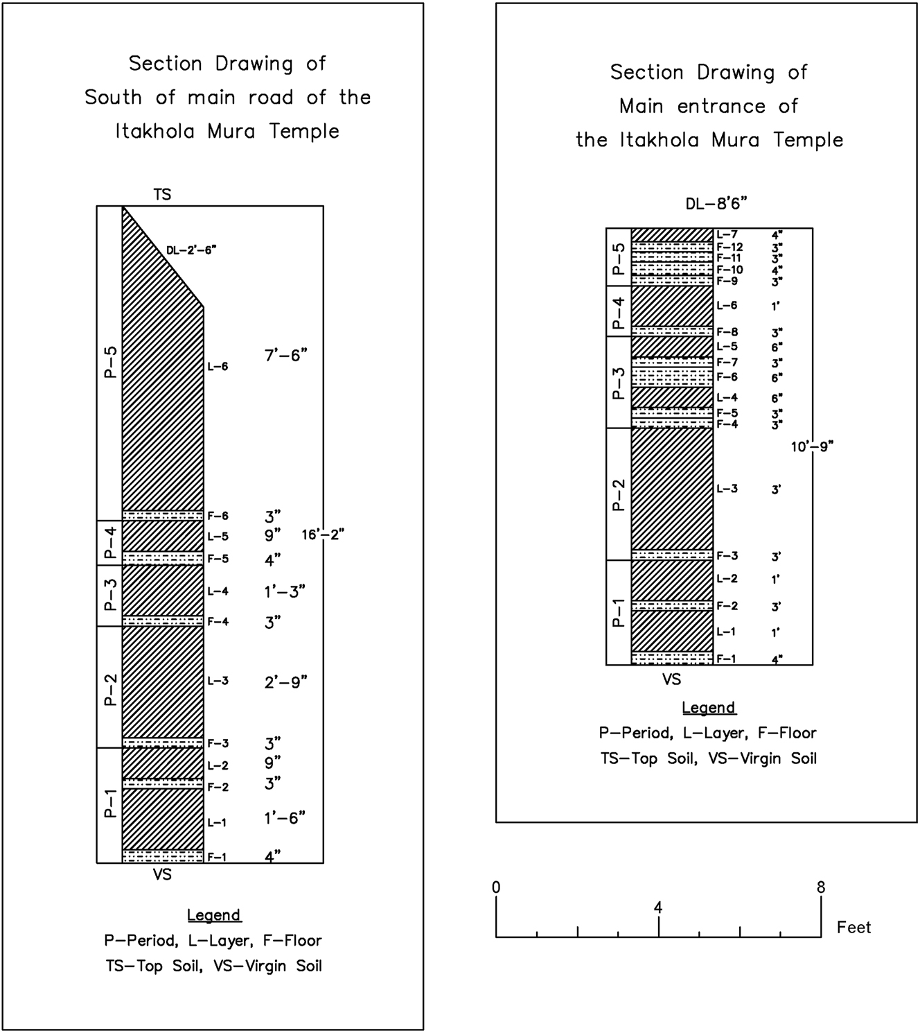
Digitized section drawing of the Itakhola Mound using AutoCAD, modified after Rahman (1992, 19–20).
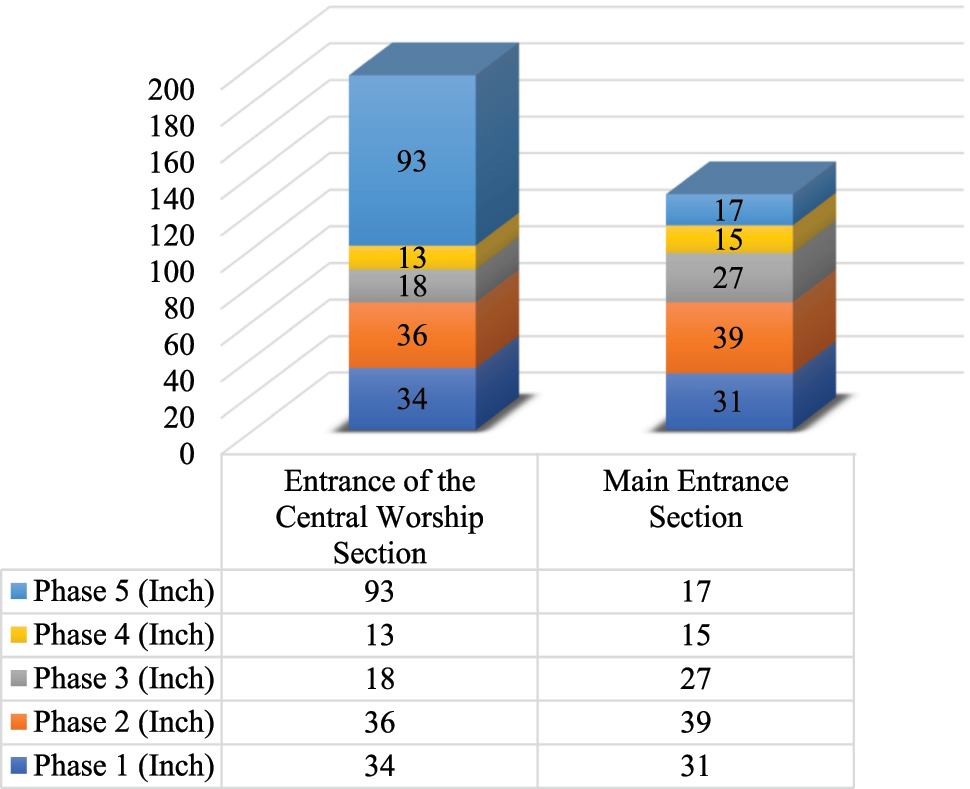
The 3D stacked column chart displays the measurement of the entrance of the central worship section and the main entrance section of the temple from the redrawing in inches.
The measurements of the period-specific layers for both the main entrance and the entry to the central worship house, as indicated in the section sketch, have been employed to create the 3D models.
5.1.1.5 Creating 3D Model
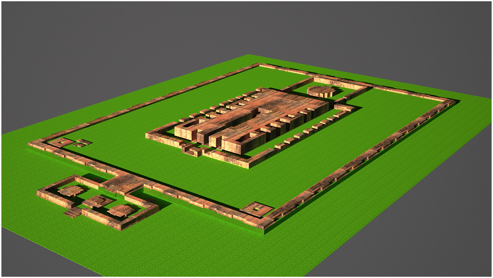
3D Studio Max, a prominent software tool of Autodesk, is employed for the construction of 3D models. Digitized ground plans were exported from AutoCAD in .dwg format and later integrated into 3D Studio Max. The 3D model has been created using the soil/geometric method, which relies on the ground plans (Figure 8). Initially, it existed in a solid state; however, further efforts were made to realize it by integrating texture. The Vray Sun and Vray Camera are separately tuned for each phase model within the environmental conditions to enhance output quality. In the concluding phase, high-resolution photos were exported in .jpg format using Vray rendering tools.
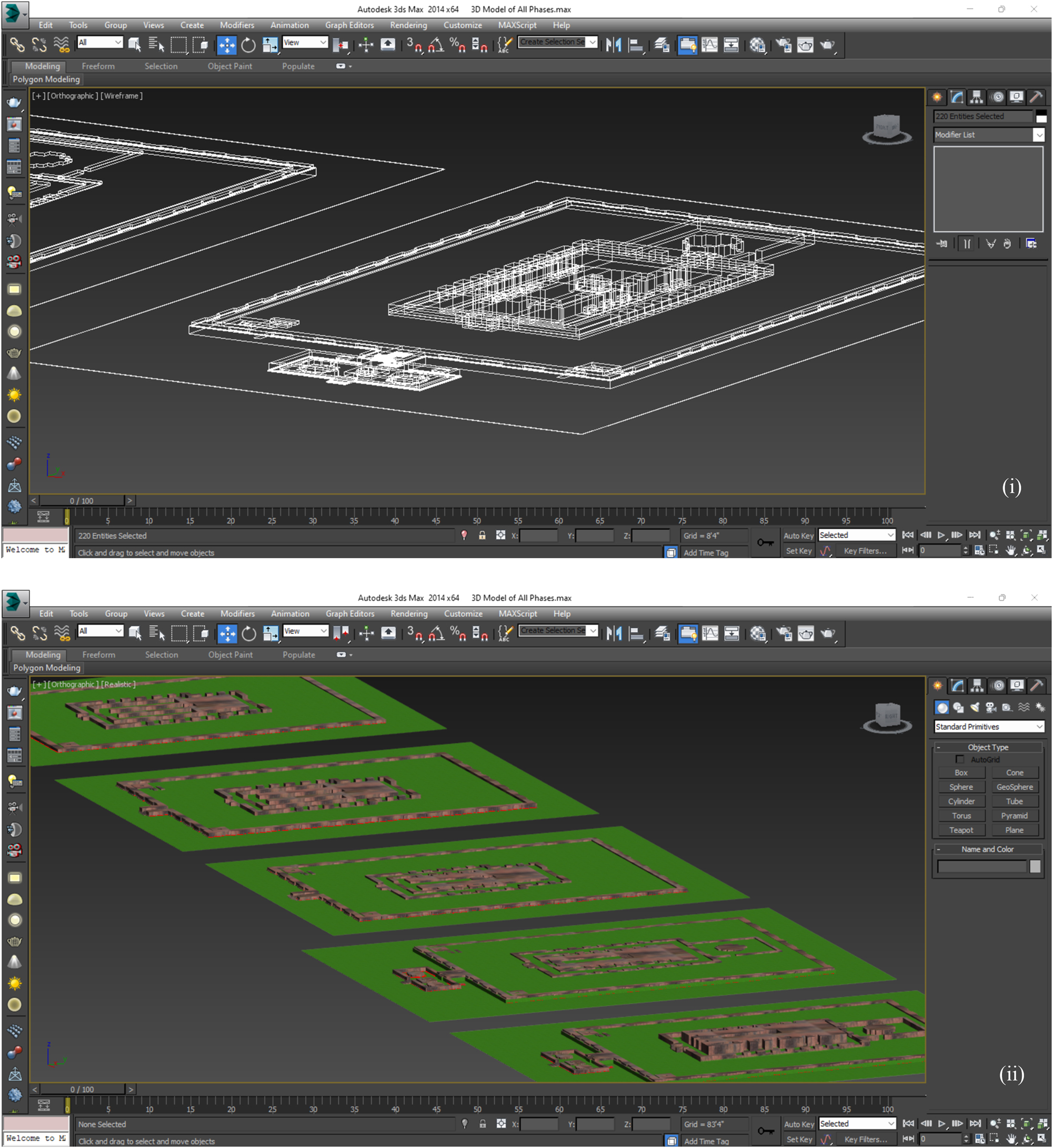
Using autodesk 3D Studio Max, the 3D models of five phases were created; (i) 2D wireframe, (ii) 3D mesh model with texture.
5.2 Results
The main goal of observing the aforementioned procedures is to create a nearly accurate understanding of the five separate phases of change: enhancement, addition, subtraction, and their potential causes. A concise overview of each reconstruction phase is presented below, using the ground plan and three-dimensional models. These descriptions are crucial for a good understanding of the modifications associated with the produced 3D digital model.
5.2.1 First Reconstruction Era (Figures 9 and 10)
In the excavation report, Rahman (1992, 14–17) states that a sculpture cell, measuring 8′ × 7′, is positioned centrally on the east wall of a 43′ × 43′ structure. A 64′-6″ eastern corridor with 5′-3″ wide walls connects the cell, signifying its existence since the first phase. The 8′-6″ wide circumferential path was surrounded by walls measuring 3′-9″ to 4′ in thickness (82′ × 136′-6″), with post holes and straw roofing. The complete temple, including the residential section (?), logical argument provided in the discussion section, measures 43 feet × 111 feet 6 inches. Fully excavating the first era necessitates the removal of subsequent constructions. A 6-foot open square encircles the barrier (162 feet × 182 feet 10 inches), and 13-foot × 13-foot corner elements may have served as toilets or stupas, as argued in the discussion section.
Digitized ground plan of the first phase of the Itakhola Mound Temple, modified after Rahman (1992, 13).
Created 3D model of the first phase of Itakhola Mound Temple.
5.2.2 Second Reconstruction Era (Figures 11 and 12)
According to Rahman (1992, 17–22), the second reconstruction preserved the layout of the initial era. A new 3′3″ wall expanded the main road’s flanks to 8′3″, decreasing the monks’ residential area (?) from 12′9″ to 9′6″. Substantial pots and plates remnants on the third-level floor (elevated by 1′) confirm occupancy. The outside wall’s breadth diminished from 6 feet to 5 feet internally, with two external bands and central panel embellishment, which is the sole ornamental element identified. No terracotta plaques or ornaments were found. The main temple wall stands at a height of 16–17 feet. The first two floors reached the initial wall; only the third stretched to the subsequent wall.
Digitized ground plan of the second phase of the Itakhola Mound Temple, modified after Rahman (1992, 16).
Created 3D model of the second phase of Itakhola Mound Temple.
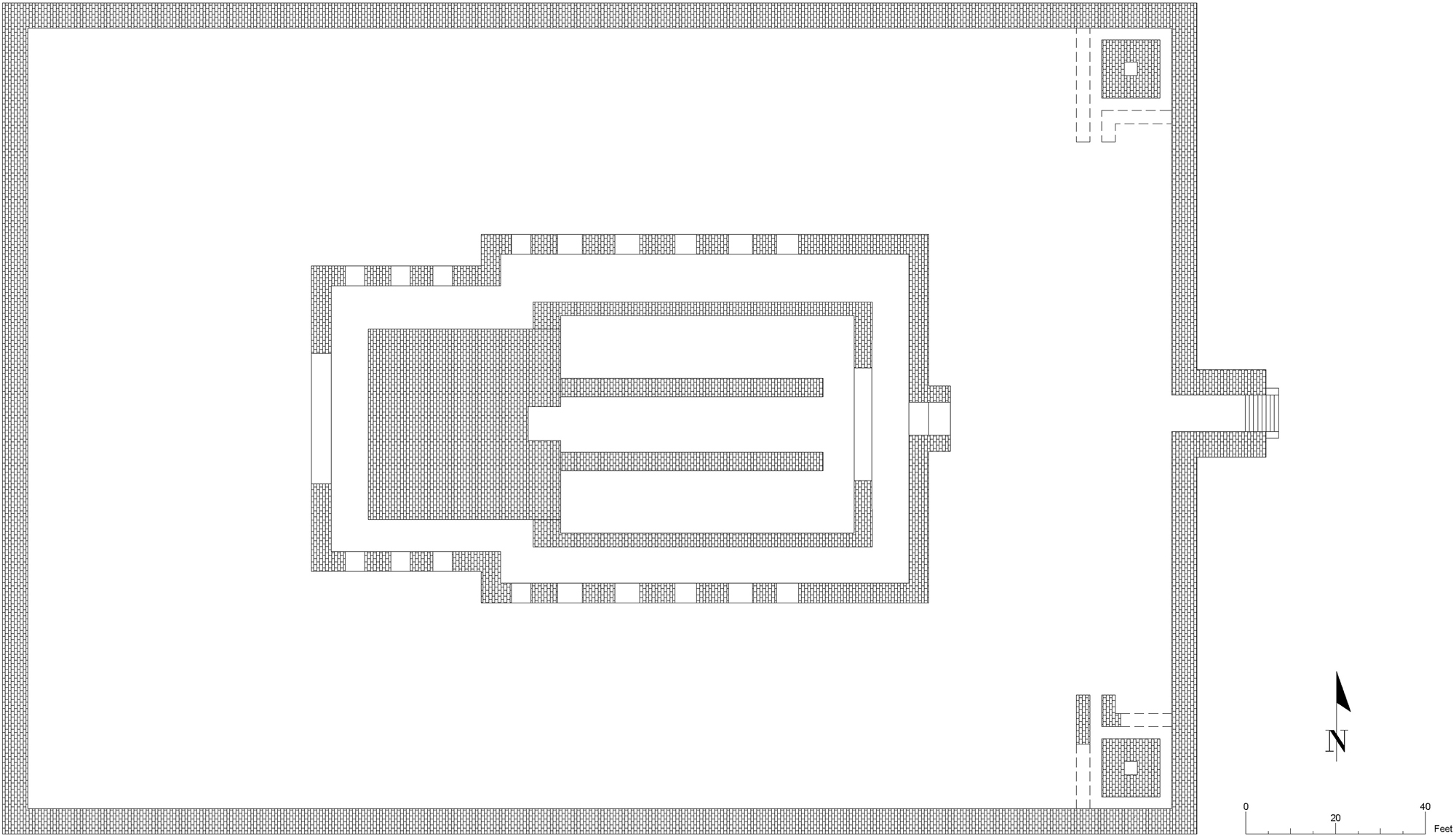
5.2.3 Third Reconstruction Era (Figures 13 and 14)
Rahman (1992, 22–23) indicates that the third reconstruction underwent significant alterations. A 3-foot wall was constructed adjacent to the monk quarters (?) on either side of the main path, resulting in a total width of 11 feet 3 inches, therefore enclosing the monk quarters (?) area. The fourth storey, reaching the third wall, validates this closure. The Akshobhya idol, measuring 7 feet, 5 feet, and 3 feet above the first, second, and third floors, respectively, was constructed on a 2-foot-high platform including an arched sewer. Twelve stories were identified on the primary eastern entrance, but only five were located along the circumferential route. It is to think that the stupa-like edifices, mentioned in the first era, were additionally incorporated at the corners in this phase.
Digitized ground plan of the third phase of the Itakhola Mound Temple, modified after Rahman (1992, 21).
Created 3D model of the third phase of Itakhola Mound Temple.
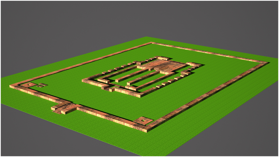
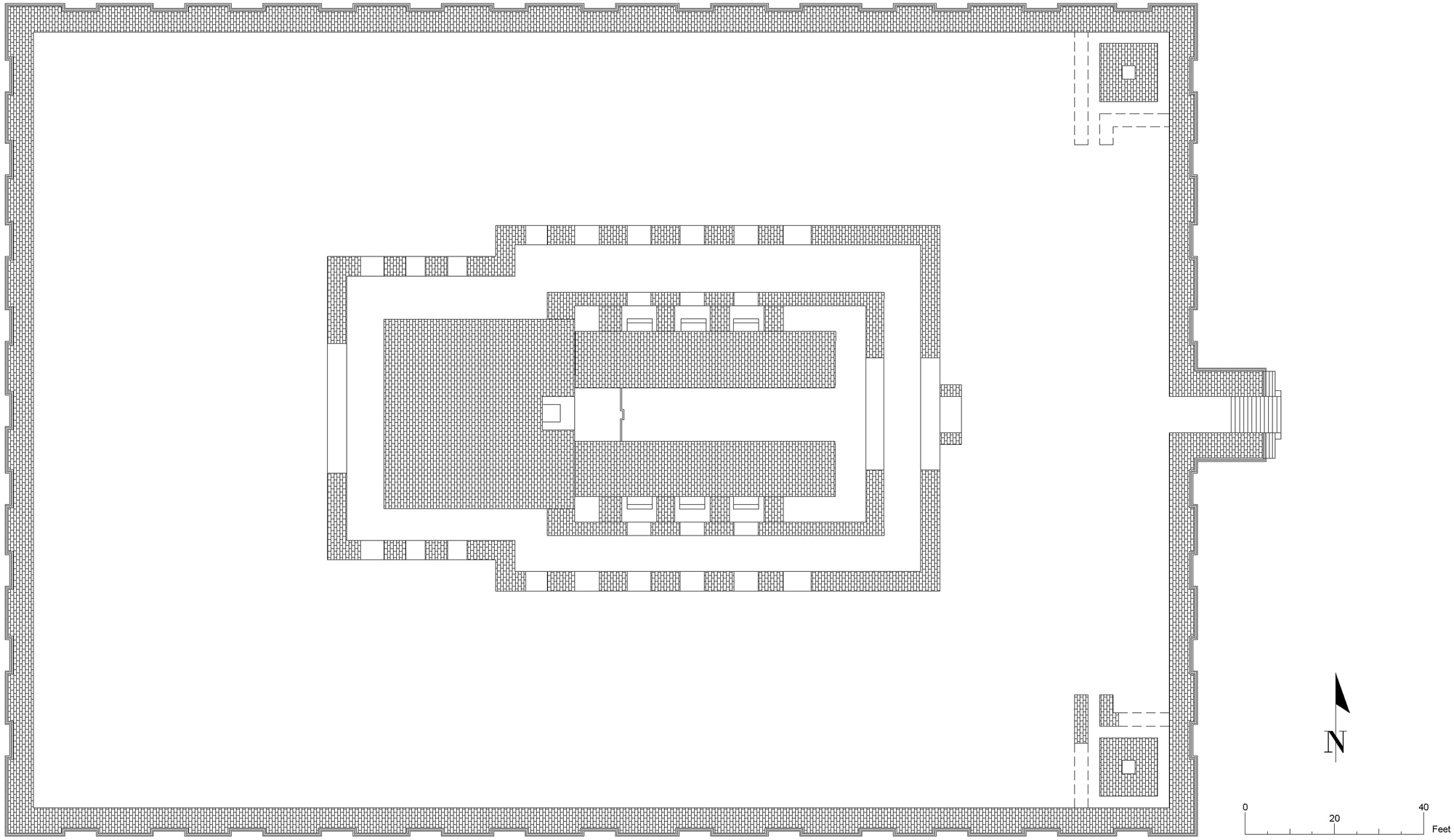
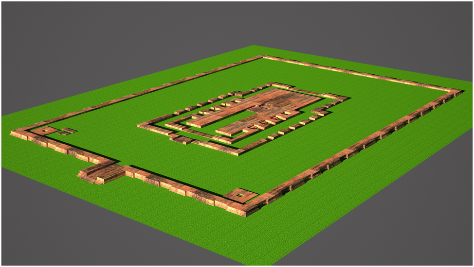
5.2.4 Fourth Reconstruction Era (Figures 15 and 16)
Rahman (1992, 25–28) states that during the fourth reconstruction, the temple’s dimensions increased from 43′ to 57′ (north-south), incorporating four idol cells. Due to the expansion, the circumnavigation pathway was enclosed, and it was reconstructed with a rectangular shape. The fence wall from the first to third era is found beneath the fourth floor. The primary path’s walls widened to 13 feet, constricting the 12-foot road to 8 feet. In this reconstruction era, the central Akshobhya idol’s cell has been enclosed, and the arched sewage platform/vedhi was reconstructed into a new altar. A cross-shaped stupa was constructed to the west of the temple, while three distinct stupas were erected to the east of the enclosure wall. Panel ornamentation was repurposed from previous periods, but its precise dating remains indeterminate.
Digitized ground plan of the fourth phase of the Itakhola Mound Temple, modified after Rahman (1992, 24).
Created 3D model of fourth phase of Itakhola Mound Temple.
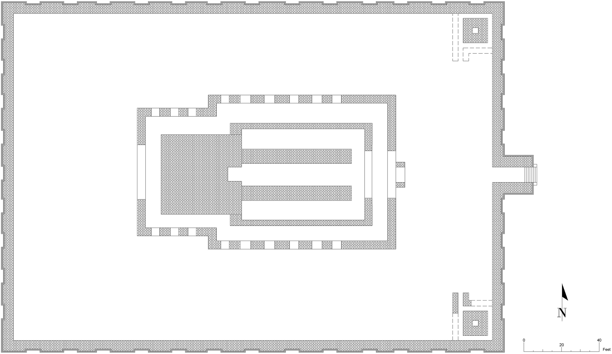
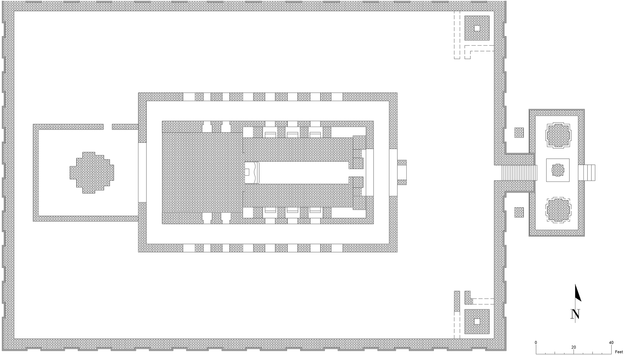
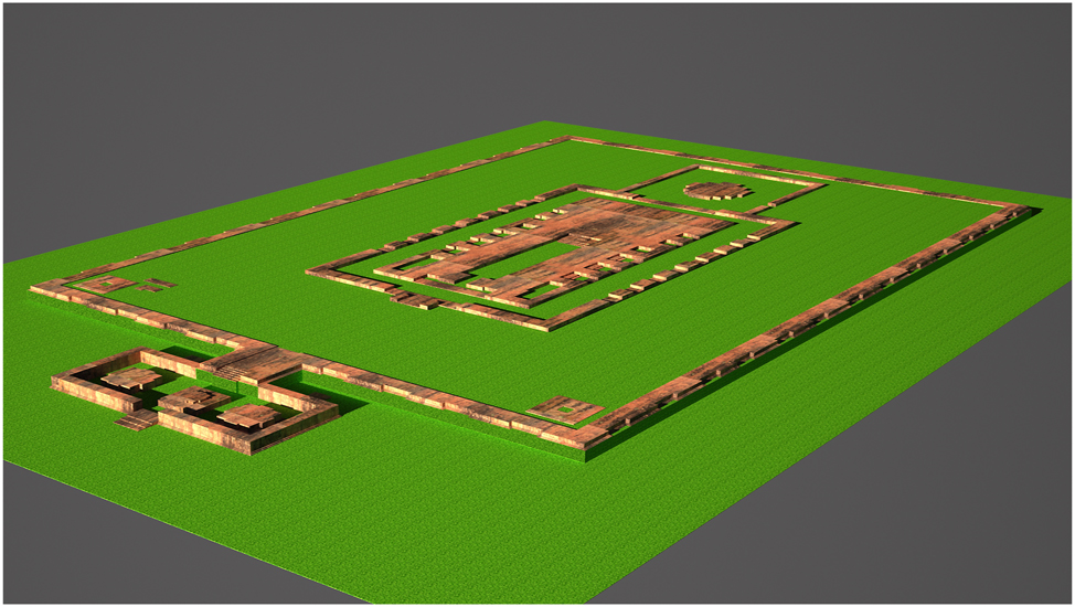
5.2.5 Fifth Reconstruction Era (Figures 17 and 18)
Rahman (1992, 28–29) mentioned that from a structural perspective, no notable changes have been observed during this period, apart from the reconstruction of a wider wall on either side of the temple’s main path and the subsequent narrowing of the main path itself. An additional altar was incorporated into the western cross-shaped stupa, and two mounds were constructed adjacent to the eastern stairway. Inside the enclosed area, multiple dispersed walls are found, making it impossible to formulate a comprehensive architectural design. The approximately 20-foot-high intact walls stand in stark contrast to the elaborately ornamented structures, such as Shalban, Ananda, Vasu, and Paharpur Viharas (Rahman 1992, 29). This architectural simplicity indicates cultural transition and, as highlighted in the excavation report, may signify the inception or early evolution of a millennium-old civilization at Devaparvata. However, a recent study does designate the proximate Ananda Vihara as the center of Devaparvata (Ridoy 2025, 164).
Digitized ground plan of the fifth phase of the Itakhola Mound Temple, modified after Rahman (1992, 27).
Created 3D model of the fifth phase of Itakhola Mound Temple.
6 Discussion
The study integrates digital technology and culture, making it essential to comprehend both the digital 3D model and its creation process, as well as the factors driving the changes. Prior to the ensuing discussion, Table 1 is provided below, illustrating the modifications across all reconstruction phases. This summary information will facilitate a clearer understanding of the discussion section.
The changes of all the reconstruction phases.
| 2nd Era | 3rd Era | 4th Era | 5th Era |
|---|---|---|---|
| 2.1. A supplementary 3′-3′ wall was constructed on either side of the major road in front of the statue. 2.2. This period signifies the existence of the residential area (?) within the temple, as demonstrated by the discovery of huge pots and other plates on the third floor. 2.3. The third floor was elevated by one foot. 2.4. The thickness of the outer enclosure wall was diminished from 6 feet to 5 feet. 2.5. The newly erected walls were marginally offset from the original wall of the first era. |
3.1. The monks’ living places (?) were entirely enclosed. 3.2. An additional wall, measuring 3′-0” in width, was constructed on both sides of the main road, resulting in a total wall width of 11′-3”. 3.3. A distinctive contemplative idol of Akshobhya Buddha was placed during this period, positioned in strata above the flooring of the preceding age. 3.4. It is believed that the two stupa/toilet components referenced in the first era were constructed during this third phase. 3.5. Twelve paved floors have been constructed on the main eastern gateway to the temple, resulting from frequent renovation. 3.6. On the other hand, only five paved floors were found in the entrance of the central worship house. 3.7. An east-oriented monastery, about 130 feet by 130 feet, was constructed 160 feet north of the main temple. |
4.1. The main temple, originally measuring 43 feet by 43 feet, was extended to 57 feet in the north-south direction, and four more idol cells were constructed on either side. 4.2. The north-south extension of the temple entirely obstructed the conventional circumambulation path established during the earlier 1st to 3rd reconstruction phases and a new circumambulation path was rebuilt. 4.3. The vedhi of the central Buddha sculpture was partially dismantled, and a new wall was constructed in its stead. 4.4. The walls flanking the main road were expanded to 13 feet, constricting the primary route from 12 feet to 8 feet. 4.5. The central platform/vedhi was elevated and transformed into an impressive second altar. 4.6. A cruciform stupa was constructed in the open courtyard on the west side of the temple, accompanied by three further stupas on the east side, which were enclosed by tiny walls. 4.7. The panel ornamentation is affixed to the exterior of the enclosure wall. |
5.1. The principal pathway of the central altar was further constricted by the erection of expansive walls on either side. 5.2. A new altar was incorporated within the cross-shaped stupa situated in the open courtyard on the western side. 5.3. Two new stupas were constructed between the enclosure wall and three stupas located adjacent to the staircase, specifically on either side of the east-facing stairway. 5.4. Remnants of several dispersed walls are observable within the open courtyard enclosed by the boundary wall. |
According to Table 1, the combined discussion is provided below, which will assist us in comprehending the probable reasons for the changes.
The Toilet Versus Stupa Controversy: The excavation report designates two structures in the temple’s northeast and southeast corners (Figure 10) as either toilets or stupas (Rahman 1992, 15). However, the presence of toilets within shrine premises is irrational. While the Vinaya Pitaka does not specify the exact distance between the toilet and the temple, it focuses on usage regulations (Horner 2015, 126–337; Tiwary and Saurabh 2018, 767); it is more rational for the toilet to be situated in the residential area rather than in the main temple. On the other hand, Figures 9 and 10 depict circumambulatory routes and altars around these two structures, indicating religious utilization. Furthermore, a drainage system is absent, which is required for toilets. Consequently, these are more likely to be stupas or ritual buildings rather than toilet facilities, thus maintaining the sacredness of the worship area.
Residential Place Versus Places of Worship Objects Controversy: The excavation report indicates the presence of household artefacts, including huge pots and plates, on the third floor (Figure 12) from the second reconstruction era (Rahman 1992, 17). Nonetheless, these restricted findings are inadequate to designate the area as residential. Given the temple’s principal religious function, these artefacts presumably facilitated ritual preparation, preservation, or ceremonial purposes. During the third construction phase, the open entrance was enclosed (Figure 14), and six idol chambers, three on each side with altars, were incorporated, signifying a transition towards heightened worship. These architectural modifications signify a shift that emphasises religious practices.
Numerous Idol Chambers and Shifts in Religious Paradigms: The number of idol cells in the Itakhola Mound temple, coupled with architectural alterations, suggests a profound connection between patronage and the development of religious doctrines. Historically, stupa idols were frequently incorporated via donations from royalty or the wealthy, as exemplified by the Sanchi Stupa (Goswami 2017, 134–35). In the fourth construction phase, four new idols were included in four chambers, whereas six chambers in the third phase presumably resulted from royal patronage.
The central cell (Figure 13), with a height of 227 cm and a width of 250 cm, is the place of the central idol Akshobhya Buddha, measuring 107 cm tall and 145 cm wide, originating from the third phase and despite the potential existence of an older idol beneath it, excavation was unfeasible due to the risk of displacement; advanced scanning technologies may make it possible in future (Rahman 1992, 23). A vedhi, standing 2 feet high, was constructed in front of the idol to raise the deity for ceremonial functions. The temple, initially measuring 43 × 43 feet, was enlarged to 57 feet in the north-south direction during the fourth phase (Figure 16), incorporating four cells and six cells from the third phase, to host other deities, indicating a transition from solitary to multi-idol worship.
Furthermore, the proportions of the chamber indicate this alteration: The altar in cell 4, on the northern side, has a width of 237 cm and a height to the top of 200 cm. Comparable measurements are seen in other cells: cell 5 (210 cm, 210 cm), cell 3 (210 cm, 190 cm), cell 2 (190 cm, 190 cm), and cell 1, on the southern side (180 cm, 183 cm). This consistency implies that sculptures comparable in dimensions to the Akshobhya Buddha were probably situated in these cells, signifying their equivalent ritual significance.
Theravada Buddhism is originally centred on the teachings of Gautama Buddha. Mahāyāna introduced the Panādhādhāṇa Buddhas, while Vajrayana emphasized Bodhisattvas and Tantric deities. This transformation is evident in the region’s iconography. Initial discoveries comprise sandstone Gautama Buddhas; thereafter, Akshobhya emerged, followed by Vajrayani/Sahajyani deities. Hiuen Tsang observed thirty sangharamas and 2,000 Hinayana monks at Samatata (Vikkho 1969, 52). The Lalmai-Mainamati region underwent a progression through Hinayana, Mahayana, Vajrayana, and Tantric stages over time. Rani Mainamati received instruction in Tantra from Siddhacharya Gorakshanath, demonstrating her impact on local Tantric traditions (Vikkho 1969, 60–68). Similarly, Kundu (2021) mentioned that during the sixth to twelfth centuries, the spread of tantrism was significantly influenced by Buddhist monarchs.
The finding of statues of Avalokiteshvara, Vajrasattva, Manjushri, Heruka, Tara, Manjuvara, Shadakshari Lokeshvara, and Singhnath Lokeshvara substantiates the increasing impact of Tantric practices. Copperplate inscriptions from the thirteenth century CE further corroborate the existence of Sahajayana (Vikkho 1969). Initially, Akshobhya just inhabited the center chamber; however, the emergence of Tantric deities necessitated the construction of other cells. Consequently, temple design embodies both religious evolution and socio-philosophical transition in Lalmai-Mainamati.
Concealing Endeavours and Religious Shift: In the fourth construction phase, the platform of the Akshobhya idol was partially dismantled (Figure 15), and a new wall was constructed at the same place. The whole idol, devoid of ball-and-socket joints for adjustment, implies deliberate obscuration. This signifies a transition: the former idol was concealed, and a movable metallic effigy presumably supplanted it. The diminishing significance of the Pancatathagata Buddhas and the increasing emphasis on Avalokiteshvara, as demonstrated by tantric manifestations, illustrates the impact of Vajrayana and Sahajayana traditions.
In the late eleventh century, the Buddhist Chandras were supplanted by the Brahmanical Varmans, and some Buddhist devotees concealed the statues underground at Jewari to safeguard them from the Varmans’ destruction (Bhattacharya 1989, 4). A comparable hiding may have transpired at the Itakhola Mound during the Varman reign (end of the eleventh and first half of the twelfth century CE). Despite the presence of political concerns, the architectural modifications, specifically the elevated vedhi and the repositioning of idols, indicate a profound intellectual transition from Mahayana to Vajrayana and Sahajayana traditions.
Increase of Worshippers and Construction of Monasteries: The excavation report indicates that during the third construction period, several structural modifications transpired along the eastern main passage. Twelve paved floors were discovered, indicative of recurrent reconstruction owing to extensive usage, reflecting an increasing number of devotees (Rahman 1992, 23). Conversely, five paved floors were found in the entrance of the central worship house, signifying moderated activity. The eastern entrance served as the primary entry route, while the central worship house was partially walled to create idol chambers, probably restricting public access and illustrating the religious rituals. Approximately 160 feet north of the temple, a 130 × 130 feet eastward-facing monastery containing 19 monks’ cells, a courtyard, and a well was constructed. The absence of it in earlier periods denotes the establishment of a monastery in the subsequent phase, indicating the emergence of devotees.
Path of Circumambulation: An essential aspect of Buddhist practice is pradakshina, which refers to the clockwise circumambulation of a stupa, altar, or idol (Bhat and Kumar B S 2022, 39; Setyani 2019, 7). In this context, the cruciform design was conceived; nevertheless, the temple in issue did not embody the intended harmonious pattern, according to the description of Hoque and Hoque (2019). During the fourth construction phase at the Itakhola temple, the original pradakshina path was completely impeded due to the temple’s north-south extension. A new rectangular circumambulatory route surrounding the main structure was rebuilt (Figure 16), enabling religious practices to persist despite the architectural upheaval.
Stupa: Early Buddhist literature and architecture exhibit several structures such as stūpas, mahācetiyas, cetiyas/caityas, topes, dagobas, and pagodas (Kim 2024, 1). At Itakhola Mound, different types of stupas (Figure 18) may indicate royal or noble patronage, akin to that of Emperor Ashoka (Rawat and Hameed 2019, 131). With the dissemination of Buddhism, stupa architecture developed, mirroring the artistic forms of other cultures (Goswami 2017, 129). Numerous comparable types are available at sites such as Paharpur and Shalban Vihara. Subsequently, three stupas were constructed on the eastern side and one on is western side, surrounded by walls. During the fifth phase, a new altar in the western stupa and two more stupas were constructed adjacent to the eastern staircase, presumably to augment rites. The distinctive stupa of the west is notable for its form and location and may have commemorated a particular monk. It features western and northern openings, although additional excavation is required to ascertain till when it ought to be regarded as a Nibedan/offering stupa.
Regulated Access to the Central Vedhi: The primary passage of the temple was originally constricted. During phase two, 3′–3″ broad walls were constructed on either side, diminishing the original 12′–9″ space to 9′–6″. Phase three included the addition of a 3′–0″ wall, resulting in a total height of 11′–3″, therefore enclosing the idol chamber. In phase four, wall extensions to 13 feet reduced the 12-foot path to 8 feet. During phase five, the walls were additionally reinforced to control movement (Figures 17 and 18). The modification sought to regulate the movement of devotees. Widening the walls facilitated flow management and mitigated structural deterioration.
Socio-Economic Context: The prior discourse elucidates the socio-religious backdrop of the period. The Itakhola Mound temple, akin to Shalban Vihara, Ananda Vihara, Kotbari Vihara, and Rani Mainamati Palace, was founded under royal patronage, indicative of the monarchy’s financial prosperity (Hasan and Siddique 2016, 74; Rashid 1997, 46). This patronage facilitated the creation, maintenance, and preservation of these sites. During the second phase, the third storey of the Itakhola temple was constructed by raising the floor by one foot, signifying structural deterioration and restoration. Comparable multi-phase reconstructions transpired at Shalban Vihara (Husain 2007, 61), corroborating the economic prowess of the dynasties. From the seventh to the eighth centuries CE, prior to the advent of Islam, the Lalmai-Mainamati region thrived as a Buddhist educational hub. The advancement of trade is also evident (Husain 1997, 90). These factors unequivocally indicate a stable economic structure during that period.
Religious Context: Religious shifting is apparent in this region. The area, initially influenced by Hinayana Buddhism in Samatata, then adopted Mahayana and Vajrayana, with Tantricism gaining prominence in the last century. The architectural modifications at Itakhola signify these transformations, as previously mentioned. On the other hand, terracotta plaques illustrating Krishna narratives at Shalban Vihara (Uddin and Rezowana 2015, 287–300) offer direct evidence of Hindu governance, probably during the Varman dynasty, as they were adherents of Hinduism (Husain 2007, 7).
This signifies a progressive shifting among religious practice, from Hinayana to Mahayana, followed by Vajrayana, Tantricism, and Sahajayana, as evidenced by the evolving style and iconography of the temple. Initially, Hinduism predominated in the region, which subsequently came under the influence of Islam. Till now, Islam is the dominant religion in this region, and in Bangladesh, Buddhism, Hinduism, and Islam are all practised in the Lalmai-Mainamati region.
Advantages of 3D Modelling-Based Virtual Preservation: The advantages of this form of virtual preservation may enhance our comprehension of the concealed or obliterated architectural elements of the structure. Moreover, digitizing these materials might yield further advantages, including global accessibility if they are uploaded to a designated web server.
Furthermore, it is feasible to establish a virtual museum that utilizes this form of virtual preservation, integrating supplementary 3D features. In this context, two types of 3D archaeological heritage models can be displayed. The first format is the as-it-is format, produced by the photogrammetry technique, as demonstrated in the works of CyArk (2020a, 2020b), Shourov (2022), and others. The alternative format is the predictive virtual reconstruction format, as demonstrated in the studies of Hasan (2025), Imran and Masud (2021a), Naqi et al. (1999), among others. Access to the virtual museum may depend on a premium subscription model or may be offered through open access.
If the laser scanning method and photogrammetry method, particularly utilizing Unmanned Aerial Vehicles (UAVs), become readily accessible in the future, the rate of capturing in its as-it-is format may increase. Additionally, an increase in research utilizing this methodology or more sophisticated forms of solid modelling in the future is anticipated to enhance the capacity to forecast and analyze the structural attributes of ancient structures. Consequently, utilizing both the as-it-is and predictive form, archaeological heritage will be accessible to a greater number of individuals than it is currently, more specifically in the context of AR and VR-based cultural heritage education. According to some recent research, Augmented Reality (AR) and Virtual Reality (VR) are gaining popularity day by day (Ridoy et al. 2025; Hasan 2024; Yanti et al. 2025; Perra et al. 2019). Subsequently, this type of study will facilitate the development of augmented and virtual reality-based cultural heritage education for students.
7 Concluding Remarks
The study has provided a preliminary understanding of the solid three-dimensional modelling method, focusing on the reconstruction phases of the Itakhola Mound Temple. The digital virtual reconstruction has visualized the five main reconstruction phases of the temple, enabling a fuller comprehension of its architectural modifications over time and their probable reasons. This approach has demonstrated that virtual modelling may effectively elucidate the structural evolution of archaeological sites.
Virtual preservation techniques are essential for archaeology since they safeguard sites by visualizing changes phase by phase, such as the Itakhola Mound Temple. This reconstruction of previous phases assists scholars in understanding obscured architectural features when analyzing historical development, religious shifting, or other viewpoints, hence ensuring vital data documentation. It enables the effective and sustainable comprehension of cultural heritage by providing researchers and learners remote access to archaeological sites both now and in the future, notwithstanding the deterioration of original structures.
This work underscores the growing importance of digital technologies in archaeological research, referred to as Digital Archaeology. The application of 3D modelling, which includes data acquisition through fieldwork and literature analysis, together with visualization using Autodesk AutoCAD and 3D Studio Max, has demonstrated the potential of virtual reconstructions in comprehending cultural heritage. The progression of technology guarantees that these strategies will enhance the documentation and interpretation of historical sites efficiently.
Lastly, this study primarily demonstrates the modifications of the archaeological site Itakhola Mound temple by constructing solid 3D models, depicting the virtual representation of the temple’s five phases, and explaining the probable causes along with additional perspectives such as religious shifts and socio-economic conditions; the expectation is that this will assist in subsequent research.
References
Alam, M. S. 2024. Physical Interview, with the Custodian of Mainamati Museum, on Information of Lalmai-Mainamati Sites.Suche in Google Scholar
Alam, M. S., A. B. Keysar, and M. Amiruzzaman. 2021. “Archaeological Sites of Lalmai-Mainamati.” In Updating the UNESCO World Heritage Tentative List of Bangladesh 2021, 93–103. Department of Archaeology.Suche in Google Scholar
Arias, F., C. Enríquez, J. M. Jurado, L. Ortega, A. Romero-Manchado, and J. J. Cubillas. 2022. “Use of 3D Models as a Didactic Resource in Archaeology. A Case Study Analysis.” Heritage Science 10 (1): 112. https://doi.org/10.1186/s40494-022-00738-x.Suche in Google Scholar
Barney, N., and R. Sheldon. n.d. “3D (Three Dimensions or Three Dimensional).” WhatIs.Com. https://www.techtarget.com/whatis/definition/3-D-three-dimensions-or-three-dimensional.Suche in Google Scholar
Begum, A. 2010. Pratnanidarshan: Cumilla [The Archaeological Monument of Cumilla]. University Grants Commission of Bangladesh.Suche in Google Scholar
Bhat, V., and K. Kumar B S. 2022. “The Significance of Pradakshina: An Outline.” Journal of Veda Sanskrita Academy 1 (April): 39–44.Suche in Google Scholar
Bhattacharya, A. K. 1989. Jhewari Bronze Buddhas: A Study in History and Style. Kolkata: Museum.Suche in Google Scholar
“Cattagram Bibhager Sangrakhita Ghosita Purakirtir Talika [List of Declared Antiquities of Chittagong Division].” 2021. Department of Archaeology, Ministry of Cultural Affairs, Government of The People’s Republic of Bangladesh.Suche in Google Scholar
Cutting, J. E., and P. M. Vishton. 1995. “Perceiving Layout and Knowing Distances.” In Perception of Space and Motion, 69–117. Elsevier.10.1016/B978-012240530-3/50005-5Suche in Google Scholar
CyArk. 2020a. “Chunakhola – Mosque City of Bagerhat.” OpenHeritage3D. https://doi.org/10.26301/74V4-K412.Suche in Google Scholar
CyArk. 2020b. “Sixty Dome Mosque – Mosque City of Bagerhat.” OpenHeritage3D. https://doi.org/10.26301/SY7X-FZ63.Suche in Google Scholar
Feng, Guanglin. 2015. “The 3D Solid Modeling Technology and its Applications in Machine Design.” In Proceedings of the 2015 International Conference on Intelligent Systems Research and Mechatronics Engineering, edited by Junhong Liu, Yongfei Wang, and Huaying Xu. Atlantis Press.10.2991/isrme-15.2015.157Suche in Google Scholar
Ferdani, D., E. Demetrescu, M. Cavalieri, G. Pace, and S. Lenzi. 2020. “3D Modelling and Visualization in Field Archaeology. From Survey to Interpretation of the Past Using Digital Technologies.” GROMA: Documenting Archaeology 4 (April). https://doi.org/10.12977/groma26.Suche in Google Scholar
Forte, M. 2014. “3D Archaeology: New Perspectives and Challenges – The Example of Çatalhöyük.” Journal of Eastern Mediterranean Archaeology and Heritage Studies 2 (1): 1–29. https://doi.org/10.5325/jeasmedarcherstu.2.1.0001.Suche in Google Scholar
Goswami, B. 2017. “The Sanchi Stupa: One Epicentre of Buddhist Architecture and Philosophy.” PANCHAKOTesSAYS 8 (2): 129–39.Suche in Google Scholar
Grosman, L., A. Karasik, O. Harush, and U. Smilanksy. 2014. “Archaeology in Three Dimensions: Computer-Based Methods in Archaeological Research.” Journal of Eastern Mediterranean Archaeology and Heritage Studies 2 (1): 48–64. https://doi.org/10.5325/jeasmedarcherstu.2.1.0048.Suche in Google Scholar
Hasan, M. S. 2024. “Augmented Reality and Virtual Reality Tools: The Combined Flavor of Books and Modern Technology in Preschool Education.” Itihas Prabandhamala 21 (19): 571–81.Suche in Google Scholar
Hasan, M. 2025. “Revolutionizing Cultural Heritage Preservation in Bangladesh: Virtual Reality Integration at Chhoto Sona Mosque.” International Journal of Research and Innovation in Applied Science X (I): 499–514. https://doi.org/10.51584/IJRIAS.2025.1001039.Suche in Google Scholar
Hasan, M. M., and M. Z. R. Siddique. 2016. “Impacts of Tourism Development on Local Community: A Study on Shalban Vihara.” Bangladesh Journal of Tourism 1 (1): 74–82.Suche in Google Scholar
Hoque, S., and M. M. Hoque. 2019. “New Understanding of Buddhist Cruciform Temples in Early Medieval Bengal.” Pratnatattva: Journal of the Department of Archaeology, Jahangirnagar University 25 (June): 93–104.Suche in Google Scholar
Horner, I. B. 2015. The Book of the Discipline: (Vinaya-Pitaka), Vol. 5. Cullavagga: Forgotten Books.Suche in Google Scholar
Huda, M. N., M. M. H. Khan, and M. Sadequzzaman. 2021. “Tentatively Listed Two Promising UNESCO World Heritage Sites of Bangladesh: Some Observations and Prospects of the Present Heritage Management Scenario.” Journal of Bengal Art 26: 673–89.Suche in Google Scholar
Husain, S. 1997. “History Society Culture.” In Mainamati-Devaparvata. A Survey of Historical Monuments and Sites in Bangladesh, SHMSB 001, Vol. 1, edited by A. B. M. Husain, M. H. Rashid, A. M. Chowdhury, and A. H. Imamuddin, 76–92. Asiatic Society of Bangladesh.Suche in Google Scholar
Husain, A. B. M. 2007. “Part One: Ancient Period.” In Architecture: A History Through the Ages, 3–56. Cultural Survey of Bangladesh 2. Asiatic Society of Bangladesh.Suche in Google Scholar
Imam, A. 2000. Excavation at Mainamati: An Exploratory Study. Studies in Bengal Art Series 2. The International Centre for Study of Bengal Art.Suche in Google Scholar
Imran, M. M., and M. Masud. 2016. “Keeping Alive the Sultanate Past of Bangladesh by Using 3D Modelling and Virtual Reality as Tools for Assisting Archaeology and Generating the Predictive Models of World Cultural Heritage Sites – the Case Study of Town and Mosques of Shait Gumbad Mosque Region.” Pratna Samiksha: A Journal of Archaeology 7. https://www.academia.edu/29789476/Keeping_Alive_the_Sultanate_Past_of_Bangladesh_by_Using_3D_Modelling_and_Virtual_Reality_as_Tools_for_Assisting_Archaeology_and_Generating_the_Predictive_Models_of_World_Cultural_Heritage_Sites_The_Case_Study_of_Town_and_Mosques_of_Shait_Gumbad_Mosque_Region.Suche in Google Scholar
Imran, M. M., and M. Masud. 2021a. “Predictive 3D Modelling and Virtual Reality of the World Cultural Heritage of Ruins of the Buddhist Vihara at Paharpur, Bangladesh.” In Heritage, Vol. 10, edited by Daniela Turcanu-Carutiu. IntechOpen.Suche in Google Scholar
Imran, M. M., and M. Masud. 2021b. “Virtual Heritage of the Saith Gumbad Mosque, Bangladesh.” In Proceedings of International Conference on Trends in Computational and Cognitive Engineering, edited by M. Shamim Kaiser, Anirban Bandyopadhyay, Mufti Mahmud, and Kanad Ray, 417–29. Springer.10.1007/978-981-33-4673-4_33Suche in Google Scholar
Khan, M. M. H., and M. N. Huda. 2023. “The Role of Museums and Communities in Sustainable Heritage Site Management in Bangladesh: The Case Study of Mahasthangarh.” In Conservation of Urban and Architectural Heritage - Past, Present and Future, edited by Kabila Hmood. IntechOpen.Suche in Google Scholar
Kim, Y.-J. 2024. “From Stupa to Pagoda: Re-Examining the Sinification and Transformation of Buddhist Monuments from Indian Origins.” Religions 15 (6): 640. https://doi.org/10.3390/rel15060640.Suche in Google Scholar
Kundu, S. R. 2021. “The Primordial Buddhism Transformed into Tantrism: An Attempt to Archaeological Observations in Southeast Bengal.” Pratnatattva: Journal of the Department of Archaeology, Jahangirnagar University 27 (June): 15–24.Suche in Google Scholar
Monsor, M. H. 2014. “Lalmai Paharsreny [Lalmai Hill Range].” In Banglapedia: National Encyclopaedia of Bangladesh. Dhaka: Asiatic Society of Bangladesh.Suche in Google Scholar
Morrison, B. M. 1974. Lalmai a Cultural Center of Early Bengal: An Archaeological Report and Historical Analysis. University of Washington Press.Suche in Google Scholar
Muenster, S. 2022. “Digital 3D Technologies for Humanities Research and Education: An Overview.” Applied Sciences 12 (5): 2426. https://doi.org/10.3390/app12052426.Suche in Google Scholar
Münster, S., F. I. Apollonio, I. Bluemel, F. Fallavollita, R. Foschi, M. Grellert, et al.. 2024. “3D Modeling.” In Handbook of Digital 3D Reconstruction of Historical Architecture. Synthesis Lectures on Engineers, Technology, & Society, Vol. 28, edited by S. Münster, F. I. Apollonio, I. Bluemel, F. Fallavollita, R. Foschi, M. Grellert, et al., 107–28. Nature Switzerland: Springer.10.1007/978-3-031-43363-4_6Suche in Google Scholar
Naqi, M. A., Z. Islam, M. S. Bhuiyan, and C. D. Gomes. 1999. “The Virtual Reconstruction of Paharpur Vihara.” Khulna University Studies November: 187–204. https://doi.org/10.53808/kus.1999.1.2.187-204-se.Suche in Google Scholar
Nasson, B. 2002. “History: The Meaning and Role of History in Human Development.” In Knowledge for Sustainable Development: An Insight into the Encyclopedia of Life Support Systems, Vol. 1, 651–67. UNESCO.Suche in Google Scholar
Perra, C., E. Grigoriou, A. Liotta, W. Song, C. Usai, and D. Giusto. 2019. “Augmented Reality for Cultural Heritage Education.” In 2019 IEEE 9th International Conference on Consumer Electronics (ICCE-Berlin), 333–6. IEEE.10.1109/ICCE-Berlin47944.2019.8966211Suche in Google Scholar
Qadir, M. A. 1997. “Recent Excavations.” In Mainamati-Devaparvata, Vol. 1, edited by A. B. M. Husain, M. H. Rashid, A. M. Chowdhury, and A. H. Imamuddin, 93–124. A Survey of Historical Monuments and Sites in Bangladesh, SHMSB 001. Asiatic Society of Bangladesh.Suche in Google Scholar
Rahman, H. 1992. Itakhola Bihar (7tom-13sho Sotok Porzonto Bouddha Sabbhatar Nidorshon) [Itakhola Vihara (Buddhist Civilization Monuments of till 7th to 13th Century)]. Department of Archaeology, Ministry of Cultural Affairs, Government of The People’s Republic of Bangladesh.Suche in Google Scholar
Rahman, A. K. M. S., and M. S. Alam. 2023. Protatttik Jorip o Onushondhan Protibedon: (2021–2022) Cumilla Zilla (Sadar Dokshin o Borura Upazila) [Archaeological Survey and Investigation Report: (2021–2022) Cumilla District (Sadar Dakshin and Barura Upazila)]. Office of the Regional Director (Chattogram and Sylhet Division), Department of Archaeology.Suche in Google Scholar
Rahaman, H., and B. B. Sharma. 2005. “Some Thoughts on Digital Documentation and its Application for Preserving the Architectural Heritage of Bangladesh.” Plan 3 (1): 11–21.Suche in Google Scholar
Rahman, H., N. Kabir, A. T. M. M. Reza, and S. M. Nazimuddin. 2008. “Preserving the Architectural Heritage of Bangladesh: An Approach to Digital Documentation.” Pratnatattva 14: 81–8.Suche in Google Scholar
Rahtz, S., and P. Reilly. 2003. Archaeology and the Information Age. One World Archaeology. Taylor & Francis.10.4324/9780203168349Suche in Google Scholar
Rashid, M. H. 1997. “Site and Surroundings.” In Mainamati-Devaparvata, Vol. 1, edited by A. B. M. Husain, M. H. Rashid, A. M. Chowdhury, and A. H. Imamuddin, 1–75. A Survey of Historical Monuments and Sites in Bangladesh, SHMSB 001. Asiatic Society of Bangladesh.Suche in Google Scholar
Rashid, M. H. 2021. “Itakhola Mura [Itakhola Mound].” In Banglapedia: National Encyclopedia of Bangladesh. Asiatic Society of Bangladesh.Suche in Google Scholar
Rawat, B., and M. Hameed. 2019. “Origin and Development of Buddha Stupa: An Overview of Textual Narratives.” Ancient Punjab 7: 121–43.Suche in Google Scholar
Remondino, F., and S. Campana, eds. 2014. 3D Recording and Modelling in Archaeology and Cultural Heritage: Theory and Best Practices. BAR International Series 2598. Archaeopress.10.30861/9781407312309Suche in Google Scholar
Ridoy, N. A. 2023. “The Potentiality of Digital Archaeology in Bangladesh: Perspective on Lalmai-Mainamati Region”. Unpublished Monograph. Department of Archaeology, Comilla University.Suche in Google Scholar
Ridoy, N. A. 2025. “Understanding the Spatial Pattern of the Archaeological Sites of Lalmai-Mainamati Using GIS and Remote Sensing: A Study Based on the Computational Archaeology”. Unpublished Master’s Thesis. Department of Archaeology, Comilla University.Suche in Google Scholar
Ridoy, N. A., M. M. H. Khan, and M. Hasan. 2025. “Augmented Reality (AR) Based Cultural Heritage Education for Achieving the SDG’s Goal 4: A Review from the Digital Archaeological Perspective.” In Book of Abstracts, Vol. 89. University of Rajshahi: Rajshahi University Research Society (RURS).Suche in Google Scholar
Setyani, T. 2019. “Heritage of Hindu-Buddhist Thought: Pradaksina and Prasavya Perspective in Tantu Panggelaran Text.” In Proceedings of the 2nd Workshop on Language, Literature and Society for Education. EAI.10.4108/eai.21-12-2018.2282768Suche in Google Scholar
Shourov. 2022. “Paharpur Exterior.” Sketchfab. October 27, 2022. https://sketchfab.com/models/1f04879f199b4c3e9c5513545ddb2f72/embed?autostart=1.Suche in Google Scholar
Sulistyani, H. 2024. “A Digital Preservation for the Indonesian First Terminus.” Preservation, Digital Technology & Culture 53 (2): 51–60. https://doi.org/10.1515/pdtc-2024-0008.Suche in Google Scholar
“Three-Dimensional”. 2025. Cambridge Dictionary, online: Cambridge University Press. https://dictionary.cambridge.org/dictionary/english/three-dimensional.Suche in Google Scholar
Tiwary, S. K., and S. Saurabh. 2018. “Archaeological Evidences of Toilet System in Ancient India.” Heritage: Journal of Multidisciplinary Studies in Archaeology 6: 764–81.Suche in Google Scholar
Trognitz, M., V. Gilissen, B. Fanini, K. Fernie, R. Scopigno, S. Stuhec, et al.. n.d. “3D Models in Archaeology.” Archaeology Data Service. https://archaeologydataservice.ac.uk/help-guidance/guides-to-good-practice/data-analysis-and-visualisation/3d-models/aims-and-objectives/3d-models-in-archaeology/ (Accessed July 9, 2023).Suche in Google Scholar
Uddin, M. S., and S. Rezowana. 2015. “The Portrayal of Krishna Legend in Terracotta Plaques of Recently Excavated Temple in Bhabodeva Vihara.” Journal of Bengal Art 20: 287–300.Suche in Google Scholar
Vikkho, S. D. R. 1969. Mainamatir Itikotha [The History of Mainamati], 2nd ed. Sambodhi Society of Pakistan.Suche in Google Scholar
Waagen, J. 2019. “New Technology and Archaeological Practice. Improving the Primary Archaeological Recording Process in Excavation by Means of UAS Photogrammetry.” Journal of Archaeological Science 101 (January): 11–20. https://doi.org/10.1016/j.jas.2018.10.011.Suche in Google Scholar
Ware, C. 2022. “Structuring Two-Dimensional Space.” In Visual Thinking for Information Design, 43–64. Elsevier.10.1016/B978-0-12-823567-6.00003-3Suche in Google Scholar
Wenjun, H. 2008. “The Three-Dimensional User Interface.” In Advances in Human Computer Interaction, edited by Shane Pinder. InTech.10.5772/5910Suche in Google Scholar
Wyatt-Spratt, S. 2018. “Scanning Vs Photogrammetry: The Pros and Cons of Different 3D Modelling Techniques (Poster Presentation).” In National Archaeology Student Conference. Sydney: University of Sydney. https://www.researchgate.net/publication/344409693_Scanning_vs_Photogrammetry_the_pros_and_cons_of_different_3D_modelling_techniques?channel=doi&linkId=5f7289cfa6fdcc008644d29e&showFulltext=true.Suche in Google Scholar
Yanti, F., L. Lufri, and Y. Ahda. 2025. “Current Trends in Augmented Reality to Improve Senior High School Students’ Skills in Education 4.0: A Systematic Literature Review.” Open Education Studies 7 (1): 20240053. https://doi.org/10.1515/edu-2024-0053.Suche in Google Scholar
Zvietcovich, F., B. Castaneda, and R. Perucchio. 2015. “3D Solid Model Updating of Complex Ancient Monumental Structures Based on Local Geometrical Meshes.” Digital Applications in Archaeology and Cultural Heritage 2 (1): 12–27. https://doi.org/10.1016/j.daach.2015.02.001.Suche in Google Scholar
© 2025 the author(s), published by De Gruyter, Berlin/Boston
This work is licensed under the Creative Commons Attribution 4.0 International License.